Magellan RoadMate 1200 Support Question
Magellan RoadMate 1200 Support Question
Find answers below for this question about Magellan RoadMate 1200 - Automotive GPS Receiver.Need a Magellan RoadMate 1200 manual? We have 12 online manuals for this item!
Question posted by kpglyam on August 3rd, 2014
How To Update Maps On Magellan Roadmate 1200 With Sd Card
The person who posted this question about this Magellan product did not include a detailed explanation. Please use the "Request More Information" button to the right if more details would help you to answer this question.
Current Answers
Related Magellan RoadMate 1200 Manual Pages
Triton User Manual Addendum - English, French, Spanish - Page 1

Triton User Manual Addendum
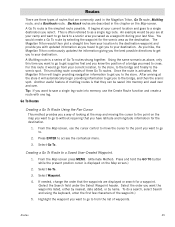
This addendum applies to Triton GPS receivers that have a software version that you will be presented with the option of ... To access area calculation, press ENTER while viewing the Map screen. With this example, the track was started at your Triton. Select "Pause Track Record".
In this software update you are done. Press ESC when you want to it...
Manual - English - Page 4
...transmitter.
Maximum normal use temperature is subject to the following two conditions: 1. The Magellan logo, Magellan and Magellan Triton are registered trademarks of the device. This transmitter must not be co-located or... follow the specific operating instructions for product updates and additional information. This device may cause undesired operation of MiTAC International Corporation. 604-0264-001...
Manual - English - Page 5
Table of Contents
Overview ...1 Features of the Magellan Triton 1 Specifications ...3
Fundamentals ...4 Turning the Triton on 4 Turning the Triton off 4 Setting the...the Large Data, Compass or Satellite Status Screen 12 Accessing the Map Screen Contextual Menu 13 Accessing the Compass or Speedometer Screen Contextual Menu 13
Map Screen ...13 Current Location Screen 13 Large Data Screen 14 ...
Manual - English - Page 6
... 29 Page Selection ...29
Profiles ...30 Activating a Profile 30 Editing a Profile 30 Information Page (assigns which navigation screens are displayed 30 Display Page 30 Map Page ...30 Sensors Page (Magellan Triton 500 31 Alarms Page ...31
Waypoints ...32 Waypoint Detail Screen Overview 32 Creating Waypoints 33 Creating a Current Location Waypoint from the...
Manual - English - Page 7
... 33 Creating a Waypoint from a Point on the Map Using the Triton Menu 34 Creating a Custom Waypoint from the Map Screen 34 Creating a Custom Waypoint Using the Triton ... 39 Setting Connectivity 39 Getting Software Version Information 40 Viewing Copyright Information 40 Personalizing Magellan Triton 40 Performing Diagnostic Checks 40
Geocache Waypoints ...42 Creating a Geocache Waypoint 42...
Manual - English - Page 8
... 52 Reversing a Trail 52 Hiding/Showing a Trail 52 Activating a Backtrack Route 53 Clearing Track 53
Places ...54 Go To a Place Waypoint (base map 54 Searching for a Place Waypoint (Detail Map 54 Turning On/Off the Waypoint Proximity Alarm for a Place Waypoint 55 Viewing Best Fish and Hunt Times for a Place Waypoint 55...
Manual - English - Page 9

... store media. Simple menus and an intuitive interface makes using the Magellan Triton easy for your purchase of possible software updates and new features as feature-packed National Geographic maps from an SD card that you for first time GPS receiver users while still keeping all the features needed to see. Get accurate compass readings while standing...
Manual - English - Page 10
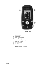
A
B
C E
F G
D I
H
Magellan Triton
A Backlight Button B Power Button C Zoom - (Zoom out) Button D Zoom + (Zoom in) Button E ENTER Button / Cursor Control F PAGE / GO TO Button G Esc (Escape) Button H Menu Button I SD Card Slot (under protective rubber cover)
[Magellan Triton 400 & 500 only]
Overview
2
Manual - English - Page 11

w/ battery 2.2" (5.59cm) diagonal, QVGA (240 x 320) resolution, LED backlit Internal memory or Secure Digital (SD) Card (optional accessory)
Built-in base map of the continental United States and Canada.
(In Europe, base map coverage may vary.) 4.65" x 2.16" x 1.22" (11.8 x 5.5 x 3.1 cm) 6.6 oz (187 g) - POWER
Source Battery Life
Two AA Batteries (not included) Up to 5 meters...
Manual - English - Page 14

... up the menu for information on an optional SD card (400 & 500) or into suspend mode when no keys pressed. Select Power Off Timer.
6. Accessing the Main Menu
1. From the Map Screen, press MENU. The Place option is done through the Main Menu. Check the Magellan website at www.magellangps.com for the corresponding...
Manual - English - Page 15

... playing MP3 music files. (Magellan Triton 400 & 500 only).
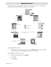
Navigation Screens
The Triton has eight navigation screens and a Satellite Status screen that can : Reset Odometer, Reset Trip Odometer, Reset Speed.
2. Navigation Screen options menus
The Map and Speedometer screens have been created and saved in a future update. Accessing the Map Screen Contextual Menu
1. While...
Manual - English - Page 16
... display navigation information. Select Customize Fields. 3.
Customizing the Data Field for the Map Screen
1.
Select the data type desired from the list shown and press ENTER. 6. While viewing the Map screen, select ENTER. 2. Magellan Triton 300 installs the National Geographic maps into their internal memory, while Magellan Triton 400 and 500 stores the maps on an SD card.
Manual - English - Page 19
.... 3. The Navigation screens provide you with information to select the navigation screen you in the Profile settings. CM
PAGE
C
ESC
OC
Magellan Triton 500 only
C Customizable screen O Optional screen* M Contextual menu
All screens (except the Map screen) can be turned on or off by default. Navigation Screens
11 Select Profiles.
Manual - English - Page 21
...
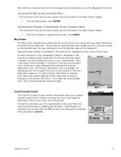
The functions of the various menu options will be discussed in the Map Screen chapter.
1. From the Compass or Speedometer screen, press MENU. Also, if you have a route activated, it appears as a blue dashed line (color is displayed on the Magellan Triton 500. A north indicator that rotates to the Speedometer screen and...
Manual - English - Page 27

This makes understanding the Map screen and all of the functions that can be performed directly from this screen an important part of getting the most commonly used screen in the Magellan Triton and it has a special contextual menu that has been saved in the receiver.)
Start Flag (Indicates the starting point of the...
Manual - English - Page 37
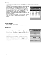
... uses a standard calendar display to enter dates for the Magellan Triton since the date is automatically received from ; Use the left and right arrows to select them from the GPS satellite. Multi-line fields (notes, comments, hints): 1024 characters. Information page, Media page and Alerts page. To change months.
The Waypoint Information screen...
Manual - English - Page 40
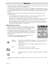
...the Triton can be done by saving your destination. The Magellan Triton has three different classifications for accepting the waypoint and ...being created, the Waypoint Detail screen is stored on the SD card and not in the chapter on geocaching, but you use ...that are special waypoints that have been preloaded into the base map or one of three pages that media assigned to your current...
Manual - English - Page 50

...Magellan Triton either by creating a geocache waypoint or by saving the geocache file from the SD card...Magellan Triton to find .
1. Select the the waypoint.
Scroll down the page to display the Details page. Geocache information includes Difficulty (1 through 5 with 5 being the most difficult), Terrain (1 though 5 with GPS... save
Geocaching
42 From the Map screen, press MENU. 2. ...
Manual - English - Page 53
... from the list of the waypoint.)
5. This is activated, the Magellan Triton will automatically begin providing navigation information to .
2. Tip: If you want to as a waypoint during your destination. From the Map screen, use the Create Route function and create a route with updated information as the destination. Highlight the waypoint you have latitude...
Manual - English - Page 65
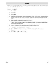
...the images are images available on the right side of the media options you need install an optional SD card in full screen. Press ESC to step through the saved photos. 7. Select View. 3. by date... to display the image in the SD card slot located on the SD card.) 5.
Browsing Photographs
1. Media
Before using any of the Magellan Triton. Select an image to the Browse Photos list. 8.
Similar Questions

I Found A Magellan Roadmate 1200. Is It Possible To View Maps W/o An Sd Card?
I found a Magellan RoadMate 1200. Is it possible to view maps w/o an SD card?
I found a Magellan RoadMate 1200. Is it possible to view maps w/o an SD card?
(Posted by horseflybite9 1 year ago)

How To Update Magellan Roadmate 1200 Thru Sd Card
(Posted by deljeff 9 years ago)
How To Update Magellan Roadmate 1200 For Free
(Posted by mayrcyn 10 years ago)

Is There A Europeon Map For Download/sd Card Maestro 3100
(Posted by nellew 11 years ago)

How I Get Original Roadmate 1412 Sd Card
(Posted by cunguyen53 11 years ago)