
Garmin eTrex 30 Support Question
Garmin eTrex 30 Support Question
Find answers below for this question about Garmin eTrex 30.Need a Garmin eTrex 30 manual? We have 2 online manuals for this item!
Question posted by dalKIRKRU on May 5th, 2014
Can't See Track On Etrex 30 Memory Card
The person who posted this question about this Garmin product did not include a detailed explanation. Please use the "Request More Information" button to the right if more details would help you to answer this question.
Current Answers
Related Garmin eTrex 30 Manual Pages
Owner's Manual - Page 3

... the Size of Contents
Getting Started 5 Device Overview 5 Using the eTrex Keys 6 Battery Information 7 Turning the Device On or Off.........8 Satellite Signals 8 Registering Your Device 8
Waypoints, Routes, and Tracks 9 Waypoints 9 Using Sight 'N Go 10 Where To? Table of... Menu........28 Customizing Specific Pages........28 Profiles 29 System Settings 30 Display Settings 30
3
Owner's Manual - Page 10

.... Select Sight 'N Go.
2. Move to the object, and select Done > Save.
10
eTrex Owner's Manual Using Sight 'N Go
Sight 'N Go is available on the eTrex 30. Enter the distance to the location.
4. Select Start.
5. Select Waypoint Averaging.
2. Waypoints, Routes, and Tracks
Increasing the Accuracy of a Waypoint Location Waypoint averaging allows you to increase the...
Owner's Manual - Page 11

Waypoints, Routes, and Tracks
Finding a Location by Name Depending on the maps loaded on the eTrex 20 and eTrex 30, such as BirdsEye™ satellite imagery, BlueChart® g2, TOPO, and City Navigator® detailed maps. Select Where To? > menu >
Search Near.
2. Select an option.
3. If necessary, select a location. eTrex Owner's Manual
11 categories are available...
Owner's Manual - Page 14

... a specified distance, select Distance.
14
• To record tracks at a variable rate that creates an optimum representation of your track.
3. Select Setup > Tracks > Track
Log.
2. If you move with the device turned on the map indicates your path. eTrex Owner's Manual Recording Track Logs 1. Select Record, Do Not Show or Record, Show On Map.
Select Record...
Owner's Manual - Page 15

...
Viewing the Elevation Plot of the track are marked by flags.
4. Select a saved track. 3. Select Archive. Viewing Track Information 1. Information about the track is called the current track.
1. Archiving a Saved Track You can archive saved tracks to save memory space.
1. Select Delete > Yes.
Select View Map. eTrex Owner's Manual
15 Select what you want to save :
•...
Owner's Manual - Page 17

• Select a location on the eTrex 20 and eTrex 30. Navigating a Driving Route Driving route navigation is using the automotive profile, the compass displays GPS heading, not magnetic heading. If you plan to use an auto mount accessory with the device, you must also purchase and install the mount in ...
Owner's Manual - Page 19

... pointer to navigate
to a destination (page 16).
2.
Details about a Point on the Plot
Select an individual point on the eTrex 30. Resetting the Elevation Plot Select Elevation Plot > menu > Reset > Clear Current Track > Yes. Elevation Plot
Elevation plotting is available on the plot. By default, the elevation plot displays the elevation for an...
Owner's Manual - Page 23

... about looking for the cache or the cache itself, select Add Comment, enter a comment, and select Done. A chirp is available on the eTrex 30. Select Geocaches > menu > Show
chirp™ Details.
2. eTrex Owner's Manual
23 Select Setup > Geocaches.
2. When you are within 33 feet (10 m) of the geocache that you can find a chirp...
Owner's Manual - Page 24

... device can share data wirelessly, you enter a proximity alarm area, the device sounds a tone (eTrex 20/30).
24
eTrex Owner's Manual Select Create Alarm.
3.
Select Share Wirelessly. 2. Applications
Applications
Sharing Data
The eTrex 30 can share waypoints, geocaches, routes, and tracks. When you must be within a specified range of a compatible Garmin device.
1. Follow the...
Owner's Manual - Page 26

... with your current location, GPS accuracy, satellite locations, and signal strength. Select Satellite > menu.
2. Turning Off GPS Select Satellite > menu > Use With GPS Off.
26
eTrex Owner's Manual The alarm sounds...the alarm.
Satellite Page
The satellite page shows your current track toward the top of that satellite (eTrex 20/30).
Applications
Setting an Alarm
If you are not currently ...
Owner's Manual - Page 34

...to a destination.
• Compass-switches from an electronic compass to a GPS compass when you turn the device on.
34
eTrex Owner's Manual
Select Setup > Altimeter.
• Auto Calibration-allows the ... on the compass.
• North Reference-sets the north reference of directional heading on the eTrex 30. Select Setup > Heading.
• Display-sets the type of the compass.
•...
Owner's Manual - Page 37

... Fishing-(requires marine maps) displays a detailed view of marine navigation aids on the map.
eTrex Owner's Manual
37
Select Setup > Marine.
• Marine Chart Mode-allows you want ...soundings. Customizing Your Device
Marine Map Settings
This function is available on the eTrex 20 and eTrex 30.
Simplifies map presentation for some guidance methods) allows you to select the ...
Owner's Manual - Page 43

... geocache files
Device Information
Installing a microSD Card The eTrex 20 and eTrex 30 can use microSD cards for more information.
1. Remove the batteries or battery.
3. It is not compatible with Mac® OS 10.3 and earlier. Go to remove the cover.
2. Also, some maps are available preloaded on memory cards. Slide the card holder ➊ toward the bottom...
Owner's Manual - Page 44
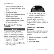
... from the mini-USB port ➋.
➊
➋
3. Place the microSD card ➋ in My Computer on Windows computers and as removable drives in the device ...Select Edit > Copy.
44
eTrex Owner's Manual Close the card holder.
6. Replace the batteries (page 7).
8. Device Information
4. Connect the USB cable to a computer.
1. Your device and memory card (optional) appear as mounted ...
Owner's Manual - Page 45
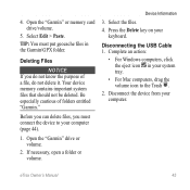
Select Edit > Paste.
Disconnecting the USB Cable 1. eTrex Owner's Manual
45
Before you can delete files, you do not know the purpose of folders entitled "Garmin." 4. Select the files.
4. Open the "Garmin" or memory card drive/volume.
5. Your device memory contains important system files that should not be deleted. Be especially cautious of a file, do...
Owner's Manual - Page 46

...cadence sensor with the accessory. or 3 m) of the ANT+ accessory.
2. Select Search for the eTrex 30.
Bring the device within range (10
ft. Select Heart Rate Monitor or Bike Cadence Sensor.
4. ... to send data to view the heart rate or cadence data (page 28).
46
eTrex Owner's Manual
Customize your device. Optional Fitness Accessories Fitness accessories are available at http://buy...
Owner's Manual - Page 55

...
profiles 30 routes 12 waypoints 9
eTrex Owner's Manual
elevation plot 19, 20 barometric altimeter 20 of a track 15
F file types 43 finding
addresses 12 near your location 11 fishing times 25 fitness options 46
G geocaches 21, 35
downloading 21 filter list 21 logging attempt 22 navigating to 22 settings 35 GPS signals 8, 26, 30, 47...
Quick Start Manual - Page 5

... accuracy, do not stand near objects that optimize your settings and views can significantly reduce battery life.
1.
Select Calibrate Compass > Start.
4. Select a profile.
The eTrex 30 has a 3-axis, electronic compass. Select Profile Change. 2. While the device is on -screen instructions. Calibrating the Compass
Notice Calibrate the electronic compass outdoors. Select Compass...
Quick Start Manual - Page 8

..., but fills up the device memory quicker. • Enter a time or distance, and select Done. Select a category. 3. The map page opens with your location on , a track log is created. The position icon represents your route marked with the Bearing Pointer The eTrex 30 has a 3-axis, electronic compass.
8
eTrex 20/30 Quick Start Manual As you move...
Quick Start Manual - Page 9

... a computer (page 9).
2. Go to a Computer
1. Select Compass.
3. Your device and memory card (optional) appear as removable drives in . 5. If necessary, create an account. 4.
Reinstall the... 2. Begin navigation to your data or settings.
9 Sign in My Computer on Windows
eTrex 20/30 Quick Start Manual
computers and as mounted volumes on -screen instructions
to find and download ...
Similar Questions

Is The Memory Card Needed For Geocaching With Garmin Etrex
(Posted by djrdju 10 years ago)

Garmin Etrex 30 Language
I have an eTrex 30 and the language not open ,could you please let me know what sall i do?
I have an eTrex 30 and the language not open ,could you please let me know what sall i do?
(Posted by mnazari123 10 years ago)

Garmin Etrex 30 Language Change
I accidentally selected the wrong language on initial start up. How do I set English as the language
I accidentally selected the wrong language on initial start up. How do I set English as the language
(Posted by vk3afw 10 years ago)

Can I Save Tracks Onto An Microsd Card In The Gps Instead Of Downloading Via Usb
I won't have a computer while in Central America, so I am wondering if it is possible to save lots o...
I won't have a computer while in Central America, so I am wondering if it is possible to save lots o...
(Posted by helixed2 11 years ago)