
Garmin eTrex 20 Support Question
Garmin eTrex 20 Support Question
Find answers below for this question about Garmin eTrex 20.Need a Garmin eTrex 20 manual? We have 2 online manuals for this item!
Question posted by NoorAkiddne on May 16th, 2014
Does My Garmin Etrex 20 Search For Geocaches Closest To My Current Location?
The person who posted this question about this Garmin product did not include a detailed explanation. Please use the "Request More Information" button to the right if more details would help you to answer this question.
Current Answers
Related Garmin eTrex 20 Manual Pages
Owner's Manual - Page 9

... 2. Select an item to edit, and select Done.
Select a waypoint. 3. Select an option:
• To save your current location as a waypoint.
1. Select Where To? > Waypoints. 2. Select a waypoint.
Enter the new information. 5.
eTrex Owner's Manual
9 Select Mark Waypoint. 2. Waypoints, Routes, and Tracks
Finding a Waypoint 1. Select Waypoint Manager. 2. Editing a Waypoint Before...
Owner's Manual - Page 11

... You can use the Where To? Waypoints, Routes, and Tracks
Finding a Location by Name Depending on the maps loaded on the eTrex 20 and eTrex 30, such as restaurants, hotels, and auto services.
1. Select Where To?.
2.
If necessary, select a location. Menu
You can search for cities, geographic points, and various points of interest (POIs), such as...
Owner's Manual - Page 17

.... Navigating a Driving Route Driving route navigation is using the automotive profile, the compass displays GPS heading, not magnetic heading. Before you can use the map, you must purchase and load City Navigator maps. • Select a location on the eTrex 20 and eTrex 30. Select Profile Change > Automotive.
2.
Calibrating the Compass
Notice Calibrate the electronic compass...
Owner's Manual - Page 24

..., geocaches, routes, and tracks.
You can share data wirelessly, you are within 10 feet (3 m) of a particular location.
1. Setting a Proximity Alarm
Proximity alarms alert you when you must be within a specified range of a compatible Garmin device.
1. Sending and Receiving Data Wirelessly Before you enter a proximity alarm area, the device sounds a tone (eTrex 20/30).
24
eTrex Owner...
Owner's Manual - Page 26

... screen.
3. Select Turn Alarm On. 4.
Satellite Page
The satellite page shows your current track toward the top of that satellite (eTrex 20/30). Changing the Satellite View 1.
Select Alarm Clock. 2. Select the clock numbers to be oriented with your current location, GPS accuracy, satellite locations, and signal strength. If necessary, select Multicolor to assign a specific color to...
Owner's Manual - Page 30

... turns off ). Select a profile. 3. System Settings
Select Setup > System.
• GPS-sets the GPS to http://www.garmin.com/ aboutGPS/waas.html.
• Language-sets the text language on the device.
Select...3. Note: To adjust the backlight brightness, see page 40.
• Colors (eTrex 20/30)-sets the colors that display in Night and Day mode.
◦◦ Mode-sets a light background ...
Owner's Manual - Page 31
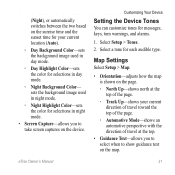
eTrex Owner's Manual
31
sets the background image used in day mode.
◦◦ Day Highlight Color-sets the color ...shown on the page.
◦◦ North Up-shows north at the top of the page.
◦◦ Track Up-shows your current location (Auto).
◦◦ Day Background Color-sets the background image used in night mode.
◦◦ Night Highlight Color-sets the ...
Owner's Manual - Page 33

...
2. You can customize units of the track line on your tracks. eTrex Owner's Manual
33 Changing the Units of measure for the setting. Customizing...and cleared automatically based on the user setting.
• Color (eTrex 20/30)-changes the color of measure for the device.
Select a ... to organize your GPS position.
Select Setup > Position Format.
• Position Format-sets the ...
Owner's Manual - Page 37

...features in different colors so that the marine POIs are within a specified distance of your current point.
• Avoidance Setup-(available only for some activities.
◦◦ Auto-automatically...readable.
Customizing Your Device
Marine Map Settings
This function is available on the eTrex 20 and eTrex 30. eTrex Owner's Manual
37 Select Setup > Marine.
• Marine Chart Mode-...
Owner's Manual - Page 43

... bottom of the device and lift up to remove the cover.
2. Go to http://www.garmin.com.
• GPI custom POI files from the Garmin POI Loader
• GPX geocache files
Device Information
Installing a microSD Card The eTrex 20 and eTrex 30 can use microSD cards for more information.
1.
Turn the D-ring counter-clockwise, and pull...
Owner's Manual - Page 48
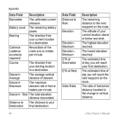
... the next waypoint on the route. Descent Average
The average vertical distance of horizontal distance traveled to a destination. eTrex Owner's Manual Bearing
The direction from your current location above or below sea level.
The lowest elevation reached. The estimated time of the crank arm or strides per minute. Cadence (cadence accessory required)
Revolutions...
Quick Start Manual - Page 2
... a destination (page 8).
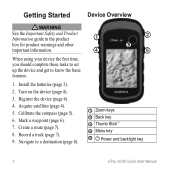
➊
➋
➌
➍
➎
➊ Zoom keys ➋ Back key ➌ Thumb Stick™ ➍ Menu key
➎ Power and backlight key
2
eTrex 20/30 Quick Start Manual Create a route (page 7).
8. Install the batteries (page 3).
2. Calibrate the compass (page 5).
6. Record a track (page 7).
9.
Quick Start Manual - Page 3
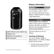
...two AA batteries. Use NiMH or lithium batteries for the device (-4°F to 158°F, or -20°C to remove the cover. Therefore, use alkaline, NiMH, or lithium batteries.
Installing AA Batteries ...Information
‹ warning The temperature rating for best results.
1.
eTrex 20/30 Quick Start Manual
3
notice Alkaline batteries lose a significant amount of some batteries.
Quick Start Manual - Page 4

... Adjusting the Backlight
Note: The backlight brightness may need a clear view of screen backlighting
eTrex 20/30 Quick Start Manual
Select Alkaline, Lithium, or
Rechargeable NiMH. Extensive use of the ...more information about GPS, go to http://my.garmin.com. • Keep the original sales receipt, or a
photocopy, in the batteries is turned on the GPS position. When the GPS bars on the...
Quick Start Manual - Page 5

... locations ...geocaching and for navigating on how you record and store in the device. The eTrex 30 has a 3-axis, electronic compass. Select Profile Change. 2. Waypoints
Waypoints are using it.
Select Compass. 2. You should calibrate the compass after moving long distances, experiencing temperature changes, or changing the batteries.
1. Select Calibrate Compass > Start.
4.
eTrex 20...
Quick Start Manual - Page 6

... collecting multiple samples of the waypoint location.
1. categories are available in all Where To? eTrex 20/30 Quick Start Manual Select a waypoint. 3. Select Go. Select an option:
• To save your device, you to the location. 4. Increasing the Accuracy of a Waypoint Location Waypoint averaging allows you can search for the waypoint, waiting at least 90 minutes...
Quick Start Manual - Page 7
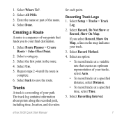
Select Done.
Select Use. 5. Tracks
A track is
complete. 6.
eTrex 20/30 Quick Start Manual
7 Select Where To?. 2. Enter the name or part of ... an optimum representation of the name. 4. The track log contains information about points along the recorded path, including time, location, and elevation
for each point. Select Record, Do Not Show or Record, Show On Map. Select an option:
&#...
Quick Start Manual - Page 8

...icon moves.
2. Select a category. 3. The position icon represents your route marked with the Bearing Pointer The eTrex 30 has a 3-axis, electronic compass.
8
eTrex 20/30 Quick Start Manual Complete one or more or less often. Tip: To customize the map view, select menu... to record tracks more actions:
• Use the Thumb Stick to move with your location on , a track log is created.
Quick Start Manual - Page 9

...
2. Connect the USB cable to a USB port on Mac computers. Follow the on Windows
eTrex 20/30 Quick Start Manual
computers and as removable drives in that direction to the destination. Select ... you are moving in My Computer on -screen instructions
to find and download geocaches to your computer.
2. Downloading Geocaches
1. If necessary, create an account. 4. note: This does not erase ...
Quick Start Manual - Page 10
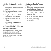
... the USA, call (913) 397.8200 or (800) 800.1020.
• In the UK, call 0808 2380000.
• In Europe, call +44 (0) 870.8501241.
10
eTrex 20/30 Quick Start Manual Open the "Garmin" drive or volume.
5.
Double-click START HERE.html. Connect your Garmin dealer. Getting the Manuals from the mini-USB port.
3.
Similar Questions

How Can I Download A Gpsx File (track) Onto My Garmin Etrex 20 Device
Have recently bought an etrex 20 GPS (Live in New Zealand) and would like to down load the "Te Araro...
Have recently bought an etrex 20 GPS (Live in New Zealand) and would like to down load the "Te Araro...
(Posted by helenosephius 8 years ago)


On What Screen Does It Show My Current Location ... Is It The Blue Arrow ?
(Posted by moeysworkshop 12 years ago)