
Garmin eTrex 20 Support Question
Garmin eTrex 20 Support Question
Find answers below for this question about Garmin eTrex 20.Need a Garmin eTrex 20 manual? We have 2 online manuals for this item!
Question posted by danajd on November 9th, 2015
What Is The Blue Circle With Short Black Stem On My Map Screen?
The person who posted this question about this Garmin product did not include a detailed explanation. Please use the "Request More Information" button to the right if more details would help you to answer this question.
Current Answers
Answer #1: Posted by TommyKervz on November 25th, 2015 10:40 AM
TommyKervz

Member since:
January 10th, 2013 Points: 17,776,843

Member since:
January 10th, 2013 Points: 17,776,843
The owners manual should be able to explain all symbols and icons of the unit. Download manual here https://www.helpowl.com/manuals/Garmin/eTrex20/118746
Related Garmin eTrex 20 Manual Pages
Owner's Manual - Page 3

...........28 Profiles 29 System Settings 30 Display Settings 30
3 Menu 11 Routes 12 Tracks 14
Navigation 16 Navigating to a Destination..........16 Map 16 Compass 17 Elevation Plot 19 Trip Computer 20
eTrex Owner's Manual
Table of Contents
Geocaches 21 Downloading Geocaches 21 Filtering the Geocache List..........21 Navigating to a Geocache............22 Logging the...
Owner's Manual - Page 4

...Marine Map Settings 37 Fitness 38 Resetting Data 38 Changing the Page Sequence.....39
Device Information 40 Adjusting the Screen ...40 Updating the Software 40 Viewing Device Information..........40 Specifications 41 About the Batteries 41 Caring for the Device 42 Data Management 43
Appendix 46 Optional Accessories 46 Data Field Options 47 Troubleshooting 52
Index 54
4
eTrex...
Owner's Manual - Page 6

... the highlighted item.
• Press back to move back one step in the menu structure.
• Press menu to zoom in and out on the map.
6
eTrex Owner's Manual Getting Started
➏ ➐
➑ ➒
➏ Mini-USB port (under weather cap) ➐ Battery cover ➑ Battery cover locking ring ➒ Mounting...
Owner's Manual - Page 11

... > Spell Search.
4. Select Where To? > menu >
Search Near.
2. categories are available in all areas and maps. eTrex Owner's Manual
11 Where To? Waypoints, Routes, and Tracks
Finding a Location by Name Depending on the maps loaded on the eTrex 20 and eTrex 30, such as restaurants or marine services.
Select a category.
3. Finding a Location Near Another Location 1. Additional...
Owner's Manual - Page 12

... a category. 3. Select back to your final destination. Select Change Name. 4. Enter the city or postal code.
NOTE: Not all map data provides postal code searching. 4. Enter the house number. 6. Select Done.
12
eTrex Owner's Manual Editing the Name of waypoints that leads you to save the route.
Select Where To? > Addresses. 2. Repeat...
Owner's Manual - Page 13

....
5. Select Route Planner. 2.
Viewing the Active Route 1. eTrex Owner's Manual
13 Select a route.
3. Select an option:
• To view the point on the map, select Review.
• To change the order of the ... route, select Move Down or Move Up.
• To add an additional point on the Map 1. Deleting a Route 1. Select a route. 3. Select Reverse Route. The additional point is...
Owner's Manual - Page 14

...
• Enter a time or distance, and select Done.
eTrex Owner's Manual Select Record, Do Not Show or Record, Show On Map. Select an option:
• To record tracks at a ... Waypoints, Routes, and Tracks
Tracks
A track is created. If you move with the device turned on the map indicates your tracks, select Auto.
• To record tracks at a specified distance, select Distance.
14
&#...
Owner's Manual - Page 15

... Manager > Current Track.
2. The beginning and the end of a Track 1. Select Elevation Plot.
eTrex Owner's Manual
15 Select what you want to save :
• Select Save Track.
• Select... Select a track. 3. Select Track Manager. 2. Select View Map.
Saving the Current Track The track being recorded is listed. Select Track Manager. 2. Viewing Track Information 1. ...
Owner's Manual - Page 16

... Use the Thumb Stick to pan the map to view different areas.
• Select ▲ and ▼ to a destination, your route marked with a magenta line on the map.
As you are navigating to zoom in...track, to a waypoint, to a geocache, or to your location on the map.
Select Go. You can use the map (page 16) or compass (page 17) to navigate to any saved location in and...
Owner's Manual - Page 17

... > Automotive.
2.
eTrex Owner's Manual
17 Navigating a Driving Route Driving route navigation is using the automotive profile, the compass displays GPS heading, not magnetic heading. Use the map to navigate to your... map, you must also purchase and install the mount in the text bar along the top of the screen shows information about the selected location. Navigation
Compass
The eTrex 30...
Owner's Manual - Page 18

...).
2.
The course line to your destination is most useful if you drift from the intended course to the destination.
Begin navigation to the distance
18
eTrex Owner's Manual Select Compass.
3. Follow the on water or where there are moving long distances, experiencing temperature changes, or changing the batteries.
1. As you are...
Owner's Manual - Page 20

Follow the on-screen instructions. Trip Computer
The trip computer displays your current speed, average speed, maximum speed, trip ... set to a location where the elevation or barometric pressure is known.
2. To customize the trip computer, see page 28.
20
eTrex Owner's Manual Select Trip Computer > menu > Reset > Reset Trip Data > Yes. Navigation
Calibrating the Barometric Altimeter You can...
Owner's Manual - Page 21

... can apply it in .
5. Follow the on-screen instructions to find and download geocaches to your geocache list based on specific factors you select. eTrex Owner's Manual
21 Sign in the geocaches list...., select Search.
• To save custom filters for hidden treasures using GPS coordinates posted online by those hiding the geocache. Select an option:
• To apply the filter to...
Owner's Manual - Page 22
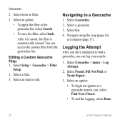
...Filter
Setup.
2. Navigating to the geocache list, select Search.
• To save the filter, select back. Navigate using the map (page 16)
or compass (page 17). Geocaches
2. Select an option:
• To apply the filter to a Geocache
1...., select Find Next Closest. • To end the logging, select Done.
22
eTrex Owner's Manual
Select Found, Did Not Find, or Needs Repair.
3.
Owner's Manual - Page 24

...be within a specified range of a compatible Garmin device.
1. Follow the on-screen instructions. Select a location.
5. Select Done.
Select Create Alarm.
3. Select Use...routes, and tracks.
Select a category.
4. Enter a radius.
7. Applications
Applications
Sharing Data
The eTrex 30 can send or receive data when connected to another compatible device. Select Share Wirelessly. 2. ...
Owner's Manual - Page 26

... the device, you can set the
time, and select Done. 3.
Turning Off GPS Select Satellite > menu > Use With GPS Off.
26
eTrex Owner's Manual Opening the Stopwatch
Select Stopwatch. Select Alarm Clock. 2.
If necessary,...toward the top of that satellite (eTrex 20/30). Select the clock numbers to set the device to the signal strength bar of the screen.
3. Select Satellite > menu.
2.
Owner's Manual - Page 27

Select a location.
4. Select Use. Select menu > Set Location On Map.
3. Applications
eTrex Owner's Manual
27 Simulating a Location Before you can simulate a location, you must turn off GPS (page 26).
1. Select Satellite > menu > Use With GPS Off.
2.
Owner's Manual - Page 28
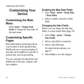
... Main Menu
Select menu > Change Item Order to change the map data fields, you can customize the data fields and dashboards of the map, compass, and trip computer. Customizing Specific Pages
Data fields display... Dashboards are a custom grouping of data fields. Enabling the Map Data Fields 1.
Select a data field to save the changes.
28
eTrex Owner's Manual Select back to customize.
3.
Owner's Manual - Page 31
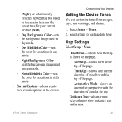
... text on the map.
Select a tone for selections in night mode.
• Screen Capture-allows you to select when to take screen captures on the device.... sets the background image used in day mode.
◦◦ Day Highlight Color-sets the color for messages, keys, turn warnings, and alarms.
1.
eTrex...
Owner's Manual - Page 55

... timeout 30 screen capture 30 settings 30 downloading geocaches 21 software 40 driving routes 37
E editing
profiles 30 routes 12 waypoints 9
eTrex Owner's Manual
elevation plot 19, 20 barometric altimeter 20 of a ...GPS signals 8, 26, 30, 47, 49, 52 turning off 26
H heading settings 34 HomePort 43
Index
hunting times 25
K keys 5, 6
L language 30 locking ring 6
M main menu
customizing 28 map ...
Similar Questions

Montana 600 How Do You Show Current Time On Map Screen
(Posted by roysVE 9 years ago)

What Is The Ft On The Satellite Screen On Garmin Etrex 10
(Posted by Zandwafra 9 years ago)


