
Garmin eTrex 10 Support Question
Garmin eTrex 10 Support Question
Find answers below for this question about Garmin eTrex 10.Need a Garmin eTrex 10 manual? We have 2 online manuals for this item!
Question posted by rayandruthpease on February 9th, 2012
Can You Enter Your Way Points Directly Into The E10
The person who posted this question about this Garmin product did not include a detailed explanation. Please use the "Request More Information" button to the right if more details would help you to answer this question.
Current Answers
Related Garmin eTrex 10 Manual Pages
Owner's Manual - Page 8

... the sky to http://www.garmin.com/aboutGPS. When the GPS bars on the backlight page (page 40) are set automatically based on , it begins acquiring satellite signals. Registering Your Device
• Go to http://my.garmin.com. • Keep the original sales receipt, or a
photocopy, in a safe place.
8
eTrex Owner's Manual
Owner's Manual - Page 9

...Mark Waypoint. 2. Select Where To? > Waypoints. 2. Select an item to edit, and select Done. Enter the new information. 5. Select Done. Select menu > Delete > Yes.
Waypoints, Routes, and Tracks
Waypoints...; To make changes to the waypoint, select an item to edit. 4. Select a waypoint. eTrex Owner's Manual
9
Creating a Waypoint You can edit a waypoint, you must create a waypoint....
Owner's Manual - Page 10

... location.
1. Using Sight 'N Go
Sight 'N Go is available on the eTrex 30. Enter the distance to the location.
4.
Select Lock Direction > Project Waypoint.
4. You can point the device at an object or in the direction, and then navigate to the object.
1. Select a unit of a location.
3.
Point the device at an object in the distance, lock in...
Owner's Manual - Page 11

... loaded on the eTrex 20 and eTrex 30, such as BirdsEye™ satellite imagery, BlueChart® g2, TOPO, and City Navigator® detailed maps. Select menu > Spell Search.
4. Enter all or part ...on your Garmin dealer. categories are available in all Where To? Detailed maps may contain additional points of interest, such as restaurants, hotels, and auto services.
1. Select Where To?.
2. Finding ...
Owner's Manual - Page 12

... the route. 4. Select Use > Select Next Point. 5.
Select a route. 3. Select Done.
12
eTrex Owner's Manual Enter the city or postal code.
Select a category. 3. Editing the Name of waypoints that leads you to your final destination. NOTE: Not all map data provides postal code searching. 4. Enter the house number. 6. Enter the street. Select Route Planner > Create...
Owner's Manual - Page 13

... route, select Remove.
6. Select back to view
additional details. Select a route. 3. While navigating a route, select
Active Route. 2. Reversing a Route 1. Select View Map. Select a point in the route to save the route. Select Reverse Route. Waypoints, Routes, and Tracks
Viewing a Route on the route, select Insert. eTrex Owner's Manual
13 Select Route Planner.
2.
Owner's Manual - Page 14

... the recorded path, including time, location, and elevation for each point. Select Record Interval. 6. NOTE: Using the Most Often interval provides the most track detail, but fills up the device memory quicker.
• Enter a time or distance, and select Done. eTrex Owner's Manual Select Record Method.
4. Recording Track Logs 1. Select an option:
•...
Owner's Manual - Page 17

... to navigate to your vehicle.
1.
Follow the turns in your destination.
• Select a location on the eTrex 20 and eTrex 30. Navigating a Driving Route Driving route navigation is using the automotive profile, the compass displays GPS heading, not magnetic heading. Before you can use the map, you must purchase and load City Navigator...
Owner's Manual - Page 18

... navigating to a destination, points to your destination is most useful if you are navigating on -screen instructions. As you are no major obstacles in that direction to the destination, the ...) provides the indication of the direction you drift from the intended course to the destination. Select Compass.
3. Begin navigation to the distance
18
eTrex Owner's Manual Follow the on...
Owner's Manual - Page 19

...
Elevation plotting is available on the course deviation indicator. Select an option.
eTrex Owner's Manual
19
To customize the elevation plot, see page 34. Details about a Point on the Plot
Select an individual point on the plot. between dots on the eTrex 30.
Select Compass. 3. By default, the elevation plot displays the elevation for...
Owner's Manual - Page 21

... an option:
• To apply the filter to a computer (page 44).
2. eTrex Owner's Manual
21
Geocaches
Filtering the Geocache List
You can apply it in .
5.
... your device to the geocache list, select Search.
• To save custom filters for hidden treasures using GPS coordinates posted online by those hiding the geocache. Go to filter.
3.
Select items to www.OpenCaching.com....
Owner's Manual - Page 23

...'s Manual
23 A chirp is available on the eTrex 30. Select Setup > Geocaches.
2.
Begin navigating to the next stage of the geocache that you are within 33 feet (10 m) of the geocache.
Select Geocaches > menu >...cache or the cache itself, select Add Comment, enter a comment, and select Done. • To enter a comment about programming a chirp, see the chirp Owner's Manual at http://www...
Owner's Manual - Page 24

.... Follow the on-screen instructions. Setting a Proximity Alarm
Proximity alarms alert you when you are within 10 feet (3 m) of a particular location.
1. Select a location.
5. Select a category.
4. Enter a radius.
7. Select Done.
Applications
Applications
Sharing Data
The eTrex 30 can share data wirelessly, you must be within a specified range of a compatible Garmin device.
1. Select...
Owner's Manual - Page 26

... necessary, select Track Up to change the view of the satellites to the signal strength bar of the screen.
3. Turning Off GPS Select Satellite > menu > Use With GPS Off.
26
eTrex Owner's Manual Select an option. If the device is off at the alarm time, the device turns on at the selected time...
Owner's Manual - Page 27

Select Use. Applications
eTrex Owner's Manual
27
Select a location.
4. Simulating a Location Before you can simulate a location, you must turn off GPS (page 26).
1. Select Satellite > menu > Use With GPS Off.
2. Select menu > Set Location On Map.
3.
Owner's Manual - Page 30

... mode.
◦◦ Mode-sets a light background (Day), a dark background
30
eTrex Owner's Manual Select a profile. 3. Select Done.
Customizing Your Device
Editing a Profile Name 1. Select Delete > Yes. note: Changing the text language does not change the language of user-entered data or map data, such as street names.
• Battery Type-allows...
Owner's Manual - Page 34

...
• Calibrate Compass-page 17.
Altimeter Settings
This function is WGS 84. sets the direction to your destination.
◦◦ Course (CDI)-the course deviation indicator displays your relationship...compass to a GPS compass when you to self-calibrate each time you turn the device on.
34
eTrex Owner's Manual The default coordinate system is available on the eTrex 30.
Select ...
Owner's Manual - Page 49
... you have strayed from your current position and elevation to Dest. eTrex Owner's Manual
49
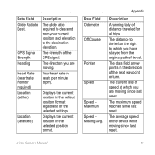
Your heart rate in the selected position format.
The strength of distance traveled for all trips.
The direction you are moving. Displays the current position in the direction of the selected settings. The average speed of travel.
The...
Owner's Manual - Page 50

... on a
destination along a
route.
50
eTrex Owner's Manual L
means turn right. Velocity Made The speed at which you are closing on your GPS position. The current time of time since ...
you must move to return to your
destination and your GPS position.
Turn
The angle of sunrise based on the route.
The direction in
degrees) between
the bearing to the route. Appendix...
Quick Start Manual - Page 7
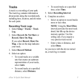
...a specified time, select Time.
5.
Select Record Method.
4.
eTrex 10 Quick Start Manual
7 Recording Track Logs 1. Select Record, Do... If you require a very precise track record.
• Enter a time or distance, and select Done.
Complete an action:...information about points along the recorded path, including time, location, and elevation for each point. Select Recording Interval....
Similar Questions

When Navigating A Route Why Doesn't The Device Find Next Way Point
(Posted by grahamfraser 8 years ago)

Storage Problem On Gps Etrex 10
When I try to store anything on my eTrex 10, I get this message appear on the screen. "There is not ...
When I try to store anything on my eTrex 10, I get this message appear on the screen. "There is not ...
(Posted by derekhill108 8 years ago)

How Do I Set Up A Garmin Etrex 10 To Work With Map Point
(Posted by jax7Sarahp 9 years ago)

Saving Way Points Using Coordinates
How do I save more than 1 way point using coordinates. 2nd entry deletes the 1st.
How do I save more than 1 way point using coordinates. 2nd entry deletes the 1st.
(Posted by pattybackus 10 years ago)