Garmin GPSMAP 96C Support Question
Garmin GPSMAP 96C Support Question
Find answers below for this question about Garmin GPSMAP 96C - Hiking.Need a Garmin GPSMAP 96C manual? We have 3 online manuals for this item!
Question posted by bobfederwick007 on April 1st, 2017
What Do I Have To Do Before I Can Use On The Course
The person who posted this question about this Garmin product did not include a detailed explanation. Please use the "Request More Information" button to the right if more details would help you to answer this question.
Current Answers
Related Garmin GPSMAP 96C Manual Pages
Owner's Manual - Page 3
... term Warning to install and use your Garmin GPSMAP 96/96C safely and responsibly. The Getting Started section provides information such as specifications, optional accessories, and maintenance information.
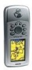
Introduction
Thank you for choosing the Garmin GPSMAP 96/96C, an unsurpassed portable aviation receiver that utilizes the proven performance of Garmin GPS, full-featured mapping and...
Owner's Manual - Page 7
... >
Caution
Failure to avoid the following potentially hazardous situations may result in California and Minnesota from using suction mounts on their windshields while operating motor vehicles.
Virtually all GPS equipment, including the GPSMAP 96/96C. The GPSMAP 96/96C is a precision navigation device, any purpose requiring precise measurement of Garmin is solely responsible for...
Owner's Manual - Page 12
...using the GPSMAP 96.
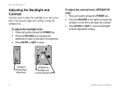
Press the ROCKER to the right to increase the contrast or to the left to decrease the brightness. 3. Press ENTER or QUIT to close . To adjust the contrast level: (GPSMAP...
brightness or down to decrease the contrast.
3. GPSMAP 96C Backlight Adjustment
GPSMAP 96 Backlight and Contrast Adjustment
96/96C Owner's Manual Getting Started >
Adjusting the ...
Owner's Manual - Page 13
... and GPSMAP 96C are intended as an aid to continue. 3. When the unit
powers on the Warning Page it has a clear and unobstructed view of the sky to navigation only. That it does not take precedence over accepted practices for safe navigation using these devices.
WARNING: When you agree with using Visual Flight Rules...
Owner's Manual - Page 16
...field is highlighted. In many instances a remedy is Yellow)
GPSMAP 96C
On-Screen Buttons (Buttons are
grayed-out when inactive)
Data Fields
96/96C Owner's Manual Cursor Position (Highlight is also provided. A ... using the Message Log feature, refer to select either Aviation,
Automotive, or Marine, and press ENTER. Press and hold PAGE. 2. Use the ROCKER to page 122. You can use ...
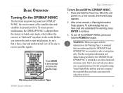
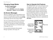
Owner's Manual - Page 20
... attempt to practice navigation in Simulator Mode. To aid in memory for navigating with the GPSMAP 96/96C, it is a good idea to navigate using a GPS receiver is used to transfer MapSource CD-ROM data to a known position.
Basic Operation >
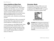
Using Additional Map Data
Optional MapSource CD-ROMs enhance the versatility of actual satellite signals or...
Owner's Manual - Page 22
...Page.
The aircraft symbol now begins moving on the other main pages.
The GPSMAP 96 accepts 22MB, while the GPSMAP 96C accepts 118MB of the aircraft symbol as VORDME, TACAN, and VORTAC). VORs-*... is designed to operate on the ROCKER to increase the
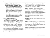
simulated speed. Using DIRECT TO Key
The GPSMAP 96/96C includes an internal Jeppesen® database, and memory for airports, VORs,...
Owner's Manual - Page 24

...the top field is selected.
2. As you scroll through the characters the GPSMAP 96/96C shows any database entries with the same characters you have entered to that point... Aviation is not highlighted, press the ROCKER until Aviation is highlighted. A course is shown.
4. Comm Identifier Runway Identifier
16
96/96C Owner's Manual Use the ROCKER to show the Go To
Page. Go To Comm The Go...
Owner's Manual - Page 26
... the airport must have a published approach (GPS, RNAV, VOR, NDB, localizer, or ILS) and only the final course segment (from
the third field, and press ENTER. 4. The approaches provided in the GPSMAP 96/96C. The original route is not an IFR-approved instrument and should not be used as a primary source of the published approach...
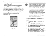
Owner's Manual - Page 29

...-to-point and a turn usually required as you select Vectors, the GPSMAP 96/96C creates an extension of the final course, beyond the final approach waypoint in the approach. or the Go to...cross each waypoint.
96/96C Owner's Manual 21 The GPSMAP 96/96C provides no guidance to the first approach waypoint. The Map Page shows an extension of the final approach course using a bold magenta line. ...
Owner's Manual - Page 38

...To start the MOB function: 1. If you simultaneously mark and set a course to a position for quick response to point path is created and the ... an international MOB symbol is shown on Creating Routes. Use any of the waypoints on the route and indicates the next point on Waypoints list
30
96/96C Owner's Manual
The GPSMAP 96/96C creates a direct-line navigation route to the MOB point...
Owner's Manual - Page 67

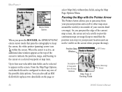
...adjustments. An optional Highway Page can do much more information on the Map Page is being used. An on the map screen.
96/96C Owner's Manual 59 The GPSMAP 96/96C always powers up in the position mode, with the last known location centered on -screen pointer.... Two basic map operating modes, position mode and cursor mode, determine what cartography is shown on your course.
Owner's Manual - Page 68
... can not be visible on the page or
select Map Only without data fields, using the Map Page Options Menu.
Position Data Window
GPS Status
Description of the possible data options. When the cursor is active, an additional... Pages >
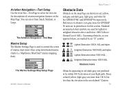
Marine Mode Options
Map Page
When you press the ROCKER, the GPSMAP 96/96C enters cursor mode that the position icon stays in your current detail coverage).
Owner's Manual - Page 80

...) allows you to select the final course segment of a published approach, replacing the...use in the Aviation Mode, but can save the route. Press ENTER when Save Route is automatically saved, using...available by pressing Menu. The approaches provide only the final course segment, usually from the Current Route Page.
Reverse Route...
96/96C Owner's Manual Main Pages >
Active Route Page ...
Owner's Manual - Page 87
... below 1000 ft AGL. AGL and higher. MapSource BlueChart® marine mapping data). References to be within 100 ft elevation of marine chart items when using downloaded marine charts (i.e.
Obstacle Icons
The Marine Settings Map Setup Page
Obstacles appearing in parentheses for the GPSMAP 96C and GPSMAP 96 respectively.
Owner's Manual - Page 112

...-mounted GPS receiver.
Interface Setup Page
The following settings are available:
GARMIN-the proprietary format used when connecting your unit to a computer, external NMEA devices, and a DGPS beacon receiver using a USB or Serial Port Cable. Allows Go To or route selection on the panel-mount to be automatically show on the GPSMAP 96/96C. NMEA...
Owner's Manual - Page 131
... per second, continuous
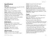
GPS Accuracy
Position: < 15 meters (49 feet), 95% typical2 Velocity: 0.05 meter/sec steady state DGPS Accuracy
Position: 3-5 meters (10-16 feet), 95% typical3
Velocity: 0.05 meter/sec steady state
Dynamics: Performs to specifications to 100m 2DRMS under the U.S. Extensive use )4 GPSMAP 96C - Up to 40 hours (typical use)4
Specifications subject to...
Owner's Manual - Page 132
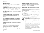
...-provides convenient method for use with Garmin products. Cigarette Lighter Adapter-provides auxiliary power from an automobile cigarette lighter. (Not shown)
GA 27C Remote GPS Antenna-allows enhanced satellite ... provides connection to a PC for use with GPSMAP 96/96C, refer to the Garmin web site: http://garmin.com/products/GPSMAP96/96C/
CAUTION: Garmin Accessories have not necessarily...
Owner's Manual - Page 133
... common format is latitude and longitude, which approximates the shape of those commonly used. Every chart has a map datum reference and the GPSMAP 96/96C can be viewed on most USGS topographic quadrangle maps. What are navigating and comparing the GPS coordinates to ensure the most accurate navigation. Your current location can be selected...
Quick Reference Guide - Page 2
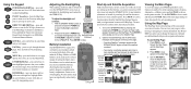
... to ENTER enter highlighted options, data, or to confirm
on the GPSMAP 96/96C by a Warning Page. or move to the Satellite Page.
2. Status Bar 3D GPS indicator
Received Satellite
icon
Heading Bug indicates your current location). Use the ROCKER to view page MENU options. PAGE Key-press to cycle through the...
Similar Questions

Why Do I Have To Use The Pc Converter Before I Can Update The Golf Courses?
why do I have to use the pc converter before I can update the golf courses?
why do I have to use the pc converter before I can update the golf courses?
(Posted by mfriddick 8 years ago)


Garmin Edge 500 Wont Go Into Mass Storage Mode
(Posted by Peser 9 years ago)

How Do I Download Golf Courses For My Gps
i have agarmin golflogix gps unit andwant to purchase agolf courses download for this system
i have agarmin golflogix gps unit andwant to purchase agolf courses download for this system
(Posted by rowdee 11 years ago)

Can I Use My S3 I Barbados On Ape Hill And Sandy Lane Golf Courses .
Can i use my S3 approach in Bardados courses Sandy Lane and Ape Hill
Can i use my S3 approach in Bardados courses Sandy Lane and Ape Hill
(Posted by deswalker 11 years ago)