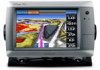
Garmin GPSMAP 740/740s Support Question
Garmin GPSMAP 740/740s Support Question
Find answers below for this question about Garmin GPSMAP 740/740s.Need a Garmin GPSMAP 740/740s manual? We have 7 online manuals for this item!
Question posted by greenislandtaxi on September 16th, 2013
Problem
my gpsmap 740s need some help when i zoom in i can see any thing on the touch screan.
Current Answers
Related Garmin GPSMAP 740/740s Manual Pages
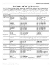
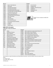
Technical Reference for Garmin NMEA 2000 Products - Page 3
...NMEA 2000 Data Type Requirements, provides a table to help you determine which NMEA 2000 sensors provide the particular ... (PGN) information for Garmin chartplotters and marine instruments as well as configuration and PGN ...GPSMAP® 4000/5000/6000/7000 Series chartplotters ◦ GPSMAP 700 Series chartplotters ◦ GPSMAP 4x1/5x1/5x6 Series chartplotters ◦ GMI™ 10 ◦ GPS...
Technical Reference for Garmin NMEA 2000 Products - Page 13
... more -precise information. Eng Dynamic 127489 - Engine Rapid 127245 - Eng Dynamic 127489 - Eng Dynamic (GPS Speed or Water Speed) Note: The Fuel Economy data type is necessary or a specific combination of data...-certified sensor provides unique information to the NMEA 2000-certified display devices (such as a GPSMAP 4000/5000 series chartplotter or a GMI 10) on the fuel speed source 127489 -...
Installation Instructions - Page 1
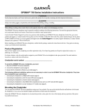
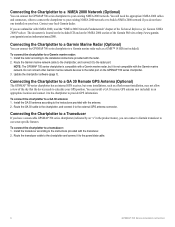
...: • Connecting the chartplotter to a NMEA 2000 network (page 6) • Connecting the chartplotter to a GA 30 remote GPS antenna (page 6). • Connecting the chartplotter to a Garmin marine radar (page 6). • Connecting the chartplotter to your GPSMAP 700 series chartplotter, confirm that the package contains the items listed on the box.
The serial number...
Installation Instructions - Page 2
...Apply marine sealant (optional).
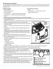
➊ GA 30 GPS antenna cable clip ➋ Power/data cable clip ➌ Garmin Marine Radar cable clip ➍ NMEA 2000 cable clip
Cable-Organization-Bracket Clip Identification
GPSMAP 700 ...to the location at least 32 in the following order to ensure that they will help to avoid any cracking in . (152-178 mm) of the template.
4.
...
Installation Instructions - Page 6
... not allow a view of the sky that the device needs to the power/data cable.
GPSMAP 700 Series Installation Instructions Route the Garmin marine network cable to the chartplotter, and connect it to calculate your existing NMEA 2000 network. Connecting the Chartplotter to the external GPS antenna connector. To connect the chartplotter to your...
Installation Instructions - Page 7
...
➍
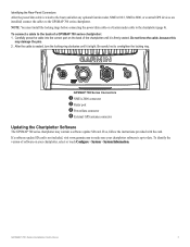
GPSMAP 700 Series Connectors
➊ NMEA 2000 connector ➋ Radar port ➌ Power/data connector ➍ External GPS antenna connector
Updating the Chartplotter Software
The GPSMAP 700 series ...card. GPSMAP 700 Series Installation Instructions
If a software update SD card is not included, visit www.garmin.com to make sure your chartplotter, select or touch Configure ...
Installation Instructions - Page 8
... × 142 × 80 mm)
Weight
2.48 lb. (1.125 kg)
Display
W × H: 6 × 3 /19 32 in . (813 mm) Distance
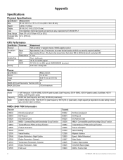
GPS Performance
Specification Parameter
Receiver
Acquisition Time
Warm Cold
Reacquisition
Update Rate
Accuracy
GPS
DGPS
Velocity
Measurement High-sensitivity 12 parallel channel, WAAS-capable receiver Approximately 1 sec. (The device is at or near...
Installation Instructions - Page 9
...) Sentence "B" BOD - GNSS Satellites in View Wind Data
GPSMAP 700 series chartplotters are NMEA 2000 certified. Recommended Minimum Specific GNSS...You can purchase complete information about National Marine Electronics Association (NMEA) format and sentences from: NMEA Seven Riggs Avenue Severna Park, MD 21146 USA www.nmea.org
GPSMAP 700 Series Installation Instructions
Global Positioning...
Installation Instructions - Page 10
... Taiwan These trademarks may not be used without the express permission of the National Marine Electronics Association.
February 2010
© 2010 Garmin Ltd. or its subsidiaries. B... products, visit the Garmin Web site at www.garmin.com. Garmin®, the Garmin logo, GPSMAP®, and AutoLocate® are registered trademarks of Garmin.
For the latest free software updates (...
Owner's Manual - Page 3
... to touch that you should select each item in order. GPSMAP 700 Series Owner's Manual
i This manual includes information for product warnings and other important information. Introduction
Introduction
WARNING See the Important Safety and Product Information guide in the product box for the following products:
• GPSMAP® 720/720s • GPSMAP 740/740s • GPSMAP...
Owner's Manual - Page 4
... Turning Off the Chartplotter 1 Initial Chartplotter Settings 2 GPS Satellite Signal Acquisition 2 Adjusting the Backlight 2 Adjusting ...Perspective 3D 15 BlueChart g2 Vision 16 Mariner's Eye 3D 17 Fish Eye 3D... Autopilot 32
Where To 33 Marine Services Destinations 33
Almanac, On...Signals 54 Adjusting the Zoom Scale on the
Radar...84 Screenshots 85 Viewing GPS Satellite Locations 85 Using...
Owner's Manual - Page 5
... Series Owner's Manual
➋ ➍
1
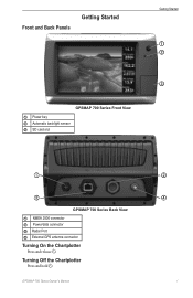
Front and Back Panels
Getting Started
Getting Started
➊ ➋
➌
GPSMAP 700 Series Front View ➊ Power key ➋ Automatic backlight sensor ➌ SD card slot
➊
➌
GPSMAP 700 Series Back View ➊ NMEA 2000 connector ➋ Power/data connector ➌ Radar Port ➍ External...
Owner's Manual - Page 6
...8226; Use the slider bar to eject the card.
➊
2
GPSMAP 700 Series Owner's Manual
Getting Started
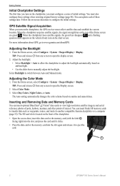
Initial Chartplotter Settings
The first time you turn on the .... You can update each of initial settings. Select Day Colors, Night Colors, or Auto. GPS Satellite Signal Acquisition
When you must configure a series of these settings when restoring original factory settings...
Owner's Manual - Page 12
...6. Select Navigation Chart Setup or Fishing Chart Setup.
8
GPSMAP 700 Series Owner's Manual Select Navigation Chart, Fishing Chart, Perspective 3D, or Mariner's Eye 3D. 3.
Select Navigation Chart Setup or Fishing ...to use GPS heading data. Changing the Map Zoom Detail You can view details about Navaids From the Navigation chart, the Fishing chart, Perspective 3D, or Mariner's Eye ...
Owner's Manual - Page 18
..., to all 3D chart views, to 2.0 mi.).
14
GPSMAP 700 Series Owner's Manual
The Fishing chart is used only ...AIS Vessel You can view the AIS signal status, MMSI, GPS speed, GPS heading, and other information that 3D chart view. Viewing ...Select Navigation Chart, Fishing Chart, Perspective 3D, or Mariner's Eye 3D. 3. Select AIS Vessel. Touch an AIS vessel. 4. From the Home screen, select...
Owner's Manual - Page 20
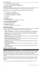
You can use the data card only on BlueChart g2 Vision-compatible Garmin GPS units or Garmin HomePort™. Select Done. Showing Other Vessels See "Configuring... g2 Vision has the following features:
• Mariner's Eye 3D (page 17)-provides a view from exposure to sun and rain to prevent damage to the information on or off.
16
GPSMAP 700 Series Owner's Manual BlueChart g2 Vision data...
Owner's Manual - Page 54

... 3D. From the Home screen, select Configure > System > GPS. 2. Select Navigation Chart, Fishing Chart, Perspective 3D, or Mariner's Eye 3D. 3. Select Show Compass Tape. Other Vessels You can calibrate that appears
using a trail (page 82). • Select AIS Alarm to get the message, contact Garmin Product Support.
50
GPSMAP 700 Series Owner's Manual
Owner's Manual - Page 75
... fishfinders: • GPSMAP 720s • GPSMAP 740s • GPSMAP 750s
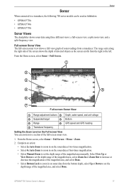
Sonar Views
The chartplotter shows sonar data using three different views: a full-screen view, a split-zoom view, and a split...10124; Suspended target
➍ Bottom
➎ Range
➏ GPS speed and GPS heading
➐ Transducer frequency
Setting the Zoom Level on sonar data from the bottom depth, select Up or ...
Owner's Manual - Page 94
... arrival 51 clock 51 collision 12, 14, 58 deep water 77 fish 77 GPS accuracy 52 navigation 51 off course 51 shallow water 77 sonar 77 system 51 ...
90
BlueChart g2 Vision aerial photos 11 chart symbols 5 data cards 16 Fish Eye 3D 18 Mariner's Eye 3D 17 POIs 21
bridging, output 88 brightness, display 2
C celestial information 38 changing...suspended targets 19 tracks 19
GPSMAP 700 Series Owner's Manual
Owner's Manual - Page 95
...6 panning 5 roses 11 satellite imagery 9, 19 tide stations 7 world map 9 zoom detail 8
fish symbols 19, 75 front-of-boat offset 69 front panel 1 ... type 39 Go To 26, 33 GPS accuracy alarm 52 performance 84 signals 2 GPS performance 84 grid north 47 guard zone... from main menu 3 deleting 28 from VHF radio 80 Mariner's Eye 3D AIS 15 data bars 48 hazard colors 17 lane...GPSMAP 700 Series Owner's Manual
91
Similar Questions

How Do I Go Into Simulation Mode On A Garmin Marine Gps Modle741xs
how do I use simulation mode on a garmin 741xs marine ver
how do I use simulation mode on a garmin 741xs marine ver
(Posted by Curthupp 6 years ago)

What Cabling Is Required With The Garman Gpsmap 740s Radar
(Posted by red1harry 9 years ago)

How Do I Do An Automatic Boat Route? Have Garmin 740s Gpsmap With G2 Vision Card
(Posted by Anonymous-115411 10 years ago)

Problem With Garmin Gpsmap 2006 C
Hello, I have this unit 2 years and i didn't have any problems. 6 months ago, for the first time it...
Hello, I have this unit 2 years and i didn't have any problems. 6 months ago, for the first time it...
(Posted by georgempax 11 years ago)