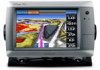
Garmin GPSMAP 740/740s Support Question
Garmin GPSMAP 740/740s Support Question
Find answers below for this question about Garmin GPSMAP 740/740s.Need a Garmin GPSMAP 740/740s manual? We have 7 online manuals for this item!
Question posted by dedwa on May 9th, 2014
How To Use Garmin 740s
The person who posted this question about this Garmin product did not include a detailed explanation. Please use the "Request More Information" button to the right if more details would help you to answer this question.
Current Answers
Related Garmin GPSMAP 740/740s Manual Pages
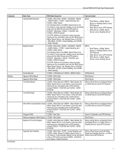
Technical Reference for Garmin NMEA 2000 Products - Page 3
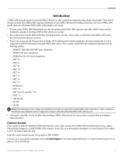
... and a list of NMEA 2000specific data used with Garmin NMEA 2000-certified displays and sensors.
&#...Garmin chartplotters and marine instruments as well as configuration and PGN information for the following products: ◦ GPSMAP® 4000/5000/6000/7000 Series chartplotters ◦ GPSMAP 700 Series chartplotters ◦ GPSMAP 4x1/5x1/5x6 Series chartplotters ◦ GMI™ 10 ◦ GPS...
Technical Reference for Garmin NMEA 2000 Products - Page 13
...Garmin Chartplotter and GPS Antenna
Garmin Chartplotter and GPS Antenna
Garmin Chartplotter Garmin Chartplotter and GPS Antenna Garmin Chartplotter and GPS Antenna Garmin Chartplotter and GPS Antenna Garmin Chartplotter and GPS Antenna Heading Sensor GPS... 129284 - Refer to the NMEA 2000-certified display devices (such as a GPSMAP 4000/5000 series chartplotter or a GMI 10) on the NMEA 2000 network....
Technical Reference for Garmin NMEA 2000 Products - Page 14
...Heading Sensor
130306 - Vessel Heading, and 128259 - Nav Data
Garmin Chartplotter and GPS Antenna
129026 - COG/SOG and 129029 - GNSS Position GPS Antenna
129026 - COG/SOG and 129029 - Envir Param
130312 ... Speed Sensor are not present, a less-accurate reading can be calculated using only the Wind Sensor and GPS antenna [130306 - Water Speed
(If a Heading Sensor and Water Speed...
Technical Reference for Garmin NMEA 2000 Products - Page 15
... Speed (If a Water Speed Sensor is not present, a less-accurate reading can be calculated using a GPS antenna instead [129026 - GNSS Position])
Either a Wind Sensor and both Water Speed and Heading Sensors, or a Wind Sensor and a GPS Antenna
Technical Reference for Garmin NMEA 2000 Products 11 Wind Data, 129026 - Vessel Heading, and 128259 - Wind Data...
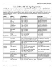
Technical Reference for Garmin NMEA 2000 Products - Page 22
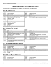
GPS 17x (GPS Antenna)
Transmit
Receive
059392 060928 126208 126464 126992 126996 129025 129026 129029..., Engine
Receive 059392 059904 060928 126208 127489 127497 127505
127505
Fluid Level (when calibrated using a Garmin chartplotter or marine instrument)
GRA 10 (Garmin Rudder Angle Adapter)
Transmit
Receive
059392
ISO Acknowledgment
059392
060928
ISO Address Claim
059904
126208...
Technical Reference for Garmin NMEA 2000 Products - Page 28
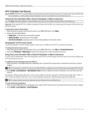
... Information With a Garmin Chartplotter or Marine Instrument
Caution: The Garmin chartplotter or marine instrument must specify the amount of your NMEA 2000 device, select Menu > Fuel Economy Source. 2. Choose from the GFS 10: 1. Select either GPS Speed or Water Speed to specify which speed sensor is used on the fuel-flow rate. For example, entering five...
XM Supplement - Page 2
... updates and supplemental information concerning the use and operation of Garmin. Information in any revision hereto is a trademark of such changes or improvements. Garmin®, the Gamin logo, GPSMAP®, BlueChart®, and g2 Vision® are registered trademarks of Garmin Ltd. © 2010 Garmin Ltd. or its subsidiaries
Garmin International, Inc. 1200 East 151st Street...
Installation Instructions - Page 1
... GPSMAP 700 series chartplotter. Notice When drilling or cutting, always check what is located on a sticker on the opposite side of two methods. Before installing your convenience: • Connecting the chartplotter to a NMEA 2000 network (page 6) • Connecting the chartplotter to a GA 30 remote GPS antenna (page 6). • Connecting the chartplotter to a Garmin marine...
Installation Instructions - Page 2
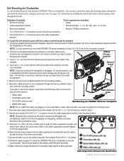
... place to install the bail-mount bracket.
Apply marine sealant (optional).
➊ GA 30 GPS antenna cable clip ➋ Power/data cable clip ➌ Garmin Marine Radar cable clip ➍ NMEA 2000 cable clip
Cable-Organization-Bracket Clip Identification
GPSMAP 700 Series Installation Instructions Bail Mounting the Chartplotter Use the included bracket to the mounting surface...
Installation Instructions - Page 6
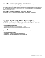
... to a GA 30 Remote GPS Antenna (Optional)
The GPSMAP 700 series chartplotter has an internal GPS receiver, but it to the chartplotter to a Garmin marine radar: 1. To connect the chartplotter to the radar port on the GPSMAP 700 series chartplotter. 3. If you can connect a Garmin transducer to use sonar-specific features.
Route the Garmin marine network cable to the chartplotter...
Installation Instructions - Page 10
... trademarks may not be used without the express permission of Garmin Ltd. February 2010
© 2010 Garmin Ltd. GMR™ is a trademark of Garmin. or its subsidiaries, registered in Taiwan B
Printed in the USA and other countries. Garmin®, the Garmin logo, GPSMAP®, and AutoLocate® are registered trademarks of the National Marine Electronics Association. For the...
Owner's Manual - Page 3
...use your finger to touch that you should touch Charts and then touch Navigation Chart.
Introduction
Introduction
WARNING See the Important Safety and Product Information guide in the product box for the following products:
• GPSMAP® 720/720s • GPSMAP 740/740s • GPSMAP... you should select each item in order. GPSMAP 700 Series Owner's Manual
i Small arrows ...
Owner's Manual - Page 4
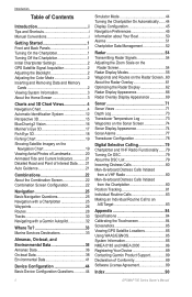
... Off the Chartplotter 1 Initial Chartplotter Settings 2 GPS Satellite Signal Acquisition 2 Adjusting the Backlight 2 ...3D 15 BlueChart g2 Vision 16 Mariner's Eye 3D 17 Fish Eye ...with a Garmin Autopilot 32
Where To 33 Marine Services Destinations...GPS Satellite Locations 85 Using WAAS/EGNOS 85 System Information 85 NMEA 0183 and NMEA 2000 86 Registering Your Device 89 Contacting Garmin...
Owner's Manual - Page 6
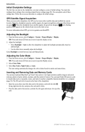
... changes the color scheme based on ambient light. • Use the slider bar to adjust the backlight automatically, based on... on -screen directions to eject the card.
➊
2
GPSMAP 700 Series Owner's Manual Follow the on the front of initial...2.
For more information about GPS, go to switch between Auto and Manual mode. Select Backlight to www.garmin.com/aboutGPS. You can ...
Owner's Manual - Page 7
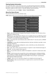
...33).
• Radar-sets up and shows radar (only available if the chartplotter is connected to a Garmin marine radar) (page 54).
• Weather-(North America only) sets up and shows various weather parameters, ... is available if you use the Home screen to access all other boats, and gauges (page 36).
• Mark-marks, edits, or deletes your present location as a GPSMAP 720s) (page 71)....
Owner's Manual - Page 12
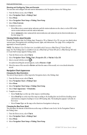
...of navigation is available only if you use GPS heading data. From the Home screen, select Charts. 2. The Fishing chart is available if you use a BlueChart g2 Vision SD card (...Chart, Fishing Chart, Perspective 3D, or Mariner's Eye 3D. 3. Select a navaid with the cursor ( ). Select Navigation Chart Setup or Fishing Chart Setup.
8
GPSMAP 700 Series Owner's Manual Select Chart Appearance ...
Owner's Manual - Page 20
....
In low-humidity environments, you to detailed marine charting, BlueChart g2 Vision has the following features:
• Mariner's Eye 3D (page 17)-provides a view from the data card to your chartplotter. You can use the data card only on or off.
16
GPSMAP 700 Series Owner's Manual
Using Waypoints and Tracks See "Waypoints" (page 26...
Owner's Manual - Page 54

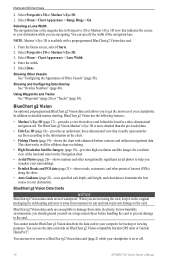
...speed of your boat over a short period of Other Vessels Note: The Mariner's Eye 3D chart is available if you use a BlueChart g2 Vision SD card or a BlueChart g2 SD card, or...of AIS targets (page 12). • Select DSC List to get the message, contact Garmin Product Support.
50
GPSMAP 700 Series Owner's Manual If the wheel turns freely, check the cable connections. Information about ...
Owner's Manual - Page 75
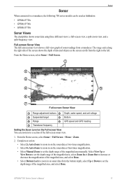
... unit voltage
➌ Suspended target
➍ Bottom
➎ Range
➏ GPS speed and GPS heading
➐ Transducer frequency
Setting the Zoom Level on the sonar data at ... a section of detected objects as fishfinders: • GPSMAP 720s • GPSMAP 740s • GPSMAP 750s
Sonar Views
The chartplotter shows sonar data using three different views: a full-screen view, a split...
Quick Reference Guide - Page 2

...Done. When using the Go To feature. Review the course indicated by touching Mark at a Different Location 1. Go to open the Display screen.
2. Garmin®, the Gamin logo, GPSMAP®, BlueChart...time until you want to a Marine Services Destination
CAUTION The Auto Guidance feature of the heading line.
4.
Navigating to a Marine Service
Navigating to navigate. Carefully ...
Similar Questions

How Do I Go Into Simulation Mode On A Garmin Marine Gps Modle741xs
how do I use simulation mode on a garmin 741xs marine ver
how do I use simulation mode on a garmin 741xs marine ver
(Posted by Curthupp 6 years ago)


How Do I Do An Automatic Boat Route? Have Garmin 740s Gpsmap With G2 Vision Card
(Posted by Anonymous-115411 10 years ago)