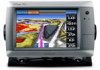
Garmin GPSMAP 740/740s Support Question
Garmin GPSMAP 740/740s Support Question
Find answers below for this question about Garmin GPSMAP 740/740s.Need a Garmin GPSMAP 740/740s manual? We have 7 online manuals for this item!
Question posted by hal90monch on March 14th, 2014
How To Navigate A Route With A Garmin 740s
The person who posted this question about this Garmin product did not include a detailed explanation. Please use the "Request More Information" button to the right if more details would help you to answer this question.
Current Answers
Related Garmin GPSMAP 740/740s Manual Pages
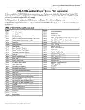
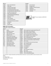
Technical Reference for Garmin NMEA 2000 Products - Page 13
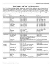
... Fuel Economy
Navigation Information
(Continued...as a GPSMAP 4000/5000 series chartplotter or a ... 127488 - Route 129284 - General...Garmin Chartplotter and GPS Antenna
Garmin Chartplotter and GPS Antenna
Garmin Chartplotter Garmin Chartplotter and GPS Antenna Garmin Chartplotter and GPS Antenna Garmin Chartplotter and GPS Antenna Garmin Chartplotter and GPS Antenna Heading Sensor GPS...
Technical Reference for Garmin NMEA 2000 Products - Page 14
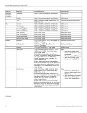
...Data Type Requirements
Category Navigation Information (continued)
Trip
Weather
Data Type GPS Speed
Position Turn
Odometer Trip Odometer Average GPS Speed Maximum GPS Speed Water Odometer Water...Sensor
(Continued)
10
Technical Reference for Garmin NMEA 2000 Products Nav Data
Garmin Chartplotter and GPS Antenna
129026 - COG/SOG and 129029 - GNSS Position GPS Antenna
128259 - Water Speed
(If...
Technical Reference for Garmin NMEA 2000 Products - Page 15
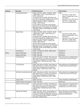
...Wind Sensor and both Water Speed and Heading Sensors, or a Wind Sensor and a GPS Antenna
Technical Reference for Garmin NMEA 2000 Products 11 Wind Data, 129026 - Wind Data, 129026 - Wind Data...Wind Data
Wind Sensor
Apparent Wind Angle
130306 - Wind Data and 128259 - Nav Data
Garmin Chartplotter and GPS Antenna
Maximum Apparent Wind Speed 130306 - Vessel Heading, and 128259 - COG/SOG and ...
Technical Reference for Garmin NMEA 2000 Products - Page 17
...All other PGN numbers follow the NMEA 2000 standard. All Garmin NMEA 2000 devices use the proprietary PGN numbers 126720 and 61184...Garmin NMEA 2000-certified display devices. GPSMAP 6000/7000 Series Chartplotters
Receive
059392 ISO Acknowledgment
059904 ISO Request
060928 ISO Address Claim
126208 NMEA - Rapid Update GNSS Position Data Cross Track Error Navigation Data Navigation Route...
XM Supplement - Page 2
... other countries. Except as expressly provided herein, no part of this manual may not be used without notice.
Garmin®, the Gamin logo, GPSMAP®, BlueChart®, and g2 Vision® are registered trademarks of Garmin. or its products and to make changes in this manual onto a hard drive or other electronic storage...
Installation Instructions - Page 2
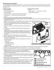
... a clearance-counter bore through the mounting surface.
7. Apply marine sealant (optional).
➊ GA 30 GPS antenna cable clip ➋ Power/data cable clip ➌ Garmin Marine Radar cable clip ➍ NMEA 2000 cable clip
Cable-Organization-Bracket Clip Identification
GPSMAP 700 Series Installation Instructions You can route cables from under the mounting surface through the...
Installation Instructions - Page 6
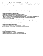
... a GA 30 remote GPS antenna (not included) in the product name), you are unfamiliar with the transducer. 2. The document is compatible with a Garmin marine radar, but some installations, such as a GMR™ 18 HD (not included). To connect the chartplotter to the radar port on the GPSMAP 700 series chartplotter. 3. Route the Garmin marine network cable to...
Installation Instructions - Page 9
...GPVTG GPWPL GPXTE PGRME PGRMM PGRMZ SDDBT SDDPT SDMTW SDVHW
APB - Latitude/Longitude GSA - Routes VTG - Estimated error M - Altitude DBT - Depth Below Transducer DPT - Water ...Navigation Data Navigation - GNSS Satellites in View Wind Data
GPSMAP 700 series chartplotters are NMEA 2000 certified. Water Speed and Heading
You can purchase complete information about National Marine...
Owner's Manual - Page 4
...Off the Chartplotter 1 Initial Chartplotter Settings 2 GPS Satellite Signal Acquisition 2 Adjusting the Backlight 2...Navigation Chart 4 Automatic Identification System 12 Perspective 3D 15 BlueChart g2 Vision 16 Mariner...Navigation 25 Basic Navigation Questions 25 Navigation with a Chartplotter 25 Waypoints 26 Routes 28 Tracks 30 Navigating with a Garmin Autopilot 32
Where To 33 Marine...
Owner's Manual - Page 7
...the system software or to access the Navigation Chart, Perspective 3D, Mariner's Eye 3D, Fish Eye 3D, the Fishing chart, and Radar Overlay. See the GPSMAP 700 Series Weather® and XM ...page 27).
• Where To?-provides navigation features (page 33).
• Radar-sets up and shows radar (only available if the chartplotter is connected to a Garmin marine radar) (page 54).
• Weather-(...
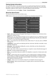
Owner's Manual - Page 8

... 3D-shows a view from supplemental maps, if available.
The bar under
4
GPSMAP 700 Series Owner's Manual Note: Mariner's Eye 3D and Fish Eye 3D chart views are available on the map. ...a BlueChart g2 Vision SD card (page 16). Navigation Chart
Use the Navigation chart to plan your boat for a visual navigation aid (page 15). • Mariner's Eye 3D-shows a detailed, three‑dimensional...
Owner's Manual - Page 20
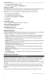
... Mariner's Eye 3D is on BlueChart g2 Vision-compatible Garmin GPS units or Garmin HomePort...GPSMAP 700 Series Owner's Manual Charts and 3D Chart Views
2. From the Home screen, select Charts. 2. Select Menu > Chart Appearance > Lane Width. 4. Showing and Configuring Data Overlay See "Overlay Numbers" (page 48). BlueChart g2 Vision Data Cards
NOTICE BlueChart g2 Vision data cards are navigating...
Owner's Manual - Page 30
...clearance.
From the Home screen, select Charts. 2. Select Navigation Chart or Fishing Chart.
26
GPSMAP 700 Series Owner's Manual Use visual sightings and steer to ...corrected course may be using Auto
Guidance. Select Navigate To > Guide To. 3.
Creating and Following a New Route Using Route To See "Creating and Navigating a Route from Your Present Location" (page 28). Follow ...
Owner's Manual - Page 36
...
When you start navigation (Go To, Route To, or Guide To), if you are connected through a National Marine Electronics Association (NMEA) 2000 network to a compatible Garmin autopilot (such as the GHP™ 10), you are prompted to enter the maximum error allowed from your course. Select Change to engage the autopilot.
32
GPSMAP 700 Series...
Owner's Manual - Page 49
...GPS position.
1. GPSMAP 700 Series Owner's Manual
45 Select a language. Configuring Route Turn Transitions You can set when the chartplotter makes audible sounds.
1. For straighter routes...Line Configurations You can improve autopilot accuracy.
1. From the Home screen, select Configure > Navigation > Route Labels. 2. From the Home screen, select Configure > System > Language. 2. Complete an...
Owner's Manual - Page 50
... or more familiar destinations that require navigation through a narrow waterway.
46
GPSMAP 700 Series Owner's Manual Select Done.
To ensure that area. Select a destination that you selected Near or Far in that the Auto Guidance line is placed the appropriate distance from the Home screen, select Configure > Navigation > Auto Guidance > Shoreline Distance > Far...
Owner's Manual - Page 54

... log of Other Vessels Note: The Mariner's Eye 3D chart is not registering...the message, contact Garmin Product Support.
50
GPSMAP 700 Series Owner...'s Manual Other Vessels You can calibrate that speed-sensing device.
1. Select OK, and safely increase the boat speed. From the Home screen, select Configure > System > GPS. 2.
Complete an action: • Select Navigation...
Owner's Manual - Page 84
... start a Williamson's turn to the man-overboard point. See "Navigating to it (page 27).
80
GPSMAP 700 Series Owner's Manual Deleting a DSC Call Report See "Deleting a Position Report" (page 81).
Man-Overboard Distress Calls Initiated from your radio, your Garmin chartplotter is connected to a Garmin NMEA 2000-compatible radio, and you initiate a man-overboard...
Owner's Manual - Page 95
... 63 radar type 63 side lobes 64 sonar 76 Garmin Product Support 89 gauges analog 39 digital 39 engine 38...40 type 39 Go To 26, 33 GPS accuracy alarm 52 performance 84 signals 2 GPS performance 84 grid north 47 guard zone ...47 man overboard
creating from a navigation screen 27
creating from main menu 3 deleting 28 from VHF radio 80 Mariner's Eye 3D AIS 15 data bars...GPSMAP 700 Series Owner's Manual
91
Quick Reference Guide - Page 2

... From the Home screen, select Mark.
Navigating to a Marine Service
Navigating to a Marine Services Destination
CAUTION The Auto...preprogrammed BlueChart g2 Vision data card. 1. Garmin®, the Gamin logo, GPSMAP®, BlueChart®, and g2 Vision...Route To.
• Select Guide To to the end of the heading line for additional documentation and information.
Go to navigate...
Similar Questions

How Do I Go Into Simulation Mode On A Garmin Marine Gps Modle741xs
how do I use simulation mode on a garmin 741xs marine ver
how do I use simulation mode on a garmin 741xs marine ver
(Posted by Curthupp 6 years ago)

How To Navigate To The Built In Fishing Map Spots In The Garmin 740s
(Posted by mrh6Surgi 9 years ago)

How Do I Do An Automatic Boat Route? Have Garmin 740s Gpsmap With G2 Vision Card
(Posted by Anonymous-115411 10 years ago)

541s Marine Gps. Depth Not Reading Out.
Depth has been working since installed. Now blank. Is there an on off control for this that may have...
Depth has been working since installed. Now blank. Is there an on off control for this that may have...
(Posted by therad50 11 years ago)