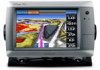
Garmin GPSMAP 740/740s Support Question
Garmin GPSMAP 740/740s Support Question
Find answers below for this question about Garmin GPSMAP 740/740s.Need a Garmin GPSMAP 740/740s manual? We have 7 online manuals for this item!
Question posted by CANES61662 on September 8th, 2014
Gps 740s
Entered Waypoints Are Not Right Tryed Several Numbers Still Wont Find A Spot Had A 441s Used Same Numbers Cant Find My Spots Do They Need Calibrated Or Something
Current Answers
Related Garmin GPSMAP 740/740s Manual Pages
Technical Reference for Garmin NMEA 2000 Products - Page 3
... Parameter Group Number (PGN) information for Garmin chartplotters and marine instruments as well as configuration and PGN information for Garmin NMEA 2000 sensors. Use this checklist ... products: ◦ GPSMAP® 4000/5000/6000/7000 Series chartplotters ◦ GPSMAP 700 Series chartplotters ◦ GPSMAP 4x1/5x1/5x6 Series chartplotters ◦ GMI™ 10 ◦ GPS 17x ◦ GFS...
Technical Reference for Garmin NMEA 2000 Products - Page 13
... 130576 - Eng Dynamic 127489 - Eng Dynamic (GPS Speed or Water Speed) Note: The Fuel Economy...Waypoint Off Course Desired COG Heading Course Over Ground
PGN Data Required 127489 - For more -precise information. Engine Rapid 127488 - COG/SOG, 129029 - Eng Dynamic 127488 - Eng Dynamic 127489 - Engine Rapid 127245 - Refer to the NMEA 2000-certified display devices (such as a GPSMAP...
Technical Reference for Garmin NMEA 2000 Products - Page 27

...certified sensors each have moved the boat many miles without using the GPS 17x, for example, you can force the GPS 17x to re-initialize and find your current position.
...information. Select Config > Auto Locate. 3. While viewing the NMEA 2000 configuration menu, select the GPS 17x device. 2. For convenience, this section contains the configuration information for Garmin NMEA 2000 Products...
Technical Reference for Garmin NMEA 2000 Products - Page 34

... Garmin NMEA 2000 Products Select an option:
• For most Garmin chartplotters, select Review > Level Calibration > Add Calibration Point. • For other Garmin marine devices, select Config > Tank Number. 3. Calibrating the Fluid Level To use the GFL 10 adapter, you must calibrate the fluid level of Live Well and the error message appears, you must assign each...
Technical Reference for Garmin NMEA 2000 Products - Page 38

... on your Garmin marine instrument, the specific configuration options may not be displayed on the version of the temperature data as defined in miles per hour, followed by Done. Enter the following table, followed by Done. After the command, enter a positive decimal number that the bait well is not displayed: To use the GST 10...
Technical Reference for Garmin NMEA 2000 Products - Page 39

...a positive or negative decimal number, followed by Done. 5. Select an option:
• For most Garmin chartplotters, select Review > Generic Config. • For other Garmin marine devices, select Config > Factory Defaults. 3.
Enter the following command: "INSTANCE=" 4. After the command, enter a positive decimal number, followed by Done. From the NMEA 2000 Devices list, select...
XM Supplement - Page 14
...Supplement Note: To use XM Satellite Radio features, you must have a subscription to XM Satellite Radio, and you have subscribed to enter an XM channel number manually. From ...the Home screen, select Weather > Weather Subscription. Complete one or more actions:
• Select Marine > On. • Select Tornado ...
Installation Instructions - Page 1
... GPS antenna (page 6). • Connecting the chartplotter to a Garmin marine ...need the appropriate fasteners, tools, and mounts listed in Taiwan garmin.com/support, or contact Garmin USA by phone at most marine dealers. Keep the original sales receipt, or a photocopy, in a safe place. by completing our online registration today.
Chartplotter serial number:
To install the GPSMAP...
Installation Instructions - Page 2
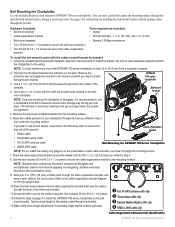
... power/data or radar cable until after you are tightened.
5. Apply marine sealant (optional).
➊ GA 30 GPS antenna cable clip ➋ Power/data cable clip ➌ Garmin Marine Radar cable clip ➍ NMEA 2000 cable clip
Cable-Organization-Bracket Clip Identification
GPSMAP 700 Series Installation Instructions
Place the cable-organization bracket around the...
Installation Instructions - Page 6
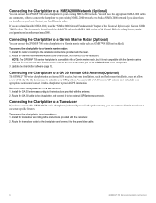
... (Optional)
You can connect the GPSMAP 700 series chartplotter to a Garmin marine radar such as a flush-mount-installation, may not allow a view of the sky that the device needs to calculate your boat. Route the GA 30 cable to the chartplotter, and connect it to the external GPS antenna connector. Route the transducer cable...
Owner's Manual - Page 3
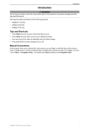
...Conventions
In this manual, when you are instructed to select an item, use your finger to select it. GPSMAP 700 Series Owner's Manual
i
For example, if you see "select...or off. Small arrows (>) in the product box for the following products:
• GPSMAP® 720/720s • GPSMAP 740/740s • GPSMAP 750/750s
Tips and Shortcuts
• Select Home from any screen to return to the ...
Owner's Manual - Page 4
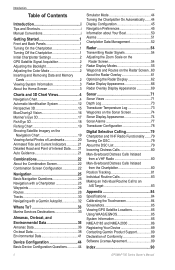
... the Chartplotter 1 Initial Chartplotter Settings 2 GPS Satellite Signal Acquisition 2 Adjusting the Backlight...15 BlueChart g2 Vision 16 Mariner's Eye 3D 17 Fish...Waypoints 26 Routes 28 Tracks 30 Navigating with a Garmin Autopilot 32
Where To 33 Marine...Modes 55 Waypoints and ...Log 73 Waypoints on the...Calibrating the Touchscreen 84 Screenshots 85 Viewing GPS Satellite Locations 85 Using...
Owner's Manual - Page 12
...
8
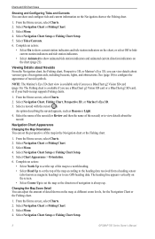
GPSMAP 700 Series Owner's Manual Select Navigation Chart or Fishing Chart. 3. The Fishing chart is available if you use a ... the direction of navigation is available only if you use GPS heading data.
Select Navigation Chart or Fishing Chart.... cursor ( ). Select Chart Appearance > Orientation. 6. Note: The Mariner's Eye 3D chart view is always up. Changing the Map Zoom ...
Owner's Manual - Page 18
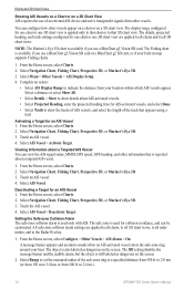
...Mariner's Eye 3D. 3.
Activating a Target for one chart or one 3D chart view are applied to all charts, to all 3D chart views, to 2.0 mi.).
14
GPSMAP...Heading, enter the projected ...Mariner's Eye 3D. 3. Deactivating a Target for one chart or one 3D chart view is used...GPS speed, GPS heading, and other vessels. Complete an action:
• Select AIS Display Range to that appears using...
Owner's Manual - Page 20
... Tracks See "Waypoints" (page 26) or "Tracks" (page 30).
You can use the data card only on the Navigation chart.
• Aerial Photos (page 20)-shows marinas and other points of the land and water on BlueChart g2 Vision-compatible Garmin GPS units or Garmin HomePort™. Select Perspective 3D or Mariner's Eye 3D...
Owner's Manual - Page 54

... Menu > Other Vessels > AIS Display Setup. 4.
Other Vessels You can calibrate that appears
using a trail (page 82). • Select AIS Alarm to get the message, contact Garmin Product Support.
50
GPSMAP 700 Series Owner's Manual Select Navigation Chart, Fishing Chart, Perspective 3D, or Mariner's Eye 3D. 3.
Information about other DSC contacts you continue to...
Owner's Manual - Page 75
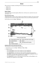
...along the right side of the screen shows the depth of detected objects as fishfinders: • GPSMAP 720s • GPSMAP 740s • GPSMAP 750s
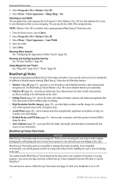
Sonar Views
The chartplotter shows sonar data using three ... unit voltage
➌ Suspended target
➍ Bottom
➎ Range
➏ GPS speed and GPS heading
➐ Transducer frequency
Setting the Zoom Level on the sonar data at...
Owner's Manual - Page 90
...port to use when connecting your boat. Configuring NMEA 0183 Output Sentences You can adjust the number of digits ... Two Digits, Three Digits, or Four Digits.
86
GPSMAP 700 Series Owner's Manual
Select a setting: Route, System... Select NMEA High Speed to the right of the decimal point for transmission ...entered.
1.
From the Home screen, select Configure > Communications > NMEA 0183 Setup. ...
Owner's Manual - Page 94
... 12, 14, 58 deep water 77 fish 77 GPS accuracy 52 navigation 51 off course 51 shallow water ... photos 11 chart symbols 5 data cards 16 Fish Eye 3D 18 Mariner's Eye 3D 17 POIs 21
bridging, output 88 brightness, display 2...configure, button 3 contact information 89 coordinate systems 47 courses 26, 28 create waypoint 6, 27, 60, 74, 81 cross talk 63, 66 cruising mode ...GPSMAP 700 Series Owner's Manual
Owner's Manual - Page 95
... alarms 39 trip 40 type 39 Go To 26, 33 GPS accuracy alarm 52 performance 84 signals 2 GPS performance 84 grid north 47 guard zone 57 Guide To 26... data bars 48 depth shading 10 heading line 9 land-based POIs 11 light sectors 11 marine service points 11 navaid symbols 10 object information 6 orientation 8 panning 5 photo points 11... radar 61 overlay numbers 48
GPSMAP 700 Series Owner's Manual
91
Similar Questions


How To Change Engine Screen On My Garmin 740 Gps
(Posted by diandy 10 years ago)
How Do I Do An Automatic Boat Route? Have Garmin 740s Gpsmap With G2 Vision Card
(Posted by Anonymous-115411 10 years ago)

How Can I Add New Waypoints To A Garmin 440s With Written Coordinates?
I sold my old Garmin GPS but wrote the locations of all my waypoints in paper. I bought a Garmin 440...
I sold my old Garmin GPS but wrote the locations of all my waypoints in paper. I bought a Garmin 440...
(Posted by enriqueluismedina 11 years ago)

My New Gpsmap 740 Displays Inaccurate Gps Heading Information. Cause?
(Posted by Kirkehasson 11 years ago)