Owner's Manual
Page 21
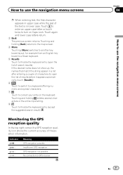
... entering text, the first character appears in upper case while the rest of search results). Monitoring the GPS reception quality In the top right corner, the GPS reception quality icon shows the current accuracy of results before it appears automatically, touch [Results]). 6 Touch... keyboard to a Greek keyboard. 5 Results Touch to correct your entry on Caps Lock. Indicator : : : : Meaning GPS navigation possible Insufficient GPS navigation GPS navigation not possible No connection to GPS receiver Chapter 04 En 21 How to finalize the keyboard entry (accept the suggested search result).
... entering text, the first character appears in upper case while the rest of search results). Monitoring the GPS reception quality In the top right corner, the GPS reception quality icon shows the current accuracy of results before it appears automatically, touch [Results]). 6 Touch... keyboard to a Greek keyboard. 5 Results Touch to correct your entry on Caps Lock. Indicator : : : : Meaning GPS navigation possible Insufficient GPS navigation GPS navigation not possible No connection to GPS receiver Chapter 04 En 21 How to finalize the keyboard entry (accept the suggested search result).
Owner's Manual
Page 24
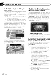
...on page 19. 2 If the current street is displayed below to Searching for useful Points Of Interest (POI) nearby on page 35. When GPS position is available, the arrow mark is displayed in the top right corner of the screen to open the "Where Am I ?]. Latitude and...known position. Checking the detailed information about the last known position if GPS reception is transparent. p The arrow mark appears in WGS84 format) ! When there is no GPS position, the arrow mark is not available) from the GPS receiver - Follow the steps below the arrow mark (current position), touch ...
...on page 19. 2 If the current street is displayed below to Searching for useful Points Of Interest (POI) nearby on page 35. When GPS position is available, the arrow mark is displayed in the top right corner of the screen to open the "Where Am I ?]. Latitude and...known position. Checking the detailed information about the last known position if GPS reception is transparent. p The arrow mark appears in WGS84 format) ! When there is no GPS position, the arrow mark is not available) from the GPS receiver - Follow the steps below the arrow mark (current position), touch ...
Owner's Manual
Page 46
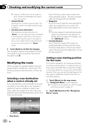
... key to append the newly selected destination at the end of the current route. Modifying the route When navigation is much better than the current GPS position. 1 Touch [Menu] on the "Navigation Menu" screen. ! To decide where a waypoint to include unpaved roads. The navigation system ...the selected method, you can have a recommended route and you select a new destination, the navigation system will ask you can turn off the GPS receiver. p The new waypoint is now the last waypoint. Waypoint: Touch this key to plan a new route to keep the route optimal. Setting...
... key to append the newly selected destination at the end of the current route. Modifying the route When navigation is much better than the current GPS position. 1 Touch [Menu] on the "Navigation Menu" screen. ! To decide where a waypoint to include unpaved roads. The navigation system ...the selected method, you can have a recommended route and you select a new destination, the navigation system will ask you can turn off the GPS receiver. p The new waypoint is now the last waypoint. Waypoint: Touch this key to plan a new route to keep the route optimal. Setting...

Owner's Manual
Page 56
... on page 54. 2 Touch [Traffic]. 3 Touch the setting item. ! GPS Info: Displays the GPS information screen with a previously saved route. ! The following items (Detour, and Event types) are available only if the receiver is not always the same between two points. When calculating a new route, .... ! Cancel Route: Cancels the route and stops navigation. Load Route: With this function you want to enable or disable the TMC receiver that can manage your previous destinations. ! The key is replaced with information about the current position and a key to search for creating...
... on page 54. 2 Touch [Traffic]. 3 Touch the setting item. ! GPS Info: Displays the GPS information screen with a previously saved route. ! The following items (Detour, and Event types) are available only if the receiver is not always the same between two points. When calculating a new route, .... ! Cancel Route: Cancels the route and stops navigation. Load Route: With this function you want to enable or disable the TMC receiver that can manage your previous destinations. ! The key is replaced with information about the current position and a key to search for creating...
Owner's Manual
Page 60
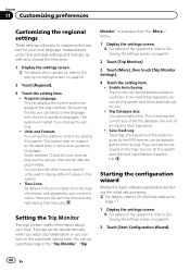
... as to choose the time zone. 1 Display the settings screen. = For details of available languages. You can set other country specific units used by the GPS receiver, can be saved manually when you reach your destination or you can access these logs later, you can record statistical data of the operations, refer...
... as to choose the time zone. 1 Display the settings screen. = For details of available languages. You can set other country specific units used by the GPS receiver, can be saved manually when you reach your destination or you can access these logs later, you can record statistical data of the operations, refer...

Owner's Manual
Page 66
... the double-sided tape. Place the GPS antenna on the surface as level as possible where the GPS antenna faces the window. Chapter 13 Installation Connecting the system Insert one end of the RGB cable into the "DATA BUS" slot on the side of your Pioneer AV receiver. Connect the other end of the... cable to the AV receiver using an 11 mm (.4 in ) screw...
... the double-sided tape. Place the GPS antenna on the surface as level as possible where the GPS antenna faces the window. Chapter 13 Installation Connecting the system Insert one end of the RGB cable into the "DATA BUS" slot on the side of your Pioneer AV receiver. Connect the other end of the... cable to the AV receiver using an 11 mm (.4 in ) screw...
Owner's Manual
Page 68
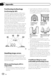
...which orbit at least three can also degrade the signals, so keep the antenna clear. GPS positioning is good, GPS can be lost temporarily. ! In this may not be received from more than two GPS satellites. ! When the signals are kept to cause noticeable positioning errors For various reasons... elevated roads or similar structures When driving among high buildings When driving through a dense forest or tall trees ! p If a GPS signal has not been received for a long time, your vehicle's actual position and the current position mark on the map may diverge considerably or may block...
...which orbit at least three can also degrade the signals, so keep the antenna clear. GPS positioning is good, GPS can be lost temporarily. ! In this may not be received from more than two GPS satellites. ! When the signals are kept to cause noticeable positioning errors For various reasons... elevated roads or similar structures When driving among high buildings When driving through a dense forest or tall trees ! p If a GPS signal has not been received for a long time, your vehicle's actual position and the current position mark on the map may diverge considerably or may block...
Owner's Manual
Page 74
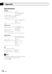
... frequency Approx. once per second GPS antenna Antenna Micro strip flat antenna/ right-handed helical polarization Antenna cable 3.0 m (9.84 ft.) Dimensions (W × H × D) ... 50.6 mm × 15.5 mm × 50.6 mm (1.99 in. × 0.61 in. × 1.99 in .) Weight 140 g (0.31 lbs) GPS receiver System L1, C/Acode GPS Reception system 32 tracking/32...
... frequency Approx. once per second GPS antenna Antenna Micro strip flat antenna/ right-handed helical polarization Antenna cable 3.0 m (9.84 ft.) Dimensions (W × H × D) ... 50.6 mm × 15.5 mm × 50.6 mm (1.99 in. × 0.61 in. × 1.99 in .) Weight 140 g (0.31 lbs) GPS receiver System L1, C/Acode GPS Reception system 32 tracking/32...


