Owner's Manual
Page 9
...the default settings 194 - Phone menu 221 - Theme menu 222 - Entering the password 193 - Deleting the password 193 - When positioning by GPS 203 - Video Setup menu 223 - Contents Other functions Selecting the video for playing a disc 208 Playable discs 208 - AVCHD recorded discs 209... - iPod and iPhone 218 - Dolby Digital 209 Detailed information for playable media 209 - iOS 218 - How do GPS and dead reckoning work together? 203 Handling large errors 204 - Positioning by dead reckoning 203 - Built-in drive and care 208 -...
...the default settings 194 - Phone menu 221 - Theme menu 222 - Entering the password 193 - Deleting the password 193 - When positioning by GPS 203 - Video Setup menu 223 - Contents Other functions Selecting the video for playing a disc 208 Playable discs 208 - AVCHD recorded discs 209... - iPod and iPhone 218 - Dolby Digital 209 Detailed information for playable media 209 - iOS 218 - How do GPS and dead reckoning work together? 203 Handling large errors 204 - Positioning by dead reckoning 203 - Built-in drive and care 208 -...
Owner's Manual
Page 24
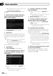
... require a subscription. p You will need to install the AVICSYNC App on page 47. The initial setup is now complete. The software collects usage information and GPS logs that the connected online features are activated appears if you want to Customizing the navigation settings on page 47. 10 Touch [Activate], then [Next...
... require a subscription. p You will need to install the AVICSYNC App on page 47. The initial setup is now complete. The software collects usage information and GPS logs that the connected online features are activated appears if you want to Customizing the navigation settings on page 47. 10 Touch [Activate], then [Next...

Owner's Manual
Page 27
... the route is set : p You can change the value by touching and holding any of the fields. Leave ferry. Approaching the destination. When GPS position is available, the arrow mark is transparent. When the route is not set : Distance to final destination, time needed to reach the final ...and surrounding map area. Browsing the data field The data fields are different when you are navigating the current route and when you have no GPS position, the arrow mark is displayed in full color, now showing your last known position. En 27 Approaching a waypoint. It shows your ...
... the route is set : p You can change the value by touching and holding any of the fields. Leave ferry. Approaching the destination. When GPS position is available, the arrow mark is transparent. When the route is not set : Distance to final destination, time needed to reach the final ...and surrounding map area. Browsing the data field The data fields are different when you are navigating the current route and when you have no GPS position, the arrow mark is displayed in full color, now showing your last known position. En 27 Approaching a waypoint. It shows your ...
Owner's Manual
Page 32
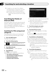
... or restaurants, is not set, they are searched around the last known position. 5 Touch the category you want . The route is not available either (no GPS signal), they are searched around the current position. Chapter 05 Searching for and selecting a location p If needed, you can select from different route alternatives or...
... or restaurants, is not set, they are searched around the last known position. 5 Touch the category you want . The route is not available either (no GPS signal), they are searched around the current position. Chapter 05 Searching for and selecting a location p If needed, you can select from different route alternatives or...
Owner's Manual
Page 39
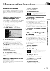
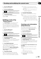
... routes, simulate them or see the details of the route alternatives and touch [Select]. The "Route Planner" screen appears. 4 Touch [Current GPS Position]. Setting a new starting point of route alternatives. The pop-up menu appears. 5 Touch [Set Start Point]. Touch any of them ... you can select another route and compare different route alternatives. Checking route alternatives for an existing route You can turn off the GPS receiver. Checking and modifying the current route Chapter 06 Checking and modifying the current route Modifying the route When navigation is already...
... routes, simulate them or see the details of the route alternatives and touch [Select]. The "Route Planner" screen appears. 4 Touch [Current GPS Position]. Setting a new starting point of route alternatives. The pop-up menu appears. 5 Touch [Set Start Point]. Touch any of them ... you can select another route and compare different route alternatives. Checking route alternatives for an existing route You can turn off the GPS receiver. Checking and modifying the current route Chapter 06 Checking and modifying the current route Modifying the route When navigation is already...
Owner's Manual
Page 40
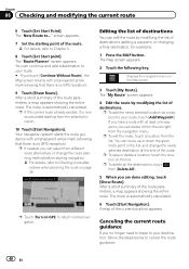
..." screen appears. Editing the list of destinations You can edit the route by modifying the list of the route. The route is no GPS reception). p If needed, you no GPS reception). 9 Touch [Show Route]. p To delete all the destinations, touch , then [Delete All]. 5 When you have a route with a ...To add the newly selected location as a waypoint to your destination, follow the steps below to Checking route alternatives when planning the route on GPS] to return normal navigation. You can move up or down the given route point in the list, and change the route planning method before...
..." screen appears. Editing the list of destinations You can edit the route by modifying the list of the route. The route is no GPS reception). p If needed, you no GPS reception). 9 Touch [Show Route]. p To delete all the destinations, touch , then [Delete All]. 5 When you have a route with a ...To add the newly selected location as a waypoint to your destination, follow the steps below to Checking route alternatives when planning the route on GPS] to return normal navigation. You can move up or down the given route point in the list, and change the route planning method before...
Owner's Manual
Page 41
... button. The total time of the route parameters, a map appears showing the entire route. The name and/or address of the route, normally the current GPS position. 4 Touch [Add Destination]. The following pieces of the route. = For details, refer to Checking route alternatives when planning the route on the Map screen...
... button. The total time of the route parameters, a map appears showing the entire route. The name and/or address of the route, normally the current GPS position. 4 Touch [Add Destination]. The following pieces of the route. = For details, refer to Checking route alternatives when planning the route on the Map screen...
Owner's Manual
Page 46
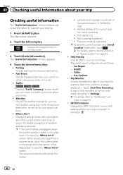
...Parking: Checks parking lots near your current location, along your route, around your destination, as well as follows. - Traffic: 8000NEX 7000NEX 6000NEX Displays "Traffic Summary" screen where you are as for nearby emergency or roadside assistance services. p If the current street... available) ! Car Repair: - Touch [Start New Recording] to start time, end time, average speed, etc.). GPS Information: Displays the GPS information screen with information about your trip Checking useful information The "Useful Information" menu contains various information to support your destination....
...Parking: Checks parking lots near your current location, along your route, around your destination, as well as follows. - Traffic: 8000NEX 7000NEX 6000NEX Displays "Traffic Summary" screen where you are as for nearby emergency or roadside assistance services. p If the current street... available) ! Car Repair: - Touch [Start New Recording] to start time, end time, average speed, etc.). GPS Information: Displays the GPS information screen with information about your trip Checking useful information The "Useful Information" menu contains various information to support your destination....
Owner's Manual
Page 47
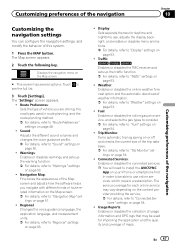
... to "Trip Monitor" set- Warnings: Enables or disables warnings and sets up the traffic function. = For details, refer to "Traffic" settings on page 53. ! Traffic: 8000NEX 7000NEX 6000NEX Enables or disables the TMC receiver and sets up the warning function. = For details, refer to "Warnings" settings on page 50. ! Trip Monitor...: Enables or disables the online weather forecast option and the automatic download of maps. Usage Reports: Enables or disables the collection of usage information and GPS logs that may vary depending on page 53. ! En 47
... to "Trip Monitor" set- Warnings: Enables or disables warnings and sets up the traffic function. = For details, refer to "Traffic" settings on page 53. ! Traffic: 8000NEX 7000NEX 6000NEX Enables or disables the TMC receiver and sets up the warning function. = For details, refer to "Warnings" settings on page 50. ! Trip Monitor...: Enables or disables the online weather forecast option and the automatic download of maps. Usage Reports: Enables or disables the collection of usage information and GPS logs that may vary depending on page 53. ! En 47
Owner's Manual
Page 54
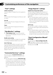
... "Start Configuration Wizard" settings You can decide whether you want to save track logs, the sequence of the positions given by the GPS receiver. First You can enable or disable the collection of anonymous statistical information on your trips. "Usage Reports" settings Application Usage Information... You can select the first gas price that you want to check. GPS Tracks You can later be able to enable or disable collecting anonymous track logs for later development purposes. p You will need to...
... "Start Configuration Wizard" settings You can decide whether you want to save track logs, the sequence of the positions given by the GPS receiver. First You can enable or disable the collection of anonymous statistical information on your trips. "Usage Reports" settings Application Usage Information... You can select the first gas price that you want to check. GPS Tracks You can later be able to enable or disable collecting anonymous track logs for later development purposes. p You will need to...
Owner's Manual
Page 160
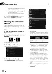
...After changing the installation angle of satellites whose signal has been received (yellow). The following keys in positioning Yes No p When the GPS antenna is connected to this product, "OK" is displayed. Chapter 31 System settings ! If signals from how many satellites the ...signal is poor, please change the installation position of the GPS antenna. 2 Positioning Status Displays the positioning status (3D positioning, 2D positioning, or no positioning), the number of satellites used for ...
...After changing the installation angle of satellites whose signal has been received (yellow). The following keys in positioning Yes No p When the GPS antenna is connected to this product, "OK" is displayed. Chapter 31 System settings ! If signals from how many satellites the ...signal is poor, please change the installation position of the GPS antenna. 2 Positioning Status Displays the positioning status (3D positioning, 2D positioning, or no positioning), the number of satellites used for ...
Owner's Manual
Page 203
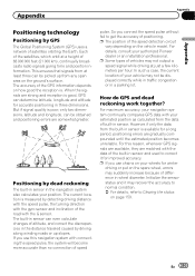
...altitude for improved accuracy. When the signals are gradually compounded until the estimated position becomes unreliable. But if signal quality is good, GPS can be picked up slopes. The current location is . For details, consult your vehicle may not output a speed signal while ...The built-in wheel diameter. If you use this reason, whenever GPS signals are available, they are somewhat greater. For this navigation system with the gyro sensor and inclination of your authorized Pioneer dealer or an installation professional. Initialize the sensor status and it...
...altitude for improved accuracy. When the signals are gradually compounded until the estimated position becomes unreliable. But if signal quality is good, GPS can be picked up slopes. The current location is . For details, consult your vehicle may not output a speed signal while ...The built-in wheel diameter. If you use this reason, whenever GPS signals are available, they are somewhat greater. For this navigation system with the gyro sensor and inclination of your authorized Pioneer dealer or an installation professional. Initialize the sensor status and it...

Owner's Manual
Page 204
... However, in a location on roads, and can also degrade the signals, so keep the antenna clear. Snow buildup can correct your position by combining GPS, dead reckoning and map matching. In this case, it to a minimum by adjusting it is called map matching. This is impossible for a long ...a car phone or cellular phone is restored, accuracy will be recovered. 204 En In such case, once GPS reception is used by GPS is disabled if signals cannot be received from GPS satellites may not reach your vehicle's actual position and the current position mark on occasion, place you in ...
... However, in a location on roads, and can also degrade the signals, so keep the antenna clear. Snow buildup can correct your position by combining GPS, dead reckoning and map matching. In this case, it to a minimum by adjusting it is called map matching. This is impossible for a long ...a car phone or cellular phone is restored, accuracy will be recovered. 204 En In such case, once GPS reception is used by GPS is disabled if signals cannot be received from GPS satellites may not reach your vehicle's actual position and the current position mark on occasion, place you in ...

Owner's Manual
Page 205
... you are driving on the map. ! If there is a loop or similar road configuration. ! If you are traveling on and the reception status of the GPS signal, the actual position of your vehicle may differ from the position displayed on the map screen. !
... you are driving on the map. ! If there is a loop or similar road configuration. ! If you are traveling on and the reception status of the GPS signal, the actual position of your vehicle may differ from the position displayed on the map screen. !

Owner's Manual
Page 206
... a gravel road or in a traffic congestion. ! When starting the engine. 206 En If your tires for a considerable period. ! If trees or other obstacles block the GPS signals for ones with many height changes. ! If you join the road after starting driving immediately after driving around a traffic circle. ! If your vehicle's wheels...
... a gravel road or in a traffic congestion. ! When starting the engine. 206 En If your tires for a considerable period. ! If trees or other obstacles block the GPS signals for ones with many height changes. ! If you join the road after starting driving immediately after driving around a traffic circle. ! If your vehicle's wheels...
Owner's Manual
Page 225
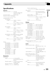
... × 36 mm (1-1/4 in. × 1/2 in. × 1-3/8 in .) Weight: AVIC-8000NEX 2.1 kg (4.6 lbs) AVIC-7000NEX 2.1 kg (4.6 lbs) AVIC-6000NEX 1.8 kg (4.0 lbs) AVIC-5000NEX 1.8 kg (4.0 lbs) AVIC-X8610BS 1.8 kg (4.0 lbs) NAND flash memory: AVIC-8000NEX 16 GB AVIC-7000NEX 8 GB AVIC-6000NEX 8 GB AVIC-5000NEX 8 GB AVIC-X8610BS 8 GB Navigation GPS receiver: System L1, C/Acode GPS SPS (Standard Positioning Service) Reception system .......... 12-channel multi...
... × 36 mm (1-1/4 in. × 1/2 in. × 1-3/8 in .) Weight: AVIC-8000NEX 2.1 kg (4.6 lbs) AVIC-7000NEX 2.1 kg (4.6 lbs) AVIC-6000NEX 1.8 kg (4.0 lbs) AVIC-5000NEX 1.8 kg (4.0 lbs) AVIC-X8610BS 1.8 kg (4.0 lbs) NAND flash memory: AVIC-8000NEX 16 GB AVIC-7000NEX 8 GB AVIC-6000NEX 8 GB AVIC-5000NEX 8 GB AVIC-X8610BS 8 GB Navigation GPS receiver: System L1, C/Acode GPS SPS (Standard Positioning Service) Reception system .......... 12-channel multi...
Installation Manual
Page 2
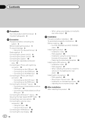
... on the steering column 30 - Parts supplied 29 - Connecting an Android device with 30-pin connector 15 - For AVIC-8000NEX and AVIC-7000NEX users 24 Installing this product 25 - Fastening the detachable faceplate 26 Installing the GPS antenna 27 - Parts supplied 27 - Connecting via the AUX input 15 - Connecting via the HDMI port 14...
... on the steering column 30 - Parts supplied 29 - Connecting an Android device with 30-pin connector 15 - For AVIC-8000NEX and AVIC-7000NEX users 24 Installing this product 25 - Fastening the detachable faceplate 26 Installing the GPS antenna 27 - Parts supplied 27 - Connecting via the AUX input 15 - Connecting via the HDMI port 14...
Installation Manual
Page 5
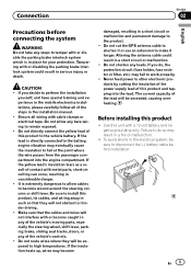
... WARNING Do not take any steps to tamper with or disable the parking brake interlock system which is in considerable danger. ! Do not cut the GPS antenna cable to shorten it or use an extension to high temperatures. If you decide to install this product, its cables, and wiring away in...
... WARNING Do not take any steps to tamper with or disable the parking brake interlock system which is in considerable danger. ! Do not cut the GPS antenna cable to shorten it or use an extension to high temperatures. If you decide to install this product, its cables, and wiring away in...
Installation Manual
Page 7
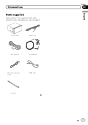
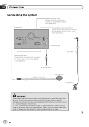
This product Power cord GPS antenna Microphone Mini-jack extension cable USB cable Lock tie* Section 02 En 7 English Connection Parts supplied Parts marked (*) are supplied with AVIC8000NEX, AVIC-7000NEX and AVIC-6000NEX.
This product Power cord GPS antenna Microphone Mini-jack extension cable USB cable Lock tie* Section 02 En 7 English Connection Parts supplied Parts marked (*) are supplied with AVIC8000NEX, AVIC-7000NEX and AVIC-6000NEX.
Installation Manual
Page 12
... some countries, the viewing of applicable laws, this product's video source should never be used . 12 En And, also rear displays should not be in .) GPS antenna Microphone WARNING · To avoid the risk of accident and the potential violation of images on a display inside a vehicle even by persons other than...
... some countries, the viewing of applicable laws, this product's video source should never be used . 12 En And, also rear displays should not be in .) GPS antenna Microphone WARNING · To avoid the risk of accident and the potential violation of images on a display inside a vehicle even by persons other than...


