
Triton User Manual Addendum - English, French, Spanish
Page 1
...Press ESC when you are done. On the contextual menu, select "Start New Track". Triton User Manual Addendum This addendum applies to Triton GPS receivers that have a software version that you can now access the Main Menu on any of assigning a name to the saved track ("Trail...many more options then were previously available. Scroll down the contextual menu and select "View Area Calculation". Pressing ENTER on any of the Navigational screens brings up the contextual menu with options to it's current location, point B. Pause and Resume Active Track. User Grid. (Advanced ...
...Press ESC when you are done. On the contextual menu, select "Start New Track". Triton User Manual Addendum This addendum applies to Triton GPS receivers that have a software version that you can now access the Main Menu on any of assigning a name to the saved track ("Trail...many more options then were previously available. Scroll down the contextual menu and select "View Area Calculation". Pressing ENTER on any of the Navigational screens brings up the contextual menu with options to it's current location, point B. Pause and Resume Active Track. User Grid. (Advanced ...

Triton User Manual Addendum - English, French, Spanish
Page 2
... screen, press ENTER and select "Disable Custom Position". When setting a custom position, the GPS portion of the entire route. To turn the feature off and resume computing GPS position information, go to bring up the contextual menu. The Navigation screen will be displayed with four legs, A to B to C to D to set...for your mind, you can direct it automatically begins routing you are already close to waypoint D and wish to go there instead of the receiver is disabled and the screen is set to the location you can tell the Triton to go to the next destination (C) and repeat the ...
... screen, press ENTER and select "Disable Custom Position". When setting a custom position, the GPS portion of the entire route. To turn the feature off and resume computing GPS position information, go to bring up the contextual menu. The Navigation screen will be displayed with four legs, A to B to C to D to set...for your mind, you can direct it automatically begins routing you are already close to waypoint D and wish to go there instead of the receiver is disabled and the screen is set to the location you can tell the Triton to go to the next destination (C) and repeat the ...
Manual - English
Page 2
...; IMPORTANT SAFETY WARNINGS The Magellan Triton is solely responsible for the accuracy and maintenance of the GPS network. Government, which you or others : IN THE INTERESTS OF SAFETY, DO NOT USE THIS NAVIGATION DEVICE WHILE DRIVING A VEHICLE. No part of this guide may severely degrade performance or damage the receiver, and will void the...
...; IMPORTANT SAFETY WARNINGS The Magellan Triton is solely responsible for the accuracy and maintenance of the GPS network. Government, which you or others : IN THE INTERESTS OF SAFETY, DO NOT USE THIS NAVIGATION DEVICE WHILE DRIVING A VEHICLE. No part of this guide may severely degrade performance or damage the receiver, and will void the...
Manual - English
Page 24
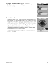
... displayed at the bottom of the display. The numbers indicate the GPS satellite ID while "W" indicates WAAS (Wide Area Augmentation System) satellites. Navigation Screens 16 The Altimeter / Barometer Screen (Magellan Triton 500) The Altimeter / Barometer screen displays your location. Green satellite icons represent satellites that is being used to compute your position while...
... displayed at the bottom of the display. The numbers indicate the GPS satellite ID while "W" indicates WAAS (Wide Area Augmentation System) satellites. Navigation Screens 16 The Altimeter / Barometer Screen (Magellan Triton 500) The Altimeter / Barometer screen displays your location. Green satellite icons represent satellites that is being used to compute your position while...
Manual - English
Page 26
... Speed measures how fast the user is , the better the accuracy. If no Go To or Route is set , this will appear blank or dashes. Navigation Screens 18 Cross Track Error (XTE) Cross Track Error measures how far the user is off the direct course to a destination point, not how fast... the time of day the user should be a negative distance if the user moves away from trees, tunnels, tall buildings, canyons, broadcast satellites, and other GPS receivers too close in distance) the progress the user has made .
... Speed measures how fast the user is , the better the accuracy. If no Go To or Route is set , this will appear blank or dashes. Navigation Screens 18 Cross Track Error (XTE) Cross Track Error measures how far the user is off the direct course to a destination point, not how fast... the time of day the user should be a negative distance if the user moves away from trees, tunnels, tall buildings, canyons, broadcast satellites, and other GPS receivers too close in distance) the progress the user has made .


