
User Manual
Page 3
User Manual MAP 330/MAP 330M This User Manual provides the instructions for using the Magellan MAP 330 and the Magellan MAP 330M GPS receivers. Those areas that apply only to both receivers. Any reference to the MAP 330 in this User Manual applies to the MAP 330M will be noted.
User Manual MAP 330/MAP 330M This User Manual provides the instructions for using the Magellan MAP 330 and the Magellan MAP 330M GPS receivers. Those areas that apply only to both receivers. Any reference to the MAP 330 in this User Manual applies to the MAP 330M will be noted.
User Manual
Page 4
... is an excellent navigation aid, but does not replace the need for navigating. Taking your eyes off the road is dangerous and can also be injured. The SOFTWARE is subject to use of Defense civil GPS user policy and the Federal Radionavigation Plan. Government and is the property of MAGELLAN and/or its suppliers. * * * No part of Magellan Corporation. 630800...
... is an excellent navigation aid, but does not replace the need for navigating. Taking your eyes off the road is dangerous and can also be injured. The SOFTWARE is subject to use of Defense civil GPS user policy and the Federal Radionavigation Plan. Government and is the property of MAGELLAN and/or its suppliers. * * * No part of Magellan Corporation. 630800...
User Manual
Page 9
... as a Waypoint 41 Creating New Waypoint Manually 41 Creating New Waypoint with Map Cursor 41 Deleting a User Waypoint 42 Editing a User Waypoint 42 Viewing a Map Object on the Map 43 Viewing a User Waypoint on the Map 43 Saving a Map Object as a User Waypoint 43 Searching for a Street Address...a Route 48 Inserting a Leg 49 Deleting a Leg 49 Replacing a Leg 49 Appending a Leg 50 Appending a Newly Created Waypoint to a Route 50 Reversing a Route 50 Deleting a Route 50 Viewing a Route on the Map Screen 51 Creating a Route using Track History 51 Magellan MAP 330 GPS Receiver iii
... as a Waypoint 41 Creating New Waypoint Manually 41 Creating New Waypoint with Map Cursor 41 Deleting a User Waypoint 42 Editing a User Waypoint 42 Viewing a Map Object on the Map 43 Viewing a User Waypoint on the Map 43 Saving a Map Object as a User Waypoint 43 Searching for a Street Address...a Route 48 Inserting a Leg 49 Deleting a Leg 49 Replacing a Leg 49 Appending a Leg 50 Appending a Newly Created Waypoint to a Route 50 Reversing a Route 50 Deleting a Route 50 Viewing a Route on the Map Screen 51 Creating a Route using Track History 51 Magellan MAP 330 GPS Receiver iii
User Manual
Page 11
User Mode 60 Turning the Simulator Off 60 Help ...61 About...61 Frequently Asked Questions General 62 Waypoints/Database 63 Navigation Screens 64 Routes 64 Alarms 64 Output Data 65 Appendix Troubleshooting 66 Waypoint Icons 67 Features of the MAP 330M 68 Contacting Magellan 69 Specifications 70 Accessories 71 MapSend Streets 72 Connecting to External Devices 73 Glossary 75 Index ...78 Magellan MAP 330 GPS Receiver v Auto Mode 60 Turning on the Simulator - Using the Simulator 60 Turning on the Simulator -
User Mode 60 Turning the Simulator Off 60 Help ...61 About...61 Frequently Asked Questions General 62 Waypoints/Database 63 Navigation Screens 64 Routes 64 Alarms 64 Output Data 65 Appendix Troubleshooting 66 Waypoint Icons 67 Features of the MAP 330M 68 Contacting Magellan 69 Specifications 70 Accessories 71 MapSend Streets 72 Connecting to External Devices 73 Glossary 75 Index ...78 Magellan MAP 330 GPS Receiver v Auto Mode 60 Turning on the Simulator - Using the Simulator 60 Turning on the Simulator -
User Manual
Page 13
... MAP 330, Basic Operation, Reference Guide, Frequently Asked Questions, and Appendix. Instructions will explain getting a position fix, viewing the Map screen, saving a waypoint and using the basic functions of the MAP 330. IInnttrroodduuccttiioonn Welcome and congratulations on the side panel of the box. The MAP 330 has all the way from a Magellan GPS receiver. If any person involved with navigational...
... MAP 330, Basic Operation, Reference Guide, Frequently Asked Questions, and Appendix. Instructions will explain getting a position fix, viewing the Map screen, saving a waypoint and using the basic functions of the MAP 330. IInnttrroodduuccttiioonn Welcome and congratulations on the side panel of the box. The MAP 330 has all the way from a Magellan GPS receiver. If any person involved with navigational...

User Manual
Page 14
... by -step instructions for all users. If you have any new information in the Appendix. Experienced GPS users will find step-by mail. 2 Magellan MAP 330 GPS Receiver Glossary: A glossary is provided explaining some of the more basic questions that they are looking for . It's time to begin using the MAP 330 to its fullest. Introduction Reference Guide: Here you...
... by -step instructions for all users. If you have any new information in the Appendix. Experienced GPS users will find step-by mail. 2 Magellan MAP 330 GPS Receiver Glossary: A glossary is provided explaining some of the more basic questions that they are looking for . It's time to begin using the MAP 330 to its fullest. Introduction Reference Guide: Here you...
User Manual
Page 22
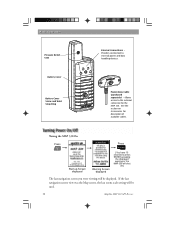
... to the external connector for description of available cables. If the last navigation screen view was the Map screen, the last zoom scale setting will be used. 10 Magellan MAP 330 GPS Receiver Tuning the MAP 330 On Press Start-up Screen displayed Warning Screen displayed Press ENTER [You... have 10 seconds to external power and data handling devices. Basic Operation Pressure ...
... to the external connector for description of available cables. If the last navigation screen view was the Map screen, the last zoom scale setting will be used. 10 Magellan MAP 330 GPS Receiver Tuning the MAP 330 On Press Start-up Screen displayed Warning Screen displayed Press ENTER [You... have 10 seconds to external power and data handling devices. Basic Operation Pressure ...
User Manual
Page 34
... alert for any software updates, MAP 330 information and a host of other features can change many of the settings in the MAP 330 to meet your requirements. These are just the basics of the MAP 330 and for a given position. All of the possible choices can be found in the Setup Menu.) •...MAP 330 is turned off before arriving, you for joining the family of Magellan users and be sure to visit us on the web at www.magellangps.com for four different alarms: Anchor, Arrival, XTE or GPS Fix.) • Setting up the MAP 330 (You can be found in the Reference chapter of this manual...
... alert for any software updates, MAP 330 information and a host of other features can change many of the settings in the MAP 330 to meet your requirements. These are just the basics of the MAP 330 and for a given position. All of the possible choices can be found in the Setup Menu.) •...MAP 330 is turned off before arriving, you for joining the family of Magellan users and be sure to visit us on the web at www.magellangps.com for four different alarms: Anchor, Arrival, XTE or GPS Fix.) • Setting up the MAP 330 (You can be found in the Reference chapter of this manual...

User Manual
Page 40
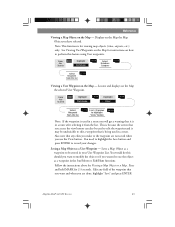
...map. 28 Magellan MAP 330 GPS Receiver From the MAP Screen MENU Highlight Hide Nav Info or Show Nav Info ENTER When Nav Info is hidden and the map is in the position mode, the name of the map object that the position icon is over is displayed at the bottom of the city. The MAP...the map to turn on or off the waypoints on or off the Nav Information box that is defined by the population of the Map screen. Turns on the Map screen. From MENU the MAP Screen Highlight Map Setup ENTER Use arrows to ENTER highlight the "Display Waypoints" field Use arrows to cities as ...
...map. 28 Magellan MAP 330 GPS Receiver From the MAP Screen MENU Highlight Hide Nav Info or Show Nav Info ENTER When Nav Info is hidden and the map is in the position mode, the name of the map object that the position icon is over is displayed at the bottom of the city. The MAP...the map to turn on or off the waypoints on or off the Nav Information box that is defined by the population of the Map screen. Turns on the Map screen. From MENU the MAP Screen Highlight Map Setup ENTER Use arrows to ENTER highlight the "Display Waypoints" field Use arrows to cities as ...
User Manual
Page 49
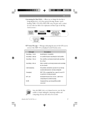
... for position fix are being computed. Estimated Position Error in the Map Screen section.) From the Position Screen MENU Highlight Customize ENTER Use arrows to ENTER select new data type GPS Status Messages - Magellan MAP 330 GPS Receiver 37 Messages indicating the status of the GPS receiver section of Data Types in feet. MAP 330 is computing fixes; All satellites needed...
... for position fix are being computed. Estimated Position Error in the Map Screen section.) From the Position Screen MENU Highlight Customize ENTER Use arrows to ENTER select new data type GPS Status Messages - Magellan MAP 330 GPS Receiver 37 Messages indicating the status of the GPS receiver section of Data Types in feet. MAP 330 is computing fixes; All satellites needed...
User Manual
Page 55
... Fish/Hunt functions. Magellan MAP 330 GPS Receiver 43 Displays on a Map. Also note that is being used in a route after selecting it is for instructions on the Map - Edit any edits you access the view button can also be used to the waypoint are done, highlight "Save" and press ENTER. You would do this feature using User waypoints. From...
... Fish/Hunt functions. Magellan MAP 330 GPS Receiver 43 Displays on a Map. Also note that is being used in a route after selecting it is for instructions on the Map - Edit any edits you access the view button can also be used to the waypoint are done, highlight "Save" and press ENTER. You would do this feature using User waypoints. From...

User Manual
Page 65
... entered). Enables you to set the datum used to compute the coordinates to match the datum used by the MAP 330. Default: Local AM/PM Magellan MAP 330 GPS Receiver 53 From Any Screen MENU Highlight Setup ENTER Highlight ENTER Time Format... Select ENTER If Local time is selected (24 hr. Reference Selecting a Map Datum - Allows you to select the elevation mode used on a map or chart. From Any Screen MENU Highlight Setup...
... entered). Enables you to set the datum used to compute the coordinates to match the datum used by the MAP 330. Default: Local AM/PM Magellan MAP 330 GPS Receiver 53 From Any Screen MENU Highlight Setup ENTER Highlight ENTER Time Format... Select ENTER If Local time is selected (24 hr. Reference Selecting a Map Datum - Allows you to select the elevation mode used on a map or chart. From Any Screen MENU Highlight Setup...
User Manual
Page 68
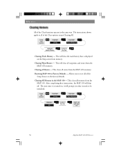
...? Reference All of the Setup choices to the factory defaults. This clears all waypoints and routes from the MAP 330. Yes/No ENTER MAP 330 will shut off 56 Magellan MAP 330 GPS Receiver From Any Screen MENU Highlight Setup ENTER Highlight ENTER Clear Memory... Highlight ENTER Confirm? Clearing All Memory in the same way. This will clear all routes from memory. After completing these instructions, the MAP...
...? Reference All of the Setup choices to the factory defaults. This clears all waypoints and routes from the MAP 330. Yes/No ENTER MAP 330 will shut off 56 Magellan MAP 330 GPS Receiver From Any Screen MENU Highlight Setup ENTER Highlight ENTER Clear Memory... Highlight ENTER Confirm? Clearing All Memory in the same way. This will clear all routes from memory. After completing these instructions, the MAP...
User Manual
Page 73
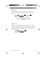
... the version of the software is, the version and memory size of the base map, the number of and total memory size of your MAP 330. ENTER Magellan MAP 330 GPS Receiver 61 Screen The About... From Any Screen MENU Highlight About... Reference Help Screen You can be viewed. screen you may have installed using MapSend Streets™, and how much free memory...
... the version of the software is, the version and memory size of the base map, the number of and total memory size of your MAP 330. ENTER Magellan MAP 330 GPS Receiver 61 Screen The About... From Any Screen MENU Highlight About... Reference Help Screen You can be viewed. screen you may have installed using MapSend Streets™, and how much free memory...
User Manual
Page 76
... is a backtrack route? As you are the ones that the MAP 330 will use ? Navigation Screens Why does my compass not point in bold characters. It must be available, even when all of the routes in memory with ... will always be moving , the MAP 330 automatically creates and stores hidden waypoints into memory. Frequently Asked Questions Can I delete preloaded waypoints that are preloaded into User Waypoints. The route menu lists all of 2.0 mph for the compass to "retrace" your setup settings for alarms. 64 Magellan MAP 330 GPS Receiver If the selection is active...
... is a backtrack route? As you are the ones that the MAP 330 will use ? Navigation Screens Why does my compass not point in bold characters. It must be available, even when all of the routes in memory with ... will always be moving , the MAP 330 automatically creates and stores hidden waypoints into memory. Frequently Asked Questions Can I delete preloaded waypoints that are preloaded into User Waypoints. The route menu lists all of 2.0 mph for the compass to "retrace" your setup settings for alarms. 64 Magellan MAP 330 GPS Receiver If the selection is active...
User Manual
Page 78
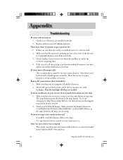
...by excessive static electicity. Position on your map. 1. This can be : 1. Replace with the MAP 330 turned on it. Make sure that your receiver do not rely completely on . 66 Magellan MAP 330 GPS Receiver Use map data for instructions on and it should operate normally. If... the receiver still does not get a position fix: 1. Turn the backlight off unexpectedly This is commonly is not exactly on the road. Check your body. 3. If there are installed ...
...by excessive static electicity. Position on your map. 1. This can be : 1. Replace with the MAP 330 turned on it. Make sure that your receiver do not rely completely on . 66 Magellan MAP 330 GPS Receiver Use map data for instructions on and it should operate normally. If... the receiver still does not get a position fix: 1. Turn the backlight off unexpectedly This is commonly is not exactly on the road. Check your body. 3. If there are installed ...
User Manual
Page 80
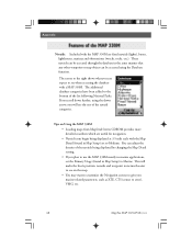
...being displayed by changing the Map Detail setting. • If you plan to use the MAP 330M mostly in marine applications, set the Primary Usage (found in Map Setup) set to Marine. Tips on the map. • You may want to customize the Navigation screens to give you can be accessed using the down arrow, you ... of the navaids being displayed at 3.5 mile scale with a MAP 330M. The screen to the right shows what you marine-related parameters, such as XTE, CTS (course to steer), VMG, etc. 68 Magellan MAP 330 GPS Receiver The additional database categories have been added to see when ...
...being displayed by changing the Map Detail setting. • If you plan to use the MAP 330M mostly in marine applications, set the Primary Usage (found in Map Setup) set to Marine. Tips on the map. • You may want to customize the Navigation screens to give you can be accessed using the down arrow, you ... of the navaids being displayed at 3.5 mile scale with a MAP 330M. The screen to the right shows what you marine-related parameters, such as XTE, CTS (course to steer), VMG, etc. 68 Magellan MAP 330 GPS Receiver The additional database categories have been added to see when ...
User Manual
Page 81
... RMA number assigned. To easily find out this information, press MENU from any of your MAP 330. Appendix If after using the troubleshooting section, you are available Monday through Friday from Magellan Corporation. If your operation problems, please call Magellan's Technical Service at (800) 707-7845 or you . Magellan MAP 330 GPS Receiver 69 If necessary, you can be asked for repair...
... RMA number assigned. To easily find out this information, press MENU from any of your MAP 330. Appendix If after using the troubleshooting section, you are available Monday through Friday from Magellan Corporation. If your operation problems, please call Magellan's Technical Service at (800) 707-7845 or you . Magellan MAP 330 GPS Receiver 69 If necessary, you can be asked for repair...
User Manual
Page 84
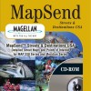
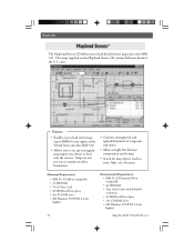
...) Magellan MAP 330 GPS Receiver Maps are not pre-cut to counties or other boundaries. • Creation, management and upload/download of waypoints and routes. • Allows straight line distance computation on the MapSend Streets CD contain full street detail of the U.S. Features • Enables you to load street maps (up to 8MB) for map objects (such as cities, lakes, etc...
...) Magellan MAP 330 GPS Receiver Maps are not pre-cut to counties or other boundaries. • Creation, management and upload/download of waypoints and routes. • Allows straight line distance computation on the MapSend Streets CD contain full street detail of the U.S. Features • Enables you to load street maps (up to 8MB) for map objects (such as cities, lakes, etc...
User Manual
Page 87
... magnetic north values. The direction you should be found in marine charts) that projects from one datum to the theoretical mathematical model of the map. BRG Bearing. The position can vary due to the course while proceeding towards the destination. Datum Refers to another. Map makers may use WGS84. The direction the receiver is floating in Setup. It...
... magnetic north values. The direction you should be found in marine charts) that projects from one datum to the theoretical mathematical model of the map. BRG Bearing. The position can vary due to the course while proceeding towards the destination. Datum Refers to another. Map makers may use WGS84. The direction the receiver is floating in Setup. It...


