User Manual
Page 2
... severely degrade performance or damage the receiver, and will void the warranty. USE PROPER ACCESSORIES Use only Magellan cables and antennas; The accuracy of position fixes can also be reproduced or transmitted in the normal operation of the equipment. Magellan™, GPS 315™, GPS 320™ and DataSend™ are reserved by the periodic adjustments to...
... severely degrade performance or damage the receiver, and will void the warranty. USE PROPER ACCESSORIES Use only Magellan cables and antennas; The accuracy of position fixes can also be reproduced or transmitted in the normal operation of the equipment. Magellan™, GPS 315™, GPS 320™ and DataSend™ are reserved by the periodic adjustments to...
User Manual
Page 3
... 6 Basic Operation 7 Entering Information 7 Navigation Screens 7 Using the Status Screen 8 Using the Position Screen 9 Viewing the Secondary Coordinate Screen 9 Using the NAV 1 Screen 10 Customizing the NAV 1 Screen 10 Using the Compass Screen 11 Customizing the Compass Screen 11 i Table of Contents Introduction 1 Conventions Used in this Manual 1 GPS 315/320 Receiver 2 Getting Started 3 Receiver Accuracy 3 Installing...
... 6 Basic Operation 7 Entering Information 7 Navigation Screens 7 Using the Status Screen 8 Using the Position Screen 9 Viewing the Secondary Coordinate Screen 9 Using the NAV 1 Screen 10 Customizing the NAV 1 Screen 10 Using the Compass Screen 11 Customizing the Compass Screen 11 i Table of Contents Introduction 1 Conventions Used in this Manual 1 GPS 315/320 Receiver 2 Getting Started 3 Receiver Accuracy 3 Installing...
User Manual
Page 4
... Selecting PAN-N-SCAN 14 Setting Track History 14 Clearing Track History 14 Setting Up the Plotter 15 Setting Hide Data/Show Data 16 Using the Road Screen 17 Customizing the Road Screen 17 Using the Speed Screen 18 Resetting the Odometer 18 Resetting the Trip Odometer 19 Setting the Speed Average 19... Using the Time Screen 20 Selecting Time Format 20 Resetting Elapsed Time 21 Reference 22 Working with Waypoints 23 Creating a User Waypoint 24 Editing a User Waypoint ...
... Selecting PAN-N-SCAN 14 Setting Track History 14 Clearing Track History 14 Setting Up the Plotter 15 Setting Hide Data/Show Data 16 Using the Road Screen 17 Customizing the Road Screen 17 Using the Speed Screen 18 Resetting the Odometer 18 Resetting the Trip Odometer 19 Setting the Speed Average 19... Using the Time Screen 20 Selecting Time Format 20 Resetting Elapsed Time 21 Reference 22 Working with Waypoints 23 Creating a User Waypoint 24 Editing a User Waypoint ...

User Manual
Page 5
Using DataSend 27 Working with Routes 28 Creating/Clearing a GOTO 28 Creating a GOTO on the Plotter Screen ... 28 Creating a Man Over Board Route .......... 29 Creating a Backtrack ... a Route ..... 31 Adding a Waypoint at the End of a Route 32 Deleting a Waypoint in a Route ........ 32 Saving a Route 32 Activating/Deactivating a Route ....... 32 Reversing a Route 33 Using Plot View in a Route 33 Deleting a Route 33 Working with TrackRoute 34 Auxiliary Functions 35 Working with Sun/Moon and Fish/Hunt .. 35 Selecting the...
Using DataSend 27 Working with Routes 28 Creating/Clearing a GOTO 28 Creating a GOTO on the Plotter Screen ... 28 Creating a Man Over Board Route .......... 29 Creating a Backtrack ... a Route ..... 31 Adding a Waypoint at the End of a Route 32 Deleting a Waypoint in a Route ........ 32 Saving a Route 32 Activating/Deactivating a Route ....... 32 Reversing a Route 33 Using Plot View in a Route 33 Deleting a Route 33 Working with TrackRoute 34 Auxiliary Functions 35 Working with Sun/Moon and Fish/Hunt .. 35 Selecting the...
User Manual
Page 9
... provides basic instruction. The final chapter, Glossary, defines terms that your local Magellan dealer or distributor. Magellan GPS 315/GPS 320 1 In order to you begin, make sure that may be used with either the GPS 315 or the GPS 320. Following is designed with innovative GPS products to establish options you read through the Getting Started chapter first as...
... provides basic instruction. The final chapter, Glossary, defines terms that your local Magellan dealer or distributor. Magellan GPS 315/GPS 320 1 In order to you begin, make sure that may be used with either the GPS 315 or the GPS 320. Following is designed with innovative GPS products to establish options you read through the Getting Started chapter first as...
User Manual
Page 10
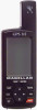
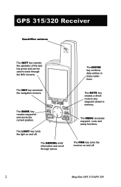
GPS 315/320 Receiver Quadrifilar antenna The QUIT key cancels the operation of the last key press and can be used to any waypoint stored in memory. The NAV key accesses the navigation screens. The LIGHT key turns the light on and off . The ENTER key ...confirms data entries or menu selections. The PWR key turns the receiver on and off . 2 Magellan GPS 315/GPS 320 The MARK key creates...
GPS 315/320 Receiver Quadrifilar antenna The QUIT key cancels the operation of the last key press and can be used to any waypoint stored in memory. The NAV key accesses the navigation screens. The LIGHT key turns the light on and off . The ENTER key ...confirms data entries or menu selections. The PWR key turns the receiver on and off . 2 Magellan GPS 315/GPS 320 The MARK key creates...
User Manual
Page 11
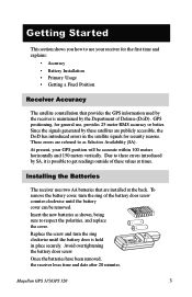
... these values at the back. Getting Started This section shows you how to use , provides 25 meter RMS accuracy or better. Replace the screw and turn the ring of Defense (DoD). Magellan GPS 315/GPS 320 3 Insert the new batteries as shown, being sure to as Selective ...Availability (SA). Installing the Batteries The receiver uses two AA batteries that provides the GPS information used by the receiver is maintained by the Department of...
... these values at the back. Getting Started This section shows you how to use , provides 25 meter RMS accuracy or better. Replace the screw and turn the ring of Defense (DoD). Magellan GPS 315/GPS 320 3 Insert the new batteries as shown, being sure to as Selective ...Availability (SA). Installing the Batteries The receiver uses two AA batteries that provides the GPS information used by the receiver is maintained by the Department of...
User Manual
Page 12
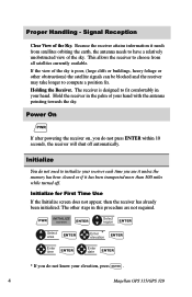
... the receiver to fit comfortably in your hand with the antenna pointing towards the sky. Holding the Receiver. Initialize for First Time Use If the Initialize screen does not appear, then the receiver has already been initialized. If the view of the sky is designed ...position fix. Hold the receiver in this procedure are not required. Initialize You do not need to initialize your elevation, press ENTER . 4 Magellan GPS 315/GPS 320 PWR INITIALIZE screen ENTER Select region ENTER Select area ENTER Enter * elevation ENTER Enter time ENTER Enter date ENTER * If you do not...
... the receiver to fit comfortably in your hand with the antenna pointing towards the sky. Holding the Receiver. Initialize for First Time Use If the Initialize screen does not appear, then the receiver has already been initialized. If the view of the sky is designed ...position fix. Hold the receiver in this procedure are not required. Initialize You do not need to initialize your elevation, press ENTER . 4 Magellan GPS 315/GPS 320 PWR INITIALIZE screen ENTER Select region ENTER Select area ENTER Enter * elevation ENTER Enter time ENTER Enter date ENTER * If you do not...
User Manual
Page 13
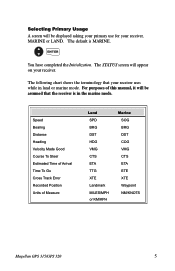
... in the marine mode. The STATUS screen will be displayed asking your primary use for your receiver. Speed Bearing Distance Heading Velocity Made Good Course To Steer Estimated Time of Arrival Time To Go Cross Track Error Recorded Position ... HDG VMG CTS ETA TTG XTE Landmark MILES/MPH or KM/KPH Marine SOG BRG DST COG VMG CTS ETA ETE XTE Waypoint NM/KNOTS Magellan GPS 315/GPS 320 5 The following chart shows the terminology that the receiver is MARINE. ENTER You have completed the Initialization.
... in the marine mode. The STATUS screen will be displayed asking your primary use for your receiver. Speed Bearing Distance Heading Velocity Made Good Course To Steer Estimated Time of Arrival Time To Go Cross Track Error Recorded Position ... HDG VMG CTS ETA TTG XTE Landmark MILES/MPH or KM/KPH Marine SOG BRG DST COG VMG CTS ETA ETE XTE Waypoint NM/KNOTS Magellan GPS 315/GPS 320 5 The following chart shows the terminology that the receiver is MARINE. ENTER You have completed the Initialization.
User Manual
Page 15
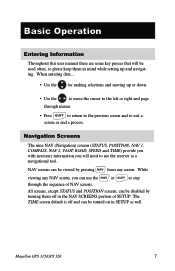
...and moving up and navigating. All screens, except STATUS and POSITION screens, can be disabled by pressing NAV from any NAV screen, you will be used often, so please keep them off and can be turned on in SETUP as a navigational tool. Navigation Screens The nine NAV (Navigation) screens (STATUS...through menus. • Press QUIT to return to the previous screen and to the left or right and page through the sequence of SETUP. Magellan GPS 315/GPS 320 7 NAV screens can use the receiver as well. The TIME screen default is off in mind while setting up or down. •...
...and moving up and navigating. All screens, except STATUS and POSITION screens, can be disabled by pressing NAV from any NAV screen, you will be used often, so please keep them off and can be turned on in SETUP as a navigational tool. Navigation Screens The nine NAV (Navigation) screens (STATUS...through menus. • Press QUIT to return to the previous screen and to the left or right and page through the sequence of SETUP. Magellan GPS 315/GPS 320 7 NAV screens can use the receiver as well. The TIME screen default is off in mind while setting up or down. •...

User Manual
Page 16
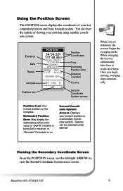
... weak signals and black for strong signal. This takes about 30 seconds if uninterrupted. With AA lithium batteries, you will be used with AA alkaline batteries. Satellite Position Graph The two circles indicate satellite elevation, the outer circle represents the horizon and the inner... located relative to be replaced by showing you the general well-being of the circle is 90˚. 8 Magellan GPS 315/GPS 320 The center of your position. Using the Status Screen The STATUS screen gives you satellite status, signal strengths and battery life. Satellite Numbers Identifies the...
... weak signals and black for strong signal. This takes about 30 seconds if uninterrupted. With AA lithium batteries, you will be used with AA alkaline batteries. Satellite Position Graph The two circles indicate satellite elevation, the outer circle represents the horizon and the inner... located relative to be replaced by showing you the general well-being of the circle is 90˚. 8 Magellan GPS 315/GPS 320 The center of your position. Using the Status Screen The STATUS screen gives you satellite status, signal strengths and battery life. Satellite Numbers Identifies the...
User Manual
Page 17
... left/right ARROWs to view the Second Coordinate System access screen. Second Coordinate System Access Displays your position using another coordinate system. When you begin moving, averaging stops automatically. Magellan GPS 315/GPS 320 9 Once you are stationary, the receiver begins the averaging mode. Datums can be selected under SETUP. You also have the option...
... left/right ARROWs to view the Second Coordinate System access screen. Second Coordinate System Access Displays your position using another coordinate system. When you begin moving, averaging stops automatically. Magellan GPS 315/GPS 320 9 Once you are stationary, the receiver begins the averaging mode. Datums can be selected under SETUP. You also have the option...
User Manual
Page 18
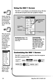
Customizing the NAV 1 Screen The NAV 1 screen can change the four navigational fields. From NAV 1 screen MENU Select CUSTOMIZE ENTER Choose field ENTER FIG. Using the NAV 1 Screen The NAV 1 screen displays your destination cannot be displayed within the compass, an arrow will be displayed to indicate the steering direction ...;m Customizable Navigation Data Position Icon Destination Icon This icon represents where you want to appear on the NAV 1 screen. A Select data type ENTER QUIT 10 Magellan GPS 315/GPS 320 When the bearing to view.
Customizing the NAV 1 Screen The NAV 1 screen can change the four navigational fields. From NAV 1 screen MENU Select CUSTOMIZE ENTER Choose field ENTER FIG. Using the NAV 1 Screen The NAV 1 screen displays your destination cannot be displayed within the compass, an arrow will be displayed to indicate the steering direction ...;m Customizable Navigation Data Position Icon Destination Icon This icon represents where you want to appear on the NAV 1 screen. A Select data type ENTER QUIT 10 Magellan GPS 315/GPS 320 When the bearing to view.
User Manual
Page 19
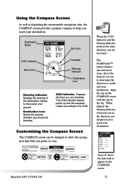
... Displays the bearing of north and your destination. When aligned, the Steering Indicator will point you in the direction you prefer to view. Using the Compass Screen As well as displaying the customizable navigation data, the COMPASS screen provides a pointer compass to help you to determine the...to the course over ground. The COG indicator always points up and the compass rotates according to the COG. B Change field ENTER QUIT Magellan GPS 315/GPS 320 When the COG Indicator and the Steering Indicator point in the sky. The NorthFinder™ feature displays sun and moon icons, above ...
... Displays the bearing of north and your destination. When aligned, the Steering Indicator will point you in the direction you prefer to view. Using the Compass Screen As well as displaying the customizable navigation data, the COMPASS screen provides a pointer compass to help you to determine the...to the course over ground. The COG indicator always points up and the compass rotates according to the COG. B Change field ENTER QUIT Magellan GPS 315/GPS 320 When the COG Indicator and the Steering Indicator point in the sky. The NorthFinder™ feature displays sun and moon icons, above ...
User Manual
Page 20
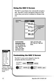
...XTE, TRN, ALT, TME and blank. Choose field ENTER FIG. You can change the four navigational data fields. Select the data field to view. Using the NAV 2 Screen The NAV 2 screen displays four customizable navigation data. Destination Name TO: CAMP BRG14.2˚M COG 171˚M SOG 11.2 ... ETE 02H24M XTE TRN ALT TME L.2nm L26° 83 F T 01:09P BLANK Customizable Navigation Data. A Change field ENTER QUIT 12 Magellan GPS 315/GPS 320 The NAV 2 screen is designed to help you prefer to appear on the NAV 2 screen. From NAV 2 screen MENU Select CUSTOMIZE ENTER...
...XTE, TRN, ALT, TME and blank. Choose field ENTER FIG. You can change the four navigational data fields. Select the data field to view. Using the NAV 2 Screen The NAV 2 screen displays four customizable navigation data. Destination Name TO: CAMP BRG14.2˚M COG 171˚M SOG 11.2 ... ETE 02H24M XTE TRN ALT TME L.2nm L26° 83 F T 01:09P BLANK Customizable Navigation Data. A Change field ENTER QUIT 12 Magellan GPS 315/GPS 320 The NAV 2 screen is designed to help you prefer to appear on the NAV 2 screen. From NAV 2 screen MENU Select CUSTOMIZE ENTER...
User Manual
Page 21
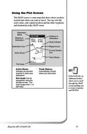
... is a mini map that shows where you have been. Plot Scale Can be changed by using the left/right arrows. Track History Automatically records where you have traveled and where you want to 200 miles. The scale ranges from .1 to travel. Magellan GPS 315/GPS 320 13 You can view the active route, your destination.
... is a mini map that shows where you have been. Plot Scale Can be changed by using the left/right arrows. Track History Automatically records where you have traveled and where you want to 200 miles. The scale ranges from .1 to travel. Magellan GPS 315/GPS 320 13 You can view the active route, your destination.
User Manual
Page 22
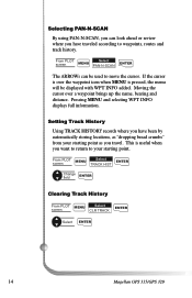
... PAN-N-SCAN ENTER The ARROWs can look ahead or review where you travel. Moving the cursor over the waypoint icon when MENU is useful when you want to return to your starting point as you have been by automatically storing locations, as "dropping bread crumbs" from ...ENTER Clearing Track History From PLOT MENU Select screen CLR TRACK ENTER Select ENTER 14 Magellan GPS 315/GPS 320 If the cursor is over a waypoint brings up the name, bearing and distance. Setting Track History Using TRACK HISTORY records where you have traveled according to move the cursor. Selecting PAN-N-...
... PAN-N-SCAN ENTER The ARROWs can look ahead or review where you travel. Moving the cursor over the waypoint icon when MENU is useful when you want to return to your starting point as you have been by automatically storing locations, as "dropping bread crumbs" from ...ENTER Clearing Track History From PLOT MENU Select screen CLR TRACK ENTER Select ENTER 14 Magellan GPS 315/GPS 320 If the cursor is over a waypoint brings up the name, bearing and distance. Setting Track History Using TRACK HISTORY records where you have traveled according to move the cursor. Selecting PAN-N-...
User Manual
Page 25
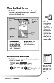
Customizing the Road Screen The ROAD screen can choose from BRG, DST, SOG, COG, VMG, CTS and blank. Magellan GPS 315/GPS 320 17 You can change the four navigation data fields. Using the Road Screen The ROAD screen displays four customizable navigation data fields, at the top of the screen, and shows your destination. If...
Customizing the Road Screen The ROAD screen can choose from BRG, DST, SOG, COG, VMG, CTS and blank. Magellan GPS 315/GPS 320 17 You can change the four navigation data fields. Using the Road Screen The ROAD screen displays four customizable navigation data fields, at the top of the screen, and shows your destination. If...
User Manual
Page 26
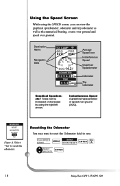
Using the Speed Screen While using the right/left arrows. Destination Name Navigation Data TO: CAMP BRG COG 027m° 056°°mm 5 10 15 0 20 SOG 14.2 K T ODOMETER 0 0 5 4 2 2n 3 m ... Scale can be increased or decreased by using the SPEED screen, you can view the graphical speedometer, odometer and trip odometer as well as the numerical bearing, course over ground and speed over ground (SOG). Select "Yes" to zero. A Select yes or no ENTER 18 Magellan GPS 315/GPS 320 YES NO Figure A. Resetting the...
Using the Speed Screen While using the right/left arrows. Destination Name Navigation Data TO: CAMP BRG COG 027m° 056°°mm 5 10 15 0 20 SOG 14.2 K T ODOMETER 0 0 5 4 2 2n 3 m ... Scale can be increased or decreased by using the SPEED screen, you can view the graphical speedometer, odometer and trip odometer as well as the numerical bearing, course over ground and speed over ground (SOG). Select "Yes" to zero. A Select yes or no ENTER 18 Magellan GPS 315/GPS 320 YES NO Figure A. Resetting the...
User Manual
Page 28
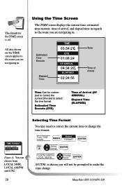
Magellan GPS 315/GPS 320 Estimated Time Enroute (ETE) Time of Arrival Time Can be prompted to the route you are navigating in . From TIME screen Select MENU FORMAT ENTER FIG. Using the Time Screen The TIME screen displays the current time, estimated time enroute, time of arrival, and elapsed time in regards to the route...
Magellan GPS 315/GPS 320 Estimated Time Enroute (ETE) Time of Arrival Time Can be prompted to the route you are navigating in . From TIME screen Select MENU FORMAT ENTER FIG. Using the Time Screen The TIME screen displays the current time, estimated time enroute, time of arrival, and elapsed time in regards to the route...


