
Owner's Manual
Page 21
...unit's internal memory. Press MENU twice > Tracks. 2 Select Save. eTrex HC series Owner's Manual 17 Using this option allows you to save the entire track log: 1. To save the entire track. 3. Data card option (HCx units only) • Wrap When Full-the track log records over ...the oldest data with new data. • Record Method-distance records track points after a specified time has elapsed. Press MENU twice > Tracks. 2. Basic Operation • Color-select the color of the microSD card)....
...unit's internal memory. Press MENU twice > Tracks. 2 Select Save. eTrex HC series Owner's Manual 17 Using this option allows you to save the entire track log: 1. To save the entire track. 3. Data card option (HCx units only) • Wrap When Full-the track log records over ...the oldest data with new data. • Record Method-distance records track points after a specified time has elapsed. Press MENU twice > Tracks. 2. Basic Operation • Color-select the color of the microSD card)....
Owner's Manual
Page 22
...the data can result. This file is recorded for the indicated date. Basic Operation Track distance Track color Track name Calculated area Saved Track Page To save only a portion of the track log. 4. ...Note: Do not remove the microSD card from the microSD card, highlight individual logs, and then press ENTER. eTrex HC series Owner's Manual Press MENU twice > Tracks. 2. A current date .gpx file appears in the Data ...data for each day you want to an HCx unit microSD card: 1. Open the track logs using Garmin MapSource or another .gpx file-compatible application. 4.
...the data can result. This file is recorded for the indicated date. Basic Operation Track distance Track color Track name Calculated area Saved Track Page To save only a portion of the track log. 4. ...Note: Do not remove the microSD card from the microSD card, highlight individual logs, and then press ENTER. eTrex HC series Owner's Manual Press MENU twice > Tracks. 2. A current date .gpx file appears in the Data ...data for each day you want to an HCx unit microSD card: 1. Open the track logs using Garmin MapSource or another .gpx file-compatible application. 4.
Owner's Manual
Page 28
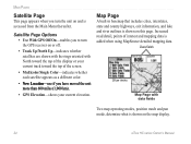
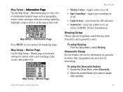
Satellite Page Options • Use With GPS Off/On-enables you to turn the unit on the map display. 24 eTrex HC series Owner's Manual Map Page A built-in basemap that includes cities, interstates, state and county highways, exit information, and lake and river ... shown on and is added when using MapSource detailed mapping data. Increased road detail, points of the screen. • Multicolor/Single Color-indicates whether each satellite appears as a different color. • New Location-use if you have moved the unit more than 600 miles (1,000 km). • GPS Elevation-shows ...
Satellite Page Options • Use With GPS Off/On-enables you to turn the unit on the map display. 24 eTrex HC series Owner's Manual Map Page A built-in basemap that includes cities, interstates, state and county highways, exit information, and lake and river ... shown on and is added when using MapSource detailed mapping data. Increased road detail, points of the screen. • Multicolor/Single Color-indicates whether each satellite appears as a different color. • New Location-use if you have moved the unit more than 600 miles (1,000 km). • GPS Elevation-shows ...
Owner's Manual
Page 41
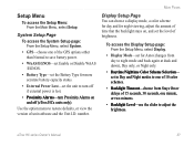
... Level-use the slider to restore defaults, or view the version of 10 color schemes. • Backlight Timeout-choose from day to turn off (eTrex HCx units only). Main Pages Display Setup Page You can choose a display mode, a color scheme for day and for Auto (changes from Stays On or delays of ...15 seconds, 30 seconds, one of unit software and the Unit I.D. eTrex HC series Owner's Manual 37 Setup...
... Level-use the slider to restore defaults, or view the version of 10 color schemes. • Backlight Timeout-choose from day to turn off (eTrex HCx units only). Main Pages Display Setup Page You can choose a display mode, a color scheme for day and for Auto (changes from Stays On or delays of ...15 seconds, 30 seconds, one of unit software and the Unit I.D. eTrex HC series Owner's Manual 37 Setup...
Owner's Manual
Page 45
...Vista HCx and Legend HCx only). Map Setup - To setup the Geocache feature: 1. Select the symbol fields if you want to view a list of downloaded detailed maps such as topographic, marine charts, and maps with auto-routing capability. Map Setup - Routing Setup Choose options for marine colors, spot soundings, light sectors, and symbol sets. eTrex... HC series Owner's Manual 41 Highlight a map to show it on or off . Information Page Press MENU to use (Auto, GARMIN, NOAA, International). Geocache Setup See the Garmin...
...Vista HCx and Legend HCx only). Map Setup - To setup the Geocache feature: 1. Select the symbol fields if you want to view a list of downloaded detailed maps such as topographic, marine charts, and maps with auto-routing capability. Map Setup - Routing Setup Choose options for marine colors, spot soundings, light sectors, and symbol sets. eTrex... HC series Owner's Manual 41 Highlight a map to show it on or off . Information Page Press MENU to use (Auto, GARMIN, NOAA, International). Geocache Setup See the Garmin...
Owner's Manual
Page 49
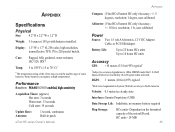
..., 12 V DC Adapter Cable, or PC/USB Adapter Battery Life: Up to 25 hours HCx units Up to 14 hours HC units Accuracy GPS: Display: 1.3" W x 1.7" H, 256-color, high resolution, transreflective TFT(176 x 220 pixels) backlit. Appendix Appendix Compass: (Vista HCx/Summit HC only) Accuracy; +/- 5 degrees, resolution; 1 degree, user calibrated Specifications Physical Size: 4.2" H x 2.2" W x 1.2" D Weight: 5.6 ounces...
..., 12 V DC Adapter Cable, or PC/USB Adapter Battery Life: Up to 25 hours HCx units Up to 14 hours HC units Accuracy GPS: Display: 1.3" W x 1.7" H, 256-color, high resolution, transreflective TFT(176 x 220 pixels) backlit. Appendix Appendix Compass: (Vista HCx/Summit HC only) Accuracy; +/- 5 degrees, resolution; 1 degree, user calibrated Specifications Physical Size: 4.2" H x 2.2" W x 1.2" D Weight: 5.6 ounces...
Quick Reference Guide
Page 1
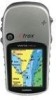
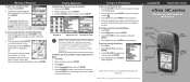
... HC, and Venture HC GPS antenna IN/OUT (Zoom) keys ENTER/ROCKER key MENU/FIND key QUIT/ PAGE key POWER/ Backlight key Color LCD display (eTrex Vista HCx shown) (eTrex Vista HCx shown) Marking a Waypoint To mark your changes, select OK, and press ENTER. To create a new waypoint using the Find Menu: ...on the Mark Waypoint page, select the appropriate field, and press ENTER to , and press ENTER. 4. message appears. B © Copyright 2007 Garmin Ltd. Select Yes, and press ENTER. Follow the magenta route created on -screen keypad. Use the ROCKER to the new map location. Select ...
... HC, and Venture HC GPS antenna IN/OUT (Zoom) keys ENTER/ROCKER key MENU/FIND key QUIT/ PAGE key POWER/ Backlight key Color LCD display (eTrex Vista HCx shown) (eTrex Vista HCx shown) Marking a Waypoint To mark your changes, select OK, and press ENTER. To create a new waypoint using the Find Menu: ...on the Mark Waypoint page, select the appropriate field, and press ENTER to , and press ENTER. 4. message appears. B © Copyright 2007 Garmin Ltd. Select Yes, and press ENTER. Follow the magenta route created on -screen keypad. Use the ROCKER to the new map location. Select ...


