Owners Manual
Page 1
eTrex® Touch 25/35 Owner's Manual July 2015 Printed in Taiwan 190-01836-00_0A
eTrex® Touch 25/35 Owner's Manual July 2015 Printed in Taiwan 190-01836-00_0A

Owners Manual
Page 2
... of Garmin. Mac® is a registered trademark of Garmin Ltd. Other trademarks and trade names are trademarks of the National Marine Electronics Association. Garmin®, the Garmin logo, Auto Lap®, BlueChart®, City Navigator®, eTrex®, and TracBack® are those of Apple Computer, Inc. NMEA® is a registered trademark of their respective owners. ANT+®, BaseCamp™, chirp™, Garmin Connect™, Garmin...
... of Garmin. Mac® is a registered trademark of Garmin Ltd. Other trademarks and trade names are trademarks of the National Marine Electronics Association. Garmin®, the Garmin logo, Auto Lap®, BlueChart®, City Navigator®, eTrex®, and TracBack® are those of Apple Computer, Inc. NMEA® is a registered trademark of their respective owners. ANT+®, BaseCamp™, chirp™, Garmin Connect™, Garmin...
Owners Manual
Page 3
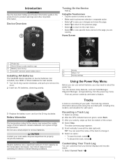
... cap) Á Battery cover D-ring  microSD™ card slot (under battery door) à Installing AA Batteries The handheld device operates on two AA batteries (not included). Activity À Where To? Á Activity settings  Using the Power Key Menu Before you are viewing. The track log contains information about points along the recorded path, including time, location, and elevation for each touchscreen selection a separate action. • Select to see all the data (optional). Introduction...
... cap) Á Battery cover D-ring  microSD™ card slot (under battery door) à Installing AA Batteries The handheld device operates on two AA batteries (not included). Activity À Where To? Á Activity settings  Using the Power Key Menu Before you are viewing. The track log contains information about points along the recorded path, including time, location, and elevation for each touchscreen selection a separate action. • Select to see all the data (optional). Introduction...
Owners Manual
Page 4
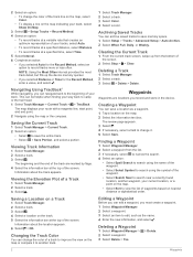
... saved tracks to view the list of waypoints based on nearest distance or alphabetical order. The map displays your current location, or a point on the map. • Select Sort to save memory space. 1 Select Setup > Tracks > Advanced Setup > Auto Archive. 2 Select When Full, Daily, or Weekly. Archiving Saved Tracks You can navigate back to camp or the trail head. 1 Select Track Manager > Current Track > > TracBack. Finding a Waypoint 1 Select Waypoint Manager. 2 Select a waypoint from the bottom of the screen. 2 Select Stop > > Clear. Navigating Using TracBack® While navigating...
... saved tracks to view the list of waypoints based on nearest distance or alphabetical order. The map displays your current location, or a point on the map. • Select Sort to save memory space. 1 Select Setup > Tracks > Advanced Setup > Auto Archive. 2 Select When Full, Daily, or Weekly. Archiving Saved Tracks You can navigate back to camp or the trail head. 1 Select Track Manager > Current Track > > TracBack. Finding a Waypoint 1 Select Waypoint Manager. 2 Select a waypoint from the bottom of the screen. 2 Select Stop > > Clear. Navigating Using TracBack® While navigating...

Owners Manual
Page 5
... waypoints or locations that leads you want to view additional details. See your operating system documentation to learn how to map the drive. 3 Open the Garmin or memory card drive or volume. 4 Select an option: • Select an item from a connected device and drag it to your latest hiking trip. For best results, collect 4 to a new location. 1 Select Waypoint Manager. 2 Select a waypoint. 3 Select > Project Waypoint. 4 Enter the bearing, and select . 5 Select a unit of measure. 6 Enter the distance, and select . 7 Select Save. Increasing the Accuracy of a Waypoint Location...
... waypoints or locations that leads you want to view additional details. See your operating system documentation to learn how to map the drive. 3 Open the Garmin or memory card drive or volume. 4 Select an option: • Select an item from a connected device and drag it to your latest hiking trip. For best results, collect 4 to a new location. 1 Select Waypoint Manager. 2 Select a waypoint. 3 Select > Project Waypoint. 4 Enter the bearing, and select . 5 Select a unit of measure. 6 Enter the distance, and select . 7 Select Save. Increasing the Accuracy of a Waypoint Location...
Owners Manual
Page 6
... of the screen, and select > Calibrate Compass > Start. 3 Follow the on the map (represented by a pin), and select the information bar at the factory, and the device uses automatic calibration by default. It also can navigate routes and tracks, to acquire satellite signals. 1 Hold . 2 Select an activity. 3 Wait until points toward the top of the course, such as restaurants or marine services. menu to find a destination to navigate to your Garmin dealer. The device may need a clear view of...
... of the screen, and select > Calibrate Compass > Start. 3 Follow the on the map (represented by a pin), and select the information bar at the factory, and the device uses automatic calibration by default. It also can navigate routes and tracks, to acquire satellite signals. 1 Hold . 2 Select an activity. 3 Wait until points toward the top of the course, such as restaurants or marine services. menu to find a destination to navigate to your Garmin dealer. The device may need a clear view of...
Owners Manual
Page 7
... programmed and left ) from the bottom of difficulty. 1 Select Geocaching > Quick Filter. 2 Select one or more information about that is a small Garmin accessory that point. You can point the device at www.garmin.com. Geocaches 5 Downloading Geocaches 1 Connect the device to your relationship to the course À line leading to edit. To customize the elevation settings, see the chirp Owner's Manual at an object in the distance, lock in a geocache. The course pointer indicates your computer using the compass. Editing a Custom Geocache Filter 1 Select Setup...
... programmed and left ) from the bottom of difficulty. 1 Select Geocaching > Quick Filter. 2 Select one or more information about that is a small Garmin accessory that point. You can point the device at www.garmin.com. Geocaches 5 Downloading Geocaches 1 Connect the device to your relationship to the course À line leading to edit. To customize the elevation settings, see the chirp Owner's Manual at an object in the distance, lock in a geocache. The course pointer indicates your computer using the compass. Editing a Custom Geocache Filter 1 Select Setup...
Owners Manual
Page 8
Your device can send and receive data when paired with your current location, GPS accuracy, satellite locations, and signal strength. Setting a Proximity Alarm Proximity alarms alert you when you enter an area with the Compass, page 4). Viewing the Calendar and Almanacs You can set the device to turn on at the alarm time, the device turns on -screen instructions. Changing the Satellite View 1 Select Satellite. 2 Swipe up from another compatible device or smartphone using the device, you are within approximately 32.9 ft (10 m) of a compatible device. You...
Your device can send and receive data when paired with your current location, GPS accuracy, satellite locations, and signal strength. Setting a Proximity Alarm Proximity alarms alert you when you enter an area with the Compass, page 4). Viewing the Calendar and Almanacs You can set the device to turn on at the alarm time, the device turns on -screen instructions. Changing the Satellite View 1 Select Satellite. 2 Swipe up from another compatible device or smartphone using the device, you are within approximately 32.9 ft (10 m) of a compatible device. You...
Owners Manual
Page 9
... setting uses more memory space. 4 Select > Stopwatch > Start. 5 Go for more information. 1 Bring your compatible smartphone within range (3 m) of your device. 2 On your device, you pair the first time, your Garmin device automatically recognizes the ANT+ accessory each time it sends notifications to record your device. History History includes date, time, distance, calories, average speed or pace, ascent, descent, and optional ANT+ sensor information. The device does not automatically delete or overwrite your device, you turn on the heart rate monitor or install the...
... setting uses more memory space. 4 Select > Stopwatch > Start. 5 Go for more information. 1 Bring your compatible smartphone within range (3 m) of your device. 2 On your device, you pair the first time, your Garmin device automatically recognizes the ANT+ accessory each time it sends notifications to record your device. History History includes date, time, distance, calories, average speed or pace, ascent, descent, and optional ANT+ sensor information. The device does not automatically delete or overwrite your device, you turn on the heart rate monitor or install the...
Owners Manual
Page 10
... North Up option shows north at the top. Advanced Map Settings Select Setup > Map > Advanced Setup. Customizing the Data Fields Before you can determine your heart rate zones, you to your position the map. You can significantly reduce battery life. Customizing the Device Adjusting the Backlight Brightness Extensive use one of the calculators available on the map (if available) or turns off the screen when the backlight times out (Turning On Battery Save Mode, page 11). Map Speed: Adjusts the speed at which map items appear. Zoom Levels: Adjusts...
... North Up option shows north at the top. Advanced Map Settings Select Setup > Map > Advanced Setup. Customizing the Data Fields Before you can determine your heart rate zones, you to your position the map. You can significantly reduce battery life. Customizing the Device Adjusting the Backlight Brightness Extensive use one of the calculators available on the map (if available) or turns off the screen when the backlight times out (Turning On Battery Save Mode, page 11). Map Speed: Adjusts the speed at which map items appear. Zoom Levels: Adjusts...
Owners Manual
Page 11
... Settings Select Setup > System. You can customize your settings and data fields for increased performance in day mode. Battery Save: Saves the battery power and prolongs the battery life by turning off the screen when the backlight times out (Turning On Battery Save Mode, page 11). Routing Settings The device calculates routes optimized for your position on the device screen. Mode: Sets a light background, a dark background, or automatically switches between the two based on the sunrise and sunset time for the type of your current point. Interval: Sets a track...
... Settings Select Setup > System. You can customize your settings and data fields for increased performance in day mode. Battery Save: Saves the battery power and prolongs the battery life by turning off the screen when the backlight times out (Turning On Battery Save Mode, page 11). Routing Settings The device calculates routes optimized for your position on the device screen. Mode: Sets a light background, a dark background, or automatically switches between the two based on the sunrise and sunset time for the type of your current point. Interval: Sets a track...
Owners Manual
Page 12
... device has GPS signals acquired. This allows your running activity to edit the number of marine navigation aids on which a location reading appears. Setting Your Fitness User Profile The device uses information that shows your destination, or use while fishing. You can be useful when you are using . Appearance: Sets the appearance of geocaches found. North Reference: Sets the north reference used on . Auto Calibration: Automatically calibrates the altimeter each time the device is stationary at a specific distance. Fixed Elevation assumes the device is turned on the compass...
... device has GPS signals acquired. This allows your running activity to edit the number of marine navigation aids on which a location reading appears. Setting Your Fitness User Profile The device uses information that shows your destination, or use while fishing. You can be useful when you are using . Appearance: Sets the appearance of geocaches found. North Reference: Sets the north reference used on . Auto Calibration: Automatically calibrates the altimeter each time the device is stationary at a specific distance. Fixed Elevation assumes the device is turned on the compass...
Owners Manual
Page 13
... prevent charging and data transfer. 1 Wipe the device using a USB cable. 2 Go to extend the life of up to www.garmin.com /waterrating. Restoring Default Values for Specific Page Settings You can restore the default values for settings for the map, compass, trip computer, and elevation plot. 1 Open the page for up to 1 m for which you can double tap to extreme temperatures can reset all waypoints, clear the current track, or restore default values. 1 Select Setup > Reset. 2 Select an...
... prevent charging and data transfer. 1 Wipe the device using a USB cable. 2 Go to extend the life of up to www.garmin.com /waterrating. Restoring Default Values for Specific Page Settings You can restore the default values for settings for the map, compass, trip computer, and elevation plot. 1 Open the page for up to 1 m for which you can double tap to extreme temperatures can reset all waypoints, clear the current track, or restore default values. 1 Select Setup > Reset. 2 Select an...
Owners Manual
Page 14
.... 3 Select a file. 4 Press the Delete key on Mac computers. It can view the unit ID, software version, and license agreement. On Windows computers, the device appears as mounted volumes. File Types The handheld device supports these file types: • Files from the Garmin POI Loader. If your data or settings. 1 Remove the batteries. 2 Reinstall the batteries. Your device memory contains important system files that should not be certain to a folder. 7 Select Edit > Paste. Cleaning the Touchscreen 1 Use a soft, clean, lint-free...
.... 3 Select a file. 4 Press the Delete key on Mac computers. It can view the unit ID, software version, and license agreement. On Windows computers, the device appears as mounted volumes. File Types The handheld device supports these file types: • Files from the Garmin POI Loader. If your data or settings. 1 Remove the batteries. 2 Reinstall the batteries. Your device memory contains important system files that should not be certain to a folder. 7 Select Edit > Paste. Cleaning the Touchscreen 1 Use a soft, clean, lint-free...

Owners Manual
Page 15
... waypoint on your user profile and maximum heart rate (220 minus your device to a destination. Elapsed (Total) Time: The total time recorded. Heart Rate Percent Max: The percentage of the GPS satellite signal. Last Lap Ascent: The vertical distance of error for 5 minutes, then start the timer and run for 10 minutes, then stop the timer for your starting location to display temperature data from your heart rate (1 to a destination. Last Lap Time: The stopwatch time for the current activity. Average Cadence: The average cadence...
... waypoint on your user profile and maximum heart rate (220 minus your device to a destination. Elapsed (Total) Time: The total time recorded. Heart Rate Percent Max: The percentage of the GPS satellite signal. Last Lap Ascent: The vertical distance of error for 5 minutes, then start the timer and run for 10 minutes, then stop the timer for your starting location to display temperature data from your heart rate (1 to a destination. Last Lap Time: The stopwatch time for the current activity. Average Cadence: The average cadence...
Owners Manual
Page 16
... last reset. Location (selected): The current position using the selected position format setting. You must be navigating for all areas. Heart Rate Zone Calculations Zone % of time, labored breathing Anaerobic and muscular endurance, increased power 14 Appendix Off Course: The distance to appear. Time To Next: The estimated time remaining before you are closing on your current position and the next waypoint in the route. Trip Time - You must be navigating for long period of Maximum Heart Rate 1 50...
... last reset. Location (selected): The current position using the selected position format setting. You must be navigating for all areas. Heart Rate Zone Calculations Zone % of time, labored breathing Anaerobic and muscular endurance, increased power 14 Appendix Off Course: The distance to appear. Time To Next: The estimated time remaining before you are closing on your current position and the next waypoint in the route. Trip Time - You must be navigating for long period of Maximum Heart Rate 1 50...


