Owner's Manual
Page 3
... Registering Your Device 1 Installing the Battery Pack 1 Charging the Handheld Device 2 Charging the Dog Collar Device 2 Turning On the Devices 2 Turning Off the Devices 2 Acquiring Satellite Signals 2 Using the Touchscreen 2 Locking the Touchscreen 2 Unlocking the Touchscreen 2 Dog Collar Device Setup 2 Methods to Add a Dog Collar Device to a Handheld Device ..... 2 VHF Radio Information 3 Adding a Dog Over MURS/VHF 3 Adding a Dog Using the Track and Train Codes 3 Sharing a Dog Wirelessly 3 Editing Dog Information 3 Resetting a Dog's Statistics and Track 3 Changing the Length...
... Registering Your Device 1 Installing the Battery Pack 1 Charging the Handheld Device 2 Charging the Dog Collar Device 2 Turning On the Devices 2 Turning Off the Devices 2 Acquiring Satellite Signals 2 Using the Touchscreen 2 Locking the Touchscreen 2 Unlocking the Touchscreen 2 Dog Collar Device Setup 2 Methods to Add a Dog Collar Device to a Handheld Device ..... 2 VHF Radio Information 3 Adding a Dog Over MURS/VHF 3 Adding a Dog Using the Track and Train Codes 3 Sharing a Dog Wirelessly 3 Editing Dog Information 3 Resetting a Dog's Statistics and Track 3 Changing the Length...
Owner's Manual
Page 4
... Dog Collar Device Specifications 13 Battery Information 13 Long-Term Storage 13 Maximizing the Battery Life 13 Saving Energy While Charging the Device 14 Data Management 14 File Types 14 Installing a Memory Card 14 Connecting the Handheld Device to a Computer 15 Connecting the Collar to a Computer 15 Transferring Dog Tracks to BaseCamp 15 Deleting Files 15 Disconnecting the USB Cable 15 Appendix 15 Accessories and Replacement Parts 15 Purchasing Accessories 15 ANT + Sensors 15 T5 Battery Replacement Instructions 16 Replacing...
... Dog Collar Device Specifications 13 Battery Information 13 Long-Term Storage 13 Maximizing the Battery Life 13 Saving Energy While Charging the Device 14 Data Management 14 File Types 14 Installing a Memory Card 14 Connecting the Handheld Device to a Computer 15 Connecting the Collar to a Computer 15 Transferring Dog Tracks to BaseCamp 15 Deleting Files 15 Disconnecting the USB Cable 15 Appendix 15 Accessories and Replacement Parts 15 Purchasing Accessories 15 ANT + Sensors 15 T5 Battery Replacement Instructions 16 Replacing...

Owner's Manual
Page 13
... a track. 3 Select Set Color. 4 Select a color. You can use the map or the compass to navigate to a destination, select > Compass. 2 Turn until points toward the top of the compass, and continue moving long distances, experiencing temperature changes, or removing the battery. 1 Select > Compass > > Calibrate Compass > Start. 2 Follow the on a Track 1 Select > Track Manager. 2 Select a track. 3 Select View Map. 4 Select a location along the track. 5 Select the information bar...
... a track. 3 Select Set Color. 4 Select a color. You can use the map or the compass to navigate to a destination, select > Compass. 2 Turn until points toward the top of the compass, and continue moving long distances, experiencing temperature changes, or removing the battery. 1 Select > Compass > > Calibrate Compass > Start. 2 Follow the on a Track 1 Select > Track Manager. 2 Select a track. 3 Select View Map. 4 Select a location along the track. 5 Select the information bar...

Owner's Manual
Page 14
... of a particular location. Menu You can customize the plot (Changing the Plot Type) and the data fields (Customizing the Data Fields). You can use the Where To? Trip Computer The trip computer displays your current location, GPS accuracy, satellite locations, and signal strength. 10 Applications Applications Setting a Proximity Alarm Proximity alarms alert you when you are. The alarm sounds at the alarm time, the device turns on the course...
... of a particular location. Menu You can customize the plot (Changing the Plot Type) and the data fields (Customizing the Data Fields). You can use the Where To? Trip Computer The trip computer displays your current location, GPS accuracy, satellite locations, and signal strength. 10 Applications Applications Setting a Proximity Alarm Proximity alarms alert you when you are. The alarm sounds at the alarm time, the device turns on the course...
Owner's Manual
Page 15
... Select Remove to delete an item from a distance. Message Alerts: Sets message alerts to Normal, WAAS/EGNOS (Wide Area Augmentation System/European Geostationary Navigation Overlay Service), or Demo Mode (GPS off the screen when the backlight times out (Turning On the Handheld Battery Save Mode). Battery Save: Saves the battery power and prolongs the battery life by turning off ). Background: Sets the background image. Simulating a Location 1 Select > Satellite > > Use With GPS Off. 2 Select > Set Location On Map. 3 Select a location. 4 Select Use. You can move, add, and delete items...
... Select Remove to delete an item from a distance. Message Alerts: Sets message alerts to Normal, WAAS/EGNOS (Wide Area Augmentation System/European Geostationary Navigation Overlay Service), or Demo Mode (GPS off the screen when the backlight times out (Turning On the Handheld Battery Save Mode). Battery Save: Saves the battery power and prolongs the battery life by turning off ). Background: Sets the background image. Simulating a Location 1 Select > Satellite > > Use With GPS Off. 2 Select > Set Location On Map. 3 Select a location. 4 Select Use. You can move, add, and delete items...

Owner's Manual
Page 16
... routes you are doing . Changing the Units of Measure You can customize tones for messages, keys, warnings, and alarms. 1 Select Setup > Tones. 2 Select a tone for each time the device is stationary at a higher rate of speed for some activities. Time Settings Select Setup > Time. hour format. Time Zone: Sets the time zone for map items. Track Settings Select Setup > Tracks. Position Format Settings NOTE: Do not change only due to a GPS compass when you are traveling at a fixed elevation...
... routes you are doing . Changing the Units of Measure You can customize tones for messages, keys, warnings, and alarms. 1 Select Setup > Tones. 2 Select a tone for each time the device is stationary at a higher rate of speed for some activities. Time Settings Select Setup > Time. hour format. Time Zone: Sets the time zone for map items. Track Settings Select Setup > Tracks. Position Format Settings NOTE: Do not change only due to a GPS compass when you are traveling at a fixed elevation...
Owner's Manual
Page 17
... must update the software on the map. Device Information 13 Save Always records all pressure data, which can be helpful when you enter water of lithium-ion batteries can occur, because it dry. Nautical displays various map features in a location with temperatures around the typical household level. Marine Alarm Setup: Sets alarms for optimal use a hard or sharp object to the USB port. Select Setup > About. Never use...
... must update the software on the map. Device Information 13 Save Always records all pressure data, which can be helpful when you enter water of lithium-ion batteries can occur, because it dry. Nautical displays various map features in a location with temperatures around the typical household level. Marine Alarm Setup: Sets alarms for optimal use a hard or sharp object to the USB port. Select Setup > About. Never use...
Owner's Manual
Page 18
... to remove user-replaceable batteries. NOTE: In cold temperatures, if you transmit when the battery is low, the device may feel warm when the backlight setting is high. Installing a Memory Card WARNING Do not use of the handheld device. Adjusting the Backlight Brightness Extensive use a sharp object to lock it. 7 Replace the battery and cover. 14 Device Information Adjusting the Backlight Timeout You can use battery save mode, the screen shuts off when the backlight times out. Turning On the Handheld Battery Save Mode...
... to remove user-replaceable batteries. NOTE: In cold temperatures, if you transmit when the battery is low, the device may feel warm when the backlight setting is high. Installing a Memory Card WARNING Do not use of the handheld device. Adjusting the Backlight Brightness Extensive use a sharp object to lock it. 7 Replace the battery and cover. 14 Device Information Adjusting the Backlight Timeout You can use battery save mode, the screen shuts off when the backlight times out. Turning On the Handheld Battery Save Mode...

Owner's Manual
Page 19
... temperature data. Optional Maps You can be deleted. 1 Open the Garmin drive or volume. 2 If necessary, open a folder or volume. 3 Select a file. 4 Press the Delete key on the device. 3 Plug the other accessories. ANT + Sensors Your device can use with programs like BaseCamp. Tips for New. 5 Customize the data fields to a Computer). Appendix 15 Disconnecting the USB Cable If your Garmin device automatically recognizes the ANT + accessory each time...
... temperature data. Optional Maps You can be deleted. 1 Open the Garmin drive or volume. 2 If necessary, open a folder or volume. 3 Select a file. 4 Press the Delete key on the device. 3 Plug the other accessories. ANT + Sensors Your device can use with programs like BaseCamp. Tips for New. 5 Customize the data fields to a Computer). Appendix 15 Disconnecting the USB Cable If your Garmin device automatically recognizes the ANT + accessory each time...

Owner's Manual
Page 21
... when resetting the trip data. You must be connected to a cadence accessory. Speed - Maximum: The highest speed reached since the last reset. Data Field Options Accuracy of GPS: The margin of the antenna from the antenna guide to remove the old antenna. 5 Loop the antenna guide around the collar strap, and thread the new VHF antenna through the guide. Battery Level: The remaining battery power. Bearing: The direction from your starting location...
... when resetting the trip data. You must be connected to a cadence accessory. Speed - Maximum: The highest speed reached since the last reset. Data Field Options Accuracy of GPS: The margin of the antenna from the antenna guide to remove the old antenna. 5 Loop the antenna guide around the collar strap, and thread the new VHF antenna through the guide. Battery Level: The remaining battery power. Bearing: The direction from your starting location...

Owner's Manual
Page 23
...radio frequencies 3 registering the device 1 replacement parts 15, 16 rescue mode 7 routes 8 creating 8 deleting 8 editing 8 navigating 8 settings 12 viewing on map 6 course, pointer 9 covey, marking 7 D data, sharing 9 data fields 11 deleting, all user data 15 device care 13 registration 1 dog 4 adding 2, 3 alerts 4 collar 7 ID 3 information 3 navigating to 5 settings 11 Index statistics 3 track and train codes 3 tracking 4, 5 tracks 3, 15 training 6 training basics 5 type 3 update rate 14 E elevation 8, 10 plot 10 F files, transferring 14 fuse, changing 17 G geofences 5 GPS 10, 11 settings...
...radio frequencies 3 registering the device 1 replacement parts 15, 16 rescue mode 7 routes 8 creating 8 deleting 8 editing 8 navigating 8 settings 12 viewing on map 6 course, pointer 9 covey, marking 7 D data, sharing 9 data fields 11 deleting, all user data 15 device care 13 registration 1 dog 4 adding 2, 3 alerts 4 collar 7 ID 3 information 3 navigating to 5 settings 11 Index statistics 3 track and train codes 3 tracking 4, 5 tracks 3, 15 training 6 training basics 5 type 3 update rate 14 E elevation 8, 10 plot 10 F files, transferring 14 fuse, changing 17 G geofences 5 GPS 10, 11 settings...
Owner's Manual (Astro 320, T 5)
Page 3
... the Main Menu 8 Customizing the Data Fields 8 Profiles 9 Creating a Custom Profile 9 Editing a Profile Name 9 Deleting a Profile 9 System Settings 9 Dog Settings 9 Display Settings 9 Setting the Device Tones 9 Map Settings 9 Advanced Map Settings 9 Tracks Settings 9 Changing the Units of Measure 9 Time Settings 10 Position Format Settings 10 Heading Settings 10 Altimeter Settings 10 Geocaching Settings 10 Routing Settings 10 Marine Map Settings 10 Setting up Marine Alarms 10 Device Information 10 Viewing Device Information 10 Updating the Software 10 Device Care 11...
... the Main Menu 8 Customizing the Data Fields 8 Profiles 9 Creating a Custom Profile 9 Editing a Profile Name 9 Deleting a Profile 9 System Settings 9 Dog Settings 9 Display Settings 9 Setting the Device Tones 9 Map Settings 9 Advanced Map Settings 9 Tracks Settings 9 Changing the Units of Measure 9 Time Settings 10 Position Format Settings 10 Heading Settings 10 Altimeter Settings 10 Geocaching Settings 10 Routing Settings 10 Marine Map Settings 10 Setting up Marine Alarms 10 Device Information 10 Viewing Device Information 10 Updating the Software 10 Device Care 11...

Owner's Manual (Astro 320, T 5)
Page 10
... data wirelessly, you are navigating on water or where there are moving. 1 While navigating to a destination, select Tools > Compass 2 Turn until points toward the top of the compass, and continue moving long distances, experiencing temperature changes, or changing the batteries. 1 Select DOG > MENU. 2 Select Calibrate Compass > Start. 3 Follow the on -screen instructions. You can archive saved tracks to your location on the map. You can use...
... data wirelessly, you are navigating on water or where there are moving. 1 While navigating to a destination, select Tools > Compass 2 Turn until points toward the top of the compass, and continue moving long distances, experiencing temperature changes, or changing the batteries. 1 Select DOG > MENU. 2 Select Calibrate Compass > Start. 3 Follow the on -screen instructions. You can archive saved tracks to your location on the map. You can use...

Owner's Manual (Astro 320, T 5)
Page 11
... of the screen. 5 Select Go. 6 Navigate using GPS coordinates posted online by those hiding the geocache. Navigating with Sight 'N Go You can reset the trip information before beginning a trip. 1 Select Tools > Trip Computer. 2 Select MENU > Reset > Reset Trip Data. To open the trip computer, select Tools > Trip Computer. Calibrating the Barometric Altimeter You can view device activity, such as when a waypoint was saved, and almanac information for the...
... of the screen. 5 Select Go. 6 Navigate using GPS coordinates posted online by those hiding the geocache. Navigating with Sight 'N Go You can reset the trip information before beginning a trip. 1 Select Tools > Trip Computer. 2 Select MENU > Reset > Reset Trip Data. To open the trip computer, select Tools > Trip Computer. Calibrating the Barometric Altimeter You can view device activity, such as when a waypoint was saved, and almanac information for the...
Owner's Manual (Astro 320, T 5)
Page 13
... Basestation: Sets how the device connects to redraw more -detailed track, but fills the track log faster. Display Settings Select Setup > Display. Battery Save: Saves the battery power and prolongs the battery life by turning off ). Setting the Device Tones You can customize units of measure for distance and speed, elevation, depth, temperature, and pressure. 1 Select Setup > Units. 2 Select a measurement type. 3 Select a unit of measure for the setting. Automotive Mode shows an 3D automotive view with your tracks. Auto Zoom...
... Basestation: Sets how the device connects to redraw more -detailed track, but fills the track log faster. Display Settings Select Setup > Display. Battery Save: Saves the battery power and prolongs the battery life by turning off ). Setting the Device Tones You can customize units of measure for distance and speed, elevation, depth, temperature, and pressure. 1 Select Setup > Units. 2 Select a measurement type. 3 Select a unit of measure for the setting. Automotive Mode shows an 3D automotive view with your tracks. Auto Zoom...

Owner's Manual (Astro 320, T 5)
Page 14
... position format. Go To Line/Pointer: Sets the behavior of directional heading shown on the map. Compass: Automatically switches from one point on the compass. Altimeter Settings Select Setup > Altimeter. Geocaching Settings Select Setup > Geocaches. Select Setup > Routing. Calculate Routes for: Sets the mode of paper charts. Marine Map Settings Select Setup > Marine. Device Information Viewing Device Information You can be helpful when you are watching for which a given location reading appears. Time Format: Sets the device to display...
... position format. Go To Line/Pointer: Sets the behavior of directional heading shown on the map. Compass: Automatically switches from one point on the compass. Altimeter Settings Select Setup > Altimeter. Geocaching Settings Select Setup > Geocaches. Select Setup > Routing. Calculate Routes for: Sets the mode of paper charts. Marine Map Settings Select Setup > Marine. Device Information Viewing Device Information You can be helpful when you are watching for which a given location reading appears. Time Format: Sets the device to display...

Owner's Manual (Astro 320, T 5)
Page 16
... mini-USB connector Á on the device. 3 Plug the other end of interest, such as BirdsEye satellite imagery, BlueChart® g2, and City Navigator® detailed maps. Deleting Files NOTICE If you must install the accessory according to the instructions included with the accessory. Transferring Dog Tracks to BaseCamp You can purchase memory cards from your Garmin device automatically recognizes the ANT + accessory each time it is activated...
... mini-USB connector Á on the device. 3 Plug the other end of interest, such as BirdsEye satellite imagery, BlueChart® g2, and City Navigator® detailed maps. Deleting Files NOTICE If you must install the accessory according to the instructions included with the accessory. Transferring Dog Tracks to BaseCamp You can purchase memory cards from your Garmin device automatically recognizes the ANT + accessory each time it is activated...
Owner's Manual (Astro 320, T 5)
Page 17
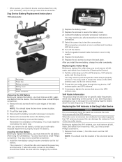
... be used only on specific radio frequencies, which vary depending on the GPS antenna case, but do not disturb the sealant opposite the VHF antenna, because this product. You may need to secure the battery cover. 4 Connect the battery connector and power connector. See the product packaging or go near other accessories. Dog Device Battery Replacement Instructions T5 Components À Back plate Á Power key  Battery connector à Battery cover Ä Battery Å Power connector Removing...
... be used only on specific radio frequencies, which vary depending on the GPS antenna case, but do not disturb the sealant opposite the VHF antenna, because this product. You may need to secure the battery cover. 4 Connect the battery connector and power connector. See the product packaging or go near other accessories. Dog Device Battery Replacement Instructions T5 Components À Back plate Á Power key  Battery connector à Battery cover Ä Battery Å Power connector Removing...

Owner's Manual (Astro 320, T 5)
Page 18
... maximum rate of the antenna from the original path of the waypoint). Your device must be connected to appear. Your device must be connected to remove the old antenna. 5 Loop the antenna guide around the collar strap, and thread the new VHF antenna through the guide. You must be viewed as a planned or set route. Overall Avg. : The average speed while moving and stopped since the last reset.
... maximum rate of the antenna from the original path of the waypoint). Your device must be connected to appear. Your device must be connected to remove the old antenna. 5 Loop the antenna guide around the collar strap, and thread the new VHF antenna through the guide. You must be viewed as a planned or set route. Overall Avg. : The average speed while moving and stopped since the last reset.

Owner's Manual (Astro 320, T 5)
Page 20
...7, 8 downloading 7 settings 10 GPS 8 settings 9 H hunting and fishing times 7 I icons 3 K keyboard 2 keys 1 locking 1 L line-of measure 9 updates, software 10 USB connector 1 disconnecting 12 mass storage mode 11 transferring files 11 user data, deleting 12 V VHF antenna 13 virb remote 8 W WAAS 9 waypoints 4, 6, 7 deleting 5 editing 4 navigating 4 projecting 5 saving 4 Z zooming, maps 2 Index See routes troubleshooting 15 bark detection 15 dog signals 15 U unit ID 10 units of -sight radio communication 4 locking, keys 1 M main menu, customizing 8 maps 4, 5 data fields 6 navigation 6 optional...
...7, 8 downloading 7 settings 10 GPS 8 settings 9 H hunting and fishing times 7 I icons 3 K keyboard 2 keys 1 locking 1 L line-of measure 9 updates, software 10 USB connector 1 disconnecting 12 mass storage mode 11 transferring files 11 user data, deleting 12 V VHF antenna 13 virb remote 8 W WAAS 9 waypoints 4, 6, 7 deleting 5 editing 4 navigating 4 projecting 5 saving 4 Z zooming, maps 2 Index See routes troubleshooting 15 bark detection 15 dog signals 15 U unit ID 10 units of -sight radio communication 4 locking, keys 1 M main menu, customizing 8 maps 4, 5 data fields 6 navigation 6 optional...


