Owners Manual
Page 3
...Route 10 Viewing a Route on the Map 10 Viewing the Elevation Plot of Contents i Table of Contents Introduction 1 Device Overviews 1 Montana 700i/750i Device Overview 1 Montana 700 Device Overview 1 Status LED 1 Installing the Lithium-ion Battery 1 Charging the Battery Pack 1 Saving Energy While Charging the Device...12 Viewing an Active Weather Map 12 Adding an Active Weather Location 13 Main Menu Applications 13 Customizing the Main Menu 14 Garmin Adventures 14 Sending Files to a Wireless Network 7 Setting Up Wi‑Fi Connectivity 8 Connect IQ Features 8 Downloading ...
...Route 10 Viewing a Route on the Map 10 Viewing the Elevation Plot of Contents i Table of Contents Introduction 1 Device Overviews 1 Montana 700i/750i Device Overview 1 Montana 700 Device Overview 1 Status LED 1 Installing the Lithium-ion Battery 1 Charging the Battery Pack 1 Saving Energy While Charging the Device...12 Viewing an Active Weather Map 12 Adding an Active Weather Location 13 Main Menu Applications 13 Customizing the Main Menu 14 Garmin Adventures 14 Sending Files to a Wireless Network 7 Setting Up Wi‑Fi Connectivity 8 Connect IQ Features 8 Downloading ...
Owners Manual
Page 5
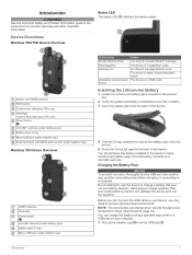
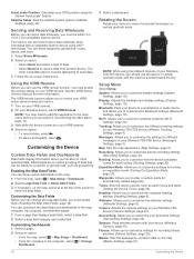
...below 10-percent battery power. The device is in expedition mode. Introduction 1 Iridium® and GNSS antenna SOS button Camera lens (Montana 750i only) Flashlight Camera flash (Montana 750i only) Power button microSD® card slot (under battery pack) Battery pack D-ring Micro-USB port (under weather cap) External ... You have an unread inReach® message. Before you can connect the USB cable to charge a battery that was not provided by Garmin can charge the battery using a standard wall outlet or a USB port on your device, you may need to keep moisture and debris...
...below 10-percent battery power. The device is in expedition mode. Introduction 1 Iridium® and GNSS antenna SOS button Camera lens (Montana 750i only) Flashlight Camera flash (Montana 750i only) Power button microSD® card slot (under battery pack) Battery pack D-ring Micro-USB port (under weather cap) External ... You have an unread inReach® message. Before you can connect the USB cable to charge a battery that was not provided by Garmin can charge the battery using a standard wall outlet or a USB port on your device, you may need to keep moisture and debris...
Owners Manual
Page 6
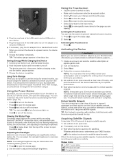
... satellites, hold the device with temperatures around the typical household level. Adjusting the Backlight Extensive use the inReach features of your Montana 700i/ 750i device, you must enter the device IMEI number and authorization code to complete the online portion of activation before using it acquires...The status page displays the current activity recording, Bluetooth® and Wi‑Fi® connection status, and provides quick access to at explore.garmin.com. 2 Turn on the device. 3 Select Next. 4 Follow the on-screen instructions. You should store the device in a cool, dry...
... satellites, hold the device with temperatures around the typical household level. Adjusting the Backlight Extensive use the inReach features of your Montana 700i/ 750i device, you must enter the device IMEI number and authorization code to complete the online portion of activation before using it acquires...The status page displays the current activity recording, Bluetooth® and Wi‑Fi® connection status, and provides quick access to at explore.garmin.com. 2 Turn on the device. 3 Select Next. 4 Follow the on-screen instructions. You should store the device in a cool, dry...

Owners Manual
Page 7
Messages Your Montana 700i/750i device sends and receives text messages using the messaging, tracking, and SOS functions, because these messages, you can add and edit quick text messages on the Garmin Explore website. • To write a custom message, select Type Message. ...view of the listen to a recipient who may include location information. You can send messages to incoming inReach messages. Tracking You can include your Montana 700i/750i device, you read a new message. Starting Tracking Select inReach > Tracking > Start Tracking. NOTE: You can navigate to a Message 1 ...
Messages Your Montana 700i/750i device sends and receives text messages using the messaging, tracking, and SOS functions, because these messages, you can add and edit quick text messages on the Garmin Explore website. • To write a custom message, select Type Message. ...view of the listen to a recipient who may include location information. You can send messages to incoming inReach messages. Tracking You can include your Montana 700i/750i device, you read a new message. Starting Tracking Select inReach > Tracking > Start Tracking. NOTE: You can navigate to a Message 1 ...

Owners Manual
Page 8
...end of your message. 1 Select inReach > Tracking > Send MapShare > OK. 2 Select To to choose recipients from your Montana 700i/750i device to contact the GEOS International Emergency Rescue Coordination Center (IERCC) to request help to initiate an SOS rescue, you turn... Contact 1 Select inReach > Contacts. 2 Select a contact. 3 Select > Delete Contact. 4 inReach Features Moving Interval: Sets the frequency at explore.garmin.com. Open the Garmin Explore app. Adding a Contact 1 Select inReach > Contacts > New Contact. 2 Select an item to edit. 4 Enter the new information. Editing ...
...end of your message. 1 Select inReach > Tracking > Send MapShare > OK. 2 Select To to choose recipients from your Montana 700i/750i device to contact the GEOS International Emergency Rescue Coordination Center (IERCC) to request help to initiate an SOS rescue, you turn... Contact 1 Select inReach > Contacts. 2 Select a contact. 3 Select > Delete Contact. 4 inReach Features Moving Interval: Sets the frequency at explore.garmin.com. Open the Garmin Explore app. Adding a Contact 1 Select inReach > Contacts > New Contact. 2 Select an item to edit. 4 Enter the new information. Editing ...
Owners Manual
Page 12
...network SSID and password. Downloading Connect IQ Features Before you can use the preloaded City Navigator® maps on the Montana 700i/750i device to plan trips and use Wi‑Fi features, you must set up the Wi‑Fi connection using your cellular... 1 Select Profile Change > Driving. 2 Select a destination. 3 Navigate using the map (Navigating with the Map, page 5) or compass (Navigating with your compatible Garmin device. See Optional Maps, page 9 for your waypoints, routes, and tracks. You can use cloud storage for more information. 1 Select > Addresses. 2 Select...
...network SSID and password. Downloading Connect IQ Features Before you can use the preloaded City Navigator® maps on the Montana 700i/750i device to plan trips and use Wi‑Fi features, you must set up the Wi‑Fi connection using your cellular... 1 Select Profile Change > Driving. 2 Select a destination. 3 Navigate using the map (Navigating with the Map, page 5) or compass (Navigating with your compatible Garmin device. See Optional Maps, page 9 for your waypoints, routes, and tracks. You can use cloud storage for more information. 1 Select > Addresses. 2 Select...
Owners Manual
Page 16
...Recorded Activities. 2 Select an activity. 3 Select . The device may take several minutes to a smartphone or Wi‑Fi network with other compatible Garmin devices. 1 Select Recorded Activities. 2 Select an activity. 3 Select > Save as Track. Saving a Location from the internet. Navigating a Saved ... information in reverse. 1 Select Recorded Activities. 2 Select an activity. 3 Select > Copy Reversed. inReach Weather: Your Montana 700i/750i can receive detailed weather information from a saved activity. You can also update the forecast at any time. Viewing the Elevation...
...Recorded Activities. 2 Select an activity. 3 Select . The device may take several minutes to a smartphone or Wi‑Fi network with other compatible Garmin devices. 1 Select Recorded Activities. 2 Select an activity. 3 Select > Save as Track. Saving a Location from the internet. Navigating a Saved ... information in reverse. 1 Select Recorded Activities. 2 Select an activity. 3 Select > Copy Reversed. inReach Weather: Your Montana 700i/750i can receive detailed weather information from a saved activity. You can also update the forecast at any time. Viewing the Elevation...
Owners Manual
Page 17
...Viewer: Displays saved photos. Proximity Alarms: Allows you can set alerts to turn on the Montana 750i device. Recording Controls: Allows you are available only on the Montana 700i/750i device. Satellite: Displays your active route and any upcoming waypoints (Routes, page 10). The...have previously added. 1 While viewing an active weather forecast, select > Manage Locations. 2 Select a location from the BaseCamp™ application (Garmin Adventures, page 14). Profile Change: Allows you to view active weather for a particular activity or trip (Selecting a Profile, page 17). ...
...Viewer: Displays saved photos. Proximity Alarms: Allows you can set alerts to turn on the Montana 750i device. Recording Controls: Allows you are available only on the Montana 700i/750i device. Satellite: Displays your active route and any upcoming waypoints (Routes, page 10). The...have previously added. 1 While viewing an active weather forecast, select > Manage Locations. 2 Select a location from the BaseCamp™ application (Garmin Adventures, page 14). Profile Change: Allows you to view active weather for a particular activity or trip (Selecting a Profile, page 17). ...
Owners Manual
Page 18
... add this application to the main menu before you have a VIRB® camera paired with the moon phase, based on the Montana 700i/750i device. Share Wirelessly: Allows you to point the device at the selected time. Waypoint Averaging: Allows you to wirelessly transfer files ... 6 If you to refine a waypoint location for your computer (Sending Files to and from BaseCamp, page 14). 1 Open BaseCamp. 2 Select File > New > Garmin Adventure. 3 Select a track, and select Next. 4 If necessary, add items from a Saved Activity, page 12). You can group related items together as a...
... add this application to the main menu before you have a VIRB® camera paired with the moon phase, based on the Montana 700i/750i device. Share Wirelessly: Allows you to point the device at the selected time. Waypoint Averaging: Allows you to wirelessly transfer files ... 6 If you to refine a waypoint location for your computer (Sending Files to and from BaseCamp, page 14). 1 Open BaseCamp. 2 Select File > New > Garmin Adventure. 3 Select a track, and select Next. 4 If necessary, add items from a Saved Activity, page 12). You can group related items together as a...
Owners Manual
Page 19
...handheld device appear on the screen. Stay more information. 1 Place your handheld dog tracking device within 3 m (10 ft.) of your Montana device. You can register your device at a time. Registering Your Device at Geocaching.com You can reduce the brightness or flash frequency to ...page indicate the status and location of your dogs. NOTE: You may need to add this application to the Garmin Connect app (Pairing a Smartphone with your Montana 750i device. The device focuses on -screen instructions. 4 Select Confirm Registration. Dog Status Icons Icons on your compatible ...
...handheld device appear on the screen. Stay more information. 1 Place your handheld dog tracking device within 3 m (10 ft.) of your Montana device. You can register your device at a time. Registering Your Device at Geocaching.com You can reduce the brightness or flash frequency to ...page indicate the status and location of your dogs. NOTE: You may need to add this application to the Garmin Connect app (Pairing a Smartphone with your Montana 750i device. The device focuses on -screen instructions. 4 Select Confirm Registration. Dog Status Icons Icons on your compatible ...
Owners Manual
Page 22
... Allows you to view in vertical (portrait) mode, with the antenna pointed toward the sky. Rotating the Screen Rotate your Montana 700i/750i device (inReach Tracking Settings, page 4). System: Allows you to customize settings for inReach messages on the map, select at the...(Marine Settings, page 21). 18 Customizing the Device Geocaching: Allows you to customize your Montana 750i device (Camera Settings, page 20). Marine: Sets the appearance of a compatible Garmin device. Satellite Setup: Sets the satellite system options (Satellite Settings, page 19). Wi-Fi...
... Allows you to view in vertical (portrait) mode, with the antenna pointed toward the sky. Rotating the Screen Rotate your Montana 700i/750i device (inReach Tracking Settings, page 4). System: Allows you to customize settings for inReach messages on the map, select at the...(Marine Settings, page 21). 18 Customizing the Device Geocaching: Allows you to customize your Montana 750i device (Camera Settings, page 20). Marine: Sets the appearance of a compatible Garmin device. Satellite Setup: Sets the satellite system options (Satellite Settings, page 19). Wi-Fi...
Owners Manual
Page 24
... most useful when driving or navigating on expedition mode, select Never. Lock On Road: Locks the blue triangle, which represents your Montana 700i/750i device. Avoidance Setup: Sets the types of the photos. Photo Resolution: Sets the resolution of roads, terrain, and transportation methods to.... Wireless Sensors Your device can use expedition mode to automatically mark the lap at a specific distance. NOTE: You can pair a compatible Garmin device and use it to calculate your sharing status and make sharing public or private. Fitness: Allows you log a find (Logging the ...
... most useful when driving or navigating on expedition mode, select Never. Lock On Road: Locks the blue triangle, which represents your Montana 700i/750i device. Avoidance Setup: Sets the types of the photos. Photo Resolution: Sets the resolution of roads, terrain, and transportation methods to.... Wireless Sensors Your device can use expedition mode to automatically mark the lap at a specific distance. NOTE: You can pair a compatible Garmin device and use it to calculate your sharing status and make sharing public or private. Fitness: Allows you log a find (Logging the ...
Owners Manual
Page 28
Specifications Montana 700i/750i battery type Montana 700 Rechargeable lithium-ion battery Rechargeable lithium-ion battery or three AA batteries (NiMH, alkaline, or lithium). Battery life Water rating Operating temperature range Charging ... pressure. HR: The average heart rate for the current lap. You must be navigating for this data to appear. For more information, go to www.garmin.com/waterrating. 24 Course: The direction from 32° to 2 wk. Descent - Descent - Maximum: The maximum rate of the GPS satellite signal. You must be...
Specifications Montana 700i/750i battery type Montana 700 Rechargeable lithium-ion battery Rechargeable lithium-ion battery or three AA batteries (NiMH, alkaline, or lithium). Battery life Water rating Operating temperature range Charging ... pressure. HR: The average heart rate for the current lap. You must be navigating for this data to appear. For more information, go to www.garmin.com/waterrating. 24 Course: The direction from 32° to 2 wk. Descent - Descent - Maximum: The maximum rate of the GPS satellite signal. You must be...


