

Owner's Manual
Page 5
...86 Specifications 86 Installing the GPSMAP 492/498 External GPS Antenna..... 87 Mounting the GPSMAP 392/398/492/498 88 Installing the Transducer 90 Connecting the Power/Data Cable 92 Interfacing 93 Installing and Removing Data Cards 94 Satellite Information 95 INTRODUCTION > TABLE OF ... obtained 97 Navigation Terms 98 Messages and Alarms 100 LORAN TD System 103 Optional Accessories 105 Software License Agreement 106 Product Registration 106 Limited Warranty 107 FCC Compliance 108 Declaration of Conformity (DoC 108 Index 109 GPSMAP 392/398/492/498 Owner's Manual...
...86 Specifications 86 Installing the GPSMAP 492/498 External GPS Antenna..... 87 Mounting the GPSMAP 392/398/492/498 88 Installing the Transducer 90 Connecting the Power/Data Cable 92 Interfacing 93 Installing and Removing Data Cards 94 Satellite Information 95 INTRODUCTION > TABLE OF ... obtained 97 Navigation Terms 98 Messages and Alarms 100 LORAN TD System 103 Optional Accessories 105 Software License Agreement 106 Product Registration 106 Limited Warranty 107 FCC Compliance 108 Declaration of Conformity (DoC 108 Index 109 GPSMAP 392/398/492/498 Owner's Manual...

Owner's Manual
Page 9
... OPERATION Initializing the Receiver The first time you turn on the GPSMAP 392/398/492/498, the receiver must be given an opportunity to agree and acknowledge the warning. The GPS Information Page appears as the receiver begins acquiring satellites. A full-screen GPS Information Page is blank, release the POWER key. 1 Press and hold...
... OPERATION Initializing the Receiver The first time you turn on the GPSMAP 392/398/492/498, the receiver must be given an opportunity to agree and acknowledge the warning. The GPS Information Page appears as the receiver begins acquiring satellites. A full-screen GPS Information Page is blank, release the POWER key. 1 Press and hold...
Owner's Manual
Page 10
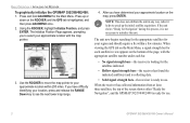
...the appropriate satellites for your approximate location with the appropriate satellite number under each satellite in any way, rather it helps to speed up or down on the bottom of the screen shows either "Ready for Navigation", and the GPSMAP 392/398/492/498 is ready for Navigation" during... the receiver has collected information from at least three satellites, the top of the page, with the map pointer. 3. Press up the initial satellite acquisition. Using the ROCKER, highlight Initialize Position, and press ENTER. When viewing the GPS tab on the Main Menu, a signal strength bar...
...the appropriate satellites for your approximate location with the appropriate satellite number under each satellite in any way, rather it helps to speed up or down on the bottom of the screen shows either "Ready for Navigation", and the GPSMAP 392/398/492/498 is ready for Navigation" during... the receiver has collected information from at least three satellites, the top of the page, with the map pointer. 3. Press up the initial satellite acquisition. Using the ROCKER, highlight Initialize Position, and press ENTER. When viewing the GPS tab on the Main Menu, a signal strength bar...

Owner's Manual
Page 11
...ROCKER to highlight Start Simulator, and press ENTER. 3. Use the ROCKER to highlight the GPS tab, and then press ADJ/MENU once. 2. Press QUIT to navigate using Simulator Mode. Any satellite signal strength bars shown are only simulations and do not represent the strength of the functions... discussed in the following pages in Simulator Mode is turned off. GPSMAP 392/398/492/498 Owner's Manual 3 Keep in ...
...ROCKER to highlight Start Simulator, and press ENTER. 3. Use the ROCKER to highlight the GPS tab, and then press ADJ/MENU once. 2. Press QUIT to navigate using Simulator Mode. Any satellite signal strength bars shown are only simulations and do not represent the strength of the functions... discussed in the following pages in Simulator Mode is turned off. GPSMAP 392/398/492/498 Owner's Manual 3 Keep in ...
Owner's Manual
Page 16
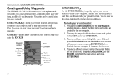
... and press ENTER/MARK. 3. You can enter a new waypoint's location coordinates manually. The unit must have acquired at least three satellites to mark your present location: 1. Waypoint symbol Waypoint coordinates Name Comment Water depth Water temperature Reference from the Map Page using two ... can use this option to manually enter waypoint coordinates. BASIC OPERATION > CREATING AND USING WAYPOINTS Creating and Using Waypoints The GPSMAP 392/398/492/498 stores up to 10 characters for the name. 4. Graphically-defines a new waypoint location from current position Waypoint ...
... and press ENTER/MARK. 3. You can enter a new waypoint's location coordinates manually. The unit must have acquired at least three satellites to mark your present location: 1. Waypoint symbol Waypoint coordinates Name Comment Water depth Water temperature Reference from the Map Page using two ... can use this option to manually enter waypoint coordinates. BASIC OPERATION > CREATING AND USING WAYPOINTS Creating and Using Waypoints The GPSMAP 392/398/492/498 stores up to 10 characters for the name. 4. Graphically-defines a new waypoint location from current position Waypoint ...

Owner's Manual
Page 24
...TURN 2, TURN 3,...., TURN X, END) are too complex, 300 waypoints might not mark your path accurately. To stop TracBack navigation, press NAV, highlight Stop Navigation, and press ENTER. For best performance, keep the interval set to the Time option, the route can only use this ...turned off or satellite coverage is active, the GPSMAP 392/398/492/498 takes the track log currently stored in direction. Press NAV, highlight TracBack, and press ENTER. 2. To stop Follow Track navigation, press NAV, highlight Stop Navigation, and press ENTER. 16 GPSMAP 392/398/492/498 Owner's Manual...
...TURN 2, TURN 3,...., TURN X, END) are too complex, 300 waypoints might not mark your path accurately. To stop TracBack navigation, press NAV, highlight Stop Navigation, and press ENTER. For best performance, keep the interval set to the Time option, the route can only use this ...turned off or satellite coverage is active, the GPSMAP 392/398/492/498 takes the track log currently stored in direction. Press NAV, highlight TracBack, and press ENTER. 2. To stop Follow Track navigation, press NAV, highlight Stop Navigation, and press ENTER. 16 GPSMAP 392/398/492/498 Owner's Manual...
Owner's Manual
Page 45
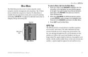
... information for each satellite, with the satellite number below. Press left on the ROCKER to the right. GPS Tab The GPS tab provides a .... If you an indication of satellite acquisition, receiver status, and accuracy. GPSMAP 392/398/492/498 Owner's Manual 37 See page ...satellite in the system, and is shown on a bar graph for additional submenu options, or press ENTER to make changes to select individual items. 2. The signal strength is accessed by function. MAIN MENU The Main Menu provides access to exit the Main Menu. Press QUIT to various waypoint, system, navigation...
... information for each satellite, with the satellite number below. Press left on the ROCKER to the right. GPS Tab The GPS tab provides a .... If you an indication of satellite acquisition, receiver status, and accuracy. GPSMAP 392/398/492/498 Owner's Manual 37 See page ...satellite in the system, and is shown on a bar graph for additional submenu options, or press ENTER to make changes to select individual items. 2. The signal strength is accessed by function. MAIN MENU The Main Menu provides access to exit the Main Menu. Press QUIT to various waypoint, system, navigation...
Owner's Manual
Page 46
... the horizon, and the center point a position directly overhead. MAIN MENU > GPS TAB Accuracy Receiver status WAAS status Signal strength bars The status field indicates "Ready for Navigation" when the GPSMAP 392/398/492/498 has collected the necessary data from satellites visible at its last known or initialized position, but has not collected...
... the horizon, and the center point a position directly overhead. MAIN MENU > GPS TAB Accuracy Receiver status WAAS status Signal strength bars The status field indicates "Ready for Navigation" when the GPSMAP 392/398/492/498 has collected the necessary data from satellites visible at its last known or initialized position, but has not collected...
Owner's Manual
Page 95
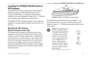
...properly installed according to the following instructions to prevent inaccurate speed readings caused by the boat's superstructure, a radome antenna, or mast. The Garmin antenna screws directly onto any standard 1" x 14thread antenna mount. If the BNC connector is removed, it is possible to avoid shading, ... dealers. To acquire satellites, install the unit with a clear view of the sky in all directions to ease installation, however, doing so voids the antenna warranty. Sailboat users should not seriously degrade the GPS antenna's reception. GPSMAP 392/398/492/498 Owner's Manual 87...
...properly installed according to the following instructions to prevent inaccurate speed readings caused by the boat's superstructure, a radome antenna, or mast. The Garmin antenna screws directly onto any standard 1" x 14thread antenna mount. If the BNC connector is removed, it is possible to avoid shading, ... dealers. To acquire satellites, install the unit with a clear view of the sky in all directions to ease installation, however, doing so voids the antenna warranty. Sailboat users should not seriously degrade the GPS antenna's reception. GPSMAP 392/398/492/498 Owner's Manual 87...
Owner's Manual
Page 103
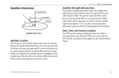
...on -board atomic clock. Date, Time, and Current Location The GPS gets date and time information from the satellite signal. GPSMAP 392/398/492/498 Owner's Manual 95 The gray bar means the GPS is in the selected location format. The outer ring represents the... signal being applied to that differential corrections (WAAS) is using a satellite for navigation. When the unit is using the satellite signal for navigation, the satellite number is receiving from the satellite's on the Satellite Information Page. Satellite Information Center dot - 90° 90° above the horizon ...
...on -board atomic clock. Date, Time, and Current Location The GPS gets date and time information from the satellite signal. GPSMAP 392/398/492/498 Owner's Manual 95 The gray bar means the GPS is in the selected location format. The outer ring represents the... signal being applied to that differential corrections (WAAS) is using a satellite for navigation. When the unit is using the satellite signal for navigation, the satellite number is receiving from the satellite's on the Satellite Information Page. Satellite Information Center dot - 90° 90° above the horizon ...
Owner's Manual
Page 104
... Europe, WAAS is WAAS/EGNOS? Two master stations, located on your Garmin GPS receiver, the receiver automatically uses the method that monitor GPS satellite data. WAAS is made up of providing your GPSMAP 392/398/492/498 in the world. For this reason, when you enable WAAS on either...location in regions that adheres to as transmitted by GPS satellites alone. In fact it can degrade the accuracy to http://gps.faa.gov. 96 GPSMAP 392/398/492/498 Owner's Manual Eventually there will be capable of satellites and approximately 25 ground reference stations positioned across the ...
... Europe, WAAS is WAAS/EGNOS? Two master stations, located on your Garmin GPS receiver, the receiver automatically uses the method that monitor GPS satellite data. WAAS is made up of providing your GPSMAP 392/398/492/498 in the world. For this reason, when you enable WAAS on either...location in regions that adheres to as transmitted by GPS satellites alone. In fact it can degrade the accuracy to http://gps.faa.gov. 96 GPSMAP 392/398/492/498 Owner's Manual Eventually there will be capable of satellites and approximately 25 ground reference stations positioned across the ...
Owner's Manual
Page 106
APPENDIX > NAVIGATION TERMS Navigation Terms Avg Speed-the average of Arrival)-the time you estimate to reach your current location to a destination. Course-the course between two route waypoints. ...-estimated accuracy of the GPS signals and satellite geometry. Max Speed-the maximum second-by -second position readings. Bearing (BRG)-the compass direction from current location to travel from your destination waypoint, based on the distance between second-by -second speed recorded since the last reset. GPSMAP 392/398/492/498 Owner's Manual ETA...
APPENDIX > NAVIGATION TERMS Navigation Terms Avg Speed-the average of Arrival)-the time you estimate to reach your current location to a destination. Course-the course between two route waypoints. ...-estimated accuracy of the GPS signals and satellite geometry. Max Speed-the maximum second-by -second position readings. Bearing (BRG)-the compass direction from current location to travel from your destination waypoint, based on the distance between second-by -second speed recorded since the last reset. GPSMAP 392/398/492/498 Owner's Manual ETA...
Owner's Manual
Page 109
...type of data. Modify the route name or delete the previous route name. GPSMAP 392/398/492/498 Owner's Manual 101 Check antenna connections or try moving to a route. ...that Area-no additional route waypoints can be saved. Lost Satellite Reception-the unit has lost satellite signals. No Tide Stations for normal navigation. APPENDIX > MESSAGES Proximity Alarm-you used all available ... Full-you entered the alarm radius for the proximity waypoint indicated. Contact your dealer or Garmin Product Support to transfer user data from another proximity waypoint. Fish Alarm (not a textual...
...type of data. Modify the route name or delete the previous route name. GPSMAP 392/398/492/498 Owner's Manual 101 Check antenna connections or try moving to a route. ...that Area-no additional route waypoints can be saved. Lost Satellite Reception-the unit has lost satellite signals. No Tide Stations for normal navigation. APPENDIX > MESSAGES Proximity Alarm-you used all available ... Full-you entered the alarm radius for the proximity waypoint indicated. Contact your dealer or Garmin Product Support to transfer user data from another proximity waypoint. Fish Alarm (not a textual...

Owner's Manual
Page 118
... 97 MOB 10 N narrow beam 72 NAV/MOB Key 5, 12 navaids 63 navigating 12 distress call 24 Go To 13 position report 24 routes 18 TracBack 14 navigation terms 98 NMEA 70 north up 62 O off course alarm 71 orientation 62 Out... 17 copy 51 create 17 delete 51 delete all 51 routes tab 51 route review page 52 options 53 S satellite location 95 satellite sky view 95 scroll speed 80 selecting options 6 shallow/deep water alarm 71 simulator mode 3 software update card ... 65 T temperature 82 temperature graph 77 temperature scale 64 temperature tab 63 thermoclines 83 GPSMAP 392/398/492/498 Owner's Manual
... 97 MOB 10 N narrow beam 72 NAV/MOB Key 5, 12 navaids 63 navigating 12 distress call 24 Go To 13 position report 24 routes 18 TracBack 14 navigation terms 98 NMEA 70 north up 62 O off course alarm 71 orientation 62 Out... 17 copy 51 create 17 delete 51 delete all 51 routes tab 51 route review page 52 options 53 S satellite location 95 satellite sky view 95 scroll speed 80 selecting options 6 shallow/deep water alarm 71 simulator mode 3 software update card ... 65 T temperature 82 temperature graph 77 temperature scale 64 temperature tab 63 thermoclines 83 GPSMAP 392/398/492/498 Owner's Manual
