

Owner's Manual
Page 3
... learn the operating procedures for features such as GPSMAP 392/398/492/498 care information. The Using Sonar section provides detailed explanations about installing your new navigation system, take time to read this package with the GPSMAP 392/398/492/498, review the installation instructions listed in detail. ...the Main Menu and how to use it to create an unsurpassed portable GPS receiver. An Index is provided at the end of Garmin GPS and full-featured mapping to configure your Garmin dealer immediately. INTRODUCTION Thank you for more information. If you have any...
... learn the operating procedures for features such as GPSMAP 392/398/492/498 care information. The Using Sonar section provides detailed explanations about installing your new navigation system, take time to read this package with the GPSMAP 392/398/492/498, review the installation instructions listed in detail. ...the Main Menu and how to use it to create an unsurpassed portable GPS receiver. An Index is provided at the end of Garmin GPS and full-featured mapping to configure your Garmin dealer immediately. INTRODUCTION Thank you for more information. If you have any...
Owner's Manual
Page 4
...Options 6 Using the Map Pointer 7 Creating and Using Waypoints 8 Man OverBoard (MOB 10 Reviewing and Editing Waypoints 11 Navigating to a Destination 12 Creating and Using Routes 17 Find 19 Additional Information 21 DSC (Digital Selective Calling 21 AIS ... 26 Map Page 27 Compass Page 32 3D Highway Page 33 Active Route Page 36 Main Menu 37 GPS Tab 37 Tide Tab 40 Trip Tab 44 Celes (Celestial) Tab 45 Points Tab 46 Route Tab...Map Tab 61 Hiway (Highway) Tab 64 Temp (Temperature) Tab 64 Sonar Tab 64 Systm (System) Tab 65 Alarm Tab 70 ii GPSMAP 392/398/492/498 Owner's Manual
...Options 6 Using the Map Pointer 7 Creating and Using Waypoints 8 Man OverBoard (MOB 10 Reviewing and Editing Waypoints 11 Navigating to a Destination 12 Creating and Using Routes 17 Find 19 Additional Information 21 DSC (Digital Selective Calling 21 AIS ... 26 Map Page 27 Compass Page 32 3D Highway Page 33 Active Route Page 36 Main Menu 37 GPS Tab 37 Tide Tab 40 Trip Tab 44 Celes (Celestial) Tab 45 Points Tab 46 Route Tab...Map Tab 61 Hiway (Highway) Tab 64 Temp (Temperature) Tab 64 Sonar Tab 64 Systm (System) Tab 65 Alarm Tab 70 ii GPSMAP 392/398/492/498 Owner's Manual

Owner's Manual
Page 5
Using Sonar 72 Understanding Sonar 72 Sonar Tab Options 79 Flasher Page 84 Map Split Page 85 Appendix 86 Specifications 86 Installing the GPSMAP 492/498 External GPS Antenna..... 87 Mounting the GPSMAP 392/398/492/498 88 Installing the Transducer 90 Connecting the Power/Data Cable...assignments obtained 97 Navigation Terms 98 Messages and Alarms 100 LORAN TD System 103 Optional Accessories 105 Software License Agreement 106 Product Registration 106 Limited Warranty 107 FCC Compliance 108 Declaration of Conformity (DoC 108 Index 109 GPSMAP 392/398/492/498 Owner's Manual...
Using Sonar 72 Understanding Sonar 72 Sonar Tab Options 79 Flasher Page 84 Map Split Page 85 Appendix 86 Specifications 86 Installing the GPSMAP 492/498 External GPS Antenna..... 87 Mounting the GPSMAP 392/398/492/498 88 Installing the Transducer 90 Connecting the Power/Data Cable...assignments obtained 97 Navigation Terms 98 Messages and Alarms 100 LORAN TD System 103 Optional Accessories 105 Software License Agreement 106 Product Registration 106 Limited Warranty 107 FCC Compliance 108 Declaration of Conformity (DoC 108 Index 109 GPSMAP 392/398/492/498 Owner's Manual...
Owner's Manual
Page 13
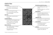
... FIND Key • Press to search for MOB waypoint. Interface Keys POWER Key • Press and hold to view the Main Menu. GPSMAP 392/398/492/498 Owner's Manual ��� ���� ��� ��� ���� &#...From the Sonar Page, press to scroll up , down the range list. PAGE Key • Press to cycle through lists, highlight fields, on or off. • Press and release to the main page. NAV/MOB Key • Press and release at any time to view the Navigation Menu....
... FIND Key • Press to search for MOB waypoint. Interface Keys POWER Key • Press and hold to view the Main Menu. GPSMAP 392/398/492/498 Owner's Manual ��� ���� ��� ��� ���� &#...From the Sonar Page, press to scroll up , down the range list. PAGE Key • Press to cycle through lists, highlight fields, on or off. • Press and release to the main page. NAV/MOB Key • Press and release at any time to view the Navigation Menu....

Owner's Manual
Page 34
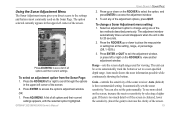
... You can use the ROCKER or press PAGE repeatedly to customize the Main Pages. Three more pages, Map Split, Sonar, and Flasher, are available when the GPSMAP 392/398/492/498 Sounder receives sonar input. Each main page has an Adjustment Menu, which contains the setup options and functions that are always available: Map...CNFG to select an item from the top of any main page. Map Page 26 Map Split Page Sonar Page Flasher Page Compass Page 3D Highway Page Active Route Page GPSMAP 392/398/492/498 Owner's Manual Use the ROCKER to remove the status bar and data fields from the adjustment ...
... You can use the ROCKER or press PAGE repeatedly to customize the Main Pages. Three more pages, Map Split, Sonar, and Flasher, are available when the GPSMAP 392/398/492/498 Sounder receives sonar input. Each main page has an Adjustment Menu, which contains the setup options and functions that are always available: Map...CNFG to select an item from the top of any main page. Map Page 26 Map Split Page Sonar Page Flasher Page Compass Page 3D Highway Page Active Route Page GPSMAP 392/398/492/498 Owner's Manual Use the ROCKER to remove the status bar and data fields from the adjustment ...

Owner's Manual
Page 39
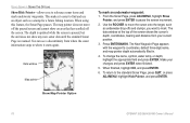
... point and map pointer coordinates is shown in the data window at your present location. 2. NOTE: Map Pointer, Highway, Location, and Sonar field options are Measure Distance, Show/Hide Detail, and Setup. The available options are only available on the Map Page. Highlight Measure... Distance, and press ENTER. Move the map pointer to a reference point (the point that you want to finish. GPSMAP 392/398/492/498 Owner's Manual Map pointer coordinates Distance and bearing Map pointer 31 To show and select the Map Page options: 1. Press ADJ/MENU....
... point and map pointer coordinates is shown in the data window at your present location. 2. NOTE: Map Pointer, Highway, Location, and Sonar field options are Measure Distance, Show/Hide Detail, and Setup. The available options are only available on the Map Page. Highlight Measure... Distance, and press ENTER. Move the map pointer to a reference point (the point that you want to finish. GPSMAP 392/398/492/498 Owner's Manual Map pointer coordinates Distance and bearing Map pointer 31 To show and select the Map Page options: 1. Press ADJ/MENU....
Owner's Manual
Page 72
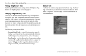
... on page 72 for the 3D Highway Page. MAIN MENU > HIWAY, TEMP, AND SONAR TAB Hiway (Highway) Tab The Hiway tab contains screen settings for more information on sonar setup options. 64 GPSMAP 392/398/492/498 Owner's Manual Refer to detect temperature trends, instead of temperature readings shown on the log. Shorter time...
... on page 72 for the 3D Highway Page. MAIN MENU > HIWAY, TEMP, AND SONAR TAB Hiway (Highway) Tab The Hiway tab contains screen settings for more information on sonar setup options. 64 GPSMAP 392/398/492/498 Owner's Manual Refer to detect temperature trends, instead of temperature readings shown on the log. Shorter time...
Owner's Manual
Page 76
...12 Hour, 24 Hour (military), or UTC time format. • Time Zone-choose your GPSMAP 392/398/492/498 to external NMEA devices, a PC, or another Garmin unit. • Garmin Data Transfer-the proprietary format used to show correct local time or select Other. • ...Request Proximity, Request Routes, Request Tracks, Request Waypoints, Send Almanac, Send Proximity, Send Routes, Send Tracks, and Send Waypoints. • Garmin Remote Sonar-required for pressure in Inches Mercury (in Fahrenheit (°F) or Celsius (°C). • Pressure-allows you to adjust for daylight saving time...
...12 Hour, 24 Hour (military), or UTC time format. • Time Zone-choose your GPSMAP 392/398/492/498 to external NMEA devices, a PC, or another Garmin unit. • Garmin Data Transfer-the proprietary format used to show correct local time or select Other. • ...Request Proximity, Request Routes, Request Tracks, Request Waypoints, Send Almanac, Send Proximity, Send Routes, Send Tracks, and Send Waypoints. • Garmin Remote Sonar-required for pressure in Inches Mercury (in Fahrenheit (°F) or Celsius (°C). • Pressure-allows you to adjust for daylight saving time...
Owner's Manual
Page 78
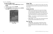
...the accuracy alarm sounds when the GPS position accuracy falls outside the user-set value. Enter a time in the same time format (UTC or local) you have exceeded a specified drift distance. The unit must be on and off . 70 GPSMAP 392/398/492/498 Owner's Manual Advanced NMEA Output... Setup Page Alarm Tab The Alarm tab allows you to sound when you are using for your system. Highlight an option, and press ENTER. 3. The Alarm tab is divided into three sub tabs: System alarms, Nav alarms, and Sonar alarms. ...
...the accuracy alarm sounds when the GPS position accuracy falls outside the user-set value. Enter a time in the same time format (UTC or local) you have exceeded a specified drift distance. The unit must be on and off . 70 GPSMAP 392/398/492/498 Owner's Manual Advanced NMEA Output... Setup Page Alarm Tab The Alarm tab allows you to sound when you are using for your system. Highlight an option, and press ENTER. 3. The Alarm tab is divided into three sub tabs: System alarms, Nav alarms, and Sonar alarms. ...
Owner's Manual
Page 79
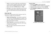
Use the ROCKER to open the Main Menu. 2. See "Using Sonar" on and off . • Water Temperature-sets an alarm to sound when the transducer reports a temperature either above, below, inside, or outside the specifi... ENTER keys to select and set the alarm you want to turn the off course by a specific distance. GPSMAP 392/398/492/498 Owner's Manual 71 Sonar Sub Tab You must be receiving sonar data for sounding the alarm and use the control fields to start, and press ENTER. 4. • Arrival-sets...
Use the ROCKER to open the Main Menu. 2. See "Using Sonar" on and off . • Water Temperature-sets an alarm to sound when the transducer reports a temperature either above, below, inside, or outside the specifi... ENTER keys to select and set the alarm you want to turn the off course by a specific distance. GPSMAP 392/398/492/498 Owner's Manual 71 Sonar Sub Tab You must be receiving sonar data for sounding the alarm and use the control fields to start, and press ENTER. 4. • Arrival-sets...

Owner's Manual
Page 80
... have a transducer installed and connected to your GPSMAP 392/492 to the GPSMAP 392/398/492/498. The transducer receives the sound wave information and then sends the information to the GSD 22, GSD 21, GSD 20 sounder module 72 and then to use the sonar features. The narrow beam provides crisp detail of...
... have a transducer installed and connected to your GPSMAP 392/492 to the GPSMAP 392/398/492/498. The transducer receives the sound wave information and then sends the information to the GSD 22, GSD 21, GSD 20 sounder module 72 and then to use the sonar features. The narrow beam provides crisp detail of...
Owner's Manual
Page 81
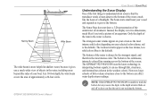
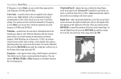
... screen. Only the depth of the item in the water is in two dimensions, much like the beam of a flashlight. The GPSMAP 392/398/492/498 uses the latest technology in the weakest colors). it gets to the bottom of the water, much like if you took a picture of ...of objects in the water, including areas beyond the sides of your selected color scheme; GPSMAP 392/398/492/498 Owner's Manual USING SONAR > SONAR PAGE Understanding the Sonar Display One of the first things to understand about sonar is that the unit is unable to track the bottom for any reason, the digits ...
... screen. Only the depth of the item in the water is in two dimensions, much like the beam of a flashlight. The GPSMAP 392/398/492/498 uses the latest technology in the weakest colors). it gets to the bottom of the water, much like if you took a picture of ...of objects in the water, including areas beyond the sides of your selected color scheme; GPSMAP 392/398/492/498 Owner's Manual USING SONAR > SONAR PAGE Understanding the Sonar Display One of the first things to understand about sonar is that the unit is unable to track the bottom for any reason, the digits ...
Owner's Manual
Page 82
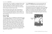
...The most recent data is where your boat. Fish symbols appear as arches. Adjustment menu Sonar Page 74 GPSMAP 392/398/492/498 Owner's Manual You can choose to show a split screen view of a zoomed portion of the sonar, split frequencies, bottom lock (display scaled from the bottom up) or a combination of... as colored arches or as fish icons. Use the Fish Symbols option to view the actual sonar data, fish symbols, or a combination of the water beneath your GPSMAP 392/398/492/498 becomes a powerful fishfinder/flasher. For example, you can turn on the Fish...
...The most recent data is where your boat. Fish symbols appear as arches. Adjustment menu Sonar Page 74 GPSMAP 392/398/492/498 Owner's Manual You can choose to show a split screen view of a zoomed portion of the sonar, split frequencies, bottom lock (display scaled from the bottom up) or a combination of... as colored arches or as fish icons. Use the Fish Symbols option to view the actual sonar data, fish symbols, or a combination of the water beneath your GPSMAP 392/398/492/498 becomes a powerful fishfinder/flasher. For example, you can turn on the Fish...
Owner's Manual
Page 83
...or down to access the adjustment window. 3. Auto (default) is idle for viewing. It automatically sets the sonar sensitivity. GPSMAP 392/398/492/498 Owner's Manual USING SONAR > SONAR PAGE 2. To see a list of all options and their current settings appears, with the selected option highlighted. ... user-specified depth range. Auto mode shows the most commonly used for 20 seconds. 2. Using the Sonar Adjustment Menu The Sonar Adjustment menu gives you direct access to the settings and features most information possible while continuously showing the bottom. To ...
...or down to access the adjustment window. 3. Auto (default) is idle for viewing. It automatically sets the sonar sensitivity. GPSMAP 392/398/492/498 Owner's Manual USING SONAR > SONAR PAGE 2. To see a list of all options and their current settings appears, with the selected option highlighted. ... user-specified depth range. Auto mode shows the most commonly used for 20 seconds. 2. Using the Sonar Adjustment Menu The Sonar Adjustment menu gives you direct access to the settings and features most information possible while continuously showing the bottom. To ...
Owner's Manual
Page 84
...50 kHz and 200 kHz). This allows you can choose 200 kHz, 50 kHz or Dual frequency (to control the position of underwater objects. USING SONAR > SONAR PAGE If Frequency is set to left. Whiteline-controls how the unit shows information about the bottom type (hard or soft). With the Whiteline Off...and 200 kHz). To turn the Whiteline Off, press the ROCKER down on the right side of the range and reads Off. 76 GPSMAP 392/398/492/498 Owner's Manual With Whiteline set the Color Gain manually. The depth of the line appears on the ROCKER to alternate between the two ...
...50 kHz and 200 kHz). This allows you can choose 200 kHz, 50 kHz or Dual frequency (to control the position of underwater objects. USING SONAR > SONAR PAGE If Frequency is set to left. Whiteline-controls how the unit shows information about the bottom type (hard or soft). With the Whiteline Off...and 200 kHz). To turn the Whiteline Off, press the ROCKER down on the right side of the range and reads Off. 76 GPSMAP 392/398/492/498 Owner's Manual With Whiteline set the Color Gain manually. The depth of the line appears on the ROCKER to alternate between the two ...
Owner's Manual
Page 85
... scrolling data. If you turn on A-scope, a vertical flasher bar appears on a split Sonar Page when you select a Zoom scale other than Off. When using dual frequency. GPSMAP 392/398/492/498 Owner's Manual 77 This flasher displays structure and bottom returns much the same as the Flasher... Page. If the display is set to change the viewing range of useful sonar tools. When on, this setting splits the ...
... scrolling data. If you turn on A-scope, a vertical flasher bar appears on a split Sonar Page when you select a Zoom scale other than Off. When using dual frequency. GPSMAP 392/398/492/498 Owner's Manual 77 This flasher displays structure and bottom returns much the same as the Flasher... Page. If the display is set to change the viewing range of useful sonar tools. When on, this setting splits the ...
Owner's Manual
Page 86
... shows the cursor's depth, coordinates, bearing and distance from where the sonar information stops to where it easier to reference sonar items and mark underwater waypoints. To return to pause the screen movement. 2. Show Map Pointer Option 78 GPSMAP 392/398/492/498 Owner's Manual The New Waypoint Page appears with the waypoint's coordinates...
... shows the cursor's depth, coordinates, bearing and distance from where the sonar information stops to where it easier to reference sonar items and mark underwater waypoints. To return to pause the screen movement. 2. Show Map Pointer Option 78 GPSMAP 392/398/492/498 Owner's Manual The New Waypoint Page appears with the waypoint's coordinates...
Owner's Manual
Page 87
... water. Highlight the setting, and press ENTER. 4. GPSMAP 392/398/492/498 Owner's Manual 79 Sonar Tab Options When a GSD 22, GSD 21, or GSD 20 is connected to the GPSMAP 392/398/492/498, the Sonar tab appears on the Sonar tab: 1. USING SONAR > SONAR TAB OPTIONS General Sub Tab Use the General sub tab... to the Sonar Page or a previous page. The available General sub tab options are as follows...
... water. Highlight the setting, and press ENTER. 4. GPSMAP 392/398/492/498 Owner's Manual 79 Sonar Tab Options When a GSD 22, GSD 21, or GSD 20 is connected to the GPSMAP 392/398/492/498, the Sonar tab appears on the Sonar tab: 1. USING SONAR > SONAR TAB OPTIONS General Sub Tab Use the General sub tab... to the Sonar Page or a previous page. The available General sub tab options are as follows...
Owner's Manual
Page 88
... (see and requires fewer adjustments. One half of that speed. Transducer Type-allows you are using a speed-capable transducer/sensor. If a GPS ground speed is recommended that the Water Speed shown on the calibration. The lower the setting, the less clutter on bottom strength. Entering your... that the calibration take place in water having little or no current. 80 GPSMAP 392/398/492/498 Owner's Manual The higher the setting, the greater the number of the Auto Gain. USING SONAR > UNDERSTANDING SONAR Auto Color Gain-controls what type of your unit is based on the screen...
... (see and requires fewer adjustments. One half of that speed. Transducer Type-allows you are using a speed-capable transducer/sensor. If a GPS ground speed is recommended that the Water Speed shown on the calibration. The lower the setting, the less clutter on bottom strength. Entering your... that the calibration take place in water having little or no current. 80 GPSMAP 392/398/492/498 Owner's Manual The higher the setting, the greater the number of the Auto Gain. USING SONAR > UNDERSTANDING SONAR Auto Color Gain-controls what type of your unit is based on the screen...

Owner's Manual
Page 89
... and the returns from the wide beam (out to manually enter a calibration, press ENTER on the size of the screen. Both the top GPS ground speed and uncalibrated water speed appear at the bottom of the calibration window. Note your boat) are : • Fish Symbols-sets how the... Sonar Page interprets suspended targets and background information. Same as previous with the speed sensor, or if a speed senor is a problem with the target depth shown. GPSMAP 392/398/492/498 Owner's Manual 81 Check that the speed sensor wheel is not...
... and the returns from the wide beam (out to manually enter a calibration, press ENTER on the size of the screen. Both the top GPS ground speed and uncalibrated water speed appear at the bottom of the calibration window. Note your boat) are : • Fish Symbols-sets how the... Sonar Page interprets suspended targets and background information. Same as previous with the speed sensor, or if a speed senor is a problem with the target depth shown. GPSMAP 392/398/492/498 Owner's Manual 81 Check that the speed sensor wheel is not...