
Owner's Manual
Page 2
...2642.9199 0808 2380000 (UK only) Fax 886/2.2642.9099 Fax 44/0870.8501251 All rights reserved. Visit the Garmin Web site (www.garmin.com) for current updates and supplemental information concerning the use and operation of this manual or any revision hereto is subject to change or improve... that any person or organization of this document is strictly prohibited. September 2006 Part Number 190-00653-00 Rev. Garmin®, GPSMAP®, AutoLocate® , UltraScroll®, TracBack®, BlueChart®, MapSource®, and BlueChart® g2TM are registered trademarks of...
...2642.9199 0808 2380000 (UK only) Fax 886/2.2642.9099 Fax 44/0870.8501251 All rights reserved. Visit the Garmin Web site (www.garmin.com) for current updates and supplemental information concerning the use and operation of this manual or any revision hereto is subject to change or improve... that any person or organization of this document is strictly prohibited. September 2006 Part Number 190-00653-00 Rev. Garmin®, GPSMAP®, AutoLocate® , UltraScroll®, TracBack®, BlueChart®, MapSource®, and BlueChart® g2TM are registered trademarks of...
Owner's Manual
Page 44
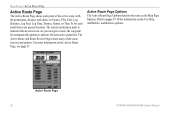
... the next active point first. Active Route Page 36 GPSMAP 392/398/492/498 Owner's Manual Active Route Page Options The Active Route Page Options function the same as the Map Page Options. As you navigate a route, the waypoint list automatically updates to pages 17-19 for each point of the active route...
... the next active point first. Active Route Page 36 GPSMAP 392/398/492/498 Owner's Manual Active Route Page Options The Active Route Page Options function the same as the Map Page Options. As you navigate a route, the waypoint list automatically updates to pages 17-19 for each point of the active route...
Owner's Manual
Page 46
... are being calculated in latitude, longitude, and elevation. • Ready for Navigation" when the GPSMAP 392/398/492/498 has collected the necessary data from satellites visible at its last known or initialized... position, but has not collected enough data to calculate a fix. • Ready for Navigation-at least three satellites have a current location fix. MAIN MENU > GPS... receiver's last known location. The unit then updates the location, date, and time.
... are being calculated in latitude, longitude, and elevation. • Ready for Navigation" when the GPSMAP 392/398/492/498 has collected the necessary data from satellites visible at its last known or initialized... position, but has not collected enough data to calculate a fix. • Ready for Navigation-at least three satellites have a current location fix. MAIN MENU > GPS... receiver's last known location. The unit then updates the location, date, and time.
Owner's Manual
Page 50
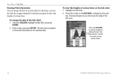
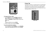
..., or move past the edge of the tide chart: 1. The day changes as you move the time bar in map pointer mode. 42 GPSMAP 392/398/492/498 Owner's Manual MAIN MENU > TIDE TAB Viewing Tide Information You can change the date to see tide heights at different times. Using the ROCKER... field, and press ENTER. 2. To view tide heights at various times. Enter a date, and press ENTER. Highlight the tide chart. 2. The tide chart is updated to show tide heights at various times on the ROCKER to change the date of the tide chart.
..., or move past the edge of the tide chart: 1. The day changes as you move the time bar in map pointer mode. 42 GPSMAP 392/398/492/498 Owner's Manual MAIN MENU > TIDE TAB Viewing Tide Information You can change the date to see tide heights at different times. Using the ROCKER... field, and press ENTER. 2. To view tide heights at various times. Enter a date, and press ENTER. Highlight the tide chart. 2. The tide chart is updated to show tide heights at various times on the ROCKER to change the date of the tide chart.
Owner's Manual
Page 54
... To change the days or hours. On the Celestial tab, use the ROCKER to change the time or date: 1. The sub tabs also provide continuously updated proximity waypoint alarms that can be used to manage a large number of waypoints quickly and efficiently. Press up or down on the ROCKER... to highlight Use Current Date and Time, and press ENTER. 46 Points Tab GPSMAP 392/398/492/498 Owner's Manual MAIN MENU > POINTS TAB Points Tab The Points tab contains two waypoint sub tabs, User and Proximity, which allows you to...
... To change the days or hours. On the Celestial tab, use the ROCKER to change the time or date: 1. The sub tabs also provide continuously updated proximity waypoint alarms that can be used to manage a large number of waypoints quickly and efficiently. Press up or down on the ROCKER... to highlight Use Current Date and Time, and press ENTER. 46 Points Tab GPSMAP 392/398/492/498 Owner's Manual MAIN MENU > POINTS TAB Points Tab The Points tab contains two waypoint sub tabs, User and Proximity, which allows you to...
Owner's Manual
Page 73
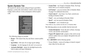
...allows you to simulate navigation. • Set Position*-sets your computer through the data card programmer. The following options: • Factory Defaults-restores all settings to Garmin's original setup values..., languages, system mode, and simulator controls, restores factory settings, shows software version, and prepares software update cards. The following settings are available: • Beeper-Off, Alarms Only, Key and Alarm: controls...when the unit is in Simulator Mode. GPSMAP 392/398/492/498 Owner's Manual MAIN MENU > SYSTM (SYSTEM) TAB • System Mode-sets Normal ...
...allows you to simulate navigation. • Set Position*-sets your computer through the data card programmer. The following options: • Factory Defaults-restores all settings to Garmin's original setup values..., languages, system mode, and simulator controls, restores factory settings, shows software version, and prepares software update cards. The following settings are available: • Beeper-Off, Alarms Only, Key and Alarm: controls...when the unit is in Simulator Mode. GPSMAP 392/398/492/498 Owner's Manual MAIN MENU > SYSTM (SYSTEM) TAB • System Mode-sets Normal ...
Owner's Manual
Page 75
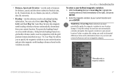
...Heading field set to User Mag Var, highlight the heading reference field (immediately to the right), and press ENTER. 2. GPSMAP 392/398/492/498 Owner's Manual Manually enter a magnetic variation. 67 Grid provides headings based on a grid north reference (and is selected, you enter....described on a true north reference. You can result in substantial differences between the information shown on the variation you must periodically update the magnetic variation as your unit and external references, such as a magnetic compass. Enter the magnetic variation at your current ...
...Heading field set to User Mag Var, highlight the heading reference field (immediately to the right), and press ENTER. 2. GPSMAP 392/398/492/498 Owner's Manual Manually enter a magnetic variation. 67 Grid provides headings based on a grid north reference (and is selected, you enter....described on a true north reference. You can result in substantial differences between the information shown on the variation you must periodically update the magnetic variation as your unit and external references, such as a magnetic compass. Enter the magnetic variation at your current ...
Owner's Manual
Page 86
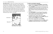
The depth is updated while the screen is resumed. Use the ROCKER to move off the paused screen and cannot show any new sonar data until the standard Sonar ... reference sonar items and mark underwater waypoints. You can see a discontinuity from your changes and press ENTER when finished. 5. Show Map Pointer Option 78 GPSMAP 392/398/492/498 Owner's Manual Make your current position. 3.
The depth is updated while the screen is resumed. Use the ROCKER to move off the paused screen and cannot show any new sonar data until the standard Sonar ... reference sonar items and mark underwater waypoints. You can see a discontinuity from your changes and press ENTER when finished. 5. Show Map Pointer Option 78 GPSMAP 392/398/492/498 Owner's Manual Make your current position. 3.
Owner's Manual
Page 94
... 70°C) Performance Receiver: Differential-ready 12 parallel channel WAAS-capable receiver Acquisition Times: Warm: Approx. 15 seconds Cold: Approx. 45 seconds AutoLocate: Approx. 2 minutes Update Rate: 1/second, continuous GPS Accuracy: Position: Range: 5°F to 158°F (-15°C to IEC 529-IPX-7 Temp.
... 70°C) Performance Receiver: Differential-ready 12 parallel channel WAAS-capable receiver Acquisition Times: Warm: Approx. 15 seconds Cold: Approx. 45 seconds AutoLocate: Approx. 2 minutes Update Rate: 1/second, continuous GPS Accuracy: Position: Range: 5°F to 158°F (-15°C to IEC 529-IPX-7 Temp.
Owner's Manual
Page 110
... Full." The oldest track log points were deleted to make space for new entries. 102 GPSMAP 392/398/492/498 Owner's Manual APPENDIX > MESSAGES Sonar Service Incompatible-(only applied to the GPSMAP 392/492) the external sonar device you have used all 4,000 waypoints available. This only... above, below, inside, or outside the specified value(s). User Card Not Found, Please Insert Card-attempted to needs a software update. Waypoint Already Exists-you entered a saved track name that already exists in the Data Card slot. Waypoint Memory Full-you are connected to...
... Full." The oldest track log points were deleted to make space for new entries. 102 GPSMAP 392/398/492/498 Owner's Manual APPENDIX > MESSAGES Sonar Service Incompatible-(only applied to the GPSMAP 392/492) the external sonar device you have used all 4,000 waypoints available. This only... above, below, inside, or outside the specified value(s). User Card Not Found, Please Insert Card-attempted to needs a software update. Waypoint Already Exists-you entered a saved track name that already exists in the Data Card slot. Waypoint Memory Full-you are connected to...

Owner's Manual
Page 118
... 97 MOB 10 N narrow beam 72 NAV/MOB Key 5, 12 navaids 63 navigating 12 distress call 24 Go To 13 position report 24 routes 18 TracBack 14 navigation terms 98 NMEA 70 north up 62 O off course alarm 71 orientation 62 Out...location 95 satellite sky view 95 scroll speed 80 selecting options 6 shallow/deep water alarm 71 simulator mode 3 software update card 65 soft bottom 84 sonar 72 depth line 76 understanding 72 whiteline 76 Sonar Page 74 adjustment menu 75 sonar... 65 T temperature 82 temperature graph 77 temperature scale 64 temperature tab 63 thermoclines 83 GPSMAP 392/398/492/498 Owner's Manual
... 97 MOB 10 N narrow beam 72 NAV/MOB Key 5, 12 navaids 63 navigating 12 distress call 24 Go To 13 position report 24 routes 18 TracBack 14 navigation terms 98 NMEA 70 north up 62 O off course alarm 71 orientation 62 Out...location 95 satellite sky view 95 scroll speed 80 selecting options 6 shallow/deep water alarm 71 simulator mode 3 software update card 65 soft bottom 84 sonar 72 depth line 76 understanding 72 whiteline 76 Sonar Page 74 adjustment menu 75 sonar... 65 T temperature 82 temperature graph 77 temperature scale 64 temperature tab 63 thermoclines 83 GPSMAP 392/398/492/498 Owner's Manual
Owner's Manual
Page 122
For the latest free software updates (excluding map data) throughout the life of your Garmin products, visit the Garmin Web site at www.garmin.com. © Copyright 2006 Garmin Ltd. C or its subsidiaries Garmin International, Inc. 1200 East 151st Street, Olathe, Kansas 66062, USA Garmin (Europe) Ltd. Unit 5, The Quadrangle, Abbey Park Industrial Estate, Romsey, SO51 9DL, UK Garmin Corporation No. 68, Jangshu 2nd Road, Shijr, Taipei County, Taiwan www.garmin.com Part Number 190-00653-00 Rev.
For the latest free software updates (excluding map data) throughout the life of your Garmin products, visit the Garmin Web site at www.garmin.com. © Copyright 2006 Garmin Ltd. C or its subsidiaries Garmin International, Inc. 1200 East 151st Street, Olathe, Kansas 66062, USA Garmin (Europe) Ltd. Unit 5, The Quadrangle, Abbey Park Industrial Estate, Romsey, SO51 9DL, UK Garmin Corporation No. 68, Jangshu 2nd Road, Shijr, Taipei County, Taiwan www.garmin.com Part Number 190-00653-00 Rev.


