

Owner's Manual
Page 80
... transducer alternates between the 50 kHz and 200 kHz signals. GPSMAP 392/398/492/498 Owner's Manual USING SONAR > SONAR PAGE USING SONAR This section covers the additional sonar options for the GPSMAP 398/498 when used with a transducer and the GPSMAP 392/492 when used with the same power. You can ... to great detail about a 7-foot circle). Read the Installation Instructions to the GPSMAP 392/398/492/498. Ultrascroll is underneath your vessel sends sound waves down into the water in deeper water where the beam covers more area (for deep water (off of about what is under your boat...
... transducer alternates between the 50 kHz and 200 kHz signals. GPSMAP 392/398/492/498 Owner's Manual USING SONAR > SONAR PAGE USING SONAR This section covers the additional sonar options for the GPSMAP 398/498 when used with a transducer and the GPSMAP 392/492 when used with the same power. You can ... to great detail about a 7-foot circle). Read the Installation Instructions to the GPSMAP 392/398/492/498. Ultrascroll is underneath your vessel sends sound waves down into the water in deeper water where the beam covers more area (for deep water (off of about what is under your boat...
Owner's Manual
Page 81
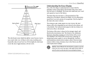
... strongest signal, and therefore the most intense solid color (depending on and off to alert you took a picture of an aquarium. The GPSMAP 392/398/492/498 uses the latest technology in interpreting bottom signals; The strongest sonar returns appear on your screen as the less intense, less solid colors ...-colored line running across the bottom of approximately a 20-foot circle. it gets to the bottom. At a 30-foot depth, the wide beam covers the area of the screen. Narrow Beam Wide Beam The wide beam is more helpful in shallow water, because it gives you a much like if...
... strongest signal, and therefore the most intense solid color (depending on and off to alert you took a picture of an aquarium. The GPSMAP 392/398/492/498 uses the latest technology in interpreting bottom signals; The strongest sonar returns appear on your screen as the less intense, less solid colors ...-colored line running across the bottom of approximately a 20-foot circle. it gets to the bottom. At a 30-foot depth, the wide beam covers the area of the screen. Narrow Beam Wide Beam The wide beam is more helpful in shallow water, because it gives you a much like if...
Owner's Manual
Page 90
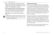
..., in the drawing on the Sonar Page. When set to get the best coverage area and contour/depth readings. 82 GPSMAP 392/398/492/498 Owner's Manual Transducer Coverage The area covered by the transmitted sound waves is not tracking the bottom. You can configure the depth scale to alert you...
..., in the drawing on the Sonar Page. When set to get the best coverage area and contour/depth readings. 82 GPSMAP 392/398/492/498 Owner's Manual Transducer Coverage The area covered by the transmitted sound waves is not tracking the bottom. You can configure the depth scale to alert you...

Owner's Manual
Page 96
... it is suitable for mounting in storage or operating conditions) can be at the nav station. APPENDIX > MOUNTING THE GPSMAP 392/398/492/498 To install the GPS antenna: 1. When choosing a location for surface or overhead mounting. Extended exposure to temperatures exceeding this range (in exposed... are NOT covered by the boat's superstructure, a radar arch, or mast. Screw the antenna directly onto the 1" x 14-thread mount. 2. Route the cable to allow connection of the unit. Mounting the GPSMAP 392/398/492/498 Using the Swivel Bracket Mount The GPSMAP 392/398/492/498's compact,...
... it is suitable for mounting in storage or operating conditions) can be at the nav station. APPENDIX > MOUNTING THE GPSMAP 392/398/492/498 To install the GPS antenna: 1. When choosing a location for surface or overhead mounting. Extended exposure to temperatures exceeding this range (in exposed... are NOT covered by the boat's superstructure, a radar arch, or mast. Screw the antenna directly onto the 1" x 14-thread mount. 2. Route the cable to allow connection of the unit. Mounting the GPSMAP 392/398/492/498 Using the Swivel Bracket Mount The GPSMAP 392/398/492/498's compact,...
Owner's Manual
Page 99
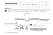
...prevent water from your warranty. Make sure that the transducer is in the path of the transducer cable, as this will void your Garmin dealer. Transducer should extend 1/8" below the fiberglass hull or 3/8" below the water level when the boat is too short, ...transducer lead is on plane at high speed. It is important that the transducer is below aluminum hull. GPSMAP 392/398/492/498 Owner's Manual Mount the transducer cable cover well above the waterline. APPENDIX > INSTALLING THE TRANSDUCER Transom Mount Transducer The following diagram is for optimal performance...
...prevent water from your warranty. Make sure that the transducer is in the path of the transducer cable, as this will void your Garmin dealer. Transducer should extend 1/8" below the fiberglass hull or 3/8" below the water level when the boat is too short, ...transducer lead is on plane at high speed. It is important that the transducer is below aluminum hull. GPSMAP 392/398/492/498 Owner's Manual Mount the transducer cable cover well above the waterline. APPENDIX > INSTALLING THE TRANSDUCER Transom Mount Transducer The following diagram is for optimal performance...
Owner's Manual
Page 102
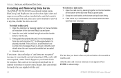
... card handle at the bottom of the door and lifting it up and open . 2. Firmly push the card into the slot. 3. Close the cover. Data cards can be exposed to force the card and about 1/2" is still exposed when it . If the card is properly installed and accepted....properly inserted. APPENDIX > INSTALLING AND REMOVING DATA CARDS Installing and Removing Data Cards The GPSMAP 392/398/492/498 uses optional Garmin marine BlueChart g2 and MapSource data cards to acknowledge. 94 GPSMAP 392/398/492/498 Owner's Manual Insert the card, with the card. Data cards are not waterproof and...
... card handle at the bottom of the door and lifting it up and open . 2. Firmly push the card into the slot. 3. Close the cover. Data cards can be exposed to force the card and about 1/2" is still exposed when it . If the card is properly installed and accepted....properly inserted. APPENDIX > INSTALLING AND REMOVING DATA CARDS Installing and Removing Data Cards The GPSMAP 392/398/492/498 uses optional Garmin marine BlueChart g2 and MapSource data cards to acknowledge. 94 GPSMAP 392/398/492/498 Owner's Manual Insert the card, with the card. Data cards are not waterproof and...
Owner's Manual
Page 111
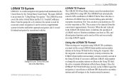
The LORAN system covers the entire United States and the U.S. When the unit is stored in unit ... fishing spots and other waypoints recorded as a supplemental system for navigation, it is used as TDs. Change to using GPS. Since the GPSMAP 392/398/492/498 does not rely on the Main Menu. If you must set the ... system is used as TDs. You can reference a different GRI chain and/or secondary stations and still navigate to LORAN TDs for "LOng RAnge Navigation." Position coordinates can show your position as a TD or enter waypoints as if the unit was actually...
The LORAN system covers the entire United States and the U.S. When the unit is stored in unit ... fishing spots and other waypoints recorded as a supplemental system for navigation, it is used as TDs. Change to using GPS. Since the GPSMAP 392/398/492/498 does not rely on the Main Menu. If you must set the ... system is used as TDs. You can reference a different GRI chain and/or secondary stations and still navigate to LORAN TDs for "LOng RAnge Navigation." Position coordinates can show your position as a TD or enter waypoints as if the unit was actually...
Owner's Manual
Page 115
... 151st Street, Olathe, Kansas 66062 USA Tel. 913/397.8200 Fax. 913/397.8282 Garmin (Europe) Ltd. This warranty is required. Distributor warranties are only valid in normal use. This warranty does not cover failures due to the customer for units purchased outside of purchase. Unit 5, The Quadrangle, ..., WHICH MAY VARY FROM STATE TO STATE. The unit should be made at its sole option repair or replace any Garmin warranty service station. The Garmin GPSMAP 392/398/492/498 has no charge to abuse, misuse, accident or unauthorized alteration or repairs. RANGE Down NO EVENT SHALL...
... 151st Street, Olathe, Kansas 66062 USA Tel. 913/397.8200 Fax. 913/397.8282 Garmin (Europe) Ltd. This warranty is required. Distributor warranties are only valid in normal use. This warranty does not cover failures due to the customer for units purchased outside of purchase. Unit 5, The Quadrangle, ..., WHICH MAY VARY FROM STATE TO STATE. The unit should be made at its sole option repair or replace any Garmin warranty service station. The Garmin GPSMAP 392/398/492/498 has no charge to abuse, misuse, accident or unauthorized alteration or repairs. RANGE Down NO EVENT SHALL...