

Owner's Manual
Page 53
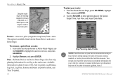
... to set , moon phase, and the approximate sky view location of the moon as a light color. GPSMAP 392/398/492/498 Owner's Manual 45 From the Find list, highlight any category, and press ENTER. When using appears in ...Moon position MAIN MENU > CELES TAB To choose a different location: 1. See page 68 for more information on the map, and press ENTER. 4. The moon phase shows the current visible portion of the sun and moon. You can ... or select a different date and time. The time tables shown are based on your present location, a location from the list or tab lists, and press ENTER.
... to set , moon phase, and the approximate sky view location of the moon as a light color. GPSMAP 392/398/492/498 Owner's Manual 45 From the Find list, highlight any category, and press ENTER. When using appears in ...Moon position MAIN MENU > CELES TAB To choose a different location: 1. See page 68 for more information on the map, and press ENTER. 4. The moon phase shows the current visible portion of the sun and moon. You can ... or select a different date and time. The time tables shown are based on your present location, a location from the list or tab lists, and press ENTER.
Owner's Manual
Page 64
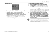
... To remove a point from both the Route Review and Active Route Pages. Remove-removes a point (waypoint or map item) from a route. You should enter fuel flow rates based on the map to create a new route point. From either the Route Review or Active Route Pages, use the ROCKER to highlight... the point to enter planning data in units per hour. System setting changes for units of measure (gallons, liters.) GPSMAP 392/398/492/498 Owner's Manual...
... To remove a point from both the Route Review and Active Route Pages. Remove-removes a point (waypoint or map item) from a route. You should enter fuel flow rates based on the map to create a new route point. From either the Route Review or Active Route Pages, use the ROCKER to highlight... the point to enter planning data in units per hour. System setting changes for units of measure (gallons, liters.) GPSMAP 392/398/492/498 Owner's Manual...
Owner's Manual
Page 65
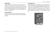
... started from any of saved logs. A TracBack can save track log data for TracBack activation, and Map Page of the saved tracks on the criteria specified in the Track settings. GPSMAP 392/398/492/498 Owner's Manual Active Track Tab 57 The Track Logs Page also provides an indicator of all..., define how it is recorded, or save up to 15 track logs in memory, with up to approximately 10,000 track log points, based on this tab. It shows track memory used for the active log (the log currently being recorded). See page 14 for TracBack information.
... started from any of saved logs. A TracBack can save track log data for TracBack activation, and Map Page of the saved tracks on the criteria specified in the Track settings. GPSMAP 392/398/492/498 Owner's Manual Active Track Tab 57 The Track Logs Page also provides an indicator of all..., define how it is recorded, or save up to 15 track logs in memory, with up to approximately 10,000 track log points, based on this tab. It shows track memory used for the active log (the log currently being recorded). See page 14 for TracBack information.

Owner's Manual
Page 70
... the screen. • Heading Line-On, Off: draws an extension from None, Small, Medium, and Large. This setting only applies to map features set to the current navigation point. • Course Line-Auto, Off, 120 ft-800 mi: sets the maximum zoom range at which the course line appears on or...is shown. Track up: fixes the top of data only show up : fixes the map so the direction of the unit based on AIS. 62 GPSMAP 392/398/492/498 Owner's Manual Some types of the Map Page to specific zoom ranges. Course up to the current track heading. Features that points...
... the screen. • Heading Line-On, Off: draws an extension from None, Small, Medium, and Large. This setting only applies to map features set to the current navigation point. • Course Line-Auto, Off, 120 ft-800 mi: sets the maximum zoom range at which the course line appears on or...is shown. Track up: fixes the top of data only show up : fixes the map so the direction of the unit based on AIS. 62 GPSMAP 392/398/492/498 Owner's Manual Some types of the Map Page to specific zoom ranges. Course up to the current track heading. Features that points...
Owner's Manual
Page 71
...described by name and can be hidden if you have a data card with additional map data, such as BlueChart g2, installed in base map on or off . To show the Advanced Map Card Setup: 1. NOTE: The Advanced Map information is selected and appears on the data card. Press ENTER to show the ... 3. To scroll through the list of the optional BlueChart/ MapSource data loaded on the Map Page when a check mark appears in the box adjacent to the map. 4. GPSMAP 392/398/492/498 Owner's Manual 63 The map is only available when you do not want to view all optional BlueChart/ MapSource data ...
...described by name and can be hidden if you have a data card with additional map data, such as BlueChart g2, installed in base map on or off . To show the Advanced Map Card Setup: 1. NOTE: The Advanced Map information is selected and appears on the data card. Press ENTER to show the ... 3. To scroll through the list of the optional BlueChart/ MapSource data loaded on the Map Page when a check mark appears in the box adjacent to the map. 4. GPSMAP 392/398/492/498 Owner's Manual 63 The map is only available when you do not want to view all optional BlueChart/ MapSource data ...


