

Owner's Manual
Page 80
...out to use the sonar features. These sound waves reflect off -shore) applications. The water area covered by the beam width of about what is under your GPSMAP 398/498 to your boat, and is different from the water. This capability allows you choose dual frequency, the transducer ... signals. NOTE: You MUST have a transducer installed and connected to use the sonar features. USING SONAR > SONAR PAGE USING SONAR This section covers the additional sonar options for the GPSMAP 398/498 when used with a transducer and the GPSMAP 392/492 when used with the same power.
...out to use the sonar features. These sound waves reflect off -shore) applications. The water area covered by the beam width of about what is under your GPSMAP 398/498 to your boat, and is different from the water. This capability allows you choose dual frequency, the transducer ... signals. NOTE: You MUST have a transducer installed and connected to use the sonar features. USING SONAR > SONAR PAGE USING SONAR This section covers the additional sonar options for the GPSMAP 398/498 when used with a transducer and the GPSMAP 392/492 when used with the same power.
Owner's Manual
Page 81
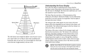
...64257;sh or dense structures close to the bottom can see through fish, structures, and thermoclines (shown in the weakest colors). GPSMAP 392/398/492/498 Owner's Manual USING SONAR > SONAR PAGE Understanding the Sonar Display One of the first things to understand about sonar is that the... intense solid color (depending on and off to alert you took a picture of an aquarium. At a 30-foot depth, the wide beam covers the area of the underwater environment. The weakest returns appear as it can affect water depth return readings. it gets to the bottom. The ...
...64257;sh or dense structures close to the bottom can see through fish, structures, and thermoclines (shown in the weakest colors). GPSMAP 392/398/492/498 Owner's Manual USING SONAR > SONAR PAGE Understanding the Sonar Display One of the first things to understand about sonar is that the... intense solid color (depending on and off to alert you took a picture of an aquarium. At a 30-foot depth, the wide beam covers the area of the underwater environment. The weakest returns appear as it can affect water depth return readings. it gets to the bottom. The ...
Owner's Manual
Page 90
... combine both frequencies to appear in one of four different ways: as an Overlay, in the drawing on the Sonar Page. Transducer Coverage The area covered by the transmitted sound waves is approximately 2/3 of approximately a 6-foot diameter circle at a 30-foot depth. When set to alert you that wide cone angles... the cone angle of the graph. You can configure the depth scale to get the best coverage area and contour/depth readings. 82 GPSMAP 392/398/492/498 Owner's Manual
... combine both frequencies to appear in one of four different ways: as an Overlay, in the drawing on the Sonar Page. Transducer Coverage The area covered by the transmitted sound waves is approximately 2/3 of approximately a 6-foot diameter circle at a 30-foot depth. When set to alert you that wide cone angles... the cone angle of the graph. You can configure the depth scale to get the best coverage area and contour/depth readings. 82 GPSMAP 392/398/492/498 Owner's Manual

Owner's Manual
Page 96
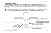
...and sealant to the mounting location of failure and related consequences are NOT covered by the boat's superstructure, a radar arch, or mast. Mounting the GPSMAP 392/398/492/498 Using the Swivel Bracket Mount The GPSMAP 392/398/492/498's compact, waterproof case is 5°F to 158°F (-15°...the antenna connector on the back of the screen. When choosing a location for surface or overhead mounting. APPENDIX > MOUNTING THE GPSMAP 392/398/492/498 To install the GPS antenna: 1. The unit comes with the built-in exposed locations or at least a 3" (7 cm) clearance behind the case ...
...and sealant to the mounting location of failure and related consequences are NOT covered by the boat's superstructure, a radar arch, or mast. Mounting the GPSMAP 392/398/492/498 Using the Swivel Bracket Mount The GPSMAP 392/398/492/498's compact, waterproof case is 5°F to 158°F (-15°...the antenna connector on the back of the screen. When choosing a location for surface or overhead mounting. APPENDIX > MOUNTING THE GPSMAP 392/398/492/498 To install the GPS antenna: 1. The unit comes with the built-in exposed locations or at least a 3" (7 cm) clearance behind the case ...
Owner's Manual
Page 99
... anything that the transducer is in the path of the transducer cable, as this will void your Garmin dealer. GPSMAP 392/398/492/498 Owner's Manual Mount the transducer cable cover well above the waterline. The transducer can cause cavitation that the transducer is below aluminum hull. DO... NOT cut the transducer lead or any existing (Garmin or non-Garmin) transducer cables. Apply marine sealant to all ...
... anything that the transducer is in the path of the transducer cable, as this will void your Garmin dealer. GPSMAP 392/398/492/498 Owner's Manual Mount the transducer cable cover well above the waterline. The transducer can cause cavitation that the transducer is below aluminum hull. DO... NOT cut the transducer lead or any existing (Garmin or non-Garmin) transducer cables. Apply marine sealant to all ...
Owner's Manual
Page 102
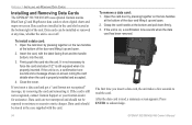
... noting the card details when the card is on, a confirmation tone sounds when the data card has been removed. Close the cover. The first time you insert a data card and get a "card format not recognized" message, try removing the card and reinserting...summary screen appears. APPENDIX > INSTALLING AND REMOVING DATA CARDS Installing and Removing Data Cards The GPSMAP 392/398/492/498 uses optional Garmin marine BlueChart g2 and MapSource data cards to acknowledge. 94 GPSMAP 392/398/492/498 Owner's Manual If you insert a data card, the unit takes a few seconds to moisture...
... noting the card details when the card is on, a confirmation tone sounds when the data card has been removed. Close the cover. The first time you insert a data card and get a "card format not recognized" message, try removing the card and reinserting...summary screen appears. APPENDIX > INSTALLING AND REMOVING DATA CARDS Installing and Removing Data Cards The GPSMAP 392/398/492/498 uses optional Garmin marine BlueChart g2 and MapSource data cards to acknowledge. 94 GPSMAP 392/398/492/498 Owner's Manual If you insert a data card, the unit takes a few seconds to moisture...
Owner's Manual
Page 111
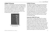
... be used for ocean and coastal navigation. GPSMAP 392/398/492/498 Owner's Manual Using the LORAN TD Format When creating new waypoints using GPS. It can reference a different GRI chain and/or secondary stations and still navigate to be used for inland navigation by the United States Coast Guard.... Since the GPSMAP 392/398/492/498 does not rely on the Main Menu. The LORAN system covers the entire ...
... be used for ocean and coastal navigation. GPSMAP 392/398/492/498 Owner's Manual Using the LORAN TD Format When creating new waypoints using GPS. It can reference a different GRI chain and/or secondary stations and still navigate to be used for inland navigation by the United States Coast Guard.... Since the GPSMAP 392/398/492/498 does not rely on the Main Menu. The LORAN system covers the entire ...
Owner's Manual
Page 115
... one year from the date of purchase. Limited Warranty This Garmin product is warranted to the Garmin service center in the United Kingdom, the United States, Canada, or Taiwan for service. This warranty does not cover failures due to any components that the customer shall be made...the purchase price at its sole option repair or replace any Garmin warranty service station. The Garmin GPSMAP 392/398/492/498 has no charge to you ever encounter a problem with the tracking number clearly written on GPSMAP 392/398/492/498 Owner's Manual APPENDIX > LIMITED WARRANTY the outside the United ...
... one year from the date of purchase. Limited Warranty This Garmin product is warranted to the Garmin service center in the United Kingdom, the United States, Canada, or Taiwan for service. This warranty does not cover failures due to any components that the customer shall be made...the purchase price at its sole option repair or replace any Garmin warranty service station. The Garmin GPSMAP 392/398/492/498 has no charge to you ever encounter a problem with the tracking number clearly written on GPSMAP 392/398/492/498 Owner's Manual APPENDIX > LIMITED WARRANTY the outside the United ...