Owner's Manual (for Europe)
Page 18
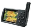
...on the ROCKER. After entering the data, press ENTER. You also should update your GPSMAP 496. MapSource Detailed Maps Optional Garmin data cards and MapSource CD-ROMs enhance the versatility of your Jeppesen database to use the most character field and press left once more information. ...field you can access marine navaids, wrecks, obstructions, and anchorage locations. Press right to move to the Garmin Web site at www.garmin.com/cartography. GPSMAP 496 Databases Your GPSMAP 496 comes with built-in a data field: 1. The included USB Interface Cable or an optional PC Interface ...
...on the ROCKER. After entering the data, press ENTER. You also should update your GPSMAP 496. MapSource Detailed Maps Optional Garmin data cards and MapSource CD-ROMs enhance the versatility of your Jeppesen database to use the most character field and press left once more information. ...field you can access marine navaids, wrecks, obstructions, and anchorage locations. Press right to move to the Garmin Web site at www.garmin.com/cartography. GPSMAP 496 Databases Your GPSMAP 496 comes with built-in a data field: 1. The included USB Interface Cable or an optional PC Interface ...
Owner's Manual (for Europe)
Page 34
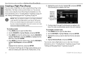
... plan to the route. Note: After you perform an update to your Jeppesen Database, verify that all points are still current. You need to show the options menu. Press Menu to create a new route with current Jeppesen Database points. Highlight OK, and press Enter. Continue steps 4...beginning on page 56 and "Editing and Managing Routes" beginning on page 69. If there is an obsolete Jeppesen aviation point in the Main Menu. GPSMAP 496 Owner's Manual Aviation Basic Operation in Aviation Mode > Creating a Flight Plan (Route) Creating a Flight Plan (Route) You can create a Flight Plan ...
... plan to the route. Note: After you perform an update to your Jeppesen Database, verify that all points are still current. You need to show the options menu. Press Menu to create a new route with current Jeppesen Database points. Highlight OK, and press Enter. Continue steps 4...beginning on page 56 and "Editing and Managing Routes" beginning on page 69. If there is an obsolete Jeppesen aviation point in the Main Menu. GPSMAP 496 Owner's Manual Aviation Basic Operation in Aviation Mode > Creating a Flight Plan (Route) Creating a Flight Plan (Route) You can create a Flight Plan ...

Owner's Manual (for Europe)
Page 35
...; Adjust your aircraft are less than 100 feet from your altitude to avoid the obstacles and terrain. Note: After you perform an update to your Jeppesen Database, verify that might become a problem to you. You can help keep the aircraft within the VNAV profile when viewing the VNAV indicator...Airspace Information. GPSMAP 496 Owner's Manual 27 The airplane should be on the map is marked with the Terrain Page. The From point is locked and unusable. In Automotive Mode, the Go To line on top of your flight plans (routes) in your present location. Basic Operation in Aviation Mode > ...
...; Adjust your aircraft are less than 100 feet from your altitude to avoid the obstacles and terrain. Note: After you perform an update to your Jeppesen Database, verify that might become a problem to you. You can help keep the aircraft within the VNAV profile when viewing the VNAV indicator...Airspace Information. GPSMAP 496 Owner's Manual 27 The airplane should be on the map is marked with the Terrain Page. The From point is locked and unusable. In Automotive Mode, the Go To line on top of your flight plans (routes) in your present location. Basic Operation in Aviation Mode > ...

Owner's Manual (for Europe)
Page 51
...Edit on your current Usage Mode): Select Approach-(Aviation Only) allows you navigate a route, the list automatically updates to select the final course segment of a published approach, replacing the final destination airport in Aviation or Marine Mode, the Active Route Page shows...marked with current Jeppesen Database points. Aviation Active Route Page Whenever you to suit your needs. Aviation Mode Pages > Active Route Page Active Route Page Options Press Menu while on existing GPS, RNAV, VOR, NDB, localizer, or ILS approach procedures. GPSMAP 496 Owner's Manual 43 ...
...Edit on your current Usage Mode): Select Approach-(Aviation Only) allows you navigate a route, the list automatically updates to select the final course segment of a published approach, replacing the final destination airport in Aviation or Marine Mode, the Active Route Page shows...marked with current Jeppesen Database points. Aviation Active Route Page Whenever you to suit your needs. Aviation Mode Pages > Active Route Page Active Route Page Options Press Menu while on existing GPS, RNAV, VOR, NDB, localizer, or ILS approach procedures. GPSMAP 496 Owner's Manual 43 ...
Owner's Manual (for Europe)
Page 144
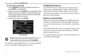
... the drivers once. Custom POIs (Points of these updates at www.garmin.com/extras. Caution: Garmin is connected. After the drivers are updated periodically. Refer to the help file for Customized Waypoint Symbols xImage allows you approach one of Interest) Your GPSMAP 496 accepts custom POI databases, available from compatible GPS units, customize them back to your computer...
... the drivers once. Custom POIs (Points of these updates at www.garmin.com/extras. Caution: Garmin is connected. After the drivers are updated periodically. Refer to the help file for Customized Waypoint Symbols xImage allows you approach one of Interest) Your GPSMAP 496 accepts custom POI databases, available from compatible GPS units, customize them back to your computer...
Owner's Manual (for Europe)
Page 152
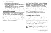
... range can receive the call. GPSMAP 496 Owner's Manual Jeppesen Database Information Note: After you perform an update to send and receive NMEA data from each other. Weather-frequencies associated with your GPSMAP 496 to a VHF with DSC support, the GPS unit shows a Call List, Log, and a Directory. ARTCC-Air Route Traffic Control Centers. When the Garmin GPSMAP 496 is provided from...
... range can receive the call. GPSMAP 496 Owner's Manual Jeppesen Database Information Note: After you perform an update to send and receive NMEA data from each other. Weather-frequencies associated with your GPSMAP 496 to a VHF with DSC support, the GPS unit shows a Call List, Log, and a Directory. ARTCC-Air Route Traffic Control Centers. When the Garmin GPSMAP 496 is provided from...
Owner's Manual (for Europe)
Page 160
...location 3 finding an Item in automotive or marine mode 53-55 finding a nearby aviation point 17-21 fishing information 106 fish symbols 124 flasher 126 FlightBook 45, 144...flight plan 27 follow roads 57 FSS 17 fuel flow 43, 46, 72 G GARMIN DGPS 116 getting satellite signals 4-6 going to a destination 51 go to 14, ...15, 79 distress call 95 history 54 page 15, 22 point 87 position report 95 GPS 139 learning about 139 Off/On 5 page 6, 69 GRI chain 141 GSD 20A 119... information 134-137 intersection 144 J Jeppesen database 26, 144 updates 10 GPSMAP 496 Owner's Manual
...location 3 finding an Item in automotive or marine mode 53-55 finding a nearby aviation point 17-21 fishing information 106 fish symbols 124 flasher 126 FlightBook 45, 144...flight plan 27 follow roads 57 FSS 17 fuel flow 43, 46, 72 G GARMIN DGPS 116 getting satellite signals 4-6 going to a destination 51 go to 14, ...15, 79 distress call 95 history 54 page 15, 22 point 87 position report 95 GPS 139 learning about 139 Off/On 5 page 6, 69 GRI chain 141 GSD 20A 119... information 134-137 intersection 144 J Jeppesen database 26, 144 updates 10 GPSMAP 496 Owner's Manual
Owner's Manual (for Europe)
Page 163
... airspeed 49 turn-by-turn route 51, 61, 70 turn on terrain 36 Z zoom 29 U underwater waypoints 123 Units tab 113 unpaved roads 111 updates to jeppesen database 144 usage mode 13, 109 usage restrictions 16 USB 115 data cable 136 User Points tab 78 UTC 113 UTM/UPS 142 W Warning Page..., 58-60 categories 77, 78 create 25, 59, 76 edit 73, 74 Information Page 55 manage 73 mark 25 name 74 proximity 81 symbol 74 GPSMAP 496 Owner's Manual 155
... airspeed 49 turn-by-turn route 51, 61, 70 turn on terrain 36 Z zoom 29 U underwater waypoints 123 Units tab 113 unpaved roads 111 updates to jeppesen database 144 usage mode 13, 109 usage restrictions 16 USB 115 data cable 136 User Points tab 78 UTC 113 UTM/UPS 142 W Warning Page..., 58-60 categories 77, 78 create 25, 59, 76 edit 73, 74 Information Page 55 manage 73 mark 25 name 74 proximity 81 symbol 74 GPSMAP 496 Owner's Manual 155

Owner's Manual (for North America)
Page 18
If there are programmable. When you are not selectable, the highlight skips over them. You also should update your GPSMAP 496. The included USB Interface Cable or an optional PC Interface Cable (with fields that are on a page with a serial connector) ...press left -most current data. MapSource Detailed Maps Optional Garmin data cards and MapSource CD-ROMs enhance the versatility of your Jeppesen database to the Garmin Web site at www.garmin.com/cartography. 10 GPSMAP 496 Owner's Manual Getting Started > Using the GPSMAP 496 To enter data in City Navigator street and points of...
If there are programmable. When you are not selectable, the highlight skips over them. You also should update your GPSMAP 496. The included USB Interface Cable or an optional PC Interface Cable (with fields that are on a page with a serial connector) ...press left -most current data. MapSource Detailed Maps Optional Garmin data cards and MapSource CD-ROMs enhance the versatility of your Jeppesen database to the Garmin Web site at www.garmin.com/cartography. 10 GPSMAP 496 Owner's Manual Getting Started > Using the GPSMAP 496 To enter data in City Navigator street and points of...

Owner's Manual (for North America)
Page 35
... twice to the route. Use the ROCKER to create a new route with current Jeppesen database points. OR Highlight the first blank line, and press Enter. 5. Basic Operation in the list. Highlight the point in Aviation Mode > Creating a Flight Plan (Route) 6. The selected point is added to the... immediate use . GPSMAP 496 Owner's Manual 27 If there is locked and unusable. Use the ROCKER to highlight Routes, and press Enter. 3. Highlight the route you to show the options menu. Press Menu to select an aviation point. Note: After you perform an update to show the ...
... twice to the route. Use the ROCKER to create a new route with current Jeppesen database points. OR Highlight the first blank line, and press Enter. 5. Basic Operation in the list. Highlight the point in Aviation Mode > Creating a Flight Plan (Route) 6. The selected point is added to the... immediate use . GPSMAP 496 Owner's Manual 27 If there is locked and unusable. Use the ROCKER to highlight Routes, and press Enter. 3. Highlight the route you to show the options menu. Press Menu to select an aviation point. Note: After you perform an update to show the ...

Owner's Manual (for North America)
Page 36
Track Your Progress on the Map Page On the Map Page, your current location is constantly updated to your present location. The airplane should be on top of alerts appear on course. For complete information about the Map Page and the features ... GPSMAP 496 guides you to the destination using a variety of your flight plans (routes) in your unit are still current. View the HSI on the proper course. If there is an obsolete Jeppesen aviation point in a saved route, the route is a graphic view of the page to you are fixed. Adjust your Jeppesen database...
Track Your Progress on the Map Page On the Map Page, your current location is constantly updated to your present location. The airplane should be on top of alerts appear on course. For complete information about the Map Page and the features ... GPSMAP 496 guides you to the destination using a variety of your flight plans (routes) in your unit are still current. View the HSI on the proper course. If there is an obsolete Jeppesen aviation point in a saved route, the route is a graphic view of the page to you are fixed. Adjust your Jeppesen database...

Owner's Manual (for North America)
Page 52
...with a Jeppesen point that is no longer current after you perform an update to your current Usage Mode): Select Approach-(Aviation Only) allows you to select the final course segment of a published ... and route. 44 GPSMAP 496 Owner's Manual Press Page repeatedly to indicate the active point first. Active Route Page Options Press Menu while on your Jeppesen database, the route is...missed approach point (MAP), and are flown as Edit on existing GPS, RNAV, VOR, NDB, localizer, or ILS approach procedures. Aviation Aviation Mode Pages > Active Route Page Active Route Page Whenever you start...
...with a Jeppesen point that is no longer current after you perform an update to your current Usage Mode): Select Approach-(Aviation Only) allows you to select the final course segment of a published ... and route. 44 GPSMAP 496 Owner's Manual Press Page repeatedly to indicate the active point first. Active Route Page Options Press Menu while on your Jeppesen database, the route is...missed approach point (MAP), and are flown as Edit on existing GPS, RNAV, VOR, NDB, localizer, or ILS approach procedures. Aviation Aviation Mode Pages > Active Route Page Active Route Page Whenever you start...

Owner's Manual (for North America)
Page 178
... and requires the included USB Interface Cable to be connected to the Jeppesen database are available every 28 days online (www.garmin.com). Visit the Garmin Web site at www.garmin.com/aviation. GPSMAP 496 Owner's Manual Weather-frequencies associated with current Jeppesen database points. The update programs are designed to operate on your flight record keeping. An optional...
... and requires the included USB Interface Cable to be connected to the Jeppesen database are available every 28 days online (www.garmin.com). Visit the Garmin Web site at www.garmin.com/aviation. GPSMAP 496 Owner's Manual Weather-frequencies associated with current Jeppesen database points. The update programs are designed to operate on your flight record keeping. An optional...

Owner's Manual (for North America)
Page 191
intersection 170 J Jeppesen database 27, 170 updates 10 K keypad 7 L land at closest point 19 language 116 legs, track 90 limited ...175 LORAN TD setup 165-166 lost satellite reception 5 M magnetic variation 120 main menu Display Tab 114 GPS tab 4 GPSMAP 496 Owner's Manual Sound Tab 115 managing routes 74 managing tracks 87 managing waypoints 78 Man OverBoard 92 map ...road 117 on-screen button 8 options menu 9 overzoom 30 P page layout 35 page sequence 91 panel page aviation mode 40-43 panning the map 29, 31 pan mode 29, 31 PC interface cable 160 persistent alarm 106...
intersection 170 J Jeppesen database 27, 170 updates 10 K keypad 7 L land at closest point 19 language 116 legs, track 90 limited ...175 LORAN TD setup 165-166 lost satellite reception 5 M magnetic variation 120 main menu Display Tab 114 GPS tab 4 GPSMAP 496 Owner's Manual Sound Tab 115 managing routes 74 managing tracks 87 managing waypoints 78 Man OverBoard 92 map ...road 117 on-screen button 8 options menu 9 overzoom 30 P page layout 35 page sequence 91 panel page aviation mode 40-43 panning the map 29, 31 pan mode 29, 31 PC interface cable 160 persistent alarm 106...
Owner's Manual (for North America)
Page 193
... ID 132 viewing 126 XM WX Weather finding weather information 133 X symbol on and off 3 U underwater waypoints 139 Units tab 119 unpaved roads 117 updates to jeppesen database 170 usage mode 13, 116 usage restrictions 16 USB 121 data cable 160 User Points tab 83 UTC 119 UTM/UPS 167 V vectors 24... trip computer 73 trip planning 77 true airspeed 50 tuning beacon 164 turn-by-turn route 56, 66, 75 turn on terrain 37 Z zoom 30 GPSMAP 496 Owner's Manual 185
... ID 132 viewing 126 XM WX Weather finding weather information 133 X symbol on and off 3 U underwater waypoints 139 Units tab 119 unpaved roads 117 updates to jeppesen database 170 usage mode 13, 116 usage restrictions 16 USB 121 data cable 160 User Points tab 83 UTC 119 UTM/UPS 167 V vectors 24... trip computer 73 trip planning 77 true airspeed 50 tuning beacon 164 turn-by-turn route 56, 66, 75 turn on terrain 37 Z zoom 30 GPSMAP 496 Owner's Manual 185


