
Owner's Manual
Page 5
...to visually check your precise location. Making such comparisons on a routine basis will help ensure that is available to us at : www.garmin.com. iii This is particularly true outside the United States, where complete and accurate digital data is available to you are heading to some...most complete and accurate cartography that you from our web site at a reasonable cost. Map Data One of the goals of Garmin is to provide customers with a GPS receiver to determine their location on the earth within 100 meters. We use a combination of governmental and private data sources, which...
...to visually check your precise location. Making such comparisons on a routine basis will help ensure that is available to us at : www.garmin.com. iii This is particularly true outside the United States, where complete and accurate digital data is available to you are heading to some...most complete and accurate cartography that you from our web site at a reasonable cost. Map Data One of the goals of Garmin is to provide customers with a GPS receiver to determine their location on the earth within 100 meters. We use a combination of governmental and private data sources, which...
Owner's Manual
Page 7
... user is encouraged to try to correct the interference by an authorized Garmin service center. This equipment generates, uses, and can be made by one or more stringent than "outdoor" requirements. Introduction FCC Compliance The GPS V does not contain any interference received, including interference that interference will not occur in a residential installation, and...
... user is encouraged to try to correct the interference by an authorized Garmin service center. This equipment generates, uses, and can be made by one or more stringent than "outdoor" requirements. Introduction FCC Compliance The GPS V does not contain any interference received, including interference that interference will not occur in a residential installation, and...

Owner's Manual
Page 9
... Warranty vi Table Of Contents vii Reference 1 Unit Description 1 Keypad Usage 2 Features/Data Entry 3 Battery Installation 4 Turning the GPS V On/Off 5 Adjusting Screen Contrast and Backlighting 6 Unit Pages at a Glance 7 Satellite Status Page 8 Receiver Status 9 Satellite Status Page Options 10 The Map Page 12 Zooming, Panning, and Pointing 13 Navigation Information 15...
... Warranty vi Table Of Contents vii Reference 1 Unit Description 1 Keypad Usage 2 Features/Data Entry 3 Battery Installation 4 Turning the GPS V On/Off 5 Adjusting Screen Contrast and Backlighting 6 Unit Pages at a Glance 7 Satellite Status Page 8 Receiver Status 9 Satellite Status Page Options 10 The Map Page 12 Zooming, Panning, and Pointing 13 Navigation Information 15...

Owner's Manual
Page 18
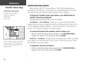
...is ready to use. Individual satellites are identified by number and correspond to the GPS receiver, whether or not they are being received. The sky view depicts an overhead view showing where the GPS V is part of what satellites are identified by number, from each satellite, ... in the sky for each satellite being used for Navigation) Satellite Number and Signal Strength The signal strength bars give you how well the GPS receiver is first turned on (after the welcome screens and warning pages). The taller the bar, the stronger the signal. The inner circle...
...is ready to use. Individual satellites are identified by number and correspond to the GPS receiver, whether or not they are being received. The sky view depicts an overhead view showing where the GPS V is part of what satellites are identified by number, from each satellite, ... in the sky for each satellite being used for Navigation) Satellite Number and Signal Strength The signal strength bars give you how well the GPS receiver is first turned on (after the welcome screens and warning pages). The taller the bar, the stronger the signal. The inner circle...

Owner's Manual
Page 19
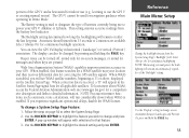
This process can take up to five minutes, depending on to reset the unit. Receiver Status Receiver Status is initializing and collecting new almanac data. Locating Satellites-the GPS V is indicated at the top of the Satellite Status Page, directly above the sky ...the satellites currently in view. "2D Differential" will appear when you are receiving differential corrections in latitude, longitude and altitude. This indicates the GPS V is looking for satellites. "Simulating GPS" means the GPS V is collecting data from available satellites, but has not collected enough ...
This process can take up to five minutes, depending on to reset the unit. Receiver Status Receiver Status is initializing and collecting new almanac data. Locating Satellites-the GPS V is indicated at the top of the Satellite Status Page, directly above the sky ...the satellites currently in view. "2D Differential" will appear when you are receiving differential corrections in latitude, longitude and altitude. This indicates the GPS V is looking for satellites. "Simulating GPS" means the GPS V is collecting data from available satellites, but has not collected enough ...
Owner's Manual
Page 20
... Status Page displayed). To change the sky view orientation: 1. Each of the main pages has an options menu, allowing you to activate the GPS V's built-in simulator mode and practice using the unit indoors. The following Satellite Status Page options are menu driven. Track Up (or North ...Use Outdoors' will appear as an option instead. If 'Use Indoors' is selected, 'North Up' will appear as an option instead. This shuts the GPS receiver off so it is not looking for satellites and helps to highlight 'Use Indoors' (or 'Use Outdoors') and press ENTER. With the Satellite Status ...
... Status Page displayed). To change the sky view orientation: 1. Each of the main pages has an options menu, allowing you to activate the GPS V's built-in simulator mode and practice using the unit indoors. The following Satellite Status Page options are menu driven. Track Up (or North ...Use Outdoors' will appear as an option instead. If 'Use Indoors' is selected, 'North Up' will appear as an option instead. This shuts the GPS receiver off so it is not looking for satellites and helps to highlight 'Use Indoors' (or 'Use Outdoors') and press ENTER. With the Satellite Status ...

Owner's Manual
Page 21
...up window appears listing two options: 'Automatic' and 'Use Map'. 2. 'Automatic' causes the GPS V to search for the right satellites and will enable the receiver to more miles since you last used the GPS V, and ensures that it is off by several hundred feet (or more), manually entering your...your approximate position. This option is useful if you have moved several hundred miles or more since the last time you used the GPS V, letting the GPS V know your approximate location will attempt to use the ROCKER KEYPAD to highlight 'New Location' and press ENTER. New Elevation-...
...up window appears listing two options: 'Automatic' and 'Use Map'. 2. 'Automatic' causes the GPS V to search for the right satellites and will enable the receiver to more miles since you last used the GPS V, and ensures that it is off by several hundred feet (or more), manually entering your...your approximate position. This option is useful if you have moved several hundred miles or more since the last time you used the GPS V, letting the GPS V know your approximate location will attempt to use the ROCKER KEYPAD to highlight 'New Location' and press ENTER. New Elevation-...
Owner's Manual
Page 31
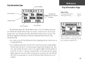
... helpful statistics about your trip. In order to accurately measure elapsed time during the trip. The following suggestions will allow the unit to continue receiving satellites, use the batteries when vehicle power is the Trip Information Page. If you are making a long trip, you with a screen prompt..., if it can use batteries and the cigarette lighter adapter for your trip. This will help you make frequent stops, leave the GPS V powered on resetting will follow. • If you obtain the maximum benefit from the Trip Information Page: • Be certain to...
... helpful statistics about your trip. In order to accurately measure elapsed time during the trip. The following suggestions will allow the unit to continue receiving satellites, use the batteries when vehicle power is the Trip Information Page. If you are making a long trip, you with a screen prompt..., if it can use batteries and the cigarette lighter adapter for your trip. This will help you make frequent stops, leave the GPS V powered on resetting will follow. • If you obtain the maximum benefit from the Trip Information Page: • Be certain to...

Owner's Manual
Page 64
...screen. Use the ROCKER KEYPAD to select from three different modes of operation: 'Normal', 'Battery Saver' or 'Demo Mode'. Demo Mode shuts off the satellite receiver Battery Saver and Demo Mode will prolong battery life. Each selectable Setup Page is labeled and identified according to its file tab... Drag, Proximity Waypoints, Proximity Alarm Format, Baud Rate, DGPS Beacon Information Main Menu: Setup: System The System Setup Page allows you to customize your GPS V to select 'Setup'. 2. Follow the steps on page 50 to your personal preferences. To select a Setup Page: 1.
...screen. Use the ROCKER KEYPAD to select from three different modes of operation: 'Normal', 'Battery Saver' or 'Demo Mode'. Demo Mode shuts off the satellite receiver Battery Saver and Demo Mode will prolong battery life. Each selectable Setup Page is labeled and identified according to its file tab... Drag, Proximity Waypoints, Proximity Alarm Format, Baud Rate, DGPS Beacon Information Main Menu: Setup: System The System Setup Page allows you to customize your GPS V to select 'Setup'. 2. Follow the steps on page 50 to your personal preferences. To select a Setup Page: 1.
Owner's Manual
Page 65
...determines how long the backlighting will appear with selections for continuous backlight operation. When correction data is received, a "D" will remain on -screen messages, or sound for correcting the GPS satellite signals. If you wish to change and press ENTER. This setting ensures accurate readings from... to change a System Setup Page feature: 1. The display can view the GPS V's Display in Demo Mode. When enabled, this feature searches for a WAAS satellite near your location and then receives differential data for messages and when keys are available. To learn more about ...
...determines how long the backlighting will appear with selections for continuous backlight operation. When correction data is received, a "D" will remain on -screen messages, or sound for correcting the GPS satellite signals. If you wish to change and press ENTER. This setting ensures accurate readings from... to change a System Setup Page feature: 1. The display can view the GPS V's Display in Demo Mode. When enabled, this feature searches for a WAAS satellite near your location and then receives differential data for messages and when keys are available. To learn more about ...

Owner's Manual
Page 73
...highlight the desired setting and press ENTER. 4. No input. RTCM In/NMEA Out-Allows DGPS input using a beacon receiver setting (Garmin DGPS or RTCM In/NMEA Out), the GPS V can select 'Manual' and enter the beacon frequency and bit rate. 63 Follow the steps on page 54... Or, you control the input/output format used with a Garmin differential beacon receiver (e.g., GBR 23). To change an Interface Setup Page feature: 1. Spanish language screen displays. GARMIN DGPS-The proprietary format used when connecting your GPS V to select the Interface Setup Page. 2. NMEA Out-...
...highlight the desired setting and press ENTER. 4. No input. RTCM In/NMEA Out-Allows DGPS input using a beacon receiver setting (Garmin DGPS or RTCM In/NMEA Out), the GPS V can select 'Manual' and enter the beacon frequency and bit rate. 63 Follow the steps on page 54... Or, you control the input/output format used with a Garmin differential beacon receiver (e.g., GBR 23). To change an Interface Setup Page feature: 1. Spanish language screen displays. GARMIN DGPS-The proprietary format used when connecting your GPS V to select the Interface Setup Page. 2. NMEA Out-...

Owner's Manual
Page 74
...beacon status, signal-to-noise ratio and distance to select 'Accessories'. 2. To select an accessory: 1. If 'Manual' is selected, the GPS V will automatically direct the beacon receiver to view the desired accessory. If 'Scan' is selected, select the 'Freq' and 'Bit Rate' fields and enter the appropriate... you select to scan for available beacon transmitters. Use the ROCKER KEYPAD to select 'Scan' or 'Manual' and press ENTER. For GARMIN DGPS or RTCM In/NMEA Out, use the ROCKER KEYPAD to highlight the desired accessory icon and press ENTER. Follow the steps on ...
...beacon status, signal-to-noise ratio and distance to select 'Accessories'. 2. To select an accessory: 1. If 'Manual' is selected, the GPS V will automatically direct the beacon receiver to view the desired accessory. If 'Scan' is selected, select the 'Freq' and 'Bit Rate' fields and enter the appropriate... you select to scan for available beacon transmitters. Use the ROCKER KEYPAD to select 'Scan' or 'Manual' and press ENTER. For GARMIN DGPS or RTCM In/NMEA Out, use the ROCKER KEYPAD to highlight the desired accessory icon and press ENTER. Follow the steps on ...
Owner's Manual
Page 80
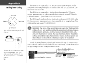
The GPS V can be hard-wired to a vehicle's electrical system and a PC, beacon receiver, marine autopilot, or other compatible device using the optional PC Interface Cable with bare wire leads be installed by experienced installers at the side and bottom of the Garmin Warranty require that the ...connection to a remote antenna: rotate to a 45° angle and gently pull away from the back of the GPS V and wiring leads are illustrated to a PC, beacon receiver, marine autopilot or other compatible device using the supplied PC Interface Cable with bare wire leads (P/N 010-10082-00)....
The GPS V can be hard-wired to a vehicle's electrical system and a PC, beacon receiver, marine autopilot, or other compatible device using the optional PC Interface Cable with bare wire leads be installed by experienced installers at the side and bottom of the Garmin Warranty require that the ...connection to a remote antenna: rotate to a 45° angle and gently pull away from the back of the GPS V and wiring leads are illustrated to a PC, beacon receiver, marine autopilot or other compatible device using the supplied PC Interface Cable with bare wire leads (P/N 010-10082-00)....
Owner's Manual
Page 84
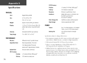
... x 160 pixels), high-contrast, 4-gray-level backlit LCD Detachable with BNC-type connector 5° to 158°F (-15° to 70°C)1 PERFORMANCE Receiver: Acquisition Time: Update Rate: GPS Accuracy Position: Velocity: Differential-ready 12 parallel channel Warm: Approximately 15 seconds Cold: Approximately 45 seconds AutoLocate™: Approximately 2 minutes Once per second...
... x 160 pixels), high-contrast, 4-gray-level backlit LCD Detachable with BNC-type connector 5° to 158°F (-15° to 70°C)1 PERFORMANCE Receiver: Acquisition Time: Update Rate: GPS Accuracy Position: Velocity: Differential-ready 12 parallel channel Warm: Approximately 15 seconds Cold: Approximately 45 seconds AutoLocate™: Approximately 2 minutes Once per second...

Owner's Manual
Page 86
... Average Location 24-25, 49 Average Speed 21-22 Avoid 59 B Backlight Timeout 55 Backlight, Adjusting 6 Battery Installation 1, 4 Battery Setting 55 Battery Timer 60 Beacon Receiver 62-63 Bearing Pointer 45, 47 Beeper Tones 55 76 Best Route 58 Big Numbers 47 C Calculation Method 58 Calculator 69 Calendar 64, 67-68...
... Average Location 24-25, 49 Average Speed 21-22 Avoid 59 B Backlight Timeout 55 Backlight, Adjusting 6 Battery Installation 1, 4 Battery Setting 55 Battery Timer 60 Beacon Receiver 62-63 Bearing Pointer 45, 47 Beeper Tones 55 76 Best Route 58 Big Numbers 47 C Calculation Method 58 Calculator 69 Calendar 64, 67-68...

Owner's Manual
Page 88
... 1, 70 Present Location 12 Present Position 12 Projected Waypoint 49 Proximity Alarm 62 Proximity Waypoint 62 Q Quickest Calculation 58 QUIT Key 2, 7 78 R Recalculate Route 42 Receiver Status 8-9 Recently Found Places 32 Reference Waypoint 49 Renaming Routes 36 Renaming Waypoints 48 Resetting Trip Information 23 Restore Defaults...........24, 38, 47, 56, 60...
... 1, 70 Present Location 12 Present Position 12 Projected Waypoint 49 Proximity Alarm 62 Proximity Waypoint 62 Q Quickest Calculation 58 QUIT Key 2, 7 78 R Recalculate Route 42 Receiver Status 8-9 Recently Found Places 32 Reference Waypoint 49 Renaming Routes 36 Renaming Waypoints 48 Resetting Trip Information 23 Restore Defaults...........24, 38, 47, 56, 60...

Brochure
Page 1
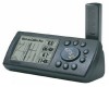
You can pinpoint your car's dash to within three meters on a bike or your location to vertical for handheld use. The GPS V is WAAS capable, which means it can even switch the display from the included MapSource™ City Select™ CD-ROM for ... interstates and more . The built-in this compact receiver. You can also download maps from horizontal for mounting on Precise GPS that creates routes automatically average. Look up a location and the GPS V will automatically calculate a route. WITH WAAS for even greater accuracy GPS V You'll be amazed at the accuracy and level...
You can pinpoint your car's dash to within three meters on a bike or your location to vertical for handheld use. The GPS V is WAAS capable, which means it can even switch the display from the included MapSource™ City Select™ CD-ROM for ... interstates and more . The built-in this compact receiver. You can also download maps from horizontal for mounting on Precise GPS that creates routes automatically average. Look up a location and the GPS V will automatically calculate a route. WITH WAAS for even greater accuracy GPS V You'll be amazed at the accuracy and level...

Brochure
Page 2
...typical Velocity: 0.05 meter/sec steady state Dynamics: 6g's Interfaces: RS232 with NMEA 0183, RTCM 104 DGPS data format and proprietary GARMIN Antenna: Detachable with standard BNC connector Differential: RTCM-104, WAAS Moving map features Basemap: Built-in celestial tables for best times to ... Position format: Lat/Lon, UTM/UPS, Maidenhead, MGRS, Loran TDs and other grids, including user grid GPS performance Receiver: WAAS enabled, 12 parallel channel GPS receiver continuously tracks and uses up to 50 points each. You can automatically create a route and display turn-by...
...typical Velocity: 0.05 meter/sec steady state Dynamics: 6g's Interfaces: RS232 with NMEA 0183, RTCM 104 DGPS data format and proprietary GARMIN Antenna: Detachable with standard BNC connector Differential: RTCM-104, WAAS Moving map features Basemap: Built-in celestial tables for best times to ... Position format: Lat/Lon, UTM/UPS, Maidenhead, MGRS, Loran TDs and other grids, including user grid GPS performance Receiver: WAAS enabled, 12 parallel channel GPS receiver continuously tracks and uses up to 50 points each. You can automatically create a route and display turn-by...

