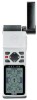
Owner's Manual
Page 5
...THREE Reference Satellite Page 14-15 Battery Level Indicator, Backlighting, and Emergency Erase 16 Position Page & User Selectable Fields 17-18 Map Page & Marine Database 19-21 Map Page, Zooming, Panning & Configuring 22-23 Map Page, Track Log, City, & Navaid Setup 24-27 Using the ...Destination & Man Overboard 38 TrackBack Navigation 39-40 Creating & Using Routes 41-45 Menu Page & Distance/Sun Calculation 46 System Setup 46-48 Navigation Setup 49-51 Interface Setup & DGPS Interface 52-53 Alarms Setup 54 Find City 55 Navigation Simulator 56 SECTION FOUR Appendices Appendix A--...
...THREE Reference Satellite Page 14-15 Battery Level Indicator, Backlighting, and Emergency Erase 16 Position Page & User Selectable Fields 17-18 Map Page & Marine Database 19-21 Map Page, Zooming, Panning & Configuring 22-23 Map Page, Track Log, City, & Navaid Setup 24-27 Using the ...Destination & Man Overboard 38 TrackBack Navigation 39-40 Creating & Using Routes 41-45 Menu Page & Distance/Sun Calculation 46 System Setup 46-48 Navigation Setup 49-51 Interface Setup & DGPS Interface 52-53 Alarms Setup 54 Find City 55 Navigation Simulator 56 SECTION FOUR Appendices Appendix A--...
Owner's Manual
Page 13
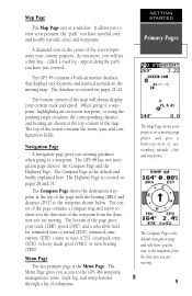
...bottom of submenus. The Menu Page gives you have just covered. It allows you to view your position, the "path" you access to the GPS 48's waypoint management, route, track log, and setup features through a list of the page gives your progress on pages 21-22. appear along the ... acts as a window. The bottom corners of the page with the bearing (BRG) and distance (DST) to a waypoint. A diamond icon in marine database that displays city locations and nautical navaids on -screen waypoint, or using the panning target crosshair, the corresponding distance and bearing are moving map...
...bottom of submenus. The Menu Page gives you have just covered. It allows you to view your position, the "path" you access to the GPS 48's waypoint management, route, track log, and setup features through a list of the page gives your progress on pages 21-22. appear along the ... acts as a window. The bottom corners of the page with the bearing (BRG) and distance (DST) to a waypoint. A diamond icon in marine database that displays city locations and nautical navaids on -screen waypoint, or using the panning target crosshair, the corresponding distance and bearing are moving map...

Owner's Manual
Page 23
..., including the bearing and distance to a destination waypoint and your bearing and distance to one of the page displays your present position as a solid line, marine database points (see pg. 24 for more information). The four corners of the Map Page. Map Page Zoom Scale Bearing to Waypoint Track Over Ground...
..., including the bearing and distance to a destination waypoint and your bearing and distance to one of the page displays your present position as a solid line, marine database points (see pg. 24 for more information). The four corners of the Map Page. Map Page Zoom Scale Bearing to Waypoint Track Over Ground...
Owner's Manual
Page 24
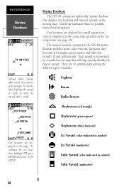
...Marine Database The GPS 48 contains an updateable, marine database that will help quickly identify the type of the navaids. The nautical navaids contained in symbol) Unlit Navaid (multicolor) 20 City locations are depicted by a symbol on the city setup menu (see page 26). City locations are displayed on the moving map. Check the Garmin... diamond) Lit Navaid (color indicated in symbol) Lit Navaid (multicolor) Unlit Navaid (color indicated in the GPS 48 marine database include racons, radio beacons, fog horns, daybeacons (red triangles, green squares and white diamonds), lit and...
...Marine Database The GPS 48 contains an updateable, marine database that will help quickly identify the type of the navaids. The nautical navaids contained in symbol) Unlit Navaid (multicolor) 20 City locations are depicted by a symbol on the city setup menu (see page 26). City locations are displayed on the moving map. Check the Garmin... diamond) Lit Navaid (color indicated in symbol) Lit Navaid (multicolor) Unlit Navaid (color indicated in the GPS 48 marine database include racons, radio beacons, fog horns, daybeacons (red triangles, green squares and white diamonds), lit and...

Owner's Manual
Page 25
... primary color displayed in the unit; There are many types. Radio Beacons act as "TR ON PILE", or a special designation code for RAdar beaCON. REFERENCE Marine Database Lit and unlit navaids are designated by the primary color. White, Red, Green, Orange, Yellow or Amber, Violet and Blue.... Marine Database (cont) Lit and unlit navaids are designated by their operating frequency and possibly the Morse Code characteristics assigned to that radio beacon by panning ...
... primary color displayed in the unit; There are many types. Radio Beacons act as "TR ON PILE", or a special designation code for RAdar beaCON. REFERENCE Marine Database Lit and unlit navaids are designated by the primary color. White, Red, Green, Orange, Yellow or Amber, Violet and Blue.... Marine Database (cont) Lit and unlit navaids are designated by their operating frequency and possibly the Morse Code characteristics assigned to that radio beacon by panning ...

Owner's Manual
Page 30
... track log at high zoom settings. For a detailed description of the TracBack feature. City Setup Page The city setup page lets you search the internal marine database for a TracBack. Highlight 'CITY SETUP', and press E. 2. REFERENCE Clearing the Track Log Clear the track log any time your trip, etc., in the City...
... track log at high zoom settings. For a detailed description of the TracBack feature. City Setup Page The city setup page lets you search the internal marine database for a TracBack. Highlight 'CITY SETUP', and press E. 2. REFERENCE Clearing the Track Log Clear the track log any time your trip, etc., in the City...
Owner's Manual
Page 71
Heading Reference . .50 Man Overboard Function .38 Map Cursor 23 Map Datums 49, 63 Map Orientation 24 Map Page 11, 18 Map Setup 24 Marine Database 21 Marking a Position . . . . . .32 Maximum Speed 18 Maximum Speed (MXSPD) 17 Menu Page 9, 46 Messages 61 N NMEA Formats 58 Navaid Setup 27 Navigating Routes . . . . . ....
Heading Reference . .50 Man Overboard Function .38 Map Cursor 23 Map Datums 49, 63 Map Orientation 24 Map Page 11, 18 Map Setup 24 Marine Database 21 Marking a Position . . . . . .32 Maximum Speed 18 Maximum Speed (MXSPD) 17 Menu Page 9, 46 Messages 61 N NMEA Formats 58 Navaid Setup 27 Navigating Routes . . . . . ....