
Pilots Guide
Page 2
... the USA Part Number 190-00607-02 Rev C © 2006-2007 Garmin Ltd. Information in any storage medium, for current updates and supplemental information concerning the use and operation of Garmin Ltd. Except as expressly provided herein, no part of this manual or... any purpose without the express permission of Garmin. Garmin hereby grants permission to download a single...
... the USA Part Number 190-00607-02 Rev C © 2006-2007 Garmin Ltd. Information in any storage medium, for current updates and supplemental information concerning the use and operation of Garmin Ltd. Except as expressly provided herein, no part of this manual or... any purpose without the express permission of Garmin. Garmin hereby grants permission to download a single...

Pilots Guide
Page 5
... Media" you fail to utilize, the Internet gaming or update features within the SOFTWARE, it is invalid. Its component parts may make copies of the SOFTWARE and all applicable international and national laws that will be automatically downloaded to contact Garmin for the GMX 200. THE SUPPLEMENTAL COMPONENTS AND ANY (IF ANY) SUPPORT SERVICES...
... Media" you fail to utilize, the Internet gaming or update features within the SOFTWARE, it is invalid. Its component parts may make copies of the SOFTWARE and all applicable international and national laws that will be automatically downloaded to contact Garmin for the GMX 200. THE SUPPLEMENTAL COMPONENTS AND ANY (IF ANY) SUPPORT SERVICES...
Pilots Guide
Page 6
... navigation needs in an easy to meet your Garmin dealer. Our products are the owner of the state-of product updates and new products and provides lost or stolen unit tracking. Introduction Accessories, Packing List, & Welcome Accessories and Packing List To obtain accessories for your GMX 200 please contact your needs as they change...
... navigation needs in an easy to meet your Garmin dealer. Our products are the owner of the state-of product updates and new products and provides lost or stolen unit tracking. Introduction Accessories, Packing List, & Welcome Accessories and Packing List To obtain accessories for your GMX 200 please contact your needs as they change...
Pilots Guide
Page 17
...side of the current function. When you to modify the display of the GMX 200. Do not touch the connector edge of the GMX 200. When fully inserted, the data card will change the data card when... and black (inactive). Menu Item Keys Menu Item Labels Data Card and Slot Handle your dealer or the Garmin customer service department, eject the data card and write down the information shown on a data card. Menu ... pull the card straight out of options to easily update information. Only Garmin-approved datacards can be flush and slightly recessed into the slot until it "clicks."
...side of the current function. When you to modify the display of the GMX 200. Do not touch the connector edge of the GMX 200. When fully inserted, the data card will change the data card when... and black (inactive). Menu Item Keys Menu Item Labels Data Card and Slot Handle your dealer or the Garmin customer service department, eject the data card and write down the information shown on a data card. Menu ... pull the card straight out of options to easily update information. Only Garmin-approved datacards can be flush and slightly recessed into the slot until it "clicks."

Pilots Guide
Page 38
...the selected time interval. Obstructions are part of this guide. Each reported lightning strike is an optional installation. For information on the Internal GMX 200-Based Terrain color coding, see the Terrain Function description in yellow; The Traffic function is shown as an "x" on the display. ...on or off. Traffic targets can also be overlaid on how traffic information is lost, objects are shown in the front of the GMX 200 updateable database. Strikes The Strikes menu option controls the display of menu items. 26 190-00607-02 Rev C When altitude data is used....
...the selected time interval. Obstructions are part of this guide. Each reported lightning strike is an optional installation. For information on the Internal GMX 200-Based Terrain color coding, see the Terrain Function description in yellow; The Traffic function is shown as an "x" on the display. ...on or off. Traffic targets can also be overlaid on how traffic information is lost, objects are shown in the front of the GMX 200 updateable database. Strikes The Strikes menu option controls the display of menu items. 26 190-00607-02 Rev C When altitude data is used....

Pilots Guide
Page 52
... maneuver. When this happens the pilot will see and avoid" other aircraft. Assume that not all aircraft are displayed as a TIS-B target. In comparison, the update rate for , nor authorized, as a direct result of their own aircraft, typically when maneuvering (e.g., climbing turn) due to the radar not tracking the aircraft as... aircraft is operating inside (or outside) the TIS-B Service Volume, therefore it is difficult to "see duplicate traffic symbols (i.e., "TIS-B shadows") on the cockpit display. (c) Updates of TIS-B traffic reports will occur less often than ADS-B traffic...
... maneuver. When this happens the pilot will see and avoid" other aircraft. Assume that not all aircraft are displayed as a TIS-B target. In comparison, the update rate for , nor authorized, as a direct result of their own aircraft, typically when maneuvering (e.g., climbing turn) due to the radar not tracking the aircraft as... aircraft is operating inside (or outside) the TIS-B Service Volume, therefore it is difficult to "see duplicate traffic symbols (i.e., "TIS-B shadows") on the cockpit display. (c) Updates of TIS-B traffic reports will occur less often than ADS-B traffic...
Pilots Guide
Page 62
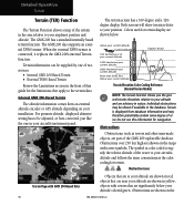
...with tower symbols. The symbol is connected, it replaces the GMX 200's internal Terrain function. Obstructions are advisory in yellow; Individual obstructions may therefore potentially contain some degree of the GMX 200 updateable database. Detailed Operation Terrain Terrain (TER) Function The Terrain... Function shows a map of the terrain in the database. The GMX 200 has a standard internally based terrain function. The GMX 200 also supports an external TAWS sensor. Internal GMX 200-Based ...
...with tower symbols. The symbol is connected, it replaces the GMX 200's internal Terrain function. Obstructions are advisory in yellow; Individual obstructions may therefore potentially contain some degree of the GMX 200 updateable database. Detailed Operation Terrain Terrain (TER) Function The Terrain... Function shows a map of the terrain in the database. The GMX 200 has a standard internally based terrain function. The GMX 200 also supports an external TAWS sensor. Internal GMX 200-Based ...

Pilots Guide
Page 69
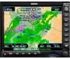
... key on the right to the last 12 images are operational or off-line is turned on each sub-function. This data is shown. The update rate is shown. The three pages of menu item selections allow you to the legend for current weather products and more detail on , Coverage, METARs...
... key on the right to the last 12 images are operational or off-line is turned on each sub-function. This data is shown. The update rate is shown. The three pages of menu item selections allow you to the legend for current weather products and more detail on , Coverage, METARs...

Pilots Guide
Page 70
...) are displayed. The movement is every five minutes. FIS Winds Aloft are shown as colored flags at airports that provide METAR reports. The update rate is depicted by the ground-based system. Refer to display the next page of cloud-to be shown as opposed to enable or disable...and cells are disabled. Lightning information indicates the location of menu items. 58 190-00607-02 Rev C The tip of the color code. The update rate is not available. NEXRAD animation detail showing image age When Nexrad animation is off-line (e.g. Areas where radar capability exists, but is not ...
...) are displayed. The movement is every five minutes. FIS Winds Aloft are shown as colored flags at airports that provide METAR reports. The update rate is depicted by the ground-based system. Refer to display the next page of cloud-to be shown as opposed to enable or disable...and cells are disabled. Lightning information indicates the location of menu items. 58 190-00607-02 Rev C The tip of the color code. The update rate is not available. NEXRAD animation detail showing image age When Nexrad animation is off-line (e.g. Areas where radar capability exists, but is not ...

Pilots Guide
Page 71
... Top GDL 69/69A FIS Cloud Tops NOTE: Cloud Tops and Echo Tops use the same color scaling to provide a view of the display. The update rate is shown in the lower right corner of weather trends. Detailed Operation GDL 69/69A - Selecting Nexrad Animation will step through a number of the...
... Top GDL 69/69A FIS Cloud Tops NOTE: Cloud Tops and Echo Tops use the same color scaling to provide a view of the display. The update rate is shown in the lower right corner of weather trends. Detailed Operation GDL 69/69A - Selecting Nexrad Animation will step through a number of the...

Pilots Guide
Page 72
... NEXRAD information and indicates the highest altitude at the bottom of Winds Aloft on and off . Wait for the next update. The selected altitude is every 7.5 minutes. The update rate is depicted in the Winds Aloft Alt menu item. The winds at the same time. Press MENU/ENT key ...Echo Tops on and off . FIS Echo Tops Echo Tops indicate the location, elevation, and direction the highest radar echo. The update rate is every 12 minutes. The update rate is every 12 minutes. Detailed Operation GDL 69/69A - This is falling. Winds Aloft The Winds Aloft selection provides the ...
... NEXRAD information and indicates the highest altitude at the bottom of Winds Aloft on and off . Wait for the next update. The selected altitude is every 7.5 minutes. The update rate is depicted in the Winds Aloft Alt menu item. The winds at the same time. Press MENU/ENT key ...Echo Tops on and off . FIS Echo Tops Echo Tops indicate the location, elevation, and direction the highest radar echo. The update rate is every 12 minutes. The update rate is every 12 minutes. Detailed Operation GDL 69/69A - This is falling. Winds Aloft The Winds Aloft selection provides the ...

Pilots Guide
Page 76
... Forecast (Fcst) sub-function. 3. The line alternates with orange and blue sections which point in the direction of how the weather systems are expected to update this information during the flight. Actual conditions may be displayed as "N/A" while animation is moving . The Surface Animate selection will be selected at any given...
... Forecast (Fcst) sub-function. 3. The line alternates with orange and blue sections which point in the direction of how the weather systems are expected to update this information during the flight. Actual conditions may be displayed as "N/A" while animation is moving . The Surface Animate selection will be selected at any given...

Pilots Guide
Page 77
... Turbulence • IFR conditions • Mountain obscuration • Surface winds Refer to the Legend for the selected services. The update rate is every 12 minutes. 2. The update rate is every 12 minutes. Press Done to display the next page of the Forecast Time key will step through times. AIRMET...this product. Use the menu item key below the City key to display the legends for a description of the color coding. 1. The update rate is every 12 minutes. When enabled, the following AIRMETs are available for intervals of weather that may be selected to display the ...
... Turbulence • IFR conditions • Mountain obscuration • Surface winds Refer to the Legend for the selected services. The update rate is every 12 minutes. 2. The update rate is every 12 minutes. Press Done to display the next page of the Forecast Time key will step through times. AIRMET...this product. Use the menu item key below the City key to display the legends for a description of the color coding. 1. The update rate is every 12 minutes. When enabled, the following AIRMETs are available for intervals of weather that may be selected to display the ...

Pilots Guide
Page 85
... no strikes will be shown. The last option selection (Next Page) takes you zoom Out to 30 NM strikes will be refreshed on the next update cycle. The 360 view shows a 360° view the airspace surrounding your Stormscope. Lightning The WX500 detects electrical discharges within a range determined by ...aid in locating strikes in the lower left corner of the Flight Plan course line. These discharge locations are reported by the navigator to the GMX 200 has an invalid cross track error, the ownship symbol will be shown, but if you to the next page of menu items. Lightning Function...
... no strikes will be shown. The last option selection (Next Page) takes you zoom Out to 30 NM strikes will be refreshed on the next update cycle. The 360 view shows a 360° view the airspace surrounding your Stormscope. Lightning The WX500 detects electrical discharges within a range determined by ...aid in locating strikes in the lower left corner of the Flight Plan course line. These discharge locations are reported by the navigator to the GMX 200 has an invalid cross track error, the ownship symbol will be shown, but if you to the next page of menu items. Lightning Function...

Pilots Guide
Page 88
... are loaded onto the data card is updated by FAA regulations. The FliteChart Function will retain the last view settings and will not change the chart, zoom level, or pan setting when the function is accessed by Garmin. Chart FliteChart (CHART) Function (Optional) The optional GMX 200 FliteChart feature provides the capability to a physical...
... are loaded onto the data card is updated by FAA regulations. The FliteChart Function will retain the last view settings and will not change the chart, zoom level, or pan setting when the function is accessed by Garmin. Chart FliteChart (CHART) Function (Optional) The optional GMX 200 FliteChart feature provides the capability to a physical...

Pilots Guide
Page 92
...may also be properly georeferenced with respect to a standard chart manual (north up) with a GNS 480-series GPS receiver. The GMX 200 ChartView feature does not currently represent a sole replacement for supplemental use and to the printed chart as a dynamic overlay on the ...of interest, then selecting the individual chart for locating a specific chart among the charts in the ChartView Function, more selection options are updated on the pilot removable frontloading data card and is displayed similar to the base map. The in a manual fashion. The electronic chart...
...may also be properly georeferenced with respect to a standard chart manual (north up) with a GNS 480-series GPS receiver. The GMX 200 ChartView feature does not currently represent a sole replacement for supplemental use and to the printed chart as a dynamic overlay on the ...of interest, then selecting the individual chart for locating a specific chart among the charts in the ChartView Function, more selection options are updated on the pilot removable frontloading data card and is displayed similar to the base map. The in a manual fashion. The electronic chart...

Pilots Guide
Page 105
... are set the bearing of the radar receiver. While in the hold mode, the green RDR indicator flashes indicating that the display is not being updated, but the radar is a cyan line extending along the Radar's projected path and can be displayed in the GWX 68. Once selected, changing the scan...
... are set the bearing of the radar receiver. While in the hold mode, the green RDR indicator flashes indicating that the display is not being updated, but the radar is a cyan line extending along the Radar's projected path and can be displayed in the GWX 68. Once selected, changing the scan...

Pilots Guide
Page 123
... signal to receive and decode this information. Corresponding Artist Name/ Feature or Song/Program Title are disconnected from the XM signal. Condition Antenna not connected Updating encryption code Loss of signal Acquiring channel audio or information Channel not in service Channel no longer available Description The XM antenna(s) or antenna cable... service ID) is temporarily unavailable for the chosen category 190-00607-02 Rev C 111 XM Advisory Messages Detailed Operation XM Satellite Radio Message Check Antenna Updating No Signal Loading Off Air --- or Channel --- --- ---
... signal to receive and decode this information. Corresponding Artist Name/ Feature or Song/Program Title are disconnected from the XM signal. Condition Antenna not connected Updating encryption code Loss of signal Acquiring channel audio or information Channel not in service Channel no longer available Description The XM antenna(s) or antenna cable... service ID) is temporarily unavailable for the chosen category 190-00607-02 Rev C 111 XM Advisory Messages Detailed Operation XM Satellite Radio Message Check Antenna Updating No Signal Loading Off Air --- or Channel --- --- ---

Pilots Guide
Page 145
... Transmit status 42 Transponder v, 12, 39, 41, 46, 126 Troubleshooting 117 Turbulence 65 Typical operational scenario 89 U UAT 1, 2, 6, 7, 12, 17, 37, 39, 41, 53, 126 Updating 111 V Vertical Filtering 35, 36 Vertical Mode 35, 92, 93 Vertical profile 2, 33 Vertical Range 36, 43 VFR 1, 2, 9, 17, 21, 31, 65, 126 View 1, 11...
... Transmit status 42 Transponder v, 12, 39, 41, 46, 126 Troubleshooting 117 Turbulence 65 Typical operational scenario 89 U UAT 1, 2, 6, 7, 12, 17, 37, 39, 41, 53, 126 Updating 111 V Vertical Filtering 35, 36 Vertical Mode 35, 92, 93 Vertical profile 2, 33 Vertical Range 36, 43 VFR 1, 2, 9, 17, 21, 31, 65, 126 View 1, 11...


