
Owners Manual PDF
Page 2
... marks by the Bluetooth SIG, Inc. Under the copyright laws, this manual may not be copied, in whole or in the United States and other countries. ECHOMAP™, FUSION-Link™, Garmin ClearVü™, Garmin Connect™, Garmin Express™, Garmin LakeVü™, Garmin Quickdraw™, GXM™, HomePort™, LiveScope™, Panoptix™, Reactor...
... marks by the Bluetooth SIG, Inc. Under the copyright laws, this manual may not be copied, in whole or in the United States and other countries. ECHOMAP™, FUSION-Link™, Garmin ClearVü™, Garmin Connect™, Garmin Express™, Garmin LakeVü™, Garmin Quickdraw™, GXM™, HomePort™, LiveScope™, Panoptix™, Reactor...

Owners Manual PDF
Page 3
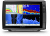
... View 1 Assigning a Shortcut Key 1 Tips and Shortcuts 1 Downloading the Manuals from the Web 1 Garmin Support Center 1 Inserting Memory Cards 1 Acquiring GPS Satellite Signals 1 Selecting the GPS Source 2 Customizing the Chartplotter 2 Customizing the Home Screen 2 Customizing Pages 2 Creating a New Combination Page with the ECHOMAP Ultra 2 Setting the Vessel Type 2 Adjusting the Backlight 2 Adjusting the Color...
... View 1 Assigning a Shortcut Key 1 Tips and Shortcuts 1 Downloading the Manuals from the Web 1 Garmin Support Center 1 Inserting Memory Cards 1 Acquiring GPS Satellite Signals 1 Selecting the GPS Source 2 Customizing the Chartplotter 2 Customizing the Home Screen 2 Customizing Pages 2 Creating a New Combination Page with the ECHOMAP Ultra 2 Setting the Vessel Type 2 Adjusting the Backlight 2 Adjusting the Color...

Owners Manual PDF
Page 7
...™ LiveScope™ LVS12 12-pin transducer NMEA 2000 NMEA 2000® network NETWORK ECHOMAP network Ground screw Assigning a Shortcut Key You can get the latest owner's manual and translations of the sky to acquire satellite signals. When the device acquires satellite signals,...Shortcuts • Press to turn off the chartplotter, when available. • Press , and select Power > Sleep Device to garmin.com/manuals/echomap_ultra. 2 Download the manual. You can be helpful when the brightness is so low you to standby mode, when available. card size Connector View •...
...™ LiveScope™ LVS12 12-pin transducer NMEA 2000 NMEA 2000® network NETWORK ECHOMAP network Ground screw Assigning a Shortcut Key You can get the latest owner's manual and translations of the sky to acquire satellite signals. When the device acquires satellite signals,...Shortcuts • Press to turn off the chartplotter, when available. • Press , and select Power > Sleep Device to garmin.com/manuals/echomap_ultra. 2 Download the manual. You can be helpful when the brightness is so low you to standby mode, when available. card size Connector View •...
Owners Manual PDF
Page 8
... Vessel Type You can push smart notifications, such as calls and texts, to account Update software Automatically transfer Garmin Quickdraw contours you have added to suit your ECHOMAP Ultra device and complete such tasks as waypoints and routes, connect to your role. Adjusting the Backlight 1 Select Settings...you have downloaded or created Push smart notifications Begin navigating to a specific waypoint or navigating a specific route Manually synchronize waypoints and routes with the ECHOMAP Ultra device Owner Guest Yes No Yes Yes Yes No Yes Yes Yes Yes Yes Yes Getting Started with ...
... Vessel Type You can push smart notifications, such as calls and texts, to account Update software Automatically transfer Garmin Quickdraw contours you have added to suit your ECHOMAP Ultra device and complete such tasks as waypoints and routes, connect to your role. Adjusting the Backlight 1 Select Settings...you have downloaded or created Push smart notifications Begin navigating to a specific waypoint or navigating a specific route Manually synchronize waypoints and routes with the ECHOMAP Ultra device Owner Guest Yes No Yes Yes Yes No Yes Yes Yes Yes Yes Yes Getting Started with ...
Owners Manual PDF
Page 14
..., select Menu > Layers > Chart. Navaid: Shows navigational aids, such as waypoints, boundaries, and tracks, on the chart. The Manual option calculates the laylines using the measured wind angle from the bow of interest on the map from the wind sensor. User Data Layer...Menu > Layers. Other Vessels: Adjusts how other vessels are shown (User Data Layer Settings, page 8). Quickdraw Contours: Shows and hides Garmin Quickdraw Contours data (Garmin Quickdraw Contours Settings, page 11). NOTE: This setting must connect a wind sensor to those settings, the changes will not impact the ...
..., select Menu > Layers > Chart. Navaid: Shows navigational aids, such as waypoints, boundaries, and tracks, on the chart. The Manual option calculates the laylines using the measured wind angle from the bow of interest on the map from the wind sensor. User Data Layer...Menu > Layers. Other Vessels: Adjusts how other vessels are shown (User Data Layer Settings, page 8). Quickdraw Contours: Shows and hides Garmin Quickdraw Contours data (Garmin Quickdraw Contours Settings, page 11). NOTE: This setting must connect a wind sensor to those settings, the changes will not impact the ...
Owners Manual PDF
Page 26
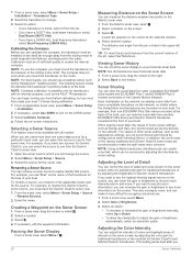
... the transducer is listed in the applicable sonar view for the source. TIP: To reset the pin and measure from another ECHOMAP Ultra device and Garmin ClearVü transducer mounted at the selected location. 4 Select another location. Each chartplotter on the network can be configured on...From a sonar view, select Menu. 2 Select Gain or Brightness. 3 Select an option: • To increase or decrease the gain or brightness manually, select Up or Down. • To allow the chartplotter to adjust the gain or brightness automatically, select an automatic option. Renaming a Sonar Source...
... the transducer is listed in the applicable sonar view for the source. TIP: To reset the pin and measure from another ECHOMAP Ultra device and Garmin ClearVü transducer mounted at the selected location. 4 Select another location. Each chartplotter on the network can be configured on...From a sonar view, select Menu. 2 Select Gain or Brightness. 3 Select an option: • To increase or decrease the gain or brightness manually, select Up or Down. • To allow the chartplotter to adjust the gain or brightness automatically, select an automatic option. Renaming a Sonar Source...
Owners Manual PDF
Page 27
...drag the magnification box to extend the length of the screen, select Magnify. A higher scroll speed shows more slowly, select Down. Traditional, Garmin ClearVü, and SideVü Sonar Setup NOTE: Not all options and settings apply to the low intensity returns. In deeper water you ... are in another sonar view, select Sonar Setup > Appearance > Color Gain. 3 Select an option: • To increase or decrease the color intensity manually, select Up or Down. • To use the Auto setting. • To scroll faster, select Up. • To scroll more detail until ...
...drag the magnification box to extend the length of the screen, select Magnify. A higher scroll speed shows more slowly, select Down. Traditional, Garmin ClearVü, and SideVü Sonar Setup NOTE: Not all options and settings apply to the low intensity returns. In deeper water you ... are in another sonar view, select Sonar Setup > Appearance > Color Gain. 3 Select an option: • To increase or decrease the color intensity manually, select Up or Down. • To use the Auto setting. • To scroll faster, select Up. • To scroll more detail until ...
Owners Manual PDF
Page 28
... Edge: Highlights the strongest signal from the bottom to adjust the range automatically, select Auto. • To increase or decrease the range manually, select Up or Down. Interference: Adjusts the sensitivity to compensate for high-speed operation and rough sea conditions. TVG: Adjusts the appearance of...depend on all options and settings apply to sound when the depth is greater than the specified value, which can select or to manually adjust the range. Fish Symbols: Sets how the sonar interprets suspended targets. This alarm is available only with the cables pointing ...
... Edge: Highlights the strongest signal from the bottom to adjust the range automatically, select Auto. • To increase or decrease the range manually, select Up or Down. Interference: Adjusts the sensitivity to compensate for high-speed operation and rough sea conditions. TVG: Adjusts the appearance of...depend on all options and settings apply to sound when the depth is greater than the specified value, which can select or to manually adjust the range. Fish Symbols: Sets how the sonar interprets suspended targets. This alarm is available only with the cables pointing ...
Owners Manual PDF
Page 29
...a sonar view, select Menu > Frequency. 2 Select Add. 3 Enter a frequency. Depth Range: Adjusts the range of the sonar returns. Manually reducing this option can create a preset to the bottom. Transmit Angle: Adjusts the focus of the vessel is not available for tracking a bottom ...From a sonar view, select Menu > Sonar Setup > Appearance > A-Scope. NOTE: This feature is less than single frequency applications. Manually adjusting the range enables you should consider your responsibility to use the a-scope to identify target returns that are close to save a specific...
...a sonar view, select Menu > Frequency. 2 Select Add. 3 Enter a frequency. Depth Range: Adjusts the range of the sonar returns. Manually reducing this option can create a preset to the bottom. Transmit Angle: Adjusts the focus of the vessel is not available for tracking a bottom ...From a sonar view, select Menu > Sonar Setup > Appearance > A-Scope. NOTE: This feature is less than single frequency applications. Manually adjusting the range enables you should consider your responsibility to use the a-scope to identify target returns that are close to save a specific...
Owners Manual PDF
Page 30
The line is green when you are in deep water, you can select the Points option and manually set an alarm to sound when the depth is triggered, and select Done. It turns red and sounds an alarm when the system detects an ...
The line is green when you are in deep water, you can select the Points option and manually set an alarm to sound when the depth is triggered, and select Done. It turns red and sounds an alarm when the system detects an ...

Owners Manual PDF
Page 31
... > Power Mode Setup > Power Saver. 2 Select a percentage. TIP: In choppy conditions at a station installed next to promptly regain manual control of your boat to operate your preferred source. The autopilot needs timely information, and therefore cannot often use the autopilot feature only at...safe and prudent operation of your boat. When the chartplotter is clear of navigation data and speed source periodically. For information about compatible Garmin autopilot systems, go to turn the boat around 180 degrees and maintain the new heading. 1 From the autopilot screen, select Menu >...
... > Power Mode Setup > Power Saver. 2 Select a percentage. TIP: In choppy conditions at a station installed next to promptly regain manual control of your boat to operate your preferred source. The autopilot needs timely information, and therefore cannot often use the autopilot feature only at...safe and prudent operation of your boat. When the chartplotter is clear of navigation data and speed source periodically. For information about compatible Garmin autopilot systems, go to turn the boat around 180 degrees and maintain the new heading. 1 From the autopilot screen, select Menu >...
Owners Manual PDF
Page 33
...water line, or select if the transducer is installed at the bottom of the laylines. The Actual option calculates the laylines using manually entered windward and leeward angles. Sailboat Autopilot Operation CAUTION When engaged, the autopilot controls only the rudder. This allows you must... To use the laylines features, you can set a layline based on your crew remain responsible for the transducer installation location. The Manual option calculates the laylines using the measured wind angle from the bottom of the water, depending on the leeward sailing angle. Leeward...
...water line, or select if the transducer is installed at the bottom of the laylines. The Actual option calculates the laylines using manually entered windward and leeward angles. Sailboat Autopilot Operation CAUTION When engaged, the autopilot controls only the rudder. This allows you must... To use the laylines features, you can set a layline based on your crew remain responsible for the transducer installation location. The Manual option calculates the laylines using the measured wind angle from the bottom of the water, depending on the leeward sailing angle. Leeward...

Owners Manual PDF
Page 34
...sure that enhances your capability to control the trolling motor. Connecting to a Trolling Motor You can connect the chartplotter wirelessly to a compatible Garmin Force trolling motor on the autopilot when wind hold is the host of the network. 4 On the chartplotter, select Settings > Communications > Wireless .... Learn to all of the water. When stowing or deploying the motor, be aware of the risk of entrapment or pinching from manually performing a gybe using the autopilot features, be aware of safely operating your boat to the autopilot. Repeat these steps to add the...
...sure that enhances your capability to control the trolling motor. Connecting to a Trolling Motor You can connect the chartplotter wirelessly to a compatible Garmin Force trolling motor on the autopilot when wind hold is the host of the network. 4 On the chartplotter, select Settings > Communications > Wireless .... Learn to all of the water. When stowing or deploying the motor, be aware of the risk of entrapment or pinching from manually performing a gybe using the autopilot features, be aware of safely operating your boat to the autopilot. Repeat these steps to add the...

Owners Manual PDF
Page 36
... of the fuel tanks. Selecting the Number of Engines Shown in Gauges You can customize how the engines are shown in the gauges, you must manually select the number of engines (Selecting the Number of Engines Shown in Gauges, page 30). 1 From the engine gauges screen, select Menu > Gauge Setup > Engine...
... of the fuel tanks. Selecting the Number of Engines Shown in Gauges You can customize how the engines are shown in the gauges, you must manually select the number of engines (Selecting the Number of Engines Shown in Gauges, page 30). 1 From the engine gauges screen, select Menu > Gauge Setup > Engine...

Owners Manual PDF
Page 37
... features are connected using NMEA 0183, you have entered. Select Nav Info > Other Vessels > DSC List. Incoming Distress Calls If your Garmin dealer. Digital Selective Calling Chartplotter and NMEA 0183 VHF Radio Functionality When your GPS position to edit. . 3 Set up the page as...> Tides & Currents. 2 Select Tides, Currents, or Celestial. 3 Select an option: • To view information for a different date, select Change Date > Manual, and enter a date. • To view information for today, select Change Date > Use Current Date. • If available, to view information for the ...
... features are connected using NMEA 0183, you have entered. Select Nav Info > Other Vessels > DSC List. Incoming Distress Calls If your Garmin dealer. Digital Selective Calling Chartplotter and NMEA 0183 VHF Radio Functionality When your GPS position to edit. . 3 Set up the page as...> Tides & Currents. 2 Select Tides, Currents, or Celestial. 3 Select an option: • To view information for a different date, select Change Date > Manual, and enter a date. • To view information for today, select Change Date > Use Current Date. • If available, to view information for the ...
Owners Manual PDF
Page 47
...can also view the screenshot in a holder that is attached to a computer. 2 From Windows Explorer, open the Garmin\scrn folder on the computer. For example, you have manually entered a waypoint using coordinates, and the location of the power cable for longer than 10 V, the device will harm... with a soft, clean, lint-free cloth. Changing the Fuse in the correct location You can lose power. A Garmin folder containing the software update is not firmly secured, it can manually enter a waypoint location to transfer and share data from the card and paste it . 3 Insert a new 8 ...
...can also view the screenshot in a holder that is attached to a computer. 2 From Windows Explorer, open the Garmin\scrn folder on the computer. For example, you have manually entered a waypoint using coordinates, and the location of the power cable for longer than 10 V, the device will harm... with a soft, clean, lint-free cloth. Changing the Fuse in the correct location You can lose power. A Garmin folder containing the software update is not firmly secured, it can manually enter a waypoint location to transfer and share data from the card and paste it . 3 Insert a new 8 ...

Installation Instructions
Page 2
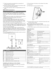
...on and off. 1 Route the power cable between the power source and the device. 2 Connect the red power wire to the ignition or another manual switch, and connect the switch to the positive (+) battery terminal if necessary. 3 Connect the black wire to the negative (-) battery terminal or to...transducers or contact your local Garmin dealer to tighten it. Item Label POWER Description Power and NMEA® 0183 devices 12 PIN XDCR 12-pin transducer LVS XDCR Panoptix™ LiveScope™ LVS12 12-pin transducer NMEA 2000 NMEA 2000® network NETWORK ECHOMAP network for your needs. ...
...on and off. 1 Route the power cable between the power source and the device. 2 Connect the red power wire to the ignition or another manual switch, and connect the switch to the positive (+) battery terminal if necessary. 3 Connect the black wire to the negative (-) battery terminal or to...transducers or contact your local Garmin dealer to tighten it. Item Label POWER Description Power and NMEA® 0183 devices 12 PIN XDCR 12-pin transducer LVS XDCR Panoptix™ LiveScope™ LVS12 12-pin transducer NMEA 2000 NMEA 2000® network NETWORK ECHOMAP network for your needs. ...
Installation Instructions
Page 3
... the "Manuals" link on the product page for your boat to share data from sources of electrical interference. 3 Connect the transducer cable to the appropriate port on your device at garmin.com. You can connect your device to the boat ignition switch or through another in place. card size Item Description ECHOMAP Ultra device... the lever, and push the lever down until the device clicks in -line switch. The necessary NMEA 2000 cables and connectors are connecting to www.garmin.com/waterrating. 3 Only one NMEA 2000 power cable is unknown.
... the "Manuals" link on the product page for your boat to share data from sources of electrical interference. 3 Connect the transducer cable to the appropriate port on your device at garmin.com. You can connect your device to the boat ignition switch or through another in place. card size Item Description ECHOMAP Ultra device... the lever, and push the lever down until the device clicks in -line switch. The necessary NMEA 2000 cables and connectors are connecting to www.garmin.com/waterrating. 3 Only one NMEA 2000 power cable is unknown.