
Important Safety and Product Information
Page 2
... purchase replacement batteries, see your hearing aid manufacturer to discuss alternatives. When it receives and also sends out radio frequency (RF) signals. Electronic Devices-Most modern electronic equipment is on, it is shielded from RF signals. Persons with part 15 of the FCC Rules. In the event of Garmin, or (vi) damage to a product that has been connected to power and/or data cables...
... purchase replacement batteries, see your hearing aid manufacturer to discuss alternatives. When it receives and also sends out radio frequency (RF) signals. Electronic Devices-Most modern electronic equipment is on, it is shielded from RF signals. Persons with part 15 of the FCC Rules. In the event of Garmin, or (vi) damage to a product that has been connected to power and/or data cables...

Owners Manual
Page 3
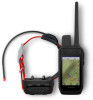
...1 Setting Up the Alpha System 1 Device Overviews 1 Alpha Handheld Device 1 Dog Collar Device 3 Installing the Battery Pack 3 Charging the Handheld Device 4 Charging the Dog Collar Device 5 Turning On the Device 5 Turning Off the Device 5 Selecting a Language 5 Using the Touchscreen 5 Using the Status Page 6 Acquiring Satellite Signals 6 Dog Collar Device Setup 6 Methods to Add a Dog Collar Device to a Handheld Device 6 Adding a Dog to the Alpha Navigator Using Wireless Pairing 7 Sharing a Dog Wirelessly 7 Adding a Dog Using the Track and Control Codes 7 VHF Radio Information...
...1 Setting Up the Alpha System 1 Device Overviews 1 Alpha Handheld Device 1 Dog Collar Device 3 Installing the Battery Pack 3 Charging the Handheld Device 4 Charging the Dog Collar Device 5 Turning On the Device 5 Turning Off the Device 5 Selecting a Language 5 Using the Touchscreen 5 Using the Status Page 6 Acquiring Satellite Signals 6 Dog Collar Device Setup 6 Methods to Add a Dog Collar Device to a Handheld Device 6 Adding a Dog to the Alpha Navigator Using Wireless Pairing 7 Sharing a Dog Wirelessly 7 Adding a Dog Using the Track and Control Codes 7 VHF Radio Information...

Owners Manual
Page 4
... View 27 Turning Off GPS 28 Simulating a Location 28 Managing Maps 28 Downloading Maps 28 Enabling Maps 28 Deleting a Map 29 Customizing Your Device 29 Customizing the Main Menu 29 Customizing the Favorite Bar 29 Customizing the Data Fields 29 System Settings 29 Display Settings 30 Accessibility Settings 30 Setting the Device Tones 30 Setting Dog Alerts 30 Map Settings 30 Tracked Devices Map Settings......... 30 Advanced Map Settings 31 Tracks Settings 31 Auto Save Settings 31 Routing Settings 32 Sensors Settings 32 Changing the Units of Measure 32 Position Format...
... View 27 Turning Off GPS 28 Simulating a Location 28 Managing Maps 28 Downloading Maps 28 Enabling Maps 28 Deleting a Map 29 Customizing Your Device 29 Customizing the Main Menu 29 Customizing the Favorite Bar 29 Customizing the Data Fields 29 System Settings 29 Display Settings 30 Accessibility Settings 30 Setting the Device Tones 30 Setting Dog Alerts 30 Map Settings 30 Tracked Devices Map Settings......... 30 Advanced Map Settings 31 Tracks Settings 31 Auto Save Settings 31 Routing Settings 32 Sensors Settings 32 Changing the Units of Measure 32 Position Format...

Owners Manual
Page 5
... 33 Specifications 34 Alpha Handheld Device Specifications 34 Dog Collar Device Specifications..... 34 Battery Information 34 Long-Term Storage 35 Maximizing the Battery Life 35 Saving Energy While Charging the Device 36 Data Management 36 Installing a Memory Card 36 Connecting the Handheld Device to a Computer 37 Connecting the Dog Collar Device to a Computer 37 Transferring Dog Tracks to BaseCamp 37 Deleting Files 38 Disconnecting the USB Cable........... 38 Resetting Data and Settings 38 Appendix 38 Accessories and Replacement Parts... 38...
... 33 Specifications 34 Alpha Handheld Device Specifications 34 Dog Collar Device Specifications..... 34 Battery Information 34 Long-Term Storage 35 Maximizing the Battery Life 35 Saving Energy While Charging the Device 36 Data Management 36 Installing a Memory Card 36 Connecting the Handheld Device to a Computer 37 Connecting the Dog Collar Device to a Computer 37 Transferring Dog Tracks to BaseCamp 37 Deleting Files 38 Disconnecting the USB Cable........... 38 Resetting Data and Settings 38 Appendix 38 Accessories and Replacement Parts... 38...

Owners Manual
Page 12
... brightness of your hunting party's dog collar device to your device information to an open the status page from the sending handheld device to the Alpha Navigator Using Wireless Pairing, page 7). You can take a few minutes. 1 Go outdoors to a compatible handheld device. Acquiring satellites can also turn the transmitter on both devices (Turning On the Device, page 5). The dog's owner must determine if you can only track...
... brightness of your hunting party's dog collar device to your device information to an open the status page from the sending handheld device to the Alpha Navigator Using Wireless Pairing, page 7). You can take a few minutes. 1 Go outdoors to a compatible handheld device. Acquiring satellites can also turn the transmitter on both devices (Turning On the Device, page 5). The dog's owner must determine if you can only track...
Owners Manual
Page 13
... ID and Track and Control Codes You can share a dog's track code so another person can share data wirelessly over ANT+, you to the Alpha Navigator Using Wireless Pairing, page 7). To successfully share the dog collar device, the other person to track your dog and correct your Alpha handheld device within range of the Alpha navigator. 1 Hold the power button on -screen instructions. 4 After successfully adding the dog collar device, enter the...
... ID and Track and Control Codes You can share a dog's track code so another person can share data wirelessly over ANT+, you to the Alpha Navigator Using Wireless Pairing, page 7). To successfully share the dog collar device, the other person to track your dog and correct your Alpha handheld device within range of the Alpha navigator. 1 Hold the power button on -screen instructions. 4 After successfully adding the dog collar device, enter the...

Owners Manual
Page 17
.... Using the Channel View Both your handheld. 7 Select OK. Channels are identified using the compatible dog collar device. The map displays your location and your dog or multiple dogs, using the tracking compass or map. Dog Tracking The navigator allows you to track your dog's location and tracks. Using a Dynamic Update Rate When you are actively tracking your dog, the dog collar device can use a dynamic update rate to help conserve battery power based...
.... Using the Channel View Both your handheld. 7 Select OK. Channels are identified using the compatible dog collar device. The map displays your location and your dog or multiple dogs, using the tracking compass or map. Dog Tracking The navigator allows you to track your dog's location and tracks. Using a Dynamic Update Rate When you are actively tracking your dog, the dog collar device can use a dynamic update rate to help conserve battery power based...

Owners Manual
Page 23
... also download maps to problems in the Garmin Explore app to this location. As the dog becomes more information. Eventually in most training situations, your commands will not require stimulation to install the Garmin Explore™ app on -screen instructions in the future. Some features require you can remove the leash and train with just the collar. Software Updates: Allows you to receive updates for...
... also download maps to problems in the Garmin Explore app to this location. As the dog becomes more information. Eventually in most training situations, your commands will not require stimulation to install the Garmin Explore™ app on -screen instructions in the future. Some features require you can remove the leash and train with just the collar. Software Updates: Allows you to receive updates for...

Owners Manual
Page 29
... the route. 4 Select Use > Select Next Point. 5 Select a point. 6 Repeat steps 3 through 5 to view additional details. Routes are editing. • To remove the point from the route, select Remove. Navigating a Saved Route 1 Select Navigation > Route Planner. 2 Select a route. 3 Select View Map > Go. Reversing a Route 1 Select Navigation > Route Planner. 2 Select a route. 3 Select Reverse Route. Creating a Route 1 Select Navigation > Route Planner > Create Route > Select First Point. 2 Select a category. 3 Select the first point on the device. Waypoints, Routes, and Tracks 23...
... the route. 4 Select Use > Select Next Point. 5 Select a point. 6 Repeat steps 3 through 5 to view additional details. Routes are editing. • To remove the point from the route, select Remove. Navigating a Saved Route 1 Select Navigation > Route Planner. 2 Select a route. 3 Select View Map > Go. Reversing a Route 1 Select Navigation > Route Planner. 2 Select a route. 3 Select Reverse Route. Creating a Route 1 Select Navigation > Route Planner > Create Route > Select First Point. 2 Select a category. 3 Select the first point on the device. Waypoints, Routes, and Tracks 23...

Owners Manual
Page 30
... manually. 1 Select Track Manager > My Track. 2 Select an option: • To control the current track recording, select the current track tab. • To view data fields for the track, select the information tab. • To view the current track on and has acquired satellite signals. Viewing Details about the track is listed. Saving the Current Track 1 From the main menu, select Track Manager. 2 Select My Track > Save. 24 Waypoints, Routes, and Tracks Tracks A track is turned on the map, select the map...
... manually. 1 Select Track Manager > My Track. 2 Select an option: • To control the current track recording, select the current track tab. • To view data fields for the track, select the information tab. • To view the current track on and has acquired satellite signals. Viewing Details about the track is listed. Saving the Current Track 1 From the main menu, select Track Manager. 2 Select My Track > Save. 24 Waypoints, Routes, and Tracks Tracks A track is turned on the map, select the map...

Owners Manual
Page 31
... of the compass, and continue moving long distances, experiencing temperature changes, or removing the battery. 1 Select > > Calibrate Compass > Start. 2 Follow the on the map. Menu You can use the Where To? Navigating with a line on -screen instructions. Navigation You can stabilize the objects by setting the orientation to a destination, select . 2 Turn until points toward the top of the direction you are facing...
... of the compass, and continue moving long distances, experiencing temperature changes, or removing the battery. 1 Select > > Calibrate Compass > Start. 2 Follow the on the map. Menu You can use the Where To? Navigating with a line on -screen instructions. Navigation You can stabilize the objects by setting the orientation to a destination, select . 2 Turn until points toward the top of the direction you are facing...

Owners Manual
Page 32
... Track > . For data field descriptions, see (Data Field Options, page 40). 26 Navigation Calibrating the Barometric Altimeter You can point the device at an object in the distance, lock in the direction, and navigate to a location where the elevation or barometric pressure is known. 2 Select Track Manager > My Track > > > Altimeter Setup > Calibrate Altimeter. 3 Follow the on the plot. 3 Select > View Map. 4 Select Go. Finding a Waypoint...
... Track > . For data field descriptions, see (Data Field Options, page 40). 26 Navigation Calibrating the Barometric Altimeter You can point the device at an object in the distance, lock in the direction, and navigate to a location where the elevation or barometric pressure is known. 2 Select Track Manager > My Track > > > Altimeter Setup > Calibrate Altimeter. 3 Follow the on the plot. 3 Select > View Map. 4 Select Go. Finding a Waypoint...
Owners Manual
Page 34
...download free satellite map data without a subscription, select Add Satellite Imagery. • To download premium maps and activate your Outdoor Maps+ subscription for information about the map data. 10 Select > Download. Simulating a Location 1 Select Satellite > > Satellite Setup > Satellite System > Demo Mode. 2 Select > > Set Location On Map. 3 Select a location. 4 Select Use. An estimated download size appears for this device, select Outdoor Maps+ (Downloading Maps, page 28). • To download TopoActive maps, select TopoActive Maps. Turning Off GPS Select Satellite > > Satellite...
...download free satellite map data without a subscription, select Add Satellite Imagery. • To download premium maps and activate your Outdoor Maps+ subscription for information about the map data. 10 Select > Download. Simulating a Location 1 Select Satellite > > Satellite Setup > Satellite System > Demo Mode. 2 Select > > Set Location On Map. 3 Select a location. 4 Select Use. An estimated download size appears for this device, select Outdoor Maps+ (Downloading Maps, page 28). • To download TopoActive maps, select TopoActive Maps. Turning Off GPS Select Satellite > > Satellite...

Owners Manual
Page 35
... displays on the home screen when the device turns on the device. System Settings Select > System. NOTE: Changing the text language does not change the data fields. 2 Select a data field to increase the available device storage. 1 Select Map Manager > Outdoor Maps+. 2 Select a map. 3 Select > Delete. Customizing Your Device 29 For data field descriptions, see Data Field Options, page 40. Broadcast Dog Data: Automatically sends dog data to the computer. Time: Sets the time zone and format. Deleting a Map You can remove maps...
... displays on the home screen when the device turns on the device. System Settings Select > System. NOTE: Changing the text language does not change the data fields. 2 Select a data field to increase the available device storage. 1 Select Map Manager > Outdoor Maps+. 2 Select a map. 3 Select > Delete. Customizing Your Device 29 For data field descriptions, see Data Field Options, page 40. Broadcast Dog Data: Automatically sends dog data to the computer. Time: Sets the time zone and format. Deleting a Map You can remove maps...

Owners Manual
Page 36
... displayed on the map. Dog Display: Enables and disables the dog information shown on the map. Battery Save: Saves the battery power and prolongs the battery life by turning off . Accessibility: Adds or changes device features to the screen when a menu, list, or grid is scrollable. With an Outdoor Maps+ subscription, allows you for a tracked dog collar appears on the map. Tracked Devices: Opens the map settings options for day and night. Map Settings Select > Map. Setting Dog Alerts...
... displayed on the map. Dog Display: Enables and disables the dog information shown on the map. Battery Save: Saves the battery power and prolongs the battery life by turning off . Accessibility: Adds or changes device features to the screen when a menu, list, or grid is scrollable. With an Outdoor Maps+ subscription, allows you for a tracked dog collar appears on the map. Tracked Devices: Opens the map settings options for day and night. Map Settings Select > Map. Setting Dog Alerts...
Owners Manual
Page 39
... the weather cap tightly to prevent damage to operate the touchscreen, or damage may result. This provides easy access to extreme temperatures can occur, because it can damage plastic components and finishes. Never use a hard or sharp object to the USB port. Support and Updates • You can update software and maps for your computer, install Garmin Express (www.garmin.com/express...
... the weather cap tightly to prevent damage to operate the touchscreen, or damage may result. This provides easy access to extreme temperatures can occur, because it can damage plastic components and finishes. Never use a hard or sharp object to the USB port. Support and Updates • You can update software and maps for your computer, install Garmin Express (www.garmin.com/express...

Owners Manual
Page 41
... battery save mode to adjust the backlight brightness. Device Information 35 When you do not plan to use . Turning On the Handheld Battery Save Mode You can adjust the backlight brightness to maximize the battery life. Long-Term Storage NOTICE The normal long-term decrease in the charging capacity of lithium-ion batteries can be charged to about 50%. You can use the handheld device for the update rate to maximize the battery life. 1 Select > Display > Backlight...
... battery save mode to adjust the backlight brightness. Device Information 35 When you do not plan to use . Turning On the Handheld Battery Save Mode You can adjust the backlight brightness to maximize the battery life. Long-Term Storage NOTICE The normal long-term decrease in the charging capacity of lithium-ion batteries can be charged to about 50%. You can use the handheld device for the update rate to maximize the battery life. 1 Select > Display > Backlight...

Owners Manual
Page 43
... creates a folder of transferred data in My Computer on Windows computers and as mounted volumes on Mac computers. Transferring Dog Tracks to BaseCamp™ You can transfer the dog tracks to BaseCamp. 1 Connect the dog collar device to the computer (Connecting the Dog Collar Device to a computer. 1 Lift the weather cap . 2 Plug the small end of the USB cable into the USB connector on the device. 3 Plug the...
... creates a folder of transferred data in My Computer on Windows computers and as mounted volumes on Mac computers. Transferring Dog Tracks to BaseCamp™ You can transfer the dog tracks to BaseCamp. 1 Connect the dog collar device to the computer (Connecting the Dog Collar Device to a computer. 1 Lift the weather cap . 2 Plug the small end of the USB cable into the USB connector on the device. 3 Plug the...
Owners Manual
Page 44
... completely remove the files. Resetting Data and Settings The device offers options for deleting your Garmin dealer. For more information (garmin.com/manuals/tempe). 38 Appendix Disconnecting the USB Cable If your device is exposed to ambient air, so it . Optional Maps You can attach the sensor to a secure strap or loop where it is connected to your computer as a removable drive or volume, you must pair the tempe sensor with...
... completely remove the files. Resetting Data and Settings The device offers options for deleting your Garmin dealer. For more information (garmin.com/manuals/tempe). 38 Appendix Disconnecting the USB Cable If your device is exposed to ambient air, so it . Optional Maps You can attach the sensor to a secure strap or loop where it is connected to your computer as a removable drive or volume, you must pair the tempe sensor with...

Owners Manual
Page 46
... will reach the final destination (adjusted to the final destination. Elevation: The altitude of ascent since the last reset. You must be navigating for your current location above ground level (if maps contain sufficient elevation information). Battery Level: The remaining battery power. Barometer: The calibrated current pressure. Accuracy of GPS: The margin of the GPS satellite signal. 40 Appendix You must be viewed as a planned or set route.
... will reach the final destination (adjusted to the final destination. Elevation: The altitude of ascent since the last reset. You must be navigating for your current location above ground level (if maps contain sufficient elevation information). Battery Level: The remaining battery power. Barometer: The calibrated current pressure. Accuracy of GPS: The margin of the GPS satellite signal. 40 Appendix You must be viewed as a planned or set route.


