
Garmin eTrex 20 Support Question
Garmin eTrex 20 Support Question
Find answers below for this question about Garmin eTrex 20.Need a Garmin eTrex 20 manual? We have 2 online manuals for this item!
Question posted by Brattep on February 7th, 2014
How Locate Memory Capacity On My Garmin Etrex 20
The person who posted this question about this Garmin product did not include a detailed explanation. Please use the "Request More Information" button to the right if more details would help you to answer this question.
Current Answers
Related Garmin eTrex 20 Manual Pages
Owner's Manual - Page 7

...counter-clockwise, and pull up to 70°C) may exceed the usable range of their capacity as temperature decreases. Replace the battery cover, and turn the D-ring clockwise.
4. Hold... Use NiMH or lithium batteries for the device (-4°F to 158°F, or -20 to remove the cover.
3. eTrex Owner's Manual
7
Battery Information
‹ warning The temperature rating for best results.
...
Owner's Manual - Page 11

...Location by Name Depending on the maps loaded on the eTrex 20 and eTrex 30, such as restaurants or marine services. Select a category.
3. If necessary, select a location.
Select Where To?.
2. Finding a Location Near Another Location 1.
eTrex...select Done. menu to find a destination to navigate to http://buy.garmin.com or contact your device, you can use the Where To? Enter...
Owner's Manual - Page 14

...Often interval provides the most track detail, but fills up the device memory quicker.
• Enter a time or distance, and select Done.... option:
• To record tracks at a specified time, select Time.
5. eTrex Owner's Manual
Select Setup > Tracks > Track
Log.
2. Select Record, Do ...including time, location, and elevation for each point. Waypoints, Routes, and Tracks
Tracks
A track...
Owner's Manual - Page 17

... a Driving Route Driving route navigation is using the automotive profile, the compass displays GPS heading, not magnetic heading. If you plan to use an auto mount accessory with...top of the map. eTrex Owner's Manual
17 Follow the turns in your destination.
• Select a location on the eTrex 20 and eTrex 30.
Navigation
Compass
The eTrex 30 has a 3-axis, electronic compass...
Owner's Manual - Page 24

... area, the device sounds a tone (eTrex 20/30).
24
eTrex Owner's Manual Sending and Receiving Data Wirelessly Before you must be within a specified range of a compatible Garmin device.
1. Select Use.
6. Follow the on-screen instructions. Select Done. You can share information wirelessly. Select a location.
5.
Applications
Applications
Sharing Data
The eTrex 30 can share waypoints...
Owner's Manual - Page 26

... view and to be oriented with your current location, GPS accuracy, satellite locations, and signal strength. The alarm sounds at the alarm time, the device turns on at a specific time.
1.
Satellite Page
The satellite page shows your current track toward the top of that satellite (eTrex 20/30). Select the clock numbers to turn on...
Owner's Manual - Page 30

... Note: To adjust the backlight brightness, see page 40.
• Colors (eTrex 20/30)-sets the colors that display in Night and Day mode.
◦◦ Mode-sets a light background... Navigation Overlay Service), or Demo Mode (GPS off . Display Settings
Select Setup > Display.
• Backlight Timeout-adjusts the length of AA battery you to http://www.garmin.com/ aboutGPS/waas.html.
• Language...
Owner's Manual - Page 33

...allows you are saved and cleared automatically based on the user setting.
• Color (eTrex 20/30)-changes the color of Measure
You can select Automatic to set the time zone automatically... position format in which a given location reading appears. Select Setup > Units.
2.
• Auto Archive-selects an automatic archive method to organize your GPS position. Changing the Units of the...
Owner's Manual - Page 37

Customizing Your Device
Marine Map Settings
This function is available on the map. eTrex Owner's Manual
37
Select Setup > Marine.
• Marine Chart Mode-...
◦◦ Fishing-(requires marine maps) displays a detailed view of marine navigation aids on the eTrex 20 and eTrex 30.
Simplifies map presentation for optimal use while fishing.
• Appearance-allows you to set the appearance...
Owner's Manual - Page 43

... up to remove the cover.
2. Also, some maps are available preloaded on memory cards. File Types The device supports these file types.
• Files from the Garmin POI Loader
• GPX geocache files
Device Information
Installing a microSD Card The eTrex 20 and eTrex 30 can use microSD cards for more information.
1.
It is not compatible...
Owner's Manual - Page 55

... 40 driving routes 37
E editing
profiles 30 routes 12 waypoints 9
eTrex Owner's Manual
elevation plot 19, 20 barometric altimeter 20 of a track 15
F file types 43 finding
addresses 12 near your location 11 fishing times 25 fitness options 46
G geocaches 21, 35
downloading... restore 39 setup 32 viewing routes 13 marine settings 37-38 measuring area 25 memory card 43 microSD card 43 moon phase 25
55
Quick Start Manual - Page 2
... a destination (page 8).
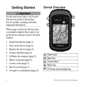
➊
➋
➌
➍
➎
➊ Zoom keys ➋ Back key ➌ Thumb Stick™ ➍ Menu key
➎ Power and backlight key
2
eTrex 20/30 Quick Start Manual Getting Started
Device Overview
‹ warning See the Important Safety and Product Information guide in the product box for product warnings...
Quick Start Manual - Page 3
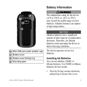
...;F, or -20°C to remove the cover. Installing AA Batteries You can rupture at high temperatures. Turn the D-ring counter-clockwise, and pull up to 70°C) may exceed the usable range of their capacity as temperature ... below-freezing conditions. The device operates on two AA batteries. eTrex 20/30 Quick Start Manual
3 Therefore, use alkaline, NiMH, or lithium batteries.
Quick Start Manual - Page 4

... remaining capacity in a safe place.
Extensive use of the sky to acquire satellite signals. Adjusting the Backlight
Note: The backlight brightness may need a clear view of screen backlighting
eTrex 20/30 ... On or Off
Hold (page 2).
4
Registering Your Device
• Go to www.garmin.com/aboutGPS. When the GPS bars on the backlight page (page 4) are set automatically based on , it begins...
Quick Start Manual - Page 5

... are a collection of settings that influence magnetic fields, such as cars, buildings, or overhead power lines.
Waypoints
Waypoints are locations you are using the device for geocaching and for navigating on water.
1. eTrex 20/30 Quick Start Manual
5 Calibrating the Compass
Notice Calibrate the electronic compass outdoors. Select Compass. 2. To improve heading accuracy...
Quick Start Manual - Page 6

... the waypoint, select an attribute, make changes to eight samples for cities, geographic points, and various points of the waypoint location.
1. Increasing the Accuracy of a Waypoint Location Waypoint averaging allows you can use the Where To? eTrex 20/30 Quick Start Manual
Select a waypoint. 3. Move to . categories are available in all Where To? Finding...
Quick Start Manual - Page 7
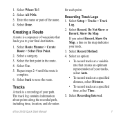
...All POIs. 3. Select a category. 3. The track log contains information about points along the recorded path, including time, location, and elevation
for each point. Select an option:
• To record tracks at a variable rate that leads you ...of waypoints that creates an optimum representation of your track.
3.
1. eTrex 20/30 Quick Start Manual
7 Select Record Method.
4.
Quick Start Manual - Page 8

... Often interval provides the most track detail, but fills up the device memory quicker. • Enter a time or distance, and select Done. Navigating to a Destination
You can navigate to move with the Bearing Pointer The eTrex 30 has a 3-axis, electronic compass.
8
eTrex 20/30 Quick Start Manual Select Where To?. 2. Using the Map
1.
6. As...
Quick Start Manual - Page 9

...device. Go to the destination. Select Compass.
3. Sign in My Computer on Windows
eTrex 20/30 Quick Start Manual
computers and as mounted volumes on -screen instructions
to find ... .
1. Reinstall the batteries (page 3). Connecting to a destination (page 8).
2. Your device and memory card (optional) appear as removable drives in . 5. Begin navigation to a Computer
1. Follow the ...
Quick Start Manual - Page 10
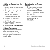
... the USA, call (913) 397.8200 or (800) 800.1020.
• In the UK, call 0808 2380000.
• In Europe, call +44 (0) 870.8501241.
10
eTrex 20/30 Quick Start Manual Open the "Garmin" drive or volume.
5. Pull up the weather cap from the Device 1.
Getting the Manuals from the mini-USB port.
3.
Similar Questions

How Can I Download A Gpsx File (track) Onto My Garmin Etrex 20 Device
Have recently bought an etrex 20 GPS (Live in New Zealand) and would like to down load the "Te Araro...
Have recently bought an etrex 20 GPS (Live in New Zealand) and would like to down load the "Te Araro...
(Posted by helenosephius 8 years ago)

Does My Garmin Etrex 20 Search For Geocaches Closest To My Current Location?
(Posted by NoorAkiddne 10 years ago)


