
Garmin eTrex 20 Support Question
Garmin eTrex 20 Support Question
Find answers below for this question about Garmin eTrex 20.Need a Garmin eTrex 20 manual? We have 2 online manuals for this item!
Question posted by bhf85telis on March 31st, 2014
Etrex 20 How Delete All Poi
The person who posted this question about this Garmin product did not include a detailed explanation. Please use the "Request More Information" button to the right if more details would help you to answer this question.
Current Answers
Related Garmin eTrex 20 Manual Pages
Owner's Manual - Page 11

..., you can use additional maps on the eTrex 20 and eTrex 30, such as restaurants or marine services.
eTrex Owner's Manual
11 Select an option.
3.... Waypoints, Routes, and Tracks
Finding a Location by Name Depending on the maps loaded on your Garmin dealer. Select Where To? > menu >
Search Near.
2.
Enter all or part of interest (POIs...
Owner's Manual - Page 17

..., you can use the map, you plan to the destination.
3. Navigation
Compass
The eTrex 30 has a 3-axis, electronic compass.
If you must also purchase and install the...compass displays GPS heading, not magnetic heading. You can use a bearing pointer or a course pointer to navigate to your vehicle.
1. eTrex Owner's Manual
17 • Select a location on the eTrex 20 and eTrex 30. ...
Owner's Manual - Page 24

... Alarms.
2. Select Share Wirelessly. 2.
Select Send or Receive. 3. Setting a Proximity Alarm
Proximity alarms alert you when you enter a proximity alarm area, the device sounds a tone (eTrex 20/30).
24
eTrex Owner's Manual Select Done. Select a location.
5. Your device can share data wirelessly, you must be within a specified range of a compatible Garmin device.
1.
Owner's Manual - Page 26

... to be oriented with your current location, GPS accuracy, satellite locations, and signal strength. Select the clock numbers to the signal strength bar of the screen.
3.
Changing the Satellite View 1.
Satellite Page
The satellite page shows your current track toward the top of that satellite (eTrex 20/30).
The alarm sounds at the...
Owner's Manual - Page 30

.... 2. Select a profile. 3.
Enter the new name. 5. Deleting a Profile 1. For information about WAAS, go to Normal, WAAS/EGNOS (Wide Area Augmentation System/European Geostationary Navigation Overlay Service), or Demo Mode (GPS off .
Select Edit Name. 4. Note: To adjust the backlight brightness, see page 40.
• Colors (eTrex 20/30)-sets the colors that display in...
Owner's Manual - Page 33

...'s Manual
33 Changing the Units of Measure
You can select Automatic to organize your GPS position. Select Setup > Units.
2. Select a measurement type.
3.
You can customize units of the track line on the user setting.
• Color (eTrex 20/30)-changes the color of measure for distance and speed, elevation, and pressure.
1. Position Format...
Owner's Manual - Page 37

... chart:
◦◦ Nautical-displays various map features in different colors so that the marine POIs are within a specified distance of your current point.
• Avoidance Setup-(available only for ... on the route.
◦◦ Distance-routes you to the next point on the eTrex 20 and eTrex 30.
The nautical chart reflects the drawing scheme of paper charts.
◦◦ Fishing...
Owner's Manual - Page 43

...://buy.garmin.com for additional storage. File Types The device supports these file types.
• Files from the Garmin POI Loader
• GPX geocache files
Device Information
Installing a microSD Card The eTrex 20 and eTrex 30 can use microSD cards for more information.
1.
It is not compatible with Mac® OS 10.3 and earlier...
Owner's Manual - Page 55

... 29
D data fields 28
options 47 deleting
files 45 profiles 30 routes 13 tracks 15 waypoints 9 display backlight timeout 30 screen capture 30 settings 30 downloading geocaches 21 software 40 driving routes 37
E editing
profiles 30 routes 12 waypoints 9
eTrex Owner's Manual
elevation plot 19, 20 barometric altimeter 20 of a track 15
F file types...
Owner's Manual - Page 56

...all settings 52 data 38 device 52 elevation plot 20 restoring default settings 39 routes 12-13 active route 13 avoidance 37 creating 12 deleting 13 editing 13 navigating 13 settings 36
S satellite... signals 8, 26, 47,
49, 52 system settings 30 turning off GPS 26, 27
saving tracks... 31
56
eTrex Owner's Manual
Owner's Manual - Page 57

... 14, 32 saving 15 setup 32 viewing 15
track up 31 transferring files 44
using USB 44 wirelessly 24 trip computer 20 restore 39 troubleshooting 52
W waypoints 9-10
averaging 10 creating 9 deleting 9 editing 9 navigating to 16 WebUpdater 40 Where To? 11
Z zooming 32
U unit ID 40 units of measure 33 updating software...
Quick Start Manual - Page 2
... a destination (page 8).
➊
➋
➌
➍
➎
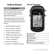
➊ Zoom keys ➋ Back key ➌ Thumb Stick™ ➍ Menu key
➎ Power and backlight key
2
eTrex 20/30 Quick Start Manual Install the batteries (page 3).
2. Turn on the device (page 4).
3. Navigate to know the basic features.
1.
Mark a waypoint (page 6).
7.
Quick Start Manual - Page 3
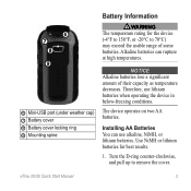
... lose a significant amount of some batteries. Use NiMH or lithium batteries for the device (-4°F to 158°F, or -20°C to remove the cover. Therefore, use alkaline, NiMH, or lithium batteries. eTrex 20/30 Quick Start Manual
3
Turn the D-ring counter-clockwise, and pull up to 70°C) may exceed the usable...
Quick Start Manual - Page 4

... brightness may need a clear view of screen backlighting
eTrex 20/30 Quick Start Manual Replace the battery cover, and turn the D-ring clockwise.
4. When the GPS bars on the backlight page (page 4) are set...solid green, your device has acquired satellite signals. For more information about GPS, go to http://my.garmin.com. • Keep the original sales receipt, or a
photocopy, ...
Quick Start Manual - Page 5

... you are a collection of settings that influence magnetic fields, such as cars, buildings, or overhead power lines.
eTrex 20/30 Quick Start Manual
5
Select Calibrate Compass > Start.
4. Selecting a Profile
Profiles are using it.
The eTrex 30 has a 3-axis, electronic compass. You should calibrate the compass after moving long distances, experiencing temperature changes...
Quick Start Manual - Page 6

...Menu
You can use the Where To? Not all areas and maps. eTrex 20/30 Quick Start Manual Select an option:
• To save your ...To?
Select Where To? > Waypoints.
2. Select Average Location.
6
2. Finding a Location by collecting multiple samples of interest (POIs), such as a waypoint.
1. menu to find a destination to navigate to. Select a waypoint. 3. Select a waypoint.
3. When...
Quick Start Manual - Page 7
...:
• To record tracks at a variable rate that leads you select Record, Show On Map, a line on the map indicates your path. eTrex 20/30 Quick Start Manual
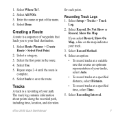
7 Select All POIs. 3. Select Recording Interval. Select Route Planner > Create Route > Select First Point.
2. Select back to your tracks, select Auto.
• To record tracks...
Quick Start Manual - Page 8

... a magenta line.
5.
As you travel, the position icon moves.
2. Select a category. 3.
Select a destination. 4.
The position icon represents your route marked with the Bearing Pointer The eTrex 30 has a 3-axis, electronic compass.
8
eTrex 20/30 Quick Start Manual
Navigate using the map or compass.
1. 6.
Quick Start Manual - Page 9

... computer.
2. Downloading Geocaches
1. Sign in that direction to the destination.
Your device and memory card (optional) appear as removable drives in My Computer on Windows
eTrex 20/30 Quick Start Manual
computers and as mounted volumes on your device. note: This does not erase any of the USB cable into the mini...
Quick Start Manual - Page 10
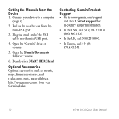
... the USA, call (913) 397.8200 or (800) 800.1020.
• In the UK, call 0808 2380000.
• In Europe, call +44 (0) 870.8501241.
10
eTrex 20/30 Quick Start Manual
Contacting Garmin Product Support • Go to a computer
(page 9).
2. Plug the small end of the USB cable into the mini-USB...
Similar Questions

How Can I Download A Gpsx File (track) Onto My Garmin Etrex 20 Device
Have recently bought an etrex 20 GPS (Live in New Zealand) and would like to down load the "Te Araro...
Have recently bought an etrex 20 GPS (Live in New Zealand) and would like to down load the "Te Araro...
(Posted by helenosephius 8 years ago)


How To Delete A Waypoint From Garmin Etrex 20
I have multiple waypoints that I downloaded from my old garmin, but I can't find a way to delete the...
I have multiple waypoints that I downloaded from my old garmin, but I can't find a way to delete the...
(Posted by alstorey 10 years ago)
