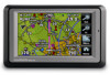
Garmin aera 500 Support Question
Garmin aera 500 Support Question
Find answers below for this question about Garmin aera 500.Need a Garmin aera 500 manual? We have 10 online manuals for this item!
Question posted by jecconsuegra on July 14th, 2012
Altimeter Setting
How can I select the altimeter setting in an aera 500 ?
Current Answers
Related Garmin aera 500 Manual Pages
Automotive Owner's Manual - Page 9
... and navigate to select automobile or aviation
mode.
➍ Battery status. ➎ Current time.
aera 500 Series Owner's Manual
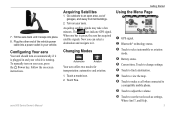
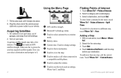
Acquiring Satellites
1. 7. Getting Started
Using the Menu Page
➏
➐
➑➒ ➓
➊ GPS signal. ➋ Bluetooth® technology status. ➌ Touch to it snaps into a power outlet in and your aera, press the...
Automotive Owner's Manual - Page 34
... need this information when you want to calculate routes that use less fuel than the other routes.
28
aera 500 Series Owner's Manual
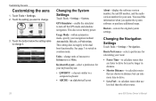
Changing the System Settings
Touch Tools > Settings > System. Route Preference-select a preference for your aera.
Usage Mode-within automotive mode, specify your route:
• Faster Time-to calculate routes that are faster to...
Automotive Quick Start Manual - Page 4
... GPS satellite strength. Touch to change settings. ➏ Touch to find a destination. ➐ Touch to view the map. ➑ Touch to make a call when connected to
a compatible mobile phone.
➒ Touch to adjust the volume. ➓ Touch to it snaps into a power outlet in your aera.
aera 500 series quick start manual Go outdoors to select...
Aviation Quick Reference Guide - Page 5
A
Garmin aera 500 Series Quick Reference Guide
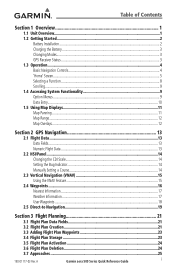
i Table of Contents
Section 1 Overview 1
1.1 Unit Overview...1 1.2 Getting Started...2
Battery Installation...2 Charging the Battery...3 Changing Modes...3 GPS Receiver Status...3 1.3 Operation...4 Basic Navigation Controls...4 'Home' Screen...5 Selecting a Function...8 Scrolling...9 1.4 Accessing System Functionality 9 Option Menus...9 Data ...
Aviation Quick Reference Guide - Page 14
...
Touch the desired icon. Sound
Displays sound settings.
The icon will momentarily turn blue when selected. A Hazard Avoidance Flight Planning
Utilities
Appendix
Index
Terrain Icon Selected ('Home' Screen)
8
Garmin aera 500 Series Quick Reference Guide
190-01117-03 Rev.
Alarms
Displays alarm settings.
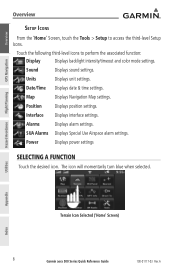
Overview
GPS Navigation
Overview
Setup Icons
From the 'Home...
Aviation Quick Reference Guide - Page 20
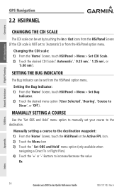
... the 'Home' Screen, touch HSI/Panel > Menu > Set Bug
Indicator. 2) Touch the desired menu option ('User Selected', 'Bearing', 'Course to increase/decrease the value
Or:
Utilities
Appendix
Index
14
Garmin aera 500 Series Quick Reference Guide
190-01117-03 Rev. Overview
GPS Navigation
Hazard Avoidance Flight Planning
GPS Navigation
2.2 HSI/Panel
Changing the CDI Scale
The...
Aviation Quick Reference Guide - Page 33
...
a) Touch the 'Set Up Map' menu option. a) Touch the 'Show/Hide...'
b) Touch the Terrain 'Show/Hide' Button to get abbreviated information about
the selected weather product (if available...
Overview
GPS Navigation
Flight Planning Hazard Avoidance
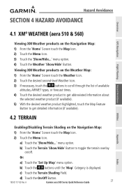
4.1 XM® Weather (aera 510 & 560)
Viewing XM Weather products on /off. c) Touch the Terrain Shading Field. A
Garmin aera 500 Series ...
Aviation Quick Reference Guide - Page 34
... aera 500 Series Quick Reference Guide
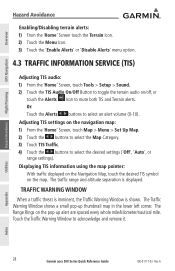
190-01117-03 Rev. Adjusting TIS settings on the navigation map: 1) From the 'Home' Screen, touch Map > Menu > Set Up Map. 2) Touch the buttons to select...desired TIS symbol on the pop-up thumbnail map in the lower left corner. Overview
GPS Navigation
Hazard Avoidance Flight Planning
Hazard Avoidance
Enabling/Disabling terrain alerts: 1) From the '...
Aviation Quick Reference Guide - Page 35
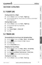
...Map > Menu > Set Up Map. 2) Touch the buttons to select the desired setting. Clearing the track log: 1) From the 'Home' Screen, touch Tools > Track Log. Overview
GPS Navigation
Flight Planning Hazard .... A
Garmin aera 500 Series Quick Reference Guide
29 Utilities
Appendix
Index
190-01117-03 Rev. Changing track log settings: 1) From the 'Home' Screen, touch Map > Menu > Set Up Map. ...
Aviation Quick Reference Guide - Page 36
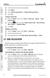
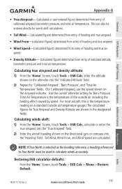
...Tools > E6B Calc. Use the current altimeter setting for True Airspeed and Density Altitude are ...aera 500 Series Quick Reference Guide
190-01117-03 Rev. Editing a track log: 1) From the 'Home' Screen, touch Tools > Track Log. 2) Touch the desired track log. 3) Touch desired field to select 'Entire Active Track', 'Past 24 Hours',
'Past 7 Days', or 'Specific Dates'. 3) Touch OK.
Overview
GPS...
Aviation Quick Reference Guide - Page 42
..., based upon current speed and track.
Estimated Time of climb or descent (GPS-derived).
A
Estimated Time En Route (Next)
The estimated time it takes to... or direct-to the previously selected VNAV position and altitude, based upon current ground speed. Sunset
The time at which the sun sets on this day (current location...aera 500 Series Quick Reference Guide
190-01117-03 Rev.
Aviation Quick Reference Guide - Page 43
... fields will be available. A
Garmin aera 500 Series Quick Reference Guide
37
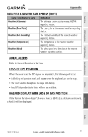
Loss of GPS Position
If the Terrain function doesn't have at the nearest METAR reporting station. Overview
GPS Navigation
Flight Planning Hazard Avoidance
Appendix
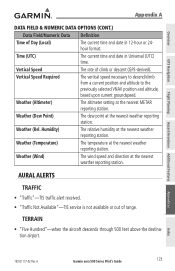
data Field & Numeric Data Options (Cont.)
Data Field/Numeric Data Definition
Weather (Altimeter)
The altimeter setting at least a 3D fix...
Pilot's Guide - Page 6
...altimeter when determining or selecting aircraft altitude. The Terrain Proximity feature is to be used in the aera system must NOT be updated regularly in the aircraft. WARNING: The altitude calculated by aera GPS... of the terrain data.
Garmin aera 500 Series Pilot's Guide
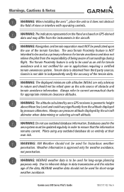
190-01117-02 Rev. Warnings, Cautions & Notes
WARNING: When installing the aera™, place the unit so ...
Pilot's Guide - Page 9
A
Garmin aera 500 Series Pilot's Guide
i Table of Contents
Section 1 Overview 1
1.1 Unit Overview...1 1.2 Getting Started...2
Battery Installation...2 Charging the Battery...3 Mounting the aera in the Aircraft 3 Turning the Unit On/Off...4 Changing Modes...4 GPS Receiver Status...5 1.3 Operation...7 Basic Navigation Controls...7 'Home' Screen...8 Selecting a Function...14 Scrolling...14 1.4 ...
Pilot's Guide - Page 31
...select locations on the map). Appendices
Index
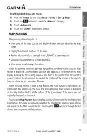
190-01117-02 Rev. Map Panning
Map panning allows the pilot to select... on the Map Feature Button. A
Garmin aera 500 Series Pilot's Guide
19 Touching the Map...
When the panning function is selected by touching anywhere on the ... selected airport, NAVAID or user waypoint
• Designate locations for the highlighted map feature. Overview
GPS ...
Pilot's Guide - Page 34
... > Set Up... level (-1, -2, -3) on the map. A
Index GPS Navigation
Additional Features Hazard Avoidance Flight Planning
Appendices
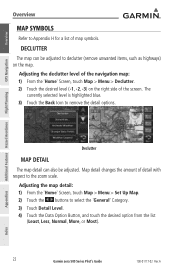
Declutter
Map...selected level is highlighted blue. 3) Touch the Back Icon to select the 'General' Category. 3) Touch Detail Level. 4) Touch the Data Option Button, and touch the desired option from the list
(Least, Less, Normal, More, or Most).
22
Garmin aera 500...
Pilot's Guide - Page 41
... Simulator Mode.
A
Garmin aera 500 Series Pilot's Guide
29
Appendices
Index
190-01117-02 Rev.
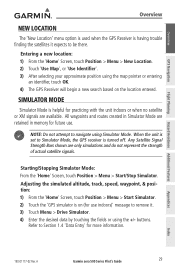
Entering a new location: 1) From the 'Home' Screen, touch Position > Menu > New Location. 2) Touch 'Use Map', or 'Use Identifier'. 3) After selecting your approximate position using the map pointer or entering
an identifier, touch OK. 4) The GPS Receiver will begin a new...
Pilot's Guide - Page 48

...Navigation Map.
A
Appendices
Index
36
Garmin aera 500 Series Pilot's Guide
190-01117-02 Rev. Overview
GPS Navigation
Additional Features Hazard Avoidance Flight Planning
GPS Navigation
Compass Arc
A compass arc appears by default on the HSI) can be set to 'Bearing' (default), 'Course to Steer', a specific heading reference ('User Selected'), or 'Off'. Magenta Bug Indicator
Compass...
Pilot's Guide - Page 135
...)
The altimeter setting at the nearest weather reporting station.
Appendices
Index
190-01117-02 Rev. A
Garmin aera 500 Series Pilot's Guide
123 Weather (Rel. Weather (Temperature)
The temperature at the nearest weather reporting station. Overview
GPS Navigation
Flight Planning Hazard Avoidance Additional Features
Appendix A
data Field & Numeric Data Options (Cont.)
Data...
Pilot's Guide - Page 173
...altimeter into the 'Indicated Altitude' field. 2) Repeat for Baro Pressure. NOTE: If True North is selected as the heading reference, a heading referenced to True North must be entered directly for True Airspeed and Density Altitude are calculated. A
Garmin aera 500 Series Pilot's Guide
161 Overview
GPS... designated fields. Use the current altimeter setting for 'Calibrated Airspeed', 'Baro ...
Similar Questions


Gps Aear 500 Driver
would you send a file for identification of Garmin Aera 500 please. this GPS need to identify with a...
would you send a file for identification of Garmin Aera 500 please. this GPS need to identify with a...
(Posted by kswesi 11 years ago)

Aera 500 Fuel Flow Question Does Not Display Units:
What units/hour are used? US gallons? Imperial gallons? Litres?
What units/hour are used? US gallons? Imperial gallons? Litres?
(Posted by firsttocall 11 years ago)
Reset Aera 500
hi! i have problem with my AERA 500. i Can´t start it. haw can i reset it? thank you
hi! i have problem with my AERA 500. i Can´t start it. haw can i reset it? thank you
(Posted by jacarrizo 12 years ago)