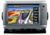
Garmin GPSMAP 740/740s Support Question
Garmin GPSMAP 740/740s Support Question
Find answers below for this question about Garmin GPSMAP 740/740s.Need a Garmin GPSMAP 740/740s manual? We have 7 online manuals for this item!
Question posted by Cbec61 on July 21st, 2013
Gps Location
I just purchased a garmin 740s and it will not obtain my current location
Current Answers
Answer #1: Posted by TommyKervz on July 21st, 2013 6:12 AM
TommyKervz

Member since:
January 10th, 2013 Points: 17,776,813

Member since:
January 10th, 2013 Points: 17,776,813
Greetings - Just in case you do not have these here
http://www.helpowl.com/manuals/Garmin/GPSMAP740740s/76390
http://www.helpowl.com/manuals/Garmin/GPSMAP740740s/76390
Related Garmin GPSMAP 740/740s Manual Pages
Technical Reference for Garmin NMEA 2000 Products - Page 2
... Taiwan or its subsidiaries, registered in any storage medium, for current updates and supplemental information concerning the use and operation of this manual or any person or organization of this and other countries. Garmin®, the Garmin logo, and GPSMAP® are trademarks of Garmin. or its products and to change or improve its subsidiaries...
Technical Reference for Garmin NMEA 2000 Products - Page 3
...for in-country support information, or contact Garmin (Europe) Ltd. This technical reference ...Garmin chartplotters and marine instruments as well as configuration and PGN information for the following products: ◦ GPSMAP® 4000/5000/6000/7000 Series chartplotters ◦ GPSMAP 700 Series chartplotters ◦ GPSMAP 4x1/5x1/5x6 Series chartplotters ◦ GMI™ 10 ◦ GPS...
XM Supplement - Page 2

... of Garmin Ltd.
Garmin®, the Gamin logo, GPSMAP®, BlueChart®, and g2 Vision® are registered trademarks of this manual or any storage medium, for current updates ...notice. Except as expressly provided herein, no part of this document is a trademark of Garmin. DAFIF™ is subject to change without obligation to make changes in any revision hereto ...
Installation Instructions - Page 1
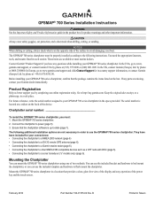
... of the device. You can mount the GPSMAP 700 series chartplotters using one of the surface to avoid damaging your convenience: • Connecting the chartplotter to a NMEA 2000 network (page 6) • Connecting the chartplotter to a GA 30 remote GPS antenna (page 6). • Connecting the chartplotter to a Garmin marine radar (page 6). • Connecting the chartplotter...
Installation Instructions - Page 2
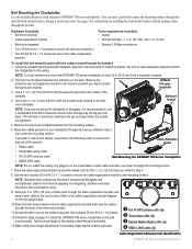
...).
➊ GA 30 GPS antenna cable clip ➋ Power/data cable clip ➌ Garmin Marine Radar cable clip ➍ NMEA 2000 cable clip
Cable-Organization-Bracket Clip Identification
GPSMAP 700 Series Installation Instructions Be sure to install the bail-mount bracket. Remove the protective liner and apply the template to the location at least 32...
Installation Instructions - Page 6
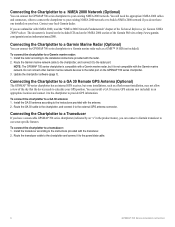
... GPS antenna (not included) in the product name), you are unfamiliar with the Garmin marine network.
If you can connect a Garmin transducer to use sonar-specific features. To connect the chartplotter to a transducer: 1. Connecting the Chartplotter to a Transducer
If you do not have a sonar-cable GPSMAP 700 series chartplotter (indicated by an "s" in an appropriate location...
Installation Instructions - Page 8
...
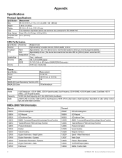
Specification Parameter
Receiver
Acquisition Time
Warm Cold
Reacquisition
Update Rate
Accuracy
GPS
DGPS
Velocity
Measurement High-sensitivity 12 parallel channel, WAAS-capable receiver Approximately 1 sec. (The device is at or near the last location at which you recently acquired satellites.) Approximately 38 sec. (The device has moved more than about 500 mi...
Owner's Manual - Page 2

... Corporation in any storage medium, for current updates and supplemental information concerning the use and operation of Garmin Ltd. © 2010 Garmin Ltd. Except as expressly provided herein,... and other Garmin products. or its subsidiaries.
Garmin®, the Garmin logo, GPSMAP®, BlueChart®, g2 Vision®, and MapSource® are registered trademarks of Garmin Ltd. These...
Owner's Manual - Page 4
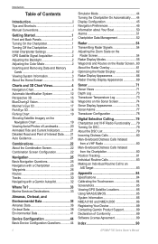
...Off the Chartplotter 1 Initial Chartplotter Settings 2 GPS Satellite Signal Acquisition 2 Adjusting the Backlight ...15 BlueChart g2 Vision 16 Mariner's Eye 3D 17 Fish ... Tide and Current Indicators 21... a Garmin Autopilot 32
Where To 33 Marine Services...GPS Satellite Locations 85 Using WAAS/EGNOS 85 System Information 85 NMEA 0183 and NMEA 2000 86 Registering Your Device 89 Contacting Garmin...
Owner's Manual - Page 6
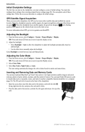
...collect satellite data and establish the current location. For more information about GPS, go to switch between Auto and Manual mode. Select Backlight to www.garmin.com/aboutGPS. TIP: Press and ... or the memory card into the slot again and release it to eject the card.
➊
2
GPSMAP 700 Series Owner's Manual From the Home screen, select Configure > System > Beeper/Display > Display....
Owner's Manual - Page 12
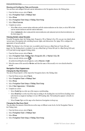
... 5. Select Navigation Chart Setup or Fishing Chart Setup.
8
GPSMAP 700 Series Owner's Manual
Select a navaid with the cursor...configure tide and current information on the screen. • Select Course Up to use GPS heading data.
...Currents. 6. Select Navigation Chart or Fishing Chart. 3. Viewing Details about Navaids From the Navigation chart, the Fishing chart, Perspective 3D, or Mariner...
Owner's Manual - Page 16
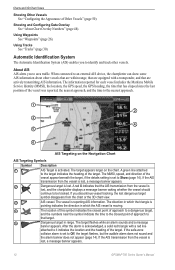
... area traffic. If you discontinue vessel tracking, the lost , a message banner appears.
12
GPSMAP 700 Series Owner's Manual If the AIS transmission from the vessel is lost, a message banner...information reported for each vessel includes the Maritime Mobile Service Identity (MMSI), the location, the GPS speed, the GPS heading, the time that the AIS transmission from the chart or the 3D ...
Owner's Manual - Page 18
You can view the AIS signal status, MMSI, GPS speed, GPS heading, and other information that is used for...alarm sounds when an AIS-activated vessel enters the safe-zone ring around your location within which AIS vessels appear. Note: The Mariner's Eye 3D chart is applied only to that chart or to a specified distance... radar modes, and to 2.0 mi.).
14
GPSMAP 700 Series Owner's Manual
Owner's Manual - Page 20
... Garmin GPS units or Garmin HomePort™. Select Perspective 3D or Mariner...'s Eye 3D. 3.
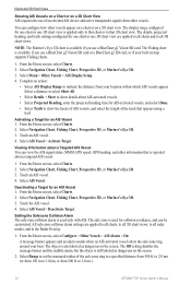
Selecting a Lane Width The navigation lane is on the Navigation chart.
• Aerial Photos (page 20)-shows marinas and other points of the land and water on or off.
16
GPSMAP 700 Series Owner's Manual The BlueChart g2 Vision Mariner...
Owner's Manual - Page 54

... averages the speed of Other Vessels Note: The Mariner's Eye 3D chart is not stuck. From the Home screen, select Configure > System > GPS. 2.
Select Menu > Other Vessels > AIS Display...Select Speed Filter > Auto to allow the unit to get the message, contact Garmin Product Support.
50
GPSMAP 700 Series Owner's Manual Note: To configure Automatic Identification System (AIS) information...
Owner's Manual - Page 56
...current version by clicking Help > Check for Software Updates.
1. Enter the GPS location accuracy that triggers the alarm. 3. From the Home screen, select Configure > Alarms > Fuel > Total Fuel Onboard > On. 2.
If the software version is older than 6.12.2, update to sound when the GPS location... chartplotter.
4. Setting Weather Alarms See the GPSMAP 700 Series XM WX Satellite Weather® and...
Owner's Manual - Page 75
... and unit voltage
➌ Suspended target
➍ Bottom
➎ Range
➏ GPS speed and GPS heading
➐ Transducer frequency
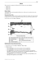
Setting the Zoom Level on the Full-screen View You ...of the screen shows the depth of detected objects as fishfinders: • GPSMAP 720s • GPSMAP 740s • GPSMAP 750s
Sonar Views
The chartplotter shows sonar data using three different views: ...
Owner's Manual - Page 88

...
Specification Parameter
Receiver
Acquisition Time
Warm
Cold
Update Rate Accuracy
Velocity
Reacquisition
GPS DGPS
Measurement High-sensitivity 12 parallel channel, WAAS-capable receiver Approximately 1 sec. (The device is at or near the last location at which you recently acquired satellites.) Approximately 38 sec. (The device has moved more than about 500 mi...
Owner's Manual - Page 89
...log shows a list of any location on your chartplotter, and transfer the file to a memory card as a bitmap (.BMP) file a screenshot of system events. GPSMAP 700 Series Owner's Manual
85... Garmin Product Support representative may ask you want to Card. 3. From the Home screen, select Configure > System > GPS > Skyview. From Windows Explorer, open the Garmin\scrn folder on the front of GPS ...
Owner's Manual - Page 94
...12, 14, 58 deep water 77 fish 77 GPS accuracy 52 navigation 51 off course 51 shallow water...photos 11 chart symbols 5 data cards 16 Fish Eye 3D 18 Mariner's Eye 3D 17 POIs 21
bridging, output 88 brightness, display ... 74, 81 cross talk 63, 66 cruising mode 55 current station indicators, configuring 8 current stations indicators 8, 21 nearby 37 reports 37
D dangerous ...GPSMAP 700 Series Owner's Manual
Similar Questions

Gps 740s
Entered Waypoints Are Not Right Tryed Several Numbers Still Wont Find A Spot Had A 441s Used Same Nu...
Entered Waypoints Are Not Right Tryed Several Numbers Still Wont Find A Spot Had A 441s Used Same Nu...
(Posted by CANES61662 9 years ago)


Garmin Gps 172c Will Not Locate Satellites
(Posted by kapatgamus 10 years ago)
How To Change Engine Screen On My Garmin 740 Gps
(Posted by diandy 10 years ago)

My New Gpsmap 740 Displays Inaccurate Gps Heading Information. Cause?
(Posted by Kirkehasson 11 years ago)