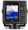
Garmin GPSMAP 547xs Support Question
Garmin GPSMAP 547xs Support Question
Find answers below for this question about Garmin GPSMAP 547xs.Need a Garmin GPSMAP 547xs manual? We have 10 online manuals for this item!
Question posted by blaketimothy on February 8th, 2015
More Nav Detail For Garmin 547xs
Hello, I bought the 547 xs last summer. I was hoping for more navigational detail since it claimed to come with marine charts.. Is there a chip or somehting i can add to it to make it more detailed.. Many pints, bays, islands..etc.. are not showing that are clearly labeled on other models of GPS. I am in Alaska. Tim Blake
Current Answers
Answer #1: Posted by TommyKervz on February 9th, 2015 7:31 PM
TommyKervz

Member since:
January 10th, 2013 Points: 17,776,783

Member since:
January 10th, 2013 Points: 17,776,783
Download and install the latest software here http://www8.garmin.com/support/download_details.jsp?id=8743#Instruct
Related Garmin GPSMAP 547xs Manual Pages
Important Safety and Product Information - Page 2
... not remove or attempt to mariners contain all data sources contain ... combination of authorized government charts. After submersion, be certain to www.garmin.com/compliance.
Category II...navigating. • When navigating, carefully compare information displayed
on the unit to all available navigation... government charts and notices to remove the non-user- Battery Warnings Your GPS unit...
Important Safety and Product Information - Page 4
...marins contiennent toutes les informations nécessaires à une navigation en toute sécurité.
• L'appareil doit être utilisé uniquement comme une aide à la navigation.
Garmin...terms and conditions. Go to www.garmin.com/ support/warranty.html for more details and to a replacement or refund ... goods come with a new or newly-overhauled replacement product) the ...
Chartplotter Configuration Guide for Mercury Zeus and Axius Systems - Page 1
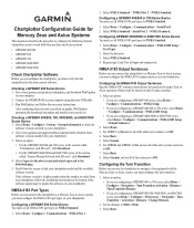
...the GPSMAP 400/500 and 700 series, in the section called "Chartplotters with SD card", click Download.
• For the GPSMAP 4000/5000 and 6000/7000 series, in the section called "Garmin Marine ... Communications > NMEA Port 1.
2. Configuring the Turn Transition
Before you can use the chartplotter to navigate a boat equipped with the Mercury Zeus or Axius system, you must verify that you want to...
Declaration of Conformity - Page 1
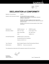
.... Methods of Equipment: Model Number(s):
Marine Navigation Equipment (Global Positioning System Receiver) GPSMAP 5x6 (X may be any numeral 0-9)...navigation and radio communication equipment and systems. General Requirements. General requirements
Manufactured by: Manufacture's Address:
Authorised Representative:
GARMIN International & 1200 E. 151st Street Olathe, Kansas 66062 U.S.A
GARMIN...
Installation Instructions - Page 3
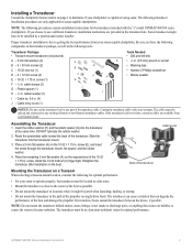
... (A) on the exposed end of the transducer cable.
GPSMAP 400/500 Series Installation Instructions
3 Installing a Transducer
Consult the chartplotter feature matrix on page 1 to determine if your Garmin dealer.
cable clamps (2) G - Plastic spacer (1) H - 1/4 in . The cable cannot be installed by a professional marine installer. Assembling the Transducer
1. screw (E), and insert...
Installation Instructions - Page 8
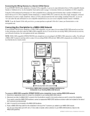
...Garmin dealer, or visit www.garmin.com. Connecting the Chartplotter to a NMEA 2000 Network
If your GPSMAP 400/500 series chartplotter is NMEA 2000-compatible, you must purchase an optional CANet Kit. See www.garmin.com for more cable is needed, add... the side of a NMEA 2000 T-connector from your local Garmin dealer or marine dealer.
You can on page 1 to determine whether your ...
Owner's Manual - Page 4
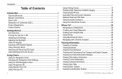
... Home Screen 6
Using Charts 7 Using the Navigation Chart 7 Changing the Navigation Chart Settings 11 Using the Split Navigation Chart 14 Using Perspective 3D 14 Using Mariner's Eye 3D 15 Using Fish Eye 3D 17
ii
Using Fishing Charts 17 Enabling High Resolution Satellite Imagery 18 Viewing Aerial Photos 19 Animated Tide and Current Indicators 20 Detailed Road and POI Data...
Owner's Manual - Page 11
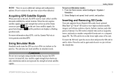
... Warning Do not try to navigate using simulator mode, because the GPS receiver is on Simulator mode: 1. From the Home screen, select Configure > System >
Simulator. 2. GPSMAP 400/500 Series Owner's Manual...bars disappear and the position icon displays a flashing question mark. Select Setup to another compatible Garmin unit or a computer (page 40). Use SD cards to transfer data such as waypoints...
Owner's Manual - Page 13
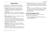
..., in map supports Fishing charts.
• Fishing Chart-provides a view of the Navigation chart at the same time.
Mariner's Eye 3D charts and Fish Eye 3D charts are using a GPSMAP 421, 521, or 526 (including "s" models), you must insert an optional BlueChart g2 Vision preprogrammed SD card to view detailed Navigation and Mariner's Eye charts. Using Charts
• Mariner's Eye 3D-provides...
Owner's Manual - Page 34
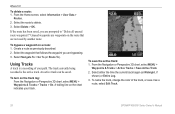
... Active Track.
2. Select Delete > OK.
Create a route as a route, select Edit Track.
28
GPSMAP 400/500 Series Owner's Manual
To bypass a waypoint on the track log: From the Navigation or Perspective 3D chart, select MENU > Waypoints & Tracks > Tracks > On. Select Navigate To > Go To (or Route To).
Select the waypoint that are bypassing. 3. The...
Owner's Manual - Page 35

... from
your course. This setting is recorded.
To retrace the active track: 1. From the Navigation or Perspective 3D chart, select MENU >
Waypoints & Tracks > Active Tracks > Follow Active Track. 2. GPSMAP 400/500 Series Owner's Manual
29
From the Navigation or Perspective 3D chart, select MENU >
Waypoints & Tracks > Saved Tracks. 2. The current track continues to delete the...
Owner's Manual - Page 36
...yourself on the Navigation chart.
• Aerial Photos-provides a view of your unit. Note: You cannot transfer BlueChart g2 Vision data from static electricity. GPSMAP 400/500 Series ...the information on BlueChart g2 Vision-compatible Garmin GPS units.
In addition to detailed marine charting, BlueChart g2 Vision has the following features:
• Mariner's Eye 3D-provides a view from ...
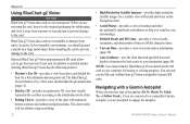
Owner's Manual - Page 56
... toggle between water (from a water-speed sensor) and GPS (from shore: 1.
To set the minimum depth (chart depth datum) to
previously.
5. From Home screen, select Where To? > Waypoints. 4. Review the placement of a bridge that the auto-guidance line is hidden. Configuring the Chartplotter
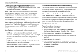
Configuring Navigation Preferences
To change this determines whether route turns...
Owner's Manual - Page 80

... fish 54 fuel 54 GPS accuracy 54 navigation 53 off course 53 safe...Chart Borders 13 chart data 9 charts
detail 12 fish eye 3D 17 fishing 17
mariner's eye 3D 15 navigation 7 settings 11 Clear User Data 39 collision alarm 56 colors, hazard 16 Color Scheme 61 Communications 51 Compass 31 compass rose 12 Compass Tape 9 contact information, Garmin...GPSMAP 400/500 Series Owner's Manual
Owner's Manual - Page 81
... datum 49 MapSource data 39 mariner's eye 3D 15
colors 16 mark current location 25 measuring distance 26 MENU key 5 messages 69 move a waypoint 25 My Boat 55
N
Navaid Size 13
GPSMAP 400/500 Series Owner's Manual
Navaid Type 13 Navigate To 10, 24, 26, 27, 65 Navigation Alarms 53 navigation charts 7 navigation preferences 50 New Waypoint...
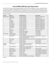
Technical Reference for Garmin NMEA 2000 Products - Page 3

... click Contact Support for Garmin NMEA 2000 Products
iii These sections contain PGN and configuration information for the following products: ◦◦ GPSMAP® 4000/5000/6000/7000 Series chartplotters ◦◦ GPSMAP 700 Series chartplotters ◦◦ GPSMAP 4x1/5x1/5x6 Series chartplotters ◦◦ GMI™ 10 ◦◦ GPS 17x ◦◦...
Technical Reference for Garmin NMEA 2000 Products - Page 13
...
Waypoint Name Bearing to Waypoint Distance to the NMEA 2000-certified display devices (such as a GPSMAP 4000/5000 series chartplotter or a GMI 10) on the NMEA 2000 network. Eng Dynamic 127488 - Nav Data, 129285 - Nav Data 127250 - Eng Dynamic (GPS Speed or Water Speed) Note: The Fuel Economy data type is necessary or a specific...
Technical Reference for Garmin NMEA 2000 Products - Page 14

...Nav Data
Garmin Chartplotter and GPS Antenna
129026 - GNSS Position GPS Antenna
129026 - COG/SOG and 129029 - COG/SOG and 129029 - Envir Param Old, Barometric Pressure Sensor or 130311 - Vessel Heading, and 128259 - GNSS Position])
(If a GPS...Category Navigation Information (continued)
Trip
Weather
Data Type GPS Speed
Position Turn
Odometer Trip Odometer Average GPS Speed Maximum GPS Speed...
Technical Reference for Garmin NMEA 2000 Products - Page 15

... present, a less-accurate reading can be calculated using only the Wind Sensor, Water Speed Sensor, and Heading Sensor [130306 - COG/SOG and 129029 - Nav Data
Garmin Chartplotter and GPS Antenna
Maximum Apparent Wind Speed 130306 - Water Speed (If a Water Speed Sensor is not present, a less-accurate reading can be calculated using only the...
Weather Supplement - Page 2

...make changes in the content of this product. These trademarks may not be used without the written consent of Garmin. or its subsidiaries, registered in part, without the express permission of Garmin. Garmin...and other countries.
© 2011 Garmin Ltd. DAFIF™ is a trademark of XM Satellite Radio Inc. Garmin®, the Gamin logo, GPSMAP®, BlueChart®, GDL®, ...
Similar Questions

Garmin Gpsmap 492 How To Set The Gps Accuracy Alarm In A 429gpsmap.
I have Garmin gpsmap 492 chartplotter and I can't find the system sub tab to adjust the GPS Accuracy...
I have Garmin gpsmap 492 chartplotter and I can't find the system sub tab to adjust the GPS Accuracy...
(Posted by bamajo2 8 years ago)

What Is The Difference Between Garmin Gpsmap 172 And 172 Gps Receiver
(Posted by nbkqReg 10 years ago)

How I Can Change From Meters To Feet To A Gpsmap 541s Marine?
(Posted by dvazquezpr 11 years ago)

My New Gpsmap 740 Displays Inaccurate Gps Heading Information. Cause?
(Posted by Kirkehasson 11 years ago)

The Gps Will Not Pick Up The Satelite Signals.
I reinstalled the Garmin GPSMAP 292 after the winter break only to find out it will not pick up the ...
I reinstalled the Garmin GPSMAP 292 after the winter break only to find out it will not pick up the ...
(Posted by larsburmeister 12 years ago)