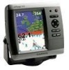
Garmin GPSMAP 545s Support Question
Garmin GPSMAP 545s Support Question
Find answers below for this question about Garmin GPSMAP 545s - Marine GPS Receiver.Need a Garmin GPSMAP 545s manual? We have 4 online manuals for this item!
Question posted by walterf5 on August 22nd, 2011
Remove Some Of The Trails That Are On My Screen
how can I get rid of some of the dotted trails that are left every time I use my navigation map
Current Answers
Related Garmin GPSMAP 545s Manual Pages
Quick Reference Guide - Page 1

...
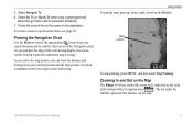
3. To stop navigating: From the navigation chart, press MENU, and select Stop Navigating.
Select Create Waypoint. Use the map pointer ( ) to It
To begin navigating: 1. Create a Waypoint
Editing or Deleting a Waypoint
To edit an existing waypoint: 1. OR From the Home screen, select Information > User Data > Waypoints. 2. Finding a Marine Service and Navigating to highlight the...
Quick Reference Guide - Page 2

... Zooming on the Rocker. Map pointer
As you select Use Chart, use the map pointer ( ) to other important information. Repeat this step to save the route. 6. From the Home screen, select Information > User Data > Routes. 2.
A trailing line on the map. Home Screen
Please visit www.garmin.com for product warnings and other areas on the Navigation chart.
MENU-Press...
Owner's Manual - Page 3
... following products:
GPSMAP® 430/430s GPSMAP 431/431s GPSMAP 530/530s GPSMAP 531/531s GPSMAP 540/540s GPSMAP 541/541s
GPSMAP 440/440s GPSMAP 441/441s GPSMAP 535/535s GPSMAP 536/536s GPSMAP 545/545s GPSMAP 546/546s
Tips and Shortcuts
• Press HOME from any screen to return to the Home screen.
• Press MENU from any of items on the screen using the Rocker, and...
Owner's Manual - Page 4
... GPS Satellite Signals 5 Using Simulator Mode 6 Viewing System Information 6 Restoring the Original Factory Settings 6 Inserting and Removing SD Cards 6 Understanding the Home Screen 7
Using Charts 8 Using the Navigation Chart 8 Changing the Navigation Chart Settings 12 Using the Split Navigation Chart 15 Using Perspective 3D 15
ii
Using Mariner's Eye 3D 16 Using Fish Eye 3D 18 Using...
Owner's Manual - Page 12
... the software version, the basemap version, supplemental map information (if applicable), the unit ID number, and your XM® WX Satellite Weather® Radio ID (if available). Restoring the Original Factory Settings
NOTICE: This procedure deletes any information you to navigate using simulator mode because the GPS receiver is located on Simulator mode: 1. Select Yes...
Owner's Manual - Page 15

... (page 55). Select Data Bar Setup to configure the position of the data on the screen.
• Navigation-turn the GPS Speed, GPS Heading, Depth, and GPS Position data bar on or off . Data Bars-show or hide cruising, navigation, fishing, fuel, or sailing numbers. Full Screen Map-view the Navigation or Fishing chart in fullscreen mode, without numbers.
Owner's Manual - Page 17
... your current location and to scroll to other areas on the map. Using Charts
To pan the map, press up, down, right, or left on the Map The Range (-/+) keys control the zoom level, indicated by the scale at the bottom of the Navigation chart ( ). GPSMAP 400/500 Series Owner's Manual 11
Follow the colored line on...
Owner's Manual - Page 18

... station to a compatible marine wind sensor.
12
GPSMAP 400/500 Series Owner's Manual Changing the Navigation Chart Settings
To change chart settings from the home screen, select Charts > Navigation Chart > MENU > Chart Setup.
True wind or apparent wind direction displays if the unit is only available while using a BlueChart g2 Vision SD card. Use the map pointer ( ) to...
Owner's Manual - Page 21
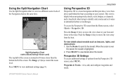
... the Perspective 3D screen from the Perspective 3D screen, select MENU. GPSMAP 400/500 Series Owner's Manual 15
Press the Range (-) key to the navaid. Split Navigation Chart (with a BlueChart g2 Vision card)
The top half of the Navigation chart at the same time. Waypoints & Tracks-view, add, and configure waypoints and tracks.
Use the Rocker to...
Owner's Manual - Page 23

...temporarily appears at the bottom of the Mariner's Eye 3D screen, select MENU > Chart Appearance.
Using Charts
Style-Selects how chart data is ... Mariner's Eye 3D (Water Hazard Colors) GPSMAP 400/500 Series Owner's Manual 17 To view details about the navaid. Mariner's...Mariner's Eye 3D screen, press MENU. Press the Range (-) key to Waypoints & Tracks, Other Vessels, and Data Bars, see "Navigation...
Owner's Manual - Page 31
...signal status, MMSI, GPS speed, GPS heading, and other information that appears using a trail, or turn the trail off. Select Navigation Chart, Fishing Chart, Perspective 3D, or
Mariner's Eye 3D. 3.
Select Navigation Chart, Fishing Chart, Perspective 3D, or
Mariner's Eye 3D. 3. Select Navigation Chart, Fishing Chart, Perspective 3D, or Mariner's Eye 3D.
3. From the Home screen, select Charts...
Owner's Manual - Page 35

....
• Right or Left Arrow-switches between waypoint information and the Navigation chart. To view a list of all waypoints: From the Home screen, select Information > User ...for each waypoint. From the Home screen, select Charts > Navigation Chart. 2. To move .
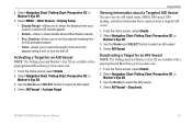
From the Navigation chart, use the map pointer ( ) to 1,500 waypoints (3,000 waypoints for models GPSMAP 431/441/531/541/536/546...
Owner's Manual - Page 36

...GPSMAP 400/500 Series Owner's Manual Press SELECT.
Select Use Chart or Use Waypoint List.
3. If you select Use Waypoint List, select the first waypoint on the Navigation chart. From the Navigation chart, use the map...From the Navigation chart, use the map pointer ( ) to add additional turns.
5. Repeat this step to select
your present location: 1. From the Home screen, select Information...
Owner's Manual - Page 48
..., from the Home screen, select Configure > Preferences > Navigation.
Turn Transition-set the time zone you are using a map or chart that specifies a different position format.
Route Labels-for the Time Zone, the DST option is not available and is automatically set the magnetic variation value.
Configuring the Chartplotter
Note: You must be receiving NMEA sonar depth data...
Owner's Manual - Page 56
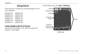
... the Home screen, select Sonar > Full Screen. Using Sonar
Using Sonar
When connected to a transducer, the following chartplotters can be used as fishfinders:
GPSMAP 430s GPSMAP 431s GPSMAP 530s GPSMAP 531s GPSMAP 540s GPSMAP 541s
GPSMAP 440s GPSMAP 441s GPSMAP 535s GPSMAP 536s GPSMAP 545s GPSMAP 546s
Understanding the Full Screen
Select the Full Screen option to view a full-screen graph of...
Owner's Manual - Page 59
... in white.
While viewing a sonar screen, press MENU > Pause Sonar. 2. Use the Rocker to position the pointer over...-stops the scrolling of each symbol is capable), cruising, and navigation. No background information appears. To mark a waypoint at a ...no background information shown. GPSMAP 400/500 Series Owner's Manual
Using Sonar
• Whiteline-highlights the strongest signal...
Owner's Manual - Page 63
...Trail to show or hide the trail line for at the position sent with the distress call.
57 Every position report call received is also available with the radio to delete the call report. GPSMAP 400/500 Series Owner's Manual
Using... radio, your Garmin chartplotter displays the man-overboard screen and prompts you to navigate to a VHF radio using a Garmin NMEA 2000‑compatible VHF radio.
...
Owner's Manual - Page 73

From the Home screen, select Information > Weather > Visibility. Select Next again to select Next. Using XM WX Weather and Audio
Viewing Visibility Information
Visibility is... forecasts for the next 24 and 36 hours. Press right on the left of the red arrow. The forecasted visibility
for another time period: 1. GPSMAP 400/500 Series Owner's Manual 67
To view the forecasted visibility for ...
Owner's Manual - Page 75
..., 320 × 234 pixels. GPSMAP 535/536/545/546: 5.0 in .
GPSMAP 536/536s GPSMAP 546/546s
Update Rate: once per second
GPSMAP 400/500 Series Owner's Manual 69 GPSMAP 530/531/540/541: 5.0 in .
GPSMAP 430/430s GPSMAP 530/530s GPSMAP 540/540s
GPSMAP 440/440s GPSMAP 535/535s GPSMAP 545/545s
High-sensitivity, 14 parallel channel, WAAS-capable receiver. Case: Fully gasketed, high-impact...
Owner's Manual - Page 76
GPS Accuracy: Position:
Appendix
Acquisition Times: (Average acquisition times for a stationary receiver with a clear view of the sky.) GPSMAP 430/430s GPSMAP 440/440s GPSMAP 530/530s GPSMAP 535/535s GPSMAP 530/540s GPSMAP 535/545s
Warm:* Approximately 15 seconds Cold:** Approximately 45 seconds
GPSMAP 431/431s GPSMAP 441/441s GPSMAP 531/531s GPSMAP 541/541s
Warm:* Approximately 1 second Cold:**...
Similar Questions

How Do I Go Into Simulation Mode On A Garmin Marine Gps Modle741xs
how do I use simulation mode on a garmin 741xs marine ver
how do I use simulation mode on a garmin 741xs marine ver
(Posted by Curthupp 6 years ago)

In Uk Where Repair Gps 172c Rom Failure
gps 172c was very slow to aquire sats; now every time power up map and gps steady but compass way of...
gps 172c was very slow to aquire sats; now every time power up map and gps steady but compass way of...
(Posted by davidriley100 11 years ago)

Getting The Navigational Chart With Navigational Data
I can't seem to get the standard navigational chart showing the navigation data on a line across the...
I can't seem to get the standard navigational chart showing the navigation data on a line across the...
(Posted by bkrause 11 years ago)

How To Remove White Screen Discoloration?
(looks Like Whitish Mildew, Rectangul
(Posted by hstibbs 11 years ago)

Is It Poss To Enter A Manuel Gps Heading To The Garmin Gpsmap545s
(Posted by marioh1228 13 years ago)