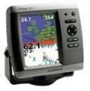
Garmin GPSMAP 545 Support Question
Garmin GPSMAP 545 Support Question
Find answers below for this question about Garmin GPSMAP 545 - Marine GPS Receiver.Need a Garmin GPSMAP 545 manual? We have 5 online manuals for this item!
Question posted by Captbobwoods on October 27th, 2012
Garmin 545 Locked Up
When i boot up garmin 545 screen locks with lost weather signal
Current Answers
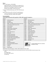
Related Garmin GPSMAP 545 Manual Pages
Declaration of Conformity - Page 1
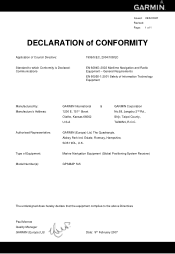
... Address:
Authorised Representative:
Type of Council Directive:
Standard to the above Directives
Paul Morrow Quality Manager GARMIN (Europe) Ltd
Date: 9th February 2007 GARMIN (Europe) Ltd, The Quadrangle, Abbey Park Ind. Marine Navigation Equipment (Global Positioning System Receiver)
GPSMAP 5x5
The undersigned does hereby declare that the equipment complies to which Conformity is Declared...
Installation Instructions - Page 3
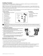
... included with the "s" model GPSMAP 400/500 series chartplotters. Cutting...Garmin) transducer cables. Cable tie slot
E G
Back of the transducer
Mounting the Transducer on a Transom When selecting a transom-mount location, consider the following tools:
Transducer Package • Transom-mount transducer (not pictured) A - 5 mm flat washers (2) B - 5 × 30 mm screws (2) C - 10-32 lock...
Installation Instructions - Page 8
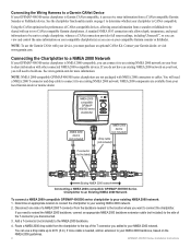
... or marine dealer. If you need a NMEA 2000 T-connector and drop cable to connect it can receive sonar information from a CANet-compatible Garmin Sounder or Fishfinder device. NOTE: To use a drop cable up to two CANet compatible Garmin chartplotters. Connecting the Chartplotter to a NMEA 2000 Network
If your GPSMAP 400/500 series chartplotter is needed...
Installation Instructions - Page 10

... channel WAAS-capable receiver
GPSMAP 421/431/441/451 (s) GPSMAP 521/531/541/551 (s): High-sensitivity 14 parallel channel WAAS-capable receiver.
Update Rate: 1/second, continuous
GPS Accuracy: Position: Return the boat to the speed at which this occurs.
2. If the signal strength improves while turning, adjust the transducer so that it was lost or the bottom...
Installation Instructions - Page 11
...GPSMAP 525s/526s/535s/536s/545s/546s/555s/556s units only.) Dual Frequency, 500 W (RMS), 4,000 W (peak to peak); Position Data Cross Track Error Navigation Data Navigation - Command/Request/Acknowledge Group Function Transmit/Receive... about National Marine Electronics Association (NMEA) format and sentences from: NMEA Seven Riggs Avenue Severna Park, MD 21146 USA www.nmea.org
GPSMAP 400/500 Series...
Quick Reference Guide - Page 2

...route, delete the route, or navigate to be recorded.
© 2009 Garmin Ltd. A trailing line on the Rocker. the current track continues to the...screen appears, select I Agree to edit.
3. Acquiring GPS Satellite Signals When you
want to
make the last turn list to manually adjust the backlight. Select Backlight. 3.
ROCKER-Press up or down , left or right on the unit, the GPS receiver...
Owner's Manual - Page 4
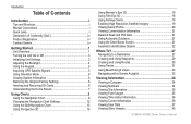
... Unit On or Off 3 Initializing Unit Settings 3 Adjusting the Backlight 4 Using the Keypad 5 Acquiring GPS Satellite Signals 5 Using Simulator Mode 6 Viewing System Information 6 Restoring the Original Factory Settings 6 Inserting and Removing SD Cards 6 Understanding the Home Screen 7
Using Charts 8 Using the Navigation Chart 8 Changing the Navigation Chart Settings 12 Using the Split...
Owner's Manual - Page 12
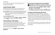
.... Using Simulator Mode
Simulator mode turns the GPS receiver off . Any satellite signal-strength bars shown are only simulations and do not represent the strength of interest. Select Setup to adjust unit settings (page 3). Getting Started
For more information about GPS, visit the Garmin Web site at www.garmin.com/aboutGPS. CAUTION: Do not try to...
Owner's Manual - Page 23

...Mariner's Eye 3D screen, select MENU > Chart Appearance.
The Off setting shows the land as beacons, lights, and obstructions: 1. Press the Range (+) key to move the view away from the boat. To view details about the navaid.
Mariner's Eye 3D (Water Hazard Colors) GPSMAP...very shallow water.
Use the Rocker to point to a weather module and you have an XM subscription.) See page 60...
Owner's Manual - Page 31
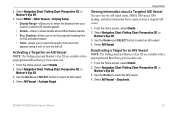
...Navigation Chart, Fishing Chart, Perspective 3D, or
Mariner's Eye 3D. 3. Select AIS Vessel. Use the Rocker to select an AIS vessel. 4. GPSMAP 400/500 Series Owner's Manual
25 2. From the Home screen, select Charts. 2. Select MENU > Other Vessels...Vessel You can view the AIS signal status, MMSI, GPS speed, GPS heading, and other information that appears using a trail, or turn the trail off.
Owner's Manual - Page 39
...a view of roads, restaurants, and other points of interest (POIs) along the shore. GPSMAP 400/500 Series Owner's Manual
33 This chart works well for offshore deep-sea fishing.
...Mariner's Eye 3D is more detailed than the preloaded data.
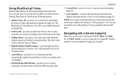
• Fish Eye 3D-provides an underwater 3D view that visually represents the sea floor according to the information on BlueChart g2 Vision-compatible Garmin GPS...
Owner's Manual - Page 52

...GPSMAP 400/500 Series Owner's Manual
Anchor Drag-set an alarm to sound when you have Activation set an alarm to sound when the battery reaches a specified low voltage. GPS Accuracy-set the distance before arrival that the alarm should sound.
Note: You must be receiving... screen, select Configure > Alarms > Sonar. Setting Sonar Alarms To set an alarm using a Garmin sounder...
Owner's Manual - Page 53
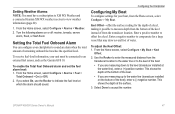
...Garmin GFS 10. From the Home screen, select Configure > Alarms > Weather. 2. To receive fuel-level information, your unit must have a subscription to XM WX Weather and a connected Garmin XM WX weather receiver to view weather information (page 60).
1.
Keel Offset-offset the surface reading for a keel.
GPSMAP... (transducer installed on or off: marine, tornado, severe
storm, flood, ...
Owner's Manual - Page 56
...Using Sonar
Using Sonar
When connected to a transducer, the following chartplotters can be used as fishfinders:
GPSMAP 430s GPSMAP 431s GPSMAP 530s GPSMAP 531s GPSMAP 540s GPSMAP 541s
GPSMAP 440s GPSMAP 441s GPSMAP 535s GPSMAP 536s GPSMAP 545s GPSMAP 546s
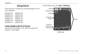
Understanding the Full Screen
Select the Full Screen option to view a full-screen graph of the
transducer's sonar readings. From the Home...
Owner's Manual - Page 58

... scrolls from right to the water speed of the screen.
52
GPSMAP 400/500 Series Owner's Manual The graph scrolls to...received.
To set the duration and the scale for the log.
Temp and depth
Time elapsed
Temperature range
Temp Log
The temperature appears along the right side, and the time elapsed appears along the right side of your boat.
Setting Up Sonar
Use the Sonar Setup screen...
Owner's Manual - Page 61
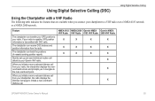
... chartplotter can track the positions of vessels sending position reports.
NMEA 0183 NMEA 2000 Garmin NMEA Garmin NMEA VHF Radio VHF Radio 0183 VHF Radio 2000 VHF Radio
X
X
X
X
X
X
X
X
X
X
X
X
X
X
X
GPSMAP 400/500 Series Owner's Manual
55 The chartplotter can receive DSC distress and position information from your chartplotter, the radio displays the Distress Call page...
Owner's Manual - Page 67
... visible on a Perspective 3D chart or a Mariner's Eye 3D chart:
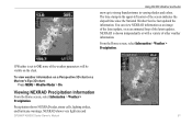
Press MENU > Weather Radar > On. From the Home screen, select Information > Weather > Precipitation.
The time stamp in varying shades and colors.
If Weather is shown independently or with a variety of other weather information. NEXRAD shows very light rain and
GPSMAP 400/500 Series Owner's Manual 61 Precipitation...
Owner's Manual - Page 76
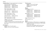
...times for a stationary receiver with a clear view of the sky.) GPSMAP 430/430s GPSMAP 440/440s GPSMAP 530/530s GPSMAP 535/535s GPSMAP 530/540s GPSMAP 535/545s
Warm:* Approximately 15 seconds Cold:** Approximately 45 seconds
GPSMAP 431/431s GPSMAP 441/441s GPSMAP 531/531s GPSMAP 541/541s
Warm:* Approximately... was turned off, or it has been turned off for more than 2 weeks.
GPS Accuracy: Position:
Owner's Manual - Page 78

... region as defined by your dealer or Garmin Product Support to perform the function you entered... DSC Position Report Received From-shows the MMSI or name associated ... in the DSC directory.
Lost Satellite Reception-the unit has lost satellite signals. NMEA Depth Is Below... Found-attempted to transfer on the SD card.
GPSMAP 400/500 Series Owner's Manual Delete unneeded contacts to...
Owner's Manual - Page 83

... weather 47 Appearance 53 Auto Magnetic 42 automatic guidance 21, 43 autopilot 33
B
backing up data 39 backlight, adjusting 4 Beeper/Display 41 BlueChart g2 Vision
using 33-37 bottom lock 54 buttons 5
C
Calibrate Water Speed 48 Chart/Sonar screen
using 21 chart data 10 charts
detail 14 fish eye 3D 18 fishing 19 mariner...
Similar Questions

Sd Card Slot Wont Read My G2 Card
I think the SD slot no longer reads cards on my Garmin 545S. I tested my G2 card on another Garmin b...
I think the SD slot no longer reads cards on my Garmin 545S. I tested my G2 card on another Garmin b...
(Posted by BrianCallahan 3 years ago)

How Do I Go Into Simulation Mode On A Garmin Marine Gps Modle741xs
how do I use simulation mode on a garmin 741xs marine ver
how do I use simulation mode on a garmin 741xs marine ver
(Posted by Curthupp 6 years ago)

Garmin 545 Blank Screen
It was working fine. Then screen went blank. Keys are still backlit so getting power.
It was working fine. Then screen went blank. Keys are still backlit so getting power.
(Posted by markpieczonka 9 years ago)

My Garmin Gps 545s Screen Freezes Up Has To Be Repowered,
Garmin told me I could down load updated map, I dont think I should try this. Is there someone I cou...
Garmin told me I could down load updated map, I dont think I should try this. Is there someone I cou...
(Posted by home07 10 years ago)

Gpsmap 431s Was Working And Then Screen Freeze And Does Not Start Anymore
GPSMAP 431S was working and then screen freeze and does not start anymore. It shows no map only some...
GPSMAP 431S was working and then screen freeze and does not start anymore. It shows no map only some...
(Posted by leomarchevsky 10 years ago)