Garmin GPSMAP 541s Support Question
Garmin GPSMAP 541s Support Question
Find answers below for this question about Garmin GPSMAP 541s - Marine GPS Receiver.Need a Garmin GPSMAP 541s manual? We have 8 online manuals for this item!
Question posted by krmc on June 24th, 2012
Looses Waypoints
after being turned off for week waypoints are losted
Current Answers
Related Garmin GPSMAP 541s Manual Pages
Installation Instructions - Page 8
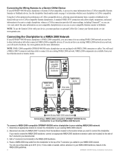
... Route a NMEA 2000 drop cable from your local Garmin dealer or marine dealer. NOTE: NMEA 2000-compatible GPSMAP 400/500 series chartplotters are available from the chartplotter to the top ...Connecting the Wiring Harness to a Garmin CANet Device If your GPSMAP 400/500 series chartplotter is Garmin CANet-compatible, it can receive sonar information from a sounder or fishfinder to be sent to ...
Quick Reference Guide - Page 2

... ). RANGE (-/+)-Press to manually adjust the backlight.
Zooming In and Out on the unit, the GPS receiver must collect satellite data and establish the current location. From the Navigation chart, use the map pointer...to return to start the new route.
Select Use Chart or Use Waypoint List. 3. If you
want to edit the route turns. If you pan past the edge of the Home screen are ...
Technical Reference for Garmin NMEA 2000 Products - Page 3
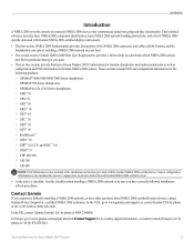
...products: ◦ GPSMAP® 4000/5000/6000/7000 Series chartplotters ◦ GPSMAP 700 Series chartplotters ◦ GPSMAP 4x1/5x1/5x6 Series chartplotters ◦ GMI™ 10 ◦ GPS 17x ◦ ... two sections provide Parameter Group Number (PGN) information for Garmin chartplotters and marine instruments as well as configuration and PGN information for Garmin NMEA 2000 Products
iii...
Technical Reference for Garmin NMEA 2000 Products - Page 22
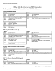
... 127489 127497 127505
127505
Fluid Level (when calibrated using a Garmin chartplotter or marine instrument)
GRA 10 (Garmin Rudder Angle Adapter)
Transmit
Receive
059392
ISO Acknowledgment
059392
060928
ISO Address Claim
059904
126208
NMEA - GPS 17x (GPS Antenna)
Transmit
Receive
059392 060928 126208 126464 126992 126996 129025 129026 129029 129539 129540
ISO Acknowledgment ISO...
Technical Reference for Garmin NMEA 2000 Products - Page 28
... compare information displayed on the fuel-flow rate.
Using Fuel-Level Information With a Garmin Chartplotter or Marine Instrument To receive fuel-level information, connect the wiring harness on your boat. Tip: The serial number of your NMEA...tank you fill up the tank. Select either GPS Speed or Water Speed to specify which speed sensor is connected to the GFS 10 Installation ...
Owner's Manual - Page 4
... iv
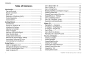
Getting Started 1 Unit Overview 1 Turning the Unit On or Off 2 Initializing Unit Settings 3 Adjusting the Backlight 4 Using the Keypad 5 Acquiring GPS Satellite Signals 5 Using Simulator Mode 5 ...System 22
Where To 28 Navigating to a Destination 28 Creating and Using Waypoints 30 Creating and Using Routes 31 Using Tracks 33 Using BlueChart g2 ...GPSMAP 400/500 Series Owner's Manual
Owner's Manual - Page 8
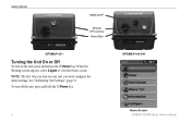
.../541
Home Screen
GPSMAP 400/500 Series Owner's Manual Note: The first time you turn on the unit, press and release the Power key.
When the Warning screen appears, select I Agree to view the Home screen. Getting Started
NMEA 2000®
External GPS antenna Power/Data
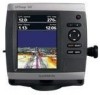
GPSMAP 431
Turning the Unit On or Off
To turn on...
Owner's Manual - Page 11
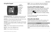
... try to adjust the backlight level.
SELECT-Press to select highlighted items.
HOME-Press to return to mark a waypoint at your current location.
Press to return to access additional settings and configuration options.
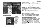
Using Simulator Mode
Simulator mode turns the GPS receiver off .
Getting Started
MENU-Press to the previous screen when indicated. Acquiring...
Owner's Manual - Page 32
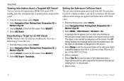
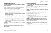
...zone Collision Alarm The safe-zone collision alarm can view the AIS signal status, MMSI, GPS speed, GPS heading, and other information that a target will intersect the safe zone within the defined ...for an AIS Vessel Note: Mariner's Eye 3D charts are applied to all charts and to select an AIS vessel. Select AIS Vessel > Deactivate.
Select a time.
26
GPSMAP 400/500 Series Owner's Manual...
Owner's Manual - Page 41

...In addition to detailed marine charting, BlueChart g2 Vision has the following features:
• Mariner's Eye 3D-provides ...should ground yourself on BlueChart g2 Vision-compatible Garmin GPS units and when using HomePort. You can transfer BlueChart...Navigating with NMEA 2000 compatible chartplotters (GPSMAP 441/441s, GPSMAP 536/536s, GPSMAP 541/541s, and GPSMAP 546/546s).
Note: You cannot ...
Owner's Manual - Page 59
...when you are within a specified distance or time from a turn or destination waypoint.
• Type-select whether you have a built-in...Configure > Alarms > Navigation. GPSMAP 400/500 Series Owner's Manual
53
Note: You must be receiving NMEA sonar depth data or have...arrival alarms to sound when the GPS location accuracy falls outside the specified value. GPS Accuracy-set an alarm to sound...
Owner's Manual - Page 65
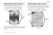
... Log. Depth
Time elapsed
Depth range
Using Sonar
Understanding the Temp Log Screen
If you are shown in the top-left as information is received. Temp Log
GPSMAP 400/500 Series Owner's Manual
59
Temp and depth
Time elapsed
Temperature range
Depth Log
The depth appears along the right side, and the...
Owner's Manual - Page 91

... deep water 53 fish 54 fuel 54 GPS accuracy 53 navigation 53 off course 53 shallow... 64 list 64
E
edit a route 32 edit existing waypoint 30 EGNOS 48 engine gauges
customizing limits 38 selecting the...chart 19
AIS 27 MARPA 27 fishing information 73
GPSMAP 400/500 Series Owner's Manual 85 Time 49 barometric...
detail 13 fish eye 3D 18 fishing 19 mariner's eye 3D 16 navigation 8 settings 12 cleaning...
Owner's Manual - Page 92
...Data Transfer 51 go to 28 GPS 5, 48, 78 GPS heading 42 Grid (North) 49 grid coordinates
creating waypoints using 30 ground wind 41 ...Mariner's Eye 3D
AIS 27 MARPA 27 mariner's eye 3D colors 17 mark current location 30
MARK key 5 MARPA
threats 27 measuring distance 31 MENU key 5 messages 79 move a waypoint...
Q
quick links i
GPSMAP 400/500 Series Owner's Manual Precision 51 Power/Backlight key 5 ...
Owner's Manual - Page 4
... iv
Getting Started 1 Unit Overview 1 Turning the Unit On or Off 3 Initializing Unit Settings 3 Adjusting the Backlight 4 Using the Keypad 5 Acquiring GPS Satellite Signals 5 Using Simulator Mode 6 ...System 22
Where To 27 Navigating to a Destination 27 Creating and Using Waypoints 29 Creating and Using Routes 30 Using Tracks 31 Using BlueChart g2 ...GPSMAP 400/500 Series Owner's Manual
Owner's Manual - Page 11
...
Getting Started
POWER/BACKLIGHT-Press and hold to turn on the unit, the GPS receiver must collect satellite data and establish the current location. SELECT-Press to select highlighted items.
HOME-Press to return to access additional settings and configuration options. MARK-Press to mark a waypoint at the top of the sonar. MENU-Press...
Owner's Manual - Page 12
...GPS receiver is located on Simulator mode: 1.
The unit does not track satellites in until it from the chartplotter.
6
GPSMAP 400/500 Series Owner's Manual
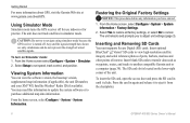
You may need this information to update the system software or to cancel. The SD card slot is turned... information. Insert blank SD cards to transfer data such as waypoints, routes, and tracks to eject it clicks. Press the card ...
Owner's Manual - Page 31
... AIS Vessel Note: The Fishing chart and Mariner's Eye 3D are available with a preprogrammed BlueChart g2 Vision data card.
1.
Using Charts
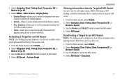
Viewing Information about a Targeted AIS Vessel You can view the AIS signal status, MMSI, GPS speed, GPS heading, and other information that appears using a trail, or turn the trail off. Select AIS Vessel...
Owner's Manual - Page 39
...
When you start any type of interest (POIs) along the shore.
GPSMAP 400/500 Series Owner's Manual
33 Note: You cannot transfer BlueChart g2 Vision data from the SD card to detailed marine charting, BlueChart g2 Vision has the following features:
• Mariner's Eye 3D-provides a view from above and behind the boat...
Owner's Manual - Page 83
...49 deep water 46 fish 46 fuel 47 GPS accuracy 46 navigation 45 safe-zone 49 shallow...10 charts
detail 14 fish eye 3D 18 fishing 19 mariner's eye 3D 16 navigation 8 settings 12 cleaning the... 34 compass rose 12 contact information, Garmin iv
GPSMAP 400/500 Series Owner's Manual
course up 13 ... 56 list 56
E
edit a route 31 edit existing waypoint 29 EGNOS 41
F
factory settings, restoring 6 fish eye...
Similar Questions

What Is Wrong
my Garmin GPSMAP 6012 turns itself off after a while and I have to restart it every know an then. Al...
my Garmin GPSMAP 6012 turns itself off after a while and I have to restart it every know an then. Al...
(Posted by Captjul 6 years ago)

How Do I Go Into Simulation Mode On A Garmin Marine Gps Modle741xs
how do I use simulation mode on a garmin 741xs marine ver
how do I use simulation mode on a garmin 741xs marine ver
(Posted by Curthupp 6 years ago)

Gps/map 541s Has No Power
I have tring all conection have their is no power
I have tring all conection have their is no power
(Posted by harrypage 10 years ago)

541s Marine Gps. Depth Not Reading Out.
Depth has been working since installed. Now blank. Is there an on off control for this that may have...
Depth has been working since installed. Now blank. Is there an on off control for this that may have...
(Posted by therad50 11 years ago)

How I Can Change From Meters To Feet To A Gpsmap 541s Marine?
(Posted by dvazquezpr 11 years ago)