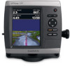
Garmin GPSMAP 531/531s Support Question
Garmin GPSMAP 531/531s Support Question
Find answers below for this question about Garmin GPSMAP 531/531s.Need a Garmin GPSMAP 531/531s manual? We have 6 online manuals for this item!
Question posted by shop5435 on February 25th, 2014
How Can I Calibrate My Garmin 531?
The person who posted this question about this Garmin product did not include a detailed explanation. Please use the "Request More Information" button to the right if more details would help you to answer this question.
Current Answers


Related Garmin GPSMAP 531/531s Manual Pages
Installation Instructions - Page 1
...Install the transducer, if applicable (page 3). 4. Chartplotter GPSMAP 420/430/430x/440/440x/450 GPSMAP 520/525/530/535/540/545/550/555 GPSMAP 421/441/451 GPSMAP 431/531 GPSMAP 521/526/536/541/546/551/556
NMEA 2000 ...No No Yes No Yes
NMEA 0183 Yes Yes Yes Yes Yes
Garmin CANet...
Installation Instructions - Page 3
... Phillips screwdriver
F
H
• Marine sealant
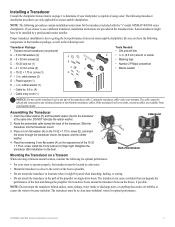
I - GPSMAP 400/500 Series Installation Instructions
If you have the following for the transducer included with the "s" model GPSMAP 400/500 series chartplotters. Cable tie,... I
Notice: Do not cut the transducer lead or any existing (Garmin or non-Garmin) transducer cables. Assembling the Transducer
1. Place the remaining 5 mm ...
Installation Instructions - Page 8
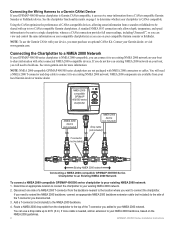
... NMEA 2000 connectors or cables. Add a T-connector (not included) to the side of a NMEA 2000 T-connector from your local Garmin dealer or marine dealer.
Connecting the Wiring Harness to a Garmin CANet Device If your GPSMAP 400/500 series chartplotter is CANet compatible. If you will need to extend the NMEA 2000 backbone, connect an...
Installation Instructions - Page 10

..., high-impact plastic alloy, waterproof to see if the signal improves.
3. Update Rate: 1/second, continuous
GPS Accuracy: Position: Range: From 5ºF to 131ºF (from -15ºC to be working properly... 55ºC)
Compass-Safe Distances:
Model Number
GPSMAP 526/536/546/556 GPSMAP 421/431/441/451 GPSMAP 521/531/541/551 GPSMAP 420/430/440/450 GPSMAP 520/530/540/550/525/535/545/555
...
Owner's Manual - Page 3
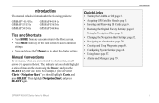
...Introduction
Quick Links
• Turning the Unit On or Off: page 3. • Acquiring GPS Satellite Signals: page 5. • Inserting and Removing SD Cards: page 6. • Restoring ...GPSMAP 400/500 Series Owner's Manual Introduction
This manual includes information for the following products:
GPSMAP® 431/431s GPSMAP 531/531s GPSMAP 541/541s
GPSMAP 441/441s GPSMAP 536/536s GPSMAP...
Owner's Manual - Page 4
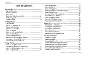
...Shortcuts i Manual Conventions i Quick Links i Declaration of Conformity (DoC iv Product Registration iv Contact Garmin iv
Getting Started 1 Unit Overview 1 Turning the Unit On or Off 2 Initializing Unit Settings 3 Adjusting the Backlight 4 Using the Keypad 5 Acquiring GPS Satellite Signals 5 Using Simulator Mode 5 Viewing System Information 6 Restoring the Original Factory Settings...
Owner's Manual - Page 11
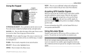
... indoors or for practice. For more information about GPS, visit the Garmin Web site at the top of the Home screen are only simulations and do not represent the strength of the sonar.
Press to return to adjust the backlight and day and night modes.
GPSMAP 400/500 Series Owner's Manual Press and...
Owner's Manual - Page 13
...MapSource or HomePort by clicking Help > Check for Software Updates, or check the Garmin Web site at www.garmin.com. GPSMAP 400/500 Series Owner's Manual
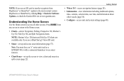
Understanding the Home Screen
Use the Home screen ...to view a chart and sonar in a split screen (page 22).
Note: Mariner's Eye ...
Owner's Manual - Page 32
...select Charts.
2. Select Navigation Chart, Fishing Chart, Perspective 3D, or Mariner's Eye 3D.
3. Select a time.
26
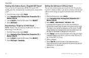
GPSMAP 400/500 Series Owner's Manual A message banner appears and an alarm ...Viewing Information about a Targeted AIS Vessel You can view the AIS signal status, MMSI, GPS speed, GPS heading, and other information that a target will intersect the safe zone within the defined ...
Owner's Manual - Page 41

... transfer BlueChart g2 Vision data from the SD card to engage the autopilot. GPSMAP 400/500 Series Owner's Manual 35 Optional BlueChart g2 Vision preprogrammed SD cards ...get the most out of your computer for backup. The BlueChart g2 Vision Mariner's Eye 3D is installed on BlueChart g2 Vision-compatible Garmin GPS units and when using HomePort. In low-humidity environments, you to your PC...
Owner's Manual - Page 54
...Home screen, select Configure > System. GPS-view GPS satellites.
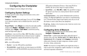
• Skyview-view the GPS satellite constellation • WAAS/EGNOS-...temperature, distance, speed, elevation, volume, and pressure. GPSMAP 400/500 Series Owner's Manual Configuring the Chartplotter
Configuring the...boat over a short period of your chartplotter. A Garmin Product Support representative may ask you to use this ...
Owner's Manual - Page 57

..., until you selected Nearest or Farthest, review the placement of standard 0183 data for most AIS receivers.
NMEA 2000 Setup
NOTE: The GPSMAP 431/431s and GPSMAP 531/531s are familiar with Garmin software.
• NMEA Standard-supports the input or output of standard NMEA 0183 data, DSC, and sonar NMEA input support for transmission...
Owner's Manual - Page 60
...amount of the boat. Turn the following alarms on or off: marine, tornado, severe
storm, flood, or flash flood. From the....
If the transducer is installed at
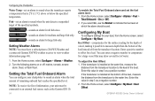
which the alarm should sound. GPSMAP 400/500 Series Owner's Manual From the Home screen, select Configure ...must have a subscription to XM WX Weather and a connected Garmin XM WX weather receiver to indicate the fuel level at ...
Owner's Manual - Page 61
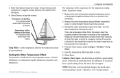
Ensure that you do not have a NMEA 0183 water-temperature sensor, a Garmin Intelliducer, or a temperature-capable transducer to the chartplotter measures the water temperature as being warmer than it actually is connected to calibrate a speed-sensing device. Transducer at Surface A (+) positive number shows depth at the surface. Enter this value in step 5 as...
Owner's Manual - Page 63
...
Depth
Temperature
Speed
Suspended targets
Range
Using Sonar
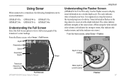
Understanding the Flasher Screen
(GPSMAP 431s/531s/536s only) Use the Flasher screen to display sonar information on the ... your boat. The scale indicates what is organized as fishfinders:
GPSMAP 431s GPSMAP 441s GPSMAP 531s GPSMAP 536s GPSMAP 541s GPSMAP 546s
Understanding the Full Screen
Select the Full Screen option to ...
Owner's Manual - Page 83
.../500 Series Owner's Manual 77
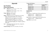
Temperatur Range: From 5ºF to 131ºF (from -15ºC to IEC 529 IPX7 standards. GPSMAP 531/541: 5.0 in . GPSMAP 431/431s GPSMAP 441/441s GPSMAP 531/531s GPSMAP 541/541s High-sensitivity, 12 parallel channel, WAAS-capable receiver. diagonal (12.7 cm), QVGA display with adjustable brightness, 320 × 240 pixels.
Appendix
Specifications...
Owner's Manual - Page 84
GPS Accuracy: Position: Appendix
Acquisition Times: (Average acquisition times for a stationary receiver with a clear view of the sky) GPSMAP 431/431s GPSMAP 441/441s GPSMAP 531/531s GPSMAP 541/541s
Warm:* Approximately 1 second Cold:** Approximately 38 seconds
GPSMAP 536/536s GPSMAP 546/546s
Warm:* Approximately 15 seconds Cold:** Approximately 38 seconds
*Warm: your unit is at or near the last...
Owner's Manual - Page 85
... Write User Card, Card May Be Full-error reading card; GPSMAP 400/500 Series Owner's Manual 79 Arrival At [Waypoint Name]-you... voltage-the unit shuts off .
Contact your dealer or Garmin Product Support. Card Needed-Your unit needs to have drifted...the speed wheel to Calibrate-the boat is crimped, broken, or contacting the chassis. Accuracy Alarm-the GPS accuracy has fallen outside...
Owner's Manual - Page 91

...Calibrate Water Speed 55 celestial information 43 Chart/Sonar screen
using 22 Chart Borders 14 chart data 10 charts
detail 13 fish eye 3D 18 fishing 19 mariner...'s eye 3D 16 navigation 8 settings 12 cleaning the unit 82
Clear User Data 44 close hauled wind gauge 42 collision alarm 26 colors, hazard 17 Color Scheme 61 Communications 51 Compass 36 compass rose 12 contact information, Garmin...GPS...
Owner's Manual - Page 92
...GPSMAP 400/500 Series Owner's Manual Index
Fish Symbols 18, 60 flasher 57 forecast information 72 frequency 61 Fuel Capacity 56 fuel gauges
synchronizing 40 viewing 40 full screen, sonar 57 Full Screen Map 9 fuse 78
G
gain 61 Garmin Data Transfer 51 go to 28 GPS 5, 48, 78 GPS... Zoom 61 map datum 49 MapSource data 44 Mariner's Eye 3D
AIS 27 MARPA 27 mariner's eye 3D colors 17 mark current location 30...
Similar Questions

How Do I Go Into Simulation Mode On A Garmin Marine Gps Modle741xs
how do I use simulation mode on a garmin 741xs marine ver
how do I use simulation mode on a garmin 741xs marine ver
(Posted by Curthupp 6 years ago)

Our Garmin Will Not Power Up. Does It Have To Have Sim Card To Power Up?
(Posted by dudleybv 8 years ago)

541s Marine Gps. Depth Not Reading Out.
Depth has been working since installed. Now blank. Is there an on off control for this that may have...
Depth has been working since installed. Now blank. Is there an on off control for this that may have...
(Posted by therad50 11 years ago)

Calibrate Compass On Gps Map 78
when I go to calibrate compass it does not have a calibrate setting in the menu mode
when I go to calibrate compass it does not have a calibrate setting in the menu mode
(Posted by catchhopper 11 years ago)