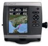
Garmin GPSMAP 521/521s Support Question
Garmin GPSMAP 521/521s Support Question
Find answers below for this question about Garmin GPSMAP 521/521s.Need a Garmin GPSMAP 521/521s manual? We have 7 online manuals for this item!
Question posted by Chadasheraw on August 22nd, 2013
Compass Safe Distance
I am putting a garmin 521s on the dash of a 19' boston whaler montauk. There is a compass located in front of the steering wheel, if I mount the garmin 22" from the compass will it interfere with the garmin or the compass?
Thanks
Current Answers
Related Garmin GPSMAP 521/521s Manual Pages
Flush Mount Kit Instructions (multilingual) - Page 1
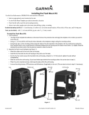
...mount a GPSMAP 500 series unit into the unit housing so they stick out of the back. • Use the four hex nuts to secure the hex bolts to the unit housing. Remove the protective liner and apply the template to the location...housing.
• Connect the wiring harness, GPS antenna, and XM antenna (if applicable) to begin cutting the mounting surface.
• Using the jig saw , and a 9/32"...
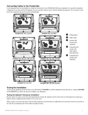
Installation Instructions - Page 2
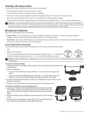
... the compass-safe distance table on the back of the chartplotter with countersunk heads, you may damage the mounting bracket. The compact waterproof chartplotter housing is strong enough to support the weight of the chartplotter and protect it from -15°C to tighten.)
2. The bracket clicks as you operate your boat. • The location allows...
Installation Instructions - Page 4
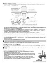
... not tight. (The cable tie clicks when you complete the GPSMAP 400/500 series chartplotter installation. Position the transducer mount at 1 in use, making sure the gasket is parallel with the water line. Do not mount the transducer directly in . (9.5 mm) deep.
7. Apply marine sealant to all screw threads to be aligned parallel with...
Installation Instructions - Page 9
... not leave your chartplotter for leaks. GPSMAP 400/500 Series Installation Instructions You cannot get a depth or distance reading when the transducer is not represented... 2000 ➌ External GPS
antenna (sold separately)
➍ Compatible XM
antenna with audio adapter (sold separately)
➎ Compatible XM
antenna (sold separately)
GPSMAP 521, 541, 551
GPSMAP 526, 536, 546, and...
Installation Instructions - Page 10

...55ºC)
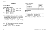
Compass-Safe Distances:
Model Number
GPSMAP 526/536/546/556 GPSMAP 421/431/441/451 GPSMAP 521/531/541/551 GPSMAP 420/430/440/450 GPSMAP 520/530/540/550/525/535/545/555
Compass-Safe Distance 20 in... view of the boat and put the transducer at a slow speed. GPSMAP 520/521/530/531/540/541/550/551 (s): 5.0 in . Update Rate: 1/second, continuous
GPS Accuracy: Position:
Begin testing ...
Technical Reference for Garmin NMEA 2000 Products - Page 2
....
Except as expressly provided herein, no part of this manual or any unauthorized commercial distribution of this document is strictly prohibited. Garmin®, the Garmin logo, and GPSMAP® are registered trademarks of such changes or improvements. These trademarks may be reproduced, copied, transmitted, disseminated, downloaded or stored in any storage medium, for...
Technical Reference for Garmin NMEA 2000 Products - Page 16

... Speed
129026 - GNSS Position
129026 - Vessel Heading
129026 - Water Depth
130312 - GNSS Position
None
None
Typical Sender Depth Transducer Water Temperature Sensor
Water Speed Sensor GPS Antenna, Water Speed Sensor, and Heading Sensor GPS Antenna, Water Speed Sensor, and Heading Sensor GPS Antenna GPS Antenna None None
12
Technical Reference for Garmin NMEA 2000 Products
Important Safety and Product Information - Page 2
... more information. Battery Warnings Your GPS unit may use a combination of... precise measurement of Garmin is to mariners contain all data sources...distance, location,
or topography.
• If your unit has video input capabilities, do not attempt to operate or watch video input while operating or navigating your unit contains or accepts mapping products, follow these guidelines to ensure safe...
Owner's Manual - Page 3
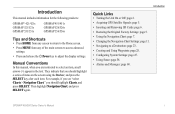
.... Introduction
Quick Links
• Turning the Unit On or Off: page 2. • Acquiring GPS Satellite Signals: page 5. • Inserting and Removing SD Cards: page 6. • Restoring ... GPSMAP 400/500 Series Owner's Manual Introduction
This manual includes information for the following products:
GPSMAP® 421/421s GPSMAP 521/521s GPSMAP 551/551s
GPSMAP 451/451s GPSMAP 526/526s GPSMAP...
Owner's Manual - Page 7

Unit Overview
GPSMAP 526/556
Getting Started
NMEA 2000®
Power/Data
External GPS antenna
GPSMAP 421/451/ 521/551
Power/Data
NMEA 2000®
GPSMAP 400/500 Series Owner's Manual
External GPS antenna
Getting Started
POWER/ BACKLIGHT RANGE (-/+) ROCKER MARK SELECT MENU HOME
SD card slot GPSMAP 526 shown
Owner's Manual - Page 13
...to view map information, and as a three-dimensional navigation aid.
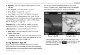
The BlueChart g2 Vision Mariner's Eye 3D is more detailed than the preloaded data. Note: If you are available ... chart, from above and behind the boat as a navigational aid. GPSMAP 400/500 Series Owner's Manual
Fishing charts are using a GPSMAP 421, 521, or 526 (including "s" models), you use a BlueChart g2 Vision...
Owner's Manual - Page 15

...Select Data Bar Setup to configure the data shown on the screen.
• Navigation-turn the Distance to provide the current heading, and an indicator that follow the standards for BlueChart g2 and ... speed and wind angle.
• Compass Tape-displayed at the top of the screen to Destination, Arrival, Off Course, and Bearing data bar on or off .
GPSMAP 400/500 Series Owner's Manual
...
Owner's Manual - Page 21
... navigating tricky shoals, reefs, bridges, or channels, and is beneficial when trying to provide distance measurement.
• Lane Width-adjusts the width of the course line drawn when navigating.
...Mariner's Eye 3D that have been saved. aid. GPSMAP 400/500 Series Owner's Manual 15
Data Bars (page 8)-show or hide the numbers for cruising, navigation, fishing, fuel, sailing, or the compass ...
Owner's Manual - Page 22

...beacons, lights, and obstructions: 1. Safe Depth-adjusts the depth at which red indicates dangerous depths. When the cursor is very shallow water. Mariner's Eye 3D Settings To access additional ... Mariner's Eye 3D screen, select MENU > Chart Appearance. GPSMAP 400/500 Series Owner's Manual
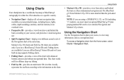
Using Charts To view details about the navaid. For settings and options related to provide distance ...
Owner's Manual - Page 25

... Vision SD cards contain aerial photographs of many landmarks, marinas, and harbors. Note: When enabled, the high-resolution satellite images are only present at 100% GPSMAP 400/500 Series Owner's Manual 19 Use these photos to help orient yourself to arrival.
Owner's Manual - Page 36
...Garmin GPS units. This chart works well for offshore deep-sea fishing.
30
• High Resolution Satellite Imagery-provides high-resolution satellite images for backup or viewing purposes.
GPSMAP 400/500 Series Owner's Manual The BlueChart g2 Vision Mariner...
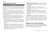
• Auto Guidance-uses the chart data and specified boat-safe depth to determine the best course to the card.
Optional BlueChart...
Owner's Manual - Page 51

..., GPS heading, and other information that appears using a trail. Select AIS Vessel.
Select Navigation Chart, Fishing Chart, Perspective 3D, or
Mariner's Eye 3D. Fishing charts are available if you use a BlueChart g2 Vision SD card or if your built-in map supports Fishing charts.
1. Select AIS Vessel > Activate Target.
Press SELECT. All safe...
Owner's Manual - Page 55

... Guidance-set the automatic guidance parameters:
• Safe Depth-set the minimum depth (chart depth datum) to known obstacles, from the Home screen, select Configure > Preferences > Navigation > Auto Guidance > Shoreline Distance > Far.
• If the turns in the Auto Guidance line are relative, not absolute. GPSMAP 400/500 Series Owner's Manual
49 Review...
Owner's Manual - Page 72
....7 cm), Full VGA display with adjustable brightness, 320 × 234 pixels. Case: Fully gasketed, high-impact plastic alloy, waterproof to 55ºC)
Compass-Safe Distances:
Model Number
GPSMAP 526/556 GPSMAP 421/451 GPSMAP 521/551
Compass-Safe Distance 20 in. (50 cm)
26 in. (65) cm
30 in .
Range: From 5ºF to 131ºF (from -15ºC to IEC...
Owner's Manual - Page 79
... 38 Chart/Sonar screen
using 22 Chart Borders 13 chart data 9
charts detail 12 fish eye 3D 17 fishing 17 mariner's eye 3D 15 navigation 7 settings 11
Clear User Data 39 collision alarm 55 colors, hazard 16 Color Scheme 60 Communications 50 Compass 31 compass rose 12 Compass Tape 9 contact information, Garmin iv coordinates, grid
creating...
Similar Questions

How Do I Go Into Simulation Mode On A Garmin Marine Gps Modle741xs
how do I use simulation mode on a garmin 741xs marine ver
how do I use simulation mode on a garmin 741xs marine ver
(Posted by Curthupp 6 years ago)

My Gps Won't Power Up
my gps won't power up,and when it did it just showed the screen garmin then shut off
my gps won't power up,and when it did it just showed the screen garmin then shut off
(Posted by harlequin687 7 years ago)

Our Garmin Will Not Power Up. Does It Have To Have Sim Card To Power Up?
(Posted by dudleybv 8 years ago)

541s Marine Gps. Depth Not Reading Out.
Depth has been working since installed. Now blank. Is there an on off control for this that may have...
Depth has been working since installed. Now blank. Is there an on off control for this that may have...
(Posted by therad50 11 years ago)