Garmin GPSMAP 520s Support Question
Garmin GPSMAP 520s Support Question
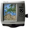
Find answers below for this question about Garmin GPSMAP 520s - Marine GPS Receiver.Need a Garmin GPSMAP 520s manual? We have 1 online manual for this item!
Question posted by giannisc on December 27th, 2012
Connect With Nmea 2000
hi
i have a garmin gpsmap 520s. may i connect the gps with my outboard yamaha f 115 which suport nmea 2000.
Current Answers
Related Garmin GPSMAP 520s Manual Pages
Owner's Manual - Page 2

...used without notice. Garmin®, the Garmin logo, GPSMAP®, BlueChart®, g2 Vision®, and MapSource® are trademarks of Garmin Ltd.
or its subsidiaries
Garmin International, Inc. 1200...8501251
Garmin Corporation No. 68, Jangshu 2nd Road, Sijhih, Taipei County, Taiwan Tel. 886/2.2642.9199 Fax 886/2.2642.9099
All rights reserved. NMEA 2000® and the NMEA 2000 logo ...
Owner's Manual - Page 4

...Shortcuts i Manual Conventions i Quick Links i Declaration of Conformity (DoC iv Product Registration iv Contact Garmin iv
Getting Started 1 Unit Overview 1 Turning the Unit On or Off 3 Initializing Unit Settings 3 Adjusting the Backlight 4 Using the Keypad 5 Acquiring GPS Satellite Signals 5 Using Simulator Mode 6 Viewing System Information 6 Restoring the Original Factory Settings...
Owner's Manual - Page 9
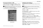
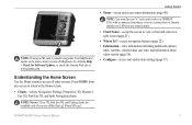
... ports are connected. Welcome-select OK.
Note: The first time you turn on the unit, press and release the Power key. Home Screen GPSMAP 400/500 ...receiver. System Units-specify units for location readings.
Store Demonstration-select NO. (This option is only available the first time the unit is not available if you select None for NMEA Devices)-Select Yes if one of the devices connected...
Owner's Manual - Page 13
... 37). Note: Mariner's Eye 3D, Fish Eye 3D, and Fishing charts are available only if you use sonar features.
• Chart/Sonar-set up the screen to use a BlueChart g2 Vision SD card. Note: You must have an "s" series unit (such as a GPSMAP 526s) with a connected transducer or have a connection to a Garmin sounder via CANet...
Owner's Manual - Page 18
...station information appears on or off (page 32).
Service Points-turns marine service points on the chart with the map pointer,
and press SELECT...using a BlueChart g2 Vision SD card. Selected item
2.
High-resolution satellite imagery is connected to a compatible marine wind sensor.
12
GPSMAP 400/500 Series Owner's Manual Roses-displays a compass rose around your boat, indicating ...
Owner's Manual - Page 21

...the Range (-) key to move the view closer to your course), and provides a visual navigation
GPSMAP 400/500 Series Owner's Manual 15 Press SELECT to your boat and lower to the water. ...Charts > Perspective 3D.
Using Mariner's Eye 3D
A BlueChart g2 Vision SD card offers Mariner's Eye 3D that have been saved. Press the Range (+) key to your unit must be connected to identify entry routes and...
Owner's Manual - Page 40

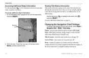
...to copy the maps loaded onto your chartplotter, select Information > User Data > Data Transfer.
9. Connect the unit to a NMEA 2000 network. (Refer to create a new file. Insert the SD card into the SD card slot... file name from the list.
• Select Add New File to the
GPSMAP 400/500 Installation Instructions.)
34
GPSMAP 400/500 Series Owner's Manual The data is transferred from the SD card ...
Owner's Manual - Page 41
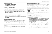
... > User Data > Data Transfer > Replace From Card.
To delete all the chartplotters connected to a computer. From the Home screen on your chartplotter, select Information >
User Data...Garmin\UserData folder.
3. Unique data is overwritten on the front of the following units are NMEA 2000 compatible:
GPSMAP 421/421s GPSMAP 451/451s GPSMAP 551/551s
GPSMAP 521/521s GPSMAP 526/526s GPSMAP...
Owner's Manual - Page 43
...Garmin sounder module to acquire satellites.
• Speed Filter-select On, Off, or Auto.
System Units-a global setting that defines individual units of measure for smoother speed values. Note: You must be receiving NMEA... settings. The Save to set simulator options, such as a troubleshooting tool; GPSMAP 400/500 Series Owner's Manual 37 Select Setup to switch between Day mode ...
Owner's Manual - Page 46
... the input/output format for serial port 1 to use when connecting your chartplotter to external NMEA devices, a computer, or other Garmin devices.
• Garmin Data Transfer-supports the input or output of Garmin-proprietary data for communicating with Garmin software.
• Garmin Remote Sonar Transfer (GPSMAP
40
420/450/520/550/525/555)-supports the input or output of...
Owner's Manual - Page 47
... of options. Note: Only the following units are NMEA 2000 compatible:
GPSMAP 421/421s GPSMAP 451/451s GPSMAP 551/551s
GPSMAP 521/521s GPSMAP 526/526s GPSMAP 556/556s
CANet Devices-lists the CANet devices on ...alarms are met. Select an alarm category. 3. Select an alarm.
Note: Only the GPSMAP 420/450/520/550/525/555 (including "s" models) are CANet compatible:
Setting Alarms
You can set...
Owner's Manual - Page 48
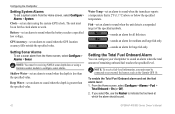
... be connected to sound when the transducer reports a temperature that is 2°F (1.1°C) above or below the specified temperature.
Battery-set an alarm to an external fuel sensor, such as the Garmin GFS 10.
Water Temp-set an alarm to sound when the GPS location accuracy falls outside the specified value.
Note: To receive...
Owner's Manual - Page 56

NMEA 0183 NMEA 2000 Garmin NMEA Garmin NMEA VHF Radio VHF Radio 0183 VHF Radio 2000 VHF Radio
X
X
X
X
X
X
X
X
X
X
X
X
X
X
X
50
GPSMAP 400/500 Series Owner's Manual If your radio is capable, GPS position information is transmitted with a VHF Radio
The following table indicates the features that are available when you connect your chartplotter, the radio displays the Distress ...
Owner's Manual - Page 57
...connected via NMEA 0183 or NMEA 2000, your chartplotter alerts you when your Garmin chartplotter and VHF radio are using a Garmin NMEA 2000compatible VHF radio.
• Select Edit to edit the vessel name and add a comment.
Use the on making an individual routine call , that information is received...or off . If position information was sent. GPSMAP 400/500 Series Owner's Manual
51 The DSC...
Owner's Manual - Page 58

... the DSC list (page 36). If your radio is tracking the position of position reports: 1. GPSMAP 400/500 Series Owner's Manual Digital Selective Calling
Man-Overboard Distress Calls Initiated from a VHF Radio
When your Garmin chartplotter is connected to a Garmin NMEA 2000-compatible radio and you initiate a man-overboard DSC distress call from your radio, your...
Owner's Manual - Page 59
...
DSC Trails. 2.
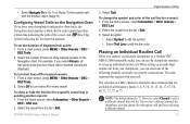
Placing an Individual Routine Call
When you connect your chartplotter, you can use the chartplotter interface to set... color. If you call from your Garmin chartplotter to a Garmin VHF NMEA 2000-compatible radio, you can select one ... transmits this request with the position report (page 11). GPSMAP 400/500 Series Owner's Manual
Digital Selective Calling
3. Select...
Owner's Manual - Page 60
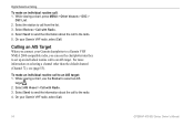
... to an AIS target. On your Garmin VHF radio, select Call.
54
GPSMAP 400/500 Series Owner's Manual
Calling an AIS Target
When you connect your Garmin chartplotter to a Garmin VHF NMEA 2000-compatible radio, you can use the Rocker to an AIS target: 1. Select AIS Vessel > Call with Radio. 4. On your Garmin VHF radio, select Call. While...
Owner's Manual - Page 67
... AGREEMENT. You acknowledge that the Software in source code form remains a valuable trade secret of Garmin.
GPSMAP 421/421s GPSMAP 451/451s GPSMAP 551/551s
GPSMAP 521/521s GPSMAP 526/526s GPSMAP 556/556s
To connect one of these chartplotter to an existing NMEA 2000 network and to any derivative works based on the boat.
You agree not to decompile...
Owner's Manual - Page 68
...44 deep water 42 fish 42 fuel 42 GPS accuracy 42 navigation 41 safe-zone 44 shallow ...10 charts
detail 13 fish eye 3D 17 fishing 18 mariner's eye 3D 15 navigation 8 settings 12 Clear User... 40 Compass 30 compass rose 12 contact information, Garmin iv
course up 13 current stations 32 customizing
chart...45 fuse 56
G
gain 49 Garmin Data Transfer 40 gauges
fuel 31 go to 22 GPS 5, 37, 56 Grid (North...
Owner's Manual - Page 69
...number 6
K
keel offset 43 keypad 5
NMEA 2000 Setup 41 NMEA High Speed 40 NMEA Standard 40 Noise Reject 49 north
grid 38...mariner's eye 3D
colors 17 mark current location 24 MENU key 5 messages 57 move a waypoint 24 My Boat 43
N
Navaid Type 14 Navigate To 11, 23, 25, 26, 53 Navigation Alarms 41 navigation charts 8 navigation preferences 38 New Waypoint 15 NMEA...GPSMAP 400/500 Series Owner's Manual 63
Similar Questions

How Do I Go Into Simulation Mode On A Garmin Marine Gps Modle741xs
how do I use simulation mode on a garmin 741xs marine ver
how do I use simulation mode on a garmin 741xs marine ver
(Posted by Curthupp 6 years ago)

Does Garmin 541 Need Power Cable With Nmea 2000?
(Posted by mritBala19 9 years ago)

Garmin 740 What Wires Are For Nmea 2000 And Gfs 10
(Posted by sriruthan 9 years ago)
Garmin 640 Gps Nmea 0183 Connect To 5212
(Posted by Gerronimo 10 years ago)
Connection Garmin Gpsmap 521 With Evinrude E-tec 50
HOW TO CONNECT GARMIN GPSMAP 521 S WITH EVINRUDE E-TEC 50 USING NMEA 2000 CABLES
HOW TO CONNECT GARMIN GPSMAP 521 S WITH EVINRUDE E-TEC 50 USING NMEA 2000 CABLES
(Posted by ante11 12 years ago)