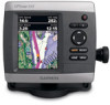
Garmin GPSMAP 441/441s Support Question
Garmin GPSMAP 441/441s Support Question
Find answers below for this question about Garmin GPSMAP 441/441s.Need a Garmin GPSMAP 441/441s manual? We have 8 online manuals for this item!
Question posted by Hechambe on March 17th, 2013
Loran Setting
How do I get to where I can put in loran numbers instead of GPS coords.
Current Answers
Related Garmin GPSMAP 441/441s Manual Pages
Installation Instructions - Page 1
... properly installed according to determine the feature set and installation requirements of your chartplotter: 1 Select a mounting location (page 2). 2. Test the installation (page 9). Mount the chartplotter (page 2). 3.
Chartplotter GPSMAP 420/430/430x/440/440x/450 GPSMAP 520/525/530/535/540/545/550/555 GPSMAP 421/441/451 GPSMAP 431/531 GPSMAP 521/526/536/541/546/551...
Installation Instructions - Page 9
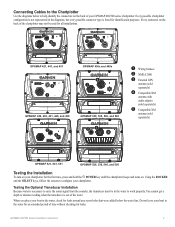
..., 441, and 451
➌ ➊
GPSMAP 430x and 440x
➍ ➊
GPSMAP 420, 430, 431, 440, and 450
➋ ➌
GPSMAP 530, 535, 540, and 545
➋➊
➊ Wiring harness ➋ NMEA 2000 ➌ External GPS
antenna (sold separately)
➍ Compatible XM
antenna with audio adapter (sold separately)
➎ Compatible XM
antenna (sold separately)
GPSMAP...
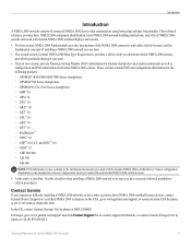
Installation Instructions - Page 10

...; 240 pixels. Case: Fully gasketed, high-impact plastic alloy, waterproof to 55ºC)
Compass-Safe Distances:
Model Number
GPSMAP 526/536/546/556 GPSMAP 421/431/441/451 GPSMAP 521/531/541/551 GPSMAP 420/430/440/450 GPSMAP 520/530/540/550/525/535/545/555
Compass-Safe Distance 20 in. (50 cm)
26 in. (65...
Technical Reference for Garmin NMEA 2000 Products - Page 3
... two sections provide Parameter Group Number (PGN) information for Garmin chartplotters and marine instruments as well as configuration and PGN information for the following products: ◦ GPSMAP® 4000/5000/6000/7000 Series chartplotters ◦ GPSMAP 700 Series chartplotters ◦ GPSMAP 4x1/5x1/5x6 Series chartplotters ◦ GMI™ 10 ◦ GPS 17x ◦ GFS™...
Owner's Manual - Page 3
...; Creating and Using Waypoints: page 30. • Configuring System Settings: page 48. • Using Sonar: page 57. • Alarms and Messages: page 79.
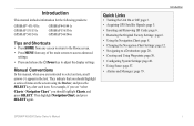
Introduction
This manual includes information for the following products:
GPSMAP® 431/431s GPSMAP 531/531s GPSMAP 541/541s
GPSMAP 441/441s GPSMAP 536/536s GPSMAP 546/546s
Tips and Shortcuts
• Press HOME from any...
Owner's Manual - Page 4
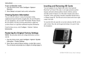
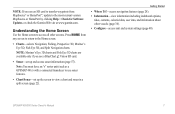
...GPS Satellite Signals 5 Using Simulator Mode 5 Viewing System Information 6 Restoring the Original Factory Settings 6 Inserting and Removing SD Cards 6 Understanding the Home Screen 7
Using Charts 8 Using the Navigation Chart 8 Changing the Navigation Chart Settings 12 Using the Split Navigation Chart 15 Using Perspective 3D 15
ii
Using Mariner...Compass 36 Viewing Numbers 36 Viewing ...
Owner's Manual - Page 8
... Unit Settings" (page 3). Getting Started
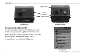
NMEA 2000®
External GPS antenna Power/Data
GPSMAP 431
Turning the Unit On or Off
To turn on your unit, you turn off the unit, press and hold the Power key.
To turn on the unit, press and release the Power key.
GPSMAP 441/541
Home Screen
GPSMAP 400/500...
Owner's Manual - Page 9

... (Automatic Identification System) receiver. Shallow Water Alarm-only available if you want to Auto. If Auto is selected for time readings.
Time Zone-set to calibrate it now. GPSMAP 400/500 Series Owner's Manual
Getting Started
System Units-specify units for on the screen. Refer to individually define units of the devices...
Owner's Manual - Page 11
... the previous screen when indicated. Press to return to access additional settings and configuration options.
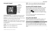
For more information about GPS, visit the Garmin Web site at the top of the Home ... not try to turn on lists, to scroll the map, or to adjust the backlight level. GPSMAP 400/500 Series Owner's Manual Using the Keypad
POWER/ BACKLIGHT
RANGE (-/+) ROCKER MARK SELECT MENU...
Owner's Manual - Page 12
... release it to adjust unit settings (page 3).
GPSMAP 400/500 Series Owner's Manual... Getting Started
To turn on the lower-right corner of interest. From the Home screen, select Configure > System >
Simulator. 2. Viewing System Information
You can view the software version, the basemap version, supplemental map information (if applicable), the unit ID number...
Owner's Manual - Page 13
... charts.
Note: Mariner's Eye 3D charts and Fish Eye 3D charts are available only if you use sonar features.
• Chart/Sonar-set up the screen to access all other vessels (page 36). • Configure-access unit and system settings (page 48). Note: You must have an "s" series unit (such as a GPSMAP 441s) with a connected...
Owner's Manual - Page 15

...33).
Data bars
• Cruising-turn the GPS Speed, GPS Heading, Depth, and GPS Position data bar on the cruising data bar....fishing, fuel, or sailing numbers. Stop Navigation-stop navigating to your chartplotter is connected to a destination. GPSMAP 400/500 Series Owner's ... Navigation Chart Menu To access additional settings or options for the Navigation chart, press MENU. Full ...
Owner's Manual - Page 18

... chart, highlight an item with a detailed icon showing the relevant tide level. Photos-sets the high-resolution satellite images to highlight a tide-station icon ( ), and press SELECT. Use the map pointer ( ) to Off, Land Only, or On. GPSMAP 400/500 Series Owner's Manual High-resolution satellite imagery is connected to show animated...
Owner's Manual - Page 22
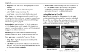
Mariner's Eye 3D
Navigation Chart
GPSMAP 400/500 Series Owner's Manual Weather Radar-turn ... Rings-toggles the range rings on or off to a weather module and you have been saved. This setting also affects routes (Route To), but does not affect Auto Guidance (Guide To).
16
• Weather...about other vessels.
Data Bars (page 9)-show or hide the numbers for additional information.
Owner's Manual - Page 24
This setting also affects ...).
18
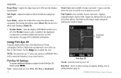
Sonar Cone (only available if sonar is present)-displays suspended targets (such as a GPSMAP 441s) with a connected transducer to adjust the view. Fish Symbols (only available if sonar is present...or hides cruising, navigation, fishing, fuel, or sailing numbers (page 9). GPSMAP 400/500 Series Owner's Manual
Lane Width-adjusts the width of the sea floor...
Owner's Manual - Page 27

... the Navigation chart: Use the Rocker to 2 knots
2 or more . GPSMAP 400/500 Series Owner's Manual
Using Charts
An indicator for a tide station appears...the current at the station appears above the direction indicator. To do so, information for the Tides/Currents setting (page 12).
with Falling Tide
Current direction indicators appear as a vertical bar graph with the pointer, and...
Owner's Manual - Page 32
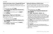
...Off setting disables the message banner and the audible alarm, but the object is reported about a Targeted AIS Vessel You can view the AIS signal status, MMSI, GPS speed, GPS ...Chart, Perspective 3D, or
Mariner's Eye 3D. 3. From the Home screen, select Charts.
2. Select a time.
26
GPSMAP 400/500 Series Owner's Manual Press SELECT. 4. Select Range to set the measured radius of the ...
Owner's Manual - Page 41

... to the card. The BlueChart g2 Vision Mariner's Eye 3D is installed on a large metal object before handling the card to prevent damage to your computer for a three-dimensional navigation aid (page 16). Navigating with NMEA 2000 compatible chartplotters (GPSMAP 441/441s, GPSMAP 536/536s, GPSMAP 541/541s, and GPSMAP 546/546s). Note: You cannot transfer BlueChart...
Owner's Manual - Page 84
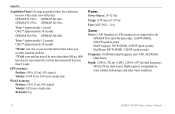
GPS Accuracy: Position:
Appendix
Acquisition Times: (Average acquisition times for a stationary receiver with a clear view of the sky) GPSMAP 431/431s GPSMAP 441/441s GPSMAP 531/531s GPSMAP 541/541s
Warm:* Approximately 1 second Cold:** Approximately 38 seconds
GPSMAP 536/536s GPSMAP 546/546s
Warm:* Approximately 15 seconds Cold:** Approximately 38 seconds
*Warm: your unit is at or near the last...
Owner's Manual - Page 91

...collision 26 deep water 53 fish 54 fuel 54 GPS accuracy 53 navigation 53 off course 53 shallow water ...number of engines 39 status alarms 39 viewing 37 Enter Coordinates 30
F
factory settings, restoring 6 fish eye 3D 18
settings 18 fishing chart 19
AIS 27 MARPA 27 fishing information 73
GPSMAP...13 fish eye 3D 18 fishing 19 mariner's eye 3D 16 navigation 8 settings 12 cleaning the unit 82
Clear User ...
Similar Questions

How Do I Go Into Simulation Mode On A Garmin Marine Gps Modle741xs
how do I use simulation mode on a garmin 741xs marine ver
how do I use simulation mode on a garmin 741xs marine ver
(Posted by Curthupp 6 years ago)

Garmin Gpsmap 492 How To Set The Gps Accuracy Alarm In A 429gpsmap.
I have Garmin gpsmap 492 chartplotter and I can't find the system sub tab to adjust the GPS Accuracy...
I have Garmin gpsmap 492 chartplotter and I can't find the system sub tab to adjust the GPS Accuracy...
(Posted by bamajo2 8 years ago)

Is The Garmin 441s Compatable With Homeport.
I can transfer the homeport data to my computer, but I cannot transfer the mapping from the garmin t...
I can transfer the homeport data to my computer, but I cannot transfer the mapping from the garmin t...
(Posted by skindeep 8 years ago)


How Do I Get My Garmin 441s To Show My Location
my gps is showing that im in miami while im in turks and caicos
my gps is showing that im in miami while im in turks and caicos
(Posted by bradreece1 11 years ago)