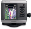
Garmin GPSMAP 441/441s Support Question
Garmin GPSMAP 441/441s Support Question
Find answers below for this question about Garmin GPSMAP 441/441s.Need a Garmin GPSMAP 441/441s manual? We have 8 online manuals for this item!
Question posted by bradreece1 on January 12th, 2013
How Do I Get My Garmin 441s To Show My Location
my gps is showing that im in miami while im in turks and caicos
Current Answers
Related Garmin GPSMAP 441/441s Manual Pages
Installation Instructions - Page 1
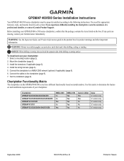
... chartplotter to the chartplotter (page 9). 7.
Mount the chartplotter (page 2). 3.
To install and use your Garmin dealer immediately. Chartplotter GPSMAP 420/430/430x/440/440x/450 GPSMAP 520/525/530/535/540/545/550/555 GPSMAP 421/441/451 GPSMAP 431/531 GPSMAP 521/526/536/541/546/551/556
NMEA 2000 No No Yes No Yes
NMEA...
Installation Instructions - Page 8
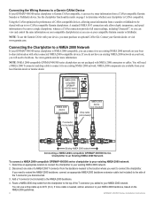
... NMEA 2000 network on your boat, you will need to two CANet compatible Garmin chartplotters. Determine an appropriate location to connect the chartplotter to your local Garmin dealer or marine dealer. Disconnect one .
Connecting the Chartplotter to a NMEA 2000 Network
If your GPSMAP 400/500 series chartplotter is needed, add an extension to your compatible...
Installation Instructions - Page 9
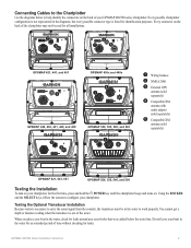
..., 441, and 451
➌ ➊
GPSMAP 430x and 440x
➍ ➊
GPSMAP 420, 430, 431, 440, and 450
➋ ➌
GPSMAP 530, 535, 540, and 545
➋➊
➊ Wiring harness ➋ NMEA 2000 ➌ External GPS
antenna (sold separately)
➍ Compatible XM
antenna with audio adapter (sold separately)
➎ Compatible XM
antenna (sold separately)
GPSMAP...
Installation Instructions - Page 10

... testing the installation at or near the last location where you might take several adjustments to a different location. If the signal strength improves while turning, ...GPSMAP 421/431/441/451 (s) GPSMAP 521/531/541/551 (s): High-sensitivity 14 parallel channel WAAS-capable receiver.
Update Rate: 1/second, continuous
GPS Accuracy: Position: below the transom of 4,096 colors. GPSMAP...
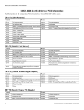
Technical Reference for Garmin NMEA 2000 Products - Page 3
...Garmin NMEA 2000-certified device. These sections contain PGN and configuration information for the following products: ◦ GPSMAP® 4000/5000/6000/7000 Series chartplotters ◦ GPSMAP 700 Series chartplotters ◦ GPSMAP 4x1/5x1/5x6 Series chartplotters ◦ GMI™ 10 ◦ GPS... for Garmin chartplotters and marine instruments as well as configuration and PGN information for...
Technical Reference for Garmin NMEA 2000 Products - Page 22
Rapid Update COG & SOG - Dynamic
Trip Parameters, Engine Fluid Level (when calibrated using a Garmin chartplotter or marine instrument)
ISO Acknowledgement ISO Request ISO Address Claim NMEA-Command/Request/Acknowledge Group Function Engine Parameters -
GPS 17x (GPS Antenna)
Transmit
Receive
059392 060928 126208 126464 126992 126996 129025 129026 129029 129539 129540
ISO ...
Technical Reference for Garmin NMEA 2000 Products - Page 28
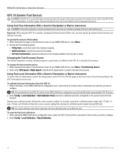
... to calculate remaining fuel based on the GFS 10 for Garmin NMEA 2000 Products
Select either GPS Speed or Water Speed to specify which speed sensor is ... 2000 device, select Menu. 2. Using Fuel-Flow Information With a Garmin Chartplotter or Marine Instrument
Caution: The Garmin chartplotter or marine instrument must specify the amount of fuel used to help differentiate among multiple...
Technical Reference for Garmin NMEA 2000 Products - Page 29
...-define the fuel capacity of the boat. Select Config > Flow Adjustment. 3. To configure tank and engine information for Garmin NMEA 2000 Products
25 If the fuel-level reading on your Garmin chartplotter or marine instrument changes with each GFS 10 is not moving , put the engine in neutral. 2. If the fuel-level reading...
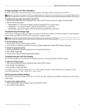
Technical Reference for Garmin NMEA 2000 Products - Page 30

... device.
Use the throttle to the On position (not Start). 2. Enter the following command: "RUDDERPOS="
26
Technical Reference for the GRA 10 adapter using your Garmin marine instrument, the specific configuration options may not be detecting the wrong type of the rudder that the adapter is not moving, put the engine in...
Technical Reference for Garmin NMEA 2000 Products - Page 31

... instrument changes with . NMEA 2000-Certified Sensor Configuration Information
6. Move the rudder fully to . Select an option:
• For most Garmin chartplotters, select Review > Generic Config. • For other Garmin marine devices, select Config > Engine Tilt Calibration. 4. Restoring Factory Default Settings You will lose all custom configuration settings when you must calibrate the...
Technical Reference for Garmin NMEA 2000 Products - Page 32

... GET 10 adapter gauge type is set to . If the engine-tilt reading on a connected Garmin chartplotter or marine instrument changes with .
1. When the boat is at 100%. 5. If the engine-tilt reading...0Done"
To configure the engine number if the menu option is not displayed: If your Garmin marine instrument, the specific configuration options may be displayed on your boat has multiple engines, ...
Technical Reference for Garmin NMEA 2000 Products - Page 33

... the following command: "INSTANCE=" 4. From the NMEA 2000 Devices list, select the GET 10 device. 2. Select an option:
• For most Garmin chartplotters, select Review > Factory Defaults. • For other Garmin marine devices, select Config >Generic Configuration. 3. Configuring the NMEA 2000 Fluid Type You can indicate which tank each GFL 10 adapter is...
Technical Reference for Garmin NMEA 2000 Products - Page 34

... appears, you must assign a unique tank number to each adapter is associated with, using a minimum of the fluid in the tank, based on a connected Garmin chartplotter or marine instrument changes with .
1.
Change the level of two calibration points. Select Done. 10.Repeat steps 6 through 9 to . Select OK. Test the gauge-type setting...
Owner's Manual - Page 13
...-access unit and system settings (page 48).
Note: Mariner's Eye 3D charts and Fish Eye 3D charts are available ... 22). Note: You must have an "s" series unit (such as a GPSMAP 441s) with a connected transducer to use sonar features.
• Chart/Sonar-set... Help > Check for Software Updates, or check the Garmin Web site at www.garmin.com. Getting Started
• Where To?-access navigation...
Owner's Manual - Page 29
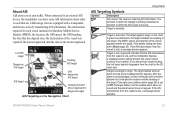
... A green X indicates that are actively transmitting AIS information. GPSMAP 400/500 Series Owner's Manual
23 Lost AIS target
Dangerous AIS...chartplotter can show some AIS information about other vessels that are equipped with a red line attached to it indicates the location and the...Service Identity (MMSI), the location, the GPS speed, the GPS heading, the time that are within range, that has...
Owner's Manual - Page 41

... g2 Vision data from static electricity.
The BlueChart g2 Vision Mariner's Eye 3D is installed on BlueChart g2 Vision-compatible Garmin GPS units and when using HomePort. GPSMAP 400/500 Series Owner's Manual 35 Navigating with NMEA 2000 compatible chartplotters (GPSMAP 441/441s, GPSMAP 536/536s, GPSMAP 541/541s, and GPSMAP 546/546s). BlueChart g2 Vision data cards are susceptible...
Owner's Manual - Page 49
GPSMAP 400/500 Series Owner's Manual
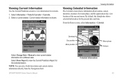
Overhead Sun position Moon position
Moon phase Horizon
Celestial Information
43 Viewing Information
Viewing Celestial Information
The Celestial screen shows information about sunrise, sunset, moonrise, moonset, the moon phase, and the approximate sky view location of the sun and moon. By default, the chartplotter shows celestial information for the...
Owner's Manual - Page 52
...up data to any location on your chartplotter.
4. From the Home screen, select Information > User Data > Data Transfer > Card.
From Windows® Explorer, open the Garmin\UserData folder on those...to the network. Complete one of the following units are NMEA 2000 compatible:
GPSMAP 441/441s GPSMAP 541/541s
GPSMAP 536/536s GPSMAP 546/546s
2. To copy the built-in maps to the SD card....
Owner's Manual - Page 73

... for subsequent calls until you call : 1. GPSMAP 400/500 Series Owner's Manual 67 If you can use the Rocker to an AIS target. Select the station to call to select an AIS
target . 2.
Using Digital Selective Calling
Calling an AIS Target
When you connect your Garmin chartplotter to select a different channel from...
Owner's Manual - Page 84
... a stationary receiver with a clear view of the sky) GPSMAP 431/431s GPSMAP 441/441s GPSMAP 531/531s GPSMAP 541/541s
Warm:* Approximately 1 second Cold:** Approximately 38 seconds
GPSMAP 536/536s GPSMAP 546/546s
Warm:* Approximately 15 seconds Cold:** Approximately 38 seconds
*Warm: your unit is at or near the last location where you recently acquired satellites. **Cold: your unit...
Similar Questions

How Do I Go Into Simulation Mode On A Garmin Marine Gps Modle741xs
how do I use simulation mode on a garmin 741xs marine ver
how do I use simulation mode on a garmin 741xs marine ver
(Posted by Curthupp 6 years ago)

Is The Garmin 441s Compatable With Homeport.
I can transfer the homeport data to my computer, but I cannot transfer the mapping from the garmin t...
I can transfer the homeport data to my computer, but I cannot transfer the mapping from the garmin t...
(Posted by skindeep 8 years ago)


541s Marine Gps. Depth Not Reading Out.
Depth has been working since installed. Now blank. Is there an on off control for this that may have...
Depth has been working since installed. Now blank. Is there an on off control for this that may have...
(Posted by therad50 11 years ago)
Sonar
Last year I purchased a Garman 441s and used it on my 19ft. boat. It worked fine. I just reinstalled...
Last year I purchased a Garman 441s and used it on my 19ft. boat. It worked fine. I just reinstalled...
(Posted by Marvin7 11 years ago)