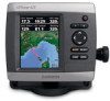
Garmin GPSMAP 421/421s Support Question
Garmin GPSMAP 421/421s Support Question
Find answers below for this question about Garmin GPSMAP 421/421s.Need a Garmin GPSMAP 421/421s manual? We have 8 online manuals for this item!
Question posted by rashidhinai0 on December 23rd, 2021
Gps Block Diagram
can i have the GPS block diagram for learjet aircraft
Current Answers
Answer #1: Posted by SonuKumar on December 24th, 2021 8:53 AM
SonuKumar

Member since:
May 9th, 2021 Points: 16,609,800

Member since:
May 9th, 2021 Points: 16,609,800
Please respond to my effort to provide you with the best possible solution by using the "Acceptable Solution" and/or the "Helpful" buttons when the answer has proven to be helpful.
Regards,
Sonu
Your search handyman for all e-support needs!!
Related Garmin GPSMAP 421/421s Manual Pages
Installation Instructions - Page 1
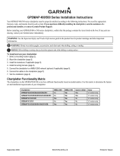
... 3). 4.
Warning: Always wear safety goggles, ear protection, and a dust mask when drilling, cutting, or sanding.
Chartplotter GPSMAP 420/430/430x/440/440x/450 GPSMAP 520/525/530/535/540/545/550/555 GPSMAP 421/441/451 GPSMAP 431/531 GPSMAP 521/526/536/541/546/551/556
NMEA 2000 No No Yes No Yes
NMEA 0183...
Installation Instructions - Page 6
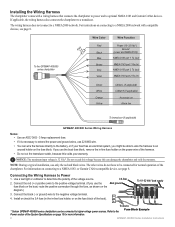
...GPSMAP 400/500 series chartplotters can be connected to higher-voltage power sources.
Notice: The maximum input voltage is necessary to extend the power and ground wires, use the boat fuse block, remove the in-line fuse holder on the diagram...compatible devices, see page 8. For instructions on the fuse block. To the GPSMAP 400/500 series chartplotter
3FAuse
Wire Color
Red
Black
>
...
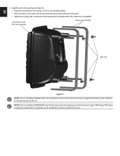
Installation Instructions - Page 9
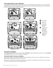
Connecting Cables to the Chartplotter
Use the diagrams below the water line. Testing the Optional Transducer Installation Because water is necessary to carry the sonar signal from the sounder, the transducer must be used for all installations.
➋ ➌
➌ ➊➎
GPSMAP 421, 441, and 451
➌ ➊
GPSMAP 430x and 440x
➍ ➊...
Installation Instructions - Page 10

...to 55ºC)
Compass-Safe Distances:
Model Number
GPSMAP 526/536/546/556 GPSMAP 421/431/441/451 GPSMAP 521/531/541/551 GPSMAP 420/430/440/450 GPSMAP 520/530/540/550/525/535/545/555
... continuous
GPS Accuracy: Position: If the sonar signal suddenly is lost . Caution: When adjusting the depth of the boat. Temp.
GPSMAP 520/521/530/531/540/541/550/551 (s): 5.0 in small increments. GPSMAP 526...
Technical Reference for Garmin NMEA 2000 Products - Page 3
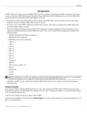
... two sections provide Parameter Group Number (PGN) information for Garmin chartplotters and marine instruments as well as configuration and PGN information for in-country support information,...products: ◦ GPSMAP® 4000/5000/6000/7000 Series chartplotters ◦ GPSMAP 700 Series chartplotters ◦ GPSMAP 4x1/5x1/5x6 Series chartplotters ◦ GMI™ 10 ◦ GPS 17x ◦ ...
Technical Reference for Garmin NMEA 2000 Products - Page 4
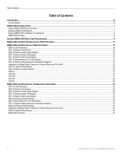
...Requirements...9
NMEA 2000-Certified Display Device PGN Information...13
NMEA 2000-Certified Sensor PGN Information...18 GPS 17x (GPS Antenna)...18 GFS 10 (Garmin Fuel Sensor)...18 GRA 10 (Garmin Rudder Angle Adapter)...18 ...Depth Transducer-Transom Mount and Thru-Hull)...19 GWS 10 (Garmin Wind Sensor)...20 GHP 10 (Marine Autopilot System)...20 GXM 51...21 VHF 200...21 VHF 300...21 AIS 300...22 AIS ...
Technical Reference for Garmin NMEA 2000 Products - Page 13
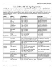
...Eng Dynamic 127488 - Engine Rapid 127245 - Small Craft Status 130576 - Route 129284 - Eng Dynamic (GPS Speed or Water Speed) Note: The Fuel Economy data type is necessary or a specific combination of ... the NMEA 2000-certified display devices (such as a GPSMAP 4000/5000 series chartplotter or a GMI 10) on the NMEA 2000 network. Eng Dynamic (GPS Speed or Water Speed) 127505 - Route 129284 - ...
Technical Reference for Garmin NMEA 2000 Products - Page 22
... 127489 127497 127505
127505
Fluid Level (when calibrated using a Garmin chartplotter or marine instrument)
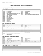
GRA 10 (Garmin Rudder Angle Adapter)
Transmit
Receive
059392
ISO Acknowledgment
...Product Information
127245
Rudder
ISO Acknowledgment ISO Request ISO Address Claim NMEA - GPS 17x (GPS Antenna)
Transmit
Receive
059392 060928 126208 126464 126992 126996 129025 129026 129029...
Technical Reference for Garmin NMEA 2000 Products - Page 28
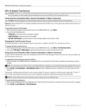
... GFS 10, to calculate fuel economy. Using Fuel-Level Information With a Garmin Chartplotter or Marine Instrument To receive fuel-level information, connect the wiring harness on the NMEA 2000 device configuration...10 to calculate remaining fuel based on your NMEA 2000 device, select Menu. 2.
Select either GPS Speed or Water Speed to specify which speed sensor is used on the fuel-flow rate, ...
Flush Mount Kit Instructions (Multilingual) - Page 2
NOTE: If you are installing a GPSMAP 400 series unit, you are installing a Fishfinder 400C, the wiring harness must connect the wiring harness to the boat's power supply, GPS antenna, XM antenna (if applicable), and transducer (if applicable) per the installation instructions included with the unit. EN
3. Install the unit in the opening (see...
Important Safety and Product Information - Page 2
...unit only as a waste electronics treatment facility, to have the battery removed and recycled.
Battery Warnings Your GPS unit may use of direction, distance, location,
or topography.
• If your unit has video input ... if your boat. Official government charts and notices to mariners contain all information needed to navigate safely.
• Use this product, see www.erecycle.org.
Owner's Manual - Page 3
... GPSMAP 400/500 Series Owner's Manual Introduction
This manual includes information for the following products:
GPSMAP® 421/421s GPSMAP 521/521s GPSMAP 551/551s
GPSMAP 451/451s GPSMAP 526/526s GPSMAP .... Introduction
Quick Links
• Turning the Unit On or Off: page 2. • Acquiring GPS Satellite Signals: page 5. • Inserting and Removing SD Cards: page 6. • Restoring ...
Owner's Manual - Page 4
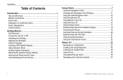
...or Off 2 Initializing Unit Settings 2 Adjusting the Backlight 3 Using the Keypad 4 Acquiring GPS Satellite Signals 4 Using Simulator Mode 5 Viewing System Information 5 Restoring the Original Factory Settings ... 11 Using the Split Navigation Chart 14 Using Perspective 3D 14 Using Mariner's Eye 3D 15 Using Fish Eye 3D 17 Using Fishing Charts 17...GPSMAP 400/500 Series Owner's Manual
Owner's Manual - Page 7

Unit Overview
GPSMAP 526/556
Getting Started
NMEA 2000®
Power/Data
External GPS antenna
GPSMAP 421/451/ 521/551
Power/Data
NMEA 2000®
GPSMAP 400/500 Series Owner's Manual
External GPS antenna
Getting Started
POWER/ BACKLIGHT RANGE (-/+) ROCKER MARK SELECT MENU HOME
SD card slot GPSMAP 526 shown
Owner's Manual - Page 13
...
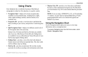
Use the Navigation chart to view map information, and as a three-dimensional navigation aid.
Using Charts
• Mariner's Eye 3D-provides a view from the Home screen, select Charts > Navigation Chart. Fishing charts are using a GPSMAP 421, 521, or 526 (including "s" models), you use a BlueChart g2 Vision SD card. Note: If you are available...
Owner's Manual - Page 36
...resolution satellite images for a three-dimensional navigation aid.
The BlueChart g2 Vision Mariner's Eye 3D is more detailed than the preloaded data (page 15).
... When you should ground yourself on BlueChart g2 Vision-compatible Garmin GPS units. Note: You cannot transfer BlueChart g2 Vision data from exposure...GPSMAP 400/500 Series Owner's Manual In low-humidity environments, you are...
Owner's Manual - Page 51

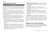
...safe-zone collision alarm settings are applied to all 3D chart views.
1. GPSMAP 400/500 Series Owner's Manual
45 Fishing charts are available only if ... g2 Vision SD card. Select Navigation Chart, Fishing Chart, Perspective 3D, or
Mariner's Eye 3D. 3.
Use the Rocker to all charts and to select an ..., MMSI, GPS speed, GPS heading, and other information that appears using a trail. From the Home...
Owner's Manual - Page 73
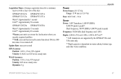
Update Rate: once per second
GPS Accuracy: Position: Acquisition Times: (Average acquisition times for a stationary receiver with a clear view of the sky)
GPSMAP 421/421s GPSMAP 451/451s GPSMAP 521/521s GPSMAP 551/551s
Warm*: Approximately 1 second Cold**: Approximately 38 seconds
GPSMAP 526/526s GPSMAP 556/556s
Warm*: Approximately 15 seconds Cold**: Approximately 45 seconds
*Warm: your unit is...
Owner's Manual - Page 79
...52 clock 52 collision 55 deep water 53 engine gauge 33 fish 53 fuel 53 GPS accuracy 52 navigation 52 off course 52 safe-zone 55 shallow water 53 sonar 53...
using 22 Chart Borders 13 chart data 9
charts detail 12 fish eye 3D 17 fishing 17 mariner's eye 3D 15 navigation 7 settings 11
Clear User Data 39 collision alarm 55 colors, hazard...contact 62 list 62 DST 48
GPSMAP 400/500 Series Owner's Manual 73
Owner's Manual - Page 80
... sonar 56 fuse 67
G
gain 60 Garmin Data Transfer 50 go to 23 GPS 4, 47, 67 GPS heading 37 Grid (North) 48
74
grid coordinates creating waypoints using 25
ground... heading 37 Man Overboard 25, 63 Manual Zoom 60 map datum 48 MapSource data 39 mariner's eye 3D 15
colors 16 mark current location 25 measuring distance 26 MENU key 4 ...source 67 product registration iv
GPSMAP 400/500 Series Owner's Manual
Similar Questions

I Have To Reset My Gps Map 421
all of a sudden my gps won't work. all I see is Garmin logo. what do I have to do to reset/open my g...
all of a sudden my gps won't work. all I see is Garmin logo. what do I have to do to reset/open my g...
(Posted by hugodoenjar 3 years ago)

Not Acquiring Satellite Garmin Gps 78
What do i do if my Garmin GPS 78 does not acquire any sattelites?
What do i do if my Garmin GPS 78 does not acquire any sattelites?
(Posted by vitawyler 7 years ago)
Garmin Gpsmap 492 How To Set The Gps Accuracy Alarm In A 429gpsmap.
I have Garmin gpsmap 492 chartplotter and I can't find the system sub tab to adjust the GPS Accuracy...
I have Garmin gpsmap 492 chartplotter and I can't find the system sub tab to adjust the GPS Accuracy...
(Posted by bamajo2 8 years ago)

Block Diagram Of Garmin 421s Gps
Hi Sir I want the Block Diagram Of ((garmin 421s gps)),but I couldn't find such as this? please hel...
Hi Sir I want the Block Diagram Of ((garmin 421s gps)),but I couldn't find such as this? please hel...
(Posted by fsanatdarya 10 years ago)

Instruction Video For My Gps Map 478 Garmin.
I am looking for an instruction video for my GPS Map 478 Garmin Marine.
I am looking for an instruction video for my GPS Map 478 Garmin Marine.
(Posted by bobkogon 11 years ago)