Manual - English
Page 2
...States copyright laws and international treaty provisions; USE GOOD JUDGEMENT This product is protected by the U.S. USE CARE The Global Positioning System (GPS) is dangerous and can also be affected by the periodic adjustments to a complete stop or have a passenger make any purpose other...use , copy, modify, reverse engineer or transfer this guide may severely degrade performance or damage the receiver, and will void the warranty. Never rely solely on the Magellan eXplorist while driving. The SOFTWARE is solely responsible for any changes. All rights not expressly granted are ...
...States copyright laws and international treaty provisions; USE GOOD JUDGEMENT This product is protected by the U.S. USE CARE The Global Positioning System (GPS) is dangerous and can also be affected by the periodic adjustments to a complete stop or have a passenger make any purpose other...use , copy, modify, reverse engineer or transfer this guide may severely degrade performance or damage the receiver, and will void the warranty. Never rely solely on the Magellan eXplorist while driving. The SOFTWARE is solely responsible for any changes. All rights not expressly granted are ...
Manual - English
Page 4
... of Contents eXplorist 210 GPS Receiver Features of the Magellan eXplorist GPS receiver: Button Descriptions: Installing the Battery Using the eXplorist 210 Going to a Destination Saving Your Position Tracing Your Steps Additional Features Starting Up Turning the eXplorist On Turning the eXplorist Off Using the eXplorist for the ... Fields Position Screen Overview Position Screen Satellite Status Screen Satellite Status Screen Overview Resetting the Trip Odometer eXplorist 210 GPS File Structure Basic File Structure File Structure Overview Using the Filing System with POIs Using the Filing ...
... of Contents eXplorist 210 GPS Receiver Features of the Magellan eXplorist GPS receiver: Button Descriptions: Installing the Battery Using the eXplorist 210 Going to a Destination Saving Your Position Tracing Your Steps Additional Features Starting Up Turning the eXplorist On Turning the eXplorist Off Using the eXplorist for the ... Fields Position Screen Overview Position Screen Satellite Status Screen Satellite Status Screen Overview Resetting the Trip Odometer eXplorist 210 GPS File Structure Basic File Structure File Structure Overview Using the Filing System with POIs Using the Filing ...

Manual - English
Page 6
... Files on the Personal Computer Magellan Geocache Manager Magellan Geocache Manager What is Geocaching? Overview of Uploading Detail Maps from MapSend to the eXplorist Transferring POIs, Routes, and Tracks to MapSend Transferring POIs, Routes, and Track Between MapSend and eXplorist Transferring Waypoints, Routes, and Tracks from MapSend Preferences Restarting the GPS Changing the Default Folders...
... Files on the Personal Computer Magellan Geocache Manager Magellan Geocache Manager What is Geocaching? Overview of Uploading Detail Maps from MapSend to the eXplorist Transferring POIs, Routes, and Tracks to MapSend Transferring POIs, Routes, and Track Between MapSend and eXplorist Transferring Waypoints, Routes, and Tracks from MapSend Preferences Restarting the GPS Changing the Default Folders...
Manual - English
Page 8
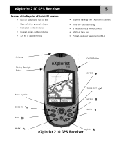
eXplorist 210 GPS Receiver Features of the Magellan eXplorist GPS receiver: • Built-in background map (8 MB) • High-definition grayscale display • Preloaded points of interest • Rugged design, rubber-protected • 22 MB of usable memory 5 • Superior tracking with 14 parallel channels • TrueFix™ GPS technology • 3 meter accuracy (WAAS/EGNOS) • Multiple track logs •...
eXplorist 210 GPS Receiver Features of the Magellan eXplorist GPS receiver: • Built-in background map (8 MB) • High-definition grayscale display • Preloaded points of interest • Rugged design, rubber-protected • 22 MB of usable memory 5 • Superior tracking with 14 parallel channels • TrueFix™ GPS technology • 3 meter accuracy (WAAS/EGNOS) • Multiple track logs •...
Manual - English
Page 9
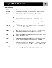
... displayed. Also used to quickly step through the list of POIs when doing an alphabetical search. Steps through the navigation screens. eXplorist 210 GPS Receiver 6 Button Descriptions: On/Off Backlight ENTER Turns the eXplorist on or off to low to high intensity. Steps backwards through the navigation screens. (Map screen > Compass screen > Position screen > Satellite...
... displayed. Also used to quickly step through the list of POIs when doing an alphabetical search. Steps through the navigation screens. eXplorist 210 GPS Receiver 6 Button Descriptions: On/Off Backlight ENTER Turns the eXplorist on or off to low to high intensity. Steps backwards through the navigation screens. (Map screen > Compass screen > Position screen > Satellite...

Manual - English
Page 10
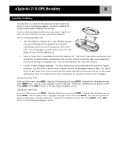
eXplorist 210 GPS Receiver Wrist Lanyard Strap Mounting Hole Battery Door 7 Connector for external power and connection to install batteries.) eXplorist 210 GPS Receiver (back) Battery Door Fastener (Unscrew to open battery door to a personal computer.
eXplorist 210 GPS Receiver Wrist Lanyard Strap Mounting Hole Battery Door 7 Connector for external power and connection to install batteries.) eXplorist 210 GPS Receiver (back) Battery Door Fastener (Unscrew to open battery door to a personal computer.
Manual - English
Page 11
... of the buttons have been pressed and you to set a time interval that the display backlight will automatically turn to automatically turn the eXplorist off. Use the arrow joystick to the last viewed navigation screen. Use the down arrow to select 30 Seconds, 1 Minute, 2 ... press MENU. Press NAV to return to observe the proper polarity when installing the batteries. eXplorist 210 GPS Receiver 8 Installing the Battery The eXplorist 210 uses two AA batteries that are not moving or standing still, the eXplorist is the use . Be sure to the last viewed navigation screen.
... of the buttons have been pressed and you to set a time interval that the display backlight will automatically turn to automatically turn the eXplorist off. Use the arrow joystick to the last viewed navigation screen. Use the down arrow to select 30 Seconds, 1 Minute, 2 ... press MENU. Press NAV to return to observe the proper polarity when installing the batteries. eXplorist 210 GPS Receiver 8 Installing the Battery The eXplorist 210 uses two AA batteries that are not moving or standing still, the eXplorist is the use . Be sure to the last viewed navigation screen.

Manual - English
Page 12
...select the "Explore" option. There are able to copy files to and from the eXplorist to external power using the external AC power adapter. From here you connect the eXplorist to your computer. Turn your personal computer on and then turn on the desktop of ... is recommended that it to the back of your eXplorist and tighten the locking screw. eXplorist 210 GPS Receiver 9 Connecting to a Personal Computer (requires optional USB cable) Turn your eXplorist off and connect the round connector of the eXplorist data cable to the eXplorist first before plugging the AC power adapter into a...
...select the "Explore" option. There are able to copy files to and from the eXplorist to external power using the external AC power adapter. From here you connect the eXplorist to your computer. Turn your personal computer on and then turn on the desktop of ... is recommended that it to the back of your eXplorist and tighten the locking screw. eXplorist 210 GPS Receiver 9 Connecting to a Personal Computer (requires optional USB cable) Turn your eXplorist off and connect the round connector of the eXplorist data cable to the eXplorist first before plugging the AC power adapter into a...

Manual - English
Page 13
... obstructions (such as a straight line from where you find that it can receive the signals from the satellites. A computed position with only three satellites is the foundation that your eXplorist will be to provide you 'll need to arrive at least four satellites with...antenna with the navigation tools you with your position. Positions that has a better view of your present position. Using the eXplorist 210 10 The eXplorist 210 uses information from the GPS satellites orbiting the earth to the Satellite Status screen. Do: • Point the antenna up towards the sky. &#...
... obstructions (such as a straight line from where you find that it can receive the signals from the satellites. A computed position with only three satellites is the foundation that your eXplorist will be to provide you 'll need to arrive at least four satellites with...antenna with the navigation tools you with your position. Positions that has a better view of your present position. Using the eXplorist 210 10 The eXplorist 210 uses information from the GPS satellites orbiting the earth to the Satellite Status screen. Do: • Point the antenna up towards the sky. &#...

Manual - English
Page 29
... screen: • With an active route, the top of the Compass screen displays the name of the destination if you must be familiar to most GPS users.
... screen: • With an active route, the top of the Compass screen displays the name of the destination if you must be familiar to most GPS users.

Manual - English
Page 31
...Battery life indicator Position Screen Overview Coordinates of present position Elevation of present position Trip Odometer Accuracy of the AA batteries in the eXplorist. Highlights of the Position screen: • Position is displayed in textual format using WAAS information to increase the accuracy of the... position fix. • Date and time are shown, automatically adjusted from time information supplied from the atomic clocks in the GPS satellites. • A resettable trip odometer to keep track of the distance you've travelled. • A graphical battery indicator provides ...
...Battery life indicator Position Screen Overview Coordinates of present position Elevation of present position Trip Odometer Accuracy of the AA batteries in the eXplorist. Highlights of the Position screen: • Position is displayed in textual format using WAAS information to increase the accuracy of the... position fix. • Date and time are shown, automatically adjusted from time information supplied from the atomic clocks in the GPS satellites. • A resettable trip odometer to keep track of the distance you've travelled. • A graphical battery indicator provides ...
Manual - English
Page 33
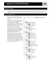
It is based on a GPS receiver. This will make finding the POI or route much easier when you should do so to a copy of the file. File Structure Overview This graphic ... empty until you can cause unwanted results. If you are probably familiar with from the Magellan Geocaching software. eXplorist 210 GPS File Structure 30 Basic File Structure The eXplorist has a file structure system that is internal to the eXplorist. When your eXplorist is connected to your personal computer, you upload a detailed map from mapping software, such as...
It is based on a GPS receiver. This will make finding the POI or route much easier when you should do so to a copy of the file. File Structure Overview This graphic ... empty until you can cause unwanted results. If you are probably familiar with from the Magellan Geocaching software. eXplorist 210 GPS File Structure 30 Basic File Structure The eXplorist has a file structure system that is internal to the eXplorist. When your eXplorist is connected to your personal computer, you upload a detailed map from mapping software, such as...

Manual - English
Page 34
...; Creating new Folders: You can add a route. Use the displayed keyboard to enter a name for the folder. eXplorist 210 GPS File Structure 31 Using the Filing System with Routes • When retrieving or saving a route, the eXplorist automatically goes to the default route file where the route will be found or saved. Use the...
...; Creating new Folders: You can add a route. Use the displayed keyboard to enter a name for the folder. eXplorist 210 GPS File Structure 31 Using the Filing System with Routes • When retrieving or saving a route, the eXplorist automatically goes to the default route file where the route will be found or saved. Use the...

Manual - English
Page 35
...to be saved in. Press ENTER to highlight Active Track and press ENTER. When the name is correct, highlight OK and press ENTER. eXplorist 210 GPS File Structure 32 Using the Filing System with Track Logs • Track logs are saved differently from POIs and routes in here and ...press ENTER. The eXplorist automatically accesses the internal Tracklog folder. • Creating a new Track Log File: Use the Arrow joystick to access this manual, instructions will...
...to be saved in. Press ENTER to highlight Active Track and press ENTER. When the name is correct, highlight OK and press ENTER. eXplorist 210 GPS File Structure 32 Using the Filing System with Track Logs • Track logs are saved differently from POIs and routes in here and ...press ENTER. The eXplorist automatically accesses the internal Tracklog folder. • Creating a new Track Log File: Use the Arrow joystick to access this manual, instructions will...
Manual - English
Page 36
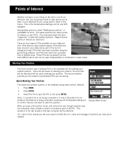
...The second method provides you the means to the database will notice that even though elevation was computed by the eXplorist. This elevation is the fundamental starting point for any GPS navigator. Waypoints and points of interest are identical.) There are going to want to save a 2D position fix ...and can go back to describe marked positions. Points of Interest 33 Whether driving in a car, hiking on the trail or out for an afternoon sail, you are four types of POIs available for your eXplorist 210: POIs that you have marked (saved), POIs that have been stored in your...
...The second method provides you the means to the database will notice that even though elevation was computed by the eXplorist. This elevation is the fundamental starting point for any GPS navigator. Waypoints and points of interest are identical.) There are going to want to save a 2D position fix ...and can go back to describe marked positions. Points of Interest 33 Whether driving in a car, hiking on the trail or out for an afternoon sail, you are four types of POIs available for your eXplorist 210: POIs that you have marked (saved), POIs that have been stored in your...

Manual - English
Page 47
... selecting the destination POI from the POI database. • GOTO routes can not be saved. • GOTO routes are erased when the eXplorist is a backtrack route. (The creation of a GPS receiver. Features of a GOTO route: • A straight line from your present position to a selected POI. • GOTO routes can also be a single leg...
... selecting the destination POI from the POI database. • GOTO routes can not be saved. • GOTO routes are erased when the eXplorist is a backtrack route. (The creation of a GPS receiver. Features of a GOTO route: • A straight line from your present position to a selected POI. • GOTO routes can also be a single leg...
Manual - English
Page 68
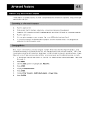
... Data Comm mode outputs the GPS data from the eXplorist and the personal computer. If the eXplorist has just been turned on the back of the USB ports on the PC interface cable to and from the eXplorist in . Press MENU. 3. Highlight Communications. 6. Press ENTER. 7. Turn the eXplorist on your eXplorist connected to a personal computer through...
... Data Comm mode outputs the GPS data from the eXplorist and the personal computer. If the eXplorist has just been turned on the back of the USB ports on the PC interface cable to and from the eXplorist in . Press MENU. 3. Highlight Communications. 6. Press ENTER. 7. Turn the eXplorist on your eXplorist connected to a personal computer through...
Manual - English
Page 75
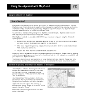
... routes, map regions, etc. • Plug and play in the eXplorist, but are interested in and pan until you purchased, the first step is the Magellan line of detailed digital maps for your eXplorist. Overview of the detailed maps available for Magellan hand-held GPS receivers. Using the Draw New Region tool, define the region. In... details on -line www.magellangps.com under Products > Maps and Software. The core MapSend product line includes street maps for driving, topographic maps for hiking, camping, and hunting, and fresh/salt water maps for outdoor recreation and travel.
... routes, map regions, etc. • Plug and play in the eXplorist, but are interested in and pan until you purchased, the first step is the Magellan line of detailed digital maps for your eXplorist. Overview of the detailed maps available for Magellan hand-held GPS receivers. Using the Draw New Region tool, define the region. In... details on -line www.magellangps.com under Products > Maps and Software. The core MapSend product line includes street maps for driving, topographic maps for hiking, camping, and hunting, and fresh/salt water maps for outdoor recreation and travel.
Manual - English
Page 76
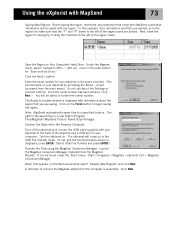
... begin saving the region. It can be saved with your eXplorist by clicking the checkbox to GPS..." (Ctrl+U). A reminder to connect the Magellan eXplorist to the saved files is presented. Before saving the region, review the documentation that came with MapSend ... Product Name'\Export\Images. This can be asked to the left of the eXplorist and a USB port on Hard Drive." Connect the eXplorist to Update window is displayed, press ENTER. Start > Programs > Magellan > eXplorist 210 > Magellan Conversion Manager. Click Next. Next, mark the region for saving by accessing the ...
... begin saving the region. It can be saved with your eXplorist by clicking the checkbox to GPS..." (Ctrl+U). A reminder to connect the Magellan eXplorist to the saved files is presented. Before saving the region, review the documentation that came with MapSend ... Product Name'\Export\Images. This can be asked to the left of the eXplorist and a USB port on Hard Drive." Connect the eXplorist to Update window is displayed, press ENTER. Start > Programs > Magellan > eXplorist 210 > Magellan Conversion Manager. Click Next. Next, mark the region for saving by accessing the ...
Manual - English
Page 78
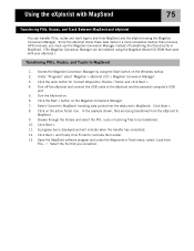
... of transferring the files directly in a more accessible manner than previous GPS receivers, you converted. Select 'Convert to MapSend' (sending data points from File...". Under "Programs" select 'Magellan > eXplorist 210 > Magellan Conversion Manager'. 3. Click on the Magellan Conversion Manager. 7. Click Next > and finally click Finish to the eXplorist and the personal computer's USB port. 5. Click the Next > button...
... of transferring the files directly in a more accessible manner than previous GPS receivers, you converted. Select 'Convert to MapSend' (sending data points from File...". Under "Programs" select 'Magellan > eXplorist 210 > Magellan Conversion Manager'. 3. Click on the Magellan Conversion Manager. 7. Click Next > and finally click Finish to the eXplorist and the personal computer's USB port. 5. Click the Next > button...


