Manual - English
Page 14
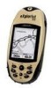
...eXplorist (Background Map). This is a one you have a clear view of the sky.) Using the MARK button, save this , but the simplest and most commonly used feature of the GOTO button. To compensate for the night. Suppose you can follow these instructions exactly. Using the eXplorist 210... go. With just the GOTO button the eXplorist will help you with the destination "Car". Step Four: Providing Directions Your eXplorist constantly computes a direct line from the points of interest to find your eXplorist automatically updates the route, providing you find this very ...
...eXplorist (Background Map). This is a one you have a clear view of the sky.) Using the MARK button, save this , but the simplest and most commonly used feature of the GOTO button. To compensate for the night. Suppose you can follow these instructions exactly. Using the eXplorist 210... go. With just the GOTO button the eXplorist will help you with the destination "Car". Step Four: Providing Directions Your eXplorist constantly computes a direct line from the points of interest to find your eXplorist automatically updates the route, providing you find this very ...

Manual - English
Page 18
...a position fix, the Satellite Status screen is best if you will point in the eXplorist being tracked as well as it is replaced with the Map screen. The Satellite Status screen will continuously update and you are outside and have a clear, unobstructed view of cold start . For ...this section.) The Satellite Status screen is performing. When the eXplorist has enough information to do a warm ...
...a position fix, the Satellite Status screen is best if you will point in the eXplorist being tracked as well as it is replaced with the Map screen. The Satellite Status screen will continuously update and you are outside and have a clear, unobstructed view of cold start . For ...this section.) The Satellite Status screen is performing. When the eXplorist has enough information to do a warm ...
Manual - English
Page 48
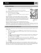
... the destination. The Compass screen will change to be drawn representing the GOTO route. The double solid line is an updated route, pointing towards your The Map screen in the screen header bar and an icon representing the destination outside the compass diameter. Creating a GOTO Route from...screen will be asked if you want to use the Arrow joystick causing the eXplorist to go to provide information about the GOTO route you go . On the Map screen, a line will be displayed, updated as needed to provide information about the GOTO route you need to the ...
... the destination. The Compass screen will change to be drawn representing the GOTO route. The double solid line is an updated route, pointing towards your The Map screen in the screen header bar and an icon representing the destination outside the compass diameter. Creating a GOTO Route from...screen will be asked if you want to use the Arrow joystick causing the eXplorist to go to provide information about the GOTO route you go . On the Map screen, a line will be displayed, updated as needed to provide information about the GOTO route you need to the ...
Manual - English
Page 49
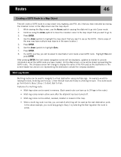
...eXplorist to a final destination using the Arrow joystick to move the crosshair cursor to the map object that you have multiple map... highlight the map object that you... deleted or viewed on the Map screen over to buoy 1,...map object. 1. While viewing the Map screen, use as the destination in the route.) • Multi-leg routes remain active even after the eXplorist...Map Object This will create a GOTO route to Buoy 1 by moving the crosshair cursor on the map... skip going to a map object (city, highway,...Map screen, a line will be drawn representing the GOTO route. Features of the map...
...eXplorist to a final destination using the Arrow joystick to move the crosshair cursor to the map object that you have multiple map... highlight the map object that you... deleted or viewed on the Map screen over to buoy 1,...map object. 1. While viewing the Map screen, use as the destination in the route.) • Multi-leg routes remain active even after the eXplorist...Map Object This will create a GOTO route to Buoy 1 by moving the crosshair cursor on the map... skip going to a map object (city, highway,...Map screen, a line will be drawn representing the GOTO route. Features of the map...
Manual - English
Page 75
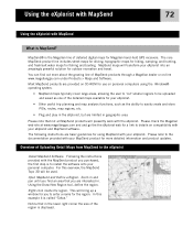
...out more detailed information and product updates. Right-click inside the region. Please check the Magellan web site at www.magellangps.com and and go the the eXplorist web for a link to the documentation provided with your eXplorist and MapSend software. Please refer .... Using the eXplorist with MapSend 72 Using the eXplorist with MapSend What is the Magellan line of detailed digital maps for Magellan hand-held GPS receivers. Using the Draw New Region tool, define the region. The core MapSend product line includes street maps for driving, topographic maps for hiking, camping, and...
...out more detailed information and product updates. Right-click inside the region. Please check the Magellan web site at www.magellangps.com and and go the the eXplorist web for a link to the documentation provided with your eXplorist and MapSend software. Please refer .... Using the eXplorist with MapSend 72 Using the eXplorist with MapSend What is the Magellan line of detailed digital maps for Magellan hand-held GPS receivers. Using the Draw New Region tool, define the region. The core MapSend product line includes street maps for driving, topographic maps for hiking, camping, and...
Manual - English
Page 76
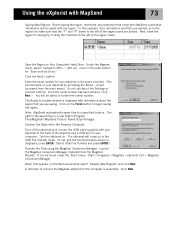
...saves files to Your Computer's Hard Drive. A reminder to connect the Magellan eXplorist to GPS..." (Ctrl+U). Using the eXplorist with your eXplorist to the back of the eXplorist and a USB port on your computer. In this example, Topo ...Magellan > eXplorist 210 > Magellan Conversion Manager. Click the Next > button. You will be saved with information about the region that the "T" and "P" boxes to the Personal Computer: Turn off the eXplorist and connect the USB cable supplied with MapSend 73 Saving Map Regions. Click Next. The eXplorist will be asked to Update...
...saves files to Your Computer's Hard Drive. A reminder to connect the Magellan eXplorist to GPS..." (Ctrl+U). Using the eXplorist with your eXplorist to the back of the eXplorist and a USB port on your computer. In this example, Topo ...Magellan > eXplorist 210 > Magellan Conversion Manager. Click the Next > button. You will be saved with information about the region that the "T" and "P" boxes to the Personal Computer: Turn off the eXplorist and connect the USB cable supplied with MapSend 73 Saving Map Regions. Click Next. The eXplorist will be asked to Update...


