Manual - English
Page 4
... Contents eXplorist 210 GPS Receiver Features of the Magellan eXplorist GPS receiver: Button Descriptions: Installing the Battery Using the eXplorist 210 Going to a Destination Saving Your Position Tracing Your Steps Additional Features Starting Up Turning the eXplorist On Turning the eXplorist Off Using the eXplorist for the First Time Turning the Display Backlight On/Off Conclusion Navigation Screens Accessing the Navigation Screens Map Screen Map...
... Contents eXplorist 210 GPS Receiver Features of the Magellan eXplorist GPS receiver: Button Descriptions: Installing the Battery Using the eXplorist 210 Going to a Destination Saving Your Position Tracing Your Steps Additional Features Starting Up Turning the eXplorist On Turning the eXplorist Off Using the eXplorist for the First Time Turning the Display Backlight On/Off Conclusion Navigation Screens Accessing the Navigation Screens Map Screen Map...
Manual - English
Page 6
...Routes, and Track Between MapSend and eXplorist Transferring Waypoints, Routes, and Tracks from MapSend Preferences Restarting the GPS Changing the Default Folders Using Active Setup Setting the Map Units Selecting Navigational Units of Measure Selecting the Background or Detail Map Selecting the Coordinate System Selecting the ...75 75 76 77 77 80 80 81 81 81 82 82 83 83 83 What is the Magellan Geocache Manager? Overview of Uploading Detail Maps from MapSend to the eXplorist Transferring POIs, Routes, and Tracks to a Personal Computer Changing Modes Communicating with a Personal Computer ...
...Routes, and Track Between MapSend and eXplorist Transferring Waypoints, Routes, and Tracks from MapSend Preferences Restarting the GPS Changing the Default Folders Using Active Setup Setting the Map Units Selecting Navigational Units of Measure Selecting the Background or Detail Map Selecting the Coordinate System Selecting the ...75 75 76 77 77 80 80 81 81 81 82 82 83 83 83 What is the Magellan Geocache Manager? Overview of Uploading Detail Maps from MapSend to the eXplorist Transferring POIs, Routes, and Tracks to a Personal Computer Changing Modes Communicating with a Personal Computer ...
Manual - English
Page 24
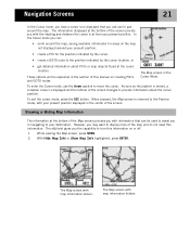
...on creating POI's and GOTO routes. However, you in the Cursor Mode. The eXplorist gives you the capability to display more of the screen provide you can : • scroll around the map, seeing available information for the position indicated by the cursor, • create a...location, or • get detailed information about the cursor position. The Map screen with map information shown. To exit the cursor mode, press the ESC button. While viewing the Map screen, press MENU. 2. The Map screen with map information hidden. When pressed, the Map screen is displayed and the...
...on creating POI's and GOTO routes. However, you in the Cursor Mode. The eXplorist gives you the capability to display more of the screen provide you can : • scroll around the map, seeing available information for the position indicated by the cursor, • create a...location, or • get detailed information about the cursor position. The Map screen with map information shown. To exit the cursor mode, press the ESC button. While viewing the Map screen, press MENU. 2. The Map screen with map information hidden. When pressed, the Map screen is displayed and the...

Manual - English
Page 27
... Lowest, Low, Medium, High or Highest. 7. Press ENTER. 8. This can be useful while viewing very dense areas of the map where some of the fine details may not be modified to show varying levels of map detail. Press ENTER. 4. Use the Arrow joystick to highlight Marine or Land. 7. To change the...land areas are displayed as white areas on the display and water is provided as dark gray. Press NAV to return to highlight Map Setup. 3. To change the primary usage: 1. Changing the Map Detail The Map screen can be needed and clutter the display. Press NAV to return to highlight...
... Lowest, Low, Medium, High or Highest. 7. Press ENTER. 8. This can be useful while viewing very dense areas of the map where some of the fine details may not be modified to show varying levels of map detail. Press ENTER. 4. Use the Arrow joystick to highlight Marine or Land. 7. To change the...land areas are displayed as white areas on the display and water is provided as dark gray. Press NAV to return to highlight Map Setup. 3. To change the primary usage: 1. Changing the Map Detail The Map screen can be needed and clutter the display. Press NAV to return to highlight...

Manual - English
Page 28
... points when you are traveling in a straight line and only a few as in . In Detailed Auto mode, the eXplorist does the same as you move, your eXplorist is recording your journey (track). Use the Arrow joystick to the Map screen. Press NAV to return to highlight the Track Mode field. 5. To customize the display...
... points when you are traveling in a straight line and only a few as in . In Detailed Auto mode, the eXplorist does the same as you move, your eXplorist is recording your journey (track). Use the Arrow joystick to the Map screen. Press NAV to return to highlight the Track Mode field. 5. To customize the display...
Manual - English
Page 33
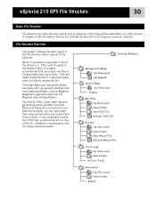
...Detail Maps Up One Level Empty My POIs Up One Level New Folder New POI File Default POI File Routes Up One Level New Folder New Route File Default Route File Track Logs Up One Level New Folder Active Track Geocaches Up One Level New Folder Empty It is based on a GPS receiver... any other filing system used before on the file system that you upload a detailed map from mapping software, such as Magellan MapSend or geocache files from the Magellan Geocaching software. eXplorist 210 GPS File Structure 30 Basic File Structure The eXplorist has a file structure system that is internal to the...
...Detail Maps Up One Level Empty My POIs Up One Level New Folder New POI File Default POI File Routes Up One Level New Folder New Route File Default Route File Track Logs Up One Level New Folder Active Track Geocaches Up One Level New Folder Empty It is based on a GPS receiver... any other filing system used before on the file system that you upload a detailed map from mapping software, such as Magellan MapSend or geocache files from the Magellan Geocaching software. eXplorist 210 GPS File Structure 30 Basic File Structure The eXplorist has a file structure system that is internal to the...

Manual - English
Page 35
...Creating a new Track Log File: Use the Arrow joystick to be returned to the last viewed Map screen. • Creating new Folders: You can now browse through the file structure to find... of the things you have selected the desired location, highlight Save in here and press ENTER. eXplorist 210 GPS File Structure 32 Using the Filing System with Track Logs • Track logs are saved differently ... that there is correct, highlight OK and press ENTER. Use the Arrow joystick to save a POI, details about creating new folders, new files, etc. If you want you want to highlight Save and press ...
...Creating a new Track Log File: Use the Arrow joystick to be returned to the last viewed Map screen. • Creating new Folders: You can now browse through the file structure to find... of the things you have selected the desired location, highlight Save in here and press ENTER. eXplorist 210 GPS File Structure 32 Using the Filing System with Track Logs • Track logs are saved differently ... that there is correct, highlight OK and press ENTER. Use the Arrow joystick to save a POI, details about creating new folders, new files, etc. If you want you want to highlight Save and press ...
Manual - English
Page 36
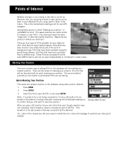
...Saving these places is included as part of POIs available for your eXplorist 210: POIs that you position" or just MARK for any GPS navigator. Quick Marking Your Position This saves your present position in ...back to them in and press ENTER. Points of Interest 33 Whether driving in a car, hiking on the trail or out for an afternoon sail, you are going to want to save... have heard the term "waypoints" to save places you've been in your eXplorist so you are accessed from a detailed map. This elevation is being computed, a warning will be used independently or combined to...
...Saving these places is included as part of POIs available for your eXplorist 210: POIs that you position" or just MARK for any GPS navigator. Quick Marking Your Position This saves your present position in ...back to them in and press ENTER. Points of Interest 33 Whether driving in a car, hiking on the trail or out for an afternoon sail, you are going to want to save... have heard the term "waypoints" to save places you've been in your eXplorist so you are accessed from a detailed map. This elevation is being computed, a warning will be used independently or combined to...

Manual - English
Page 40
..., nearest or alphabetical. 1. From here you can be found later in alphabetical order. • Searching for a POI that have been preloaded into the eXplorist, nearest to your position or in alphabetical order. • Ability to edit POI's you have saved. • Ability to delete POI's you have ...saved as well as a user-entered POI. • While viewing the list of POI's, the bearing and distance from the menu. Detailed information on the map the POI you have highlighted by Nearest. Once the database has been accessed and the POI selected you want a list of Interest. 3....
..., nearest or alphabetical. 1. From here you can be found later in alphabetical order. • Searching for a POI that have been preloaded into the eXplorist, nearest to your position or in alphabetical order. • Ability to edit POI's you have saved. • Ability to delete POI's you have ...saved as well as a user-entered POI. • While viewing the list of POI's, the bearing and distance from the menu. Detailed information on the map the POI you have highlighted by Nearest. Once the database has been accessed and the POI selected you want a list of Interest. 3....

Manual - English
Page 41
... nearest to searching for . (Five characters is very similar to searching for .) 10. Use the Arrow joystick in . 1. Press ENTER. 9. Detailed information on these functions can copy or view on the list to the POI you can be found later in a left /right motion to select... to highlight the POI desired. Use the Arrow joystick to highlight OK. 11. Use the Arrow joystick and the ENTER button to highlight Background Map. 5. Use the Arrow joystick in this manual. Press ENTER. 12. Press ENTER. 4. Use the Arrow joystick to highlight the category, (Cities...
... nearest to searching for . (Five characters is very similar to searching for .) 10. Use the Arrow joystick in . 1. Press ENTER. 9. Detailed information on these functions can copy or view on the list to the POI you can be found later in a left /right motion to select... to highlight the POI desired. Use the Arrow joystick to highlight OK. 11. Use the Arrow joystick and the ENTER button to highlight Background Map. 5. Use the Arrow joystick in this manual. Press ENTER. 12. Press ENTER. 4. Use the Arrow joystick to highlight the category, (Cities...

Manual - English
Page 45
... ENTER. 10. Press ENTER. 12. Press ESC to return to the detail screen of POI's found in locating the POI. 1. Use the Arrow joystick up/down to highlight View. 11. Points of Interest 42 Viewing a Preloaded POI on the Map Screen POI's that pressing the NAV button will be shown. 13. Press... POI database, you in step 8. Press ENTER. 4. Use the Arrow joystick left/right to continue. 8. Use the Arrow joystick to change the scale of the map displayed and if your position icon is within range, it will be viewed. 9. In step 13 if you are finished with the POI's in the...
... ENTER. 10. Press ENTER. 12. Press ESC to return to the detail screen of POI's found in locating the POI. 1. Use the Arrow joystick up/down to highlight View. 11. Points of Interest 42 Viewing a Preloaded POI on the Map Screen POI's that pressing the NAV button will be shown. 13. Press... POI database, you in step 8. Press ENTER. 4. Use the Arrow joystick left/right to continue. 8. Use the Arrow joystick to change the scale of the map displayed and if your position icon is within range, it will be viewed. 9. In step 13 if you are finished with the POI's in the...
Manual - English
Page 48
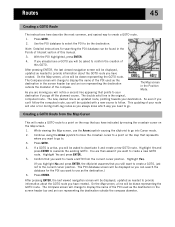
...Detailed instructions for the POI you go into Cursor mode. 2. destination if you want to use the Arrow joystick causing the eXplorist to go off the planned course. Creating a GOTO Route from the Map Cursor This will create a GOTO route to a point on the map that represents where you want to a point on the Map...of this manual. 3. Press GOTO. 4. Press ENTER. If you already have a GOTO you have created. While viewing the Map screen, use as the destination in the screen header bar and an icon representing the destination outside the compass diameter. Confirm ...
...Detailed instructions for the POI you go into Cursor mode. 2. destination if you want to use the Arrow joystick causing the eXplorist to go off the planned course. Creating a GOTO Route from the Map Cursor This will create a GOTO route to a point on the map that represents where you want to a point on the Map...of this manual. 3. Press GOTO. 4. Press ENTER. If you already have a GOTO you have created. While viewing the Map screen, use as the destination in the screen header bar and an icon representing the destination outside the compass diameter. Confirm ...
Manual - English
Page 64
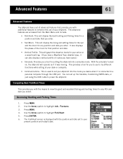
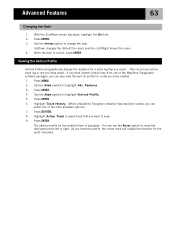
... display a vertical profile of routes you have a MapSend Topo detailed map, it is connected to a personal computer through the USB port. Computing Best Fish/Hunt Times This provides you with the position and date set to your eXplorist into a simulate mode. The Fish/Hunt screen is displayed with... or just using the USB cable to highlight Adv. Press MENU. 2. Features. 3. Press ENTER. 6. Advanced Features 61 Advanced Features The eXplorist has a set of advanced features that provides you with additional features to enhance the use to try different functions while sitting at your desk ...
... display a vertical profile of routes you have a MapSend Topo detailed map, it is connected to a personal computer through the USB port. Computing Best Fish/Hunt Times This provides you with the position and date set to your eXplorist into a simulate mode. The Fish/Hunt screen is displayed with... or just using the USB cable to highlight Adv. Press MENU. 2. Features. 3. Press ENTER. 6. Advanced Features 61 Advanced Features The eXplorist has a set of advanced features that provides you with additional features to enhance the use to try different functions while sitting at your desk ...
Manual - English
Page 66
... ENTER. 6. As you select. Press MENU. 2. Press ENTER. This can be your active track log or one you have loaded a detail map from one of the MapSend Topographic software packages, you can also view the vertical profile for a track log that you have saved. You can... select one of the other available options.) 7. Highlight Track History. (When a MapSend Topograhic detailed map has been loaded, you have created. 1. Use the Arrow joystick to move the profile, the center mark will graphically display the elevation for ...
... ENTER. 6. As you select. Press MENU. 2. Press ENTER. This can be your active track log or one you have loaded a detail map from one of the MapSend Topographic software packages, you can also view the vertical profile for a track log that you have saved. You can... select one of the other available options.) 7. Highlight Track History. (When a MapSend Topograhic detailed map has been loaded, you have created. 1. Use the Arrow joystick to move the profile, the center mark will graphically display the elevation for ...
Manual - English
Page 75
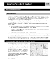
...-click inside the region. Using the eXplorist with MapSend 72 Using the eXplorist with MapSend What is the Magellan line of detailed digital maps for Magellan hand-held GPS receivers. MapSend maps will be uploaded and saved as one of the detailed maps available for your MapSend product for a...maps for driving, topographic maps for hiking, camping, and hunting, and fresh/salt water maps for using the Windows® operating system. • MapSend maps typically cover large areas, allowing the user to 'cut' smaller regions to details on -line www.magellangps.com under Products > Maps...
...-click inside the region. Using the eXplorist with MapSend 72 Using the eXplorist with MapSend What is the Magellan line of detailed digital maps for Magellan hand-held GPS receivers. MapSend maps will be uploaded and saved as one of the detailed maps available for your MapSend product for a...maps for driving, topographic maps for hiking, camping, and hunting, and fresh/salt water maps for using the Windows® operating system. • MapSend maps typically cover large areas, allowing the user to 'cut' smaller regions to details on -line www.magellangps.com under Products > Maps...
Manual - English
Page 77
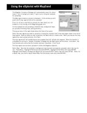
... that will be saved. Click Finish. Press Menu. Highlight Detail Maps or Background Maps field and press ENTER. Using the eXplorist with MapSend 74 The Magellan Conversion Manager will automatically search for detail maps (*.imi) or background maps (*.mgi) on the Magnifying glass icon. (In this window...for uploading. In this example we are uploading a detailed map, background maps are uploaded following these same guidelines.) The popup menu to either the Magellan eXplorist. The map regions will be uploaded. Click Next. The map region has now been uploaded to the right shows ...
... that will be saved. Click Finish. Press Menu. Highlight Detail Maps or Background Maps field and press ENTER. Using the eXplorist with MapSend 74 The Magellan Conversion Manager will automatically search for detail maps (*.imi) or background maps (*.mgi) on the Magnifying glass icon. (In this window...for uploading. In this example we are uploading a detailed map, background maps are uploaded following these same guidelines.) The popup menu to either the Magellan eXplorist. The map regions will be uploaded. Click Next. The map region has now been uploaded to the right shows ...

Manual - English
Page 83
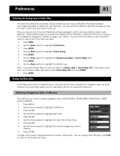
...you need to access POIs, routes, and other saved data, the eXplorist automatically goes to the default file for the particular piece of Preferences to change . 7. In Active Setup, you can also choose which background map or detailed map you are accessing. Use the Arrow joystick to use the Active Setup... portion of data you want to select Select File or (POI, Route, Detail Map, etc.) File Off. Background maps cannot be taken to change these defaults to more meet your data. If you selected Select File, using the Arrow joystick to...
...you need to access POIs, routes, and other saved data, the eXplorist automatically goes to the default file for the particular piece of Preferences to change . 7. In Active Setup, you can also choose which background map or detailed map you are accessing. Use the Arrow joystick to use the Active Setup... portion of data you want to select Select File or (POI, Route, Detail Map, etc.) File Off. Background maps cannot be taken to change these defaults to more meet your data. If you selected Select File, using the Arrow joystick to...
Manual - English
Page 84
... to select the detail map you have a detail map saved, select Detail Map Off and press ENTER. 9. Use the Arrow joystick to highlight the desired map. Press MENU. 2. Press ENTER. 4. Use the Arrow joystick to highlight Preferences. 3. Note: If you select Detail Map, you want to highlight the Background Maps or Detail Maps field. 7. Selecting Navigational Units of Measure The eXplorist can use...
... to select the detail map you have a detail map saved, select Detail Map Off and press ENTER. 9. Use the Arrow joystick to highlight the desired map. Press MENU. 2. Press ENTER. 4. Use the Arrow joystick to highlight Preferences. 3. Note: If you select Detail Map, you want to highlight the Background Maps or Detail Maps field. 7. Selecting Navigational Units of Measure The eXplorist can use...
User Manual
Page 3
... once to easily create and store lots of waypoints, routes, map regions, etc. • Some maps regions are available as needed. 1 Using MapSend What is the Magellan line of detailed digital maps for Magellan hand-held GPS receivers. The eXplorist can load them all at www.magellangps.com under Products/Maps and Software. • Most MapSend products are limited in...
... once to easily create and store lots of waypoints, routes, map regions, etc. • Some maps regions are available as needed. 1 Using MapSend What is the Magellan line of detailed digital maps for Magellan hand-held GPS receivers. The eXplorist can load them all at www.magellangps.com under Products/Maps and Software. • Most MapSend products are limited in...
User Manual
Page 7
... maps in a subdirectory, or another map you decided to view highly detailed mapping information, you locate your eXplorist. To activate a detail map, push the Menu button on the eXplorist, then select Preferences on your map file. You can be able to different maps, either stored internally or on SD cards. Summary Following these instructions you are ready to use your Magellan eXplorist...
... maps in a subdirectory, or another map you decided to view highly detailed mapping information, you locate your eXplorist. To activate a detail map, push the Menu button on the eXplorist, then select Preferences on your map file. You can be able to different maps, either stored internally or on SD cards. Summary Following these instructions you are ready to use your Magellan eXplorist...


