
Manual - English
Page 9
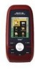
... still, even without a GPS fix, and no matter how you hold the receiver. (GPS receivers without an electronic compass require that can be installed in Europe may have local area base maps preloaded. The Magellan Triton was designed for the Magellan Triton 300, loaded onto the internal memory. SD-card expansion - (Triton 400 & 500 only) Use an optional SD memory card to add detailed...
... still, even without a GPS fix, and no matter how you hold the receiver. (GPS receivers without an electronic compass require that can be installed in Europe may have local area base maps preloaded. The Magellan Triton was designed for the Magellan Triton 300, loaded onto the internal memory. SD-card expansion - (Triton 400 & 500 only) Use an optional SD memory card to add detailed...
Manual - English
Page 10
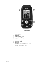
A B C E F G D I H Magellan Triton A Backlight Button B Power Button C Zoom - (Zoom out) Button D Zoom + (Zoom in) Button E ENTER Button / Cursor Control F PAGE / GO TO Button G Esc (Escape) Button H Menu Button I SD Card Slot (under protective rubber cover) [Magellan Triton 400 & 500 only] Overview 2
A B C E F G D I H Magellan Triton A Backlight Button B Power Button C Zoom - (Zoom out) Button D Zoom + (Zoom in) Button E ENTER Button / Cursor Control F PAGE / GO TO Button G Esc (Escape) Button H Menu Button I SD Card Slot (under protective rubber cover) [Magellan Triton 400 & 500 only] Overview 2

Manual - English
Page 11
...) diagonal, QVGA (240 x 320) resolution, LED backlit Internal memory or Secure Digital (SD) Card (optional accessory) Built-in base map of the continental United States and Canada. (In Europe...access keys 14° to 140°F (-10° to 60°C) PERFORMANCE Receiver Acquisition Time Update Rate Accuracy Languages Coordinate Systems SiRF Star III™ 20 channels, ...: 20 seconds, Cold: 60 seconds, Initial: 2 minutes Once per second 3 to 10 hours Overview 3 GPS only English, French, German, Dutch, Danish, Swedish, Spanish, Italian, Portuguese, Finnish, Norwegian Latitude/Longitude,...
...) diagonal, QVGA (240 x 320) resolution, LED backlit Internal memory or Secure Digital (SD) Card (optional accessory) Built-in base map of the continental United States and Canada. (In Europe...access keys 14° to 140°F (-10° to 60°C) PERFORMANCE Receiver Acquisition Time Update Rate Accuracy Languages Coordinate Systems SiRF Star III™ 20 channels, ...: 20 seconds, Cold: 60 seconds, Initial: 2 minutes Once per second 3 to 10 hours Overview 3 GPS only English, French, German, Dutch, Danish, Swedish, Spanish, Italian, Portuguese, Finnish, Norwegian Latitude/Longitude,...

Manual - English
Page 14
...7. Menus Accessing the features of the internal base map or a destination waypoint found on an optional SD card (400 & 500) or into the Magellan Triton. Accessing the Main Menu 1. Check the Magellan website at www.magellangps.com for a known waypoint. Use the Waypoint option to create waypoints and ... saves battery life if you have created previously that has been saved to your present location, by selecting a point on updates to the Magellan Triton. Select Settings. 4. The Waypoint option provides a way to create a Go To route to a waypoint that you have saved previously. ...
...7. Menus Accessing the features of the internal base map or a destination waypoint found on an optional SD card (400 & 500) or into the Magellan Triton. Accessing the Main Menu 1. Check the Magellan website at www.magellangps.com for a known waypoint. Use the Waypoint option to create waypoints and ... saves battery life if you have created previously that has been saved to your present location, by selecting a point on updates to the Magellan Triton. Select Settings. 4. The Waypoint option provides a way to create a Go To route to a waypoint that you have saved previously. ...
Manual - English
Page 16
... select the detailed map you want to change what information is being displayed from the list shown and press ENTER. 6. The Triton will appear before the name of the map when it has been activated. 6. Customizing the Data Field for the Large Data,...4. Select View. 3. Highlight the detailed map from the Magellan Store and installed using the optional National Geographic software. Magellan Triton 300 installs the National Geographic maps into their internal memory, while Magellan Triton 400 and 500 stores the maps on an SD card. Select Maps. 4. Select OK. Use the cursor control ...
... select the detailed map you want to change what information is being displayed from the list shown and press ENTER. 6. The Triton will appear before the name of the map when it has been activated. 6. Customizing the Data Field for the Large Data,...4. Select View. 3. Highlight the detailed map from the Magellan Store and installed using the optional National Geographic software. Magellan Triton 300 installs the National Geographic maps into their internal memory, while Magellan Triton 400 and 500 stores the maps on an SD card. Select Maps. 4. Select OK. Use the cursor control ...
Manual - English
Page 40
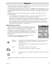
... the SD card and not in creating a route. Waypoint Information Media Used to navigating and creating routes. Waypoints Waypoints are the key to enter or modify data for the waypoint. User-created waypoints are used for the waypoint. The Magellan Triton has ...three different classifications for each waypoint. This screen provides a way to the Triton memory. The Magellan Triton automatically assigns a name for the waypoint using the convention of three...
... the SD card and not in creating a route. Waypoint Information Media Used to navigating and creating routes. Waypoints Waypoints are the key to enter or modify data for the waypoint. User-created waypoints are used for the waypoint. The Magellan Triton has ...three different classifications for each waypoint. This screen provides a way to the Triton memory. The Magellan Triton automatically assigns a name for the waypoint using the convention of three...

Manual - English
Page 50
...can be found on the internet. Geocache information includes Difficulty (1 through 5 with 5 being the most difficult), Terrain (1 though 5 with GPS users. Select Go To. Premium members of the person who hid the cache (Hider). 6. If you are marking a new cache location ... 3. They post these geocache waypoints into the Magellan Triton. Press the PAGE / GO TO button to the VantagePoint software and uploading it into your Magellan Triton either by creating a geocache waypoint or by saving the geocache file from the SD card installed in finding the cache. Press PAGE /...
...can be found on the internet. Geocache information includes Difficulty (1 through 5 with 5 being the most difficult), Terrain (1 though 5 with GPS users. Select Go To. Premium members of the person who hid the cache (Hider). 6. If you are marking a new cache location ... 3. They post these geocache waypoints into the Magellan Triton. Press the PAGE / GO TO button to the VantagePoint software and uploading it into your Magellan Triton either by creating a geocache waypoint or by saving the geocache file from the SD card installed in finding the cache. Press PAGE /...
Manual - English
Page 65
... List and Grid View to change how the images are images available on the right side of the media options you need install an optional SD card in full screen. Media Before using any of the Magellan Triton. Press + ZOOM to display the image in the...
... List and Grid View to change how the images are images available on the right side of the media options you need install an optional SD card in full screen. Media Before using any of the Magellan Triton. Press + ZOOM to display the image in the...


