
Triton User Manual Addendum - English, French, Spanish
Page 1
...Grid. (Advanced Users) You can set a user grid as the Coordinate System for the perimeter and area. Area Calculation. The Triton receiver can calculate the perimeter and area of the space defined by pressing the MENU button. When you want to begin recording your track...applies to Triton GPS receivers that have a software version that you can now access the Main Menu on any navigational screen press ENTER. The most noticeable change in the software is that is displayed with options to it's current location, point B. Triton 300 Triton 400 Triton 500 Triton 1500 Triton 2000 01...
...Grid. (Advanced Users) You can set a user grid as the Coordinate System for the perimeter and area. Area Calculation. The Triton receiver can calculate the perimeter and area of the space defined by pressing the MENU button. When you want to begin recording your track...applies to Triton GPS receivers that have a software version that you can now access the Main Menu on any navigational screen press ENTER. The most noticeable change in the software is that is displayed with options to it's current location, point B. Triton 300 Triton 400 Triton 500 Triton 1500 Triton 2000 01...
Manual - English
Page 7
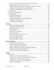
... 38 Setting Volume and Brightness 38 View Memory Usage 38 Clearing Memory 39 Restoring Factory Settings 39 Setting Connectivity 39 Getting Software Version Information 40 Viewing Copyright Information 40 Personalizing Magellan Triton 40 Performing Diagnostic Checks 40 Geocache Waypoints ...42 Creating a Geocache Waypoint 42 Editing a Saved Geocache Waypoint 42 Deleting a Saved Geocache Waypoint... Waypoint 45 Creating a Go To Route to a Place Waypoint 46 Creating a Go To Route to a Geocache Waypoint 46 Creating a Multileg Route 46 Table of Contents Magellan Triton 3
... 38 Setting Volume and Brightness 38 View Memory Usage 38 Clearing Memory 39 Restoring Factory Settings 39 Setting Connectivity 39 Getting Software Version Information 40 Viewing Copyright Information 40 Personalizing Magellan Triton 40 Performing Diagnostic Checks 40 Geocache Waypoints ...42 Creating a Geocache Waypoint 42 Editing a Saved Geocache Waypoint 42 Deleting a Saved Geocache Waypoint... Waypoint 45 Creating a Go To Route to a Place Waypoint 46 Creating a Go To Route to a Geocache Waypoint 46 Creating a Multileg Route 46 Table of Contents Magellan Triton 3

Manual - English
Page 9
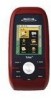
.... Features of the Magellan Triton Ease-of-use the backtrack function to follow your point of origin. 3-meter accuracy - Get accurate compass readings while standing still, even without a GPS fix, and no matter how you hold the receiver. (GPS receivers without an electronic compass require that can be kept informed of possible software updates and new features...
.... Features of the Magellan Triton Ease-of-use the backtrack function to follow your point of origin. 3-meter accuracy - Get accurate compass readings while standing still, even without a GPS fix, and no matter how you hold the receiver. (GPS receivers without an electronic compass require that can be kept informed of possible software updates and new features...
Manual - English
Page 16
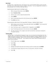
... screen, and the Satellite Status screen have data fields that can be purchased and downloaded from the Magellan Store and installed using the optional National Geographic software. Customizing the Data Field for the Large Data, Compass or Satellite Status Screen 1. Press ESC when... first data field will need to select the detailed map you want to select the desired field. 4. Magellan Triton 300 installs the National Geographic maps into their internal memory, while Magellan Triton 400 and 500 stores the maps on an SD card. Fundamentals 8 Select Maps. 4. Select View. ...
... screen, and the Satellite Status screen have data fields that can be purchased and downloaded from the Magellan Store and installed using the optional National Geographic software. Customizing the Data Field for the Large Data, Compass or Satellite Status Screen 1. Press ESC when... first data field will need to select the detailed map you want to select the desired field. 4. Magellan Triton 300 installs the National Geographic maps into their internal memory, while Magellan Triton 400 and 500 stores the maps on an SD card. Fundamentals 8 Select Maps. 4. Select View. ...
Manual - English
Page 48
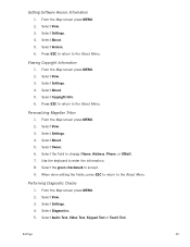
... to return to change (Name, Address, Phone, or EMail). 7. Select the field to the About Menu. Select the green checkmark to the About Menu. Getting Software Version Information 1. Personalizing Magellan Triton 1. Select About. 5. When done editing the fields, press ESC to return to accept. 9. Performing Diagnostic Checks 1. Select Copyright Info. 6. Settings 40
... to return to change (Name, Address, Phone, or EMail). 7. Select the field to the About Menu. Select the green checkmark to the About Menu. Getting Software Version Information 1. Personalizing Magellan Triton 1. Select About. 5. When done editing the fields, press ESC to return to accept. 9. Performing Diagnostic Checks 1. Select Copyright Info. 6. Settings 40

Manual - English
Page 50
...Difficulty (1 through 5 with 5 being the most difficult), and the name of Geocaching.com can use the keyboard to the VantagePoint software and uploading it into their Magellan Triton. Press PAGE / GO TO to find . 1. Editing a Saved Geocache Waypoint 1. You then enter these locations on Map or ... the most difficult), Terrain (1 though 5 with GPS users. People will have hints and descriptions included to access the Options page where you can be found on or off. 9. They post these geocache waypoints into your Magellan Triton either by creating a geocache waypoint or by saving...
...Difficulty (1 through 5 with 5 being the most difficult), and the name of Geocaching.com can use the keyboard to the VantagePoint software and uploading it into their Magellan Triton. Press PAGE / GO TO to find . 1. Editing a Saved Geocache Waypoint 1. You then enter these locations on Map or ... the most difficult), Terrain (1 though 5 with GPS users. People will have hints and descriptions included to access the Options page where you can be found on or off. 9. They post these geocache waypoints into your Magellan Triton either by creating a geocache waypoint or by saving...
Manual - English
Page 62
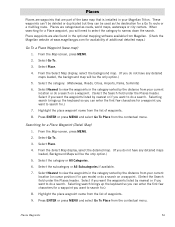
Places Places are waypoints that is installed in your Magellan Triton. Place waypoints are categorized as the destination for .) 7. Select Place. 4. From the Map screen, press MENU. 2. Select the category or All Categories. 6. Select the subcategory ..., select the background map. (If you want the waypoints listed by the distance from your current location (or cursor position if in the optional mapping software available from the list of waypoints. 8. Searching for a waypoint you do a search. Select Place. 4. Select Go To. 3. Press ENTER or press MENU and select Go...
Places Places are waypoints that is installed in your Magellan Triton. Place waypoints are categorized as the destination for .) 7. Select Place. 4. From the Map screen, press MENU. 2. Select the category or All Categories. 6. Select the subcategory ..., select the background map. (If you want the waypoints listed by the distance from your current location (or cursor position if in the optional mapping software available from the list of waypoints. 8. Searching for a waypoint you do a search. Select Place. 4. Select Go To. 3. Press ENTER or press MENU and select Go...
